Report on Semeru (Indonesia) — July 2022

Bulletin of the Global Volcanism Network, vol. 47, no. 7 (July 2022)
Managing Editor: Benjamin Andrews.
Edited by Kadie L. Bennis.
Semeru (Indonesia) Pyroclastic flows, gas-and-ash emissions, and crater incandescence during January-June 2022
Please cite this report as:
Global Volcanism Program, 2022. Report on Semeru (Indonesia) (Bennis, K.L., and Andrews, B., eds.). Bulletin of the Global Volcanism Network, 47:7. Smithsonian Institution. https://doi.org/10.5479/si.GVP.BGVN202207-263300
Semeru
Indonesia
8.108°S, 112.922°E; summit elev. 3657 m
All times are local (unless otherwise noted)
Semeru, located in East Java, Indonesia, contains the active Jonggring-Seloko vent at the Mahameru summit. Hundreds of eruptive events occurred during the 19th and 20th centuries, including nearly continuous activity since 1967. Eruptions have been characterized by Vulcanian and Strombolian explosions, lava flows, pyroclastic flows, lava domes, and lahars. The current eruption has been ongoing since April 2014 and has more recently consisted of explosions, ash plumes, lava flows, pyroclastic flows, lahars, and dome collapse. An eruption and dome collapse occurred near the summit on 4 December 2021, which produced a notable ash plume and pyroclastic flows, the latter of which generated major lahars (BGVN 47:01). As a result, several communities were partially buried, causing fatalities and significant damage. This report covers intermittent pyroclastic flows, incandescent avalanches, and ash eruptions during January through June 2022 using daily and VONA reports from the Pusat Vulkanologi dan Mitigasi Bencana Geologi (PVMBG, also known as Indonesian Center for Volcanology and Geological Hazard Mitigation, CVGHM), the Darwin Volcanic Ash Advisory Centre (VAAC), and various satellite data.
Activity during January 2022 consisted of continuous nighttime crater incandescence, gray-white ash emissions, and occasional pyroclastic flows and avalanches. Gray-white ash emissions were reported rising 50-1,000 m above the summit and drifted in different directions. Near daily white gas-and-steam emissions rose as high as 1 km above the summit crater. Pyroclastic flows occurred on 1, 5, 6, 7, 8, 9, and 17 January and primarily descended the Kobokan (SE) and Lengkong drainages, traveling 700-5,000 m. Incandescent avalanches traveled 700 m and 500 m down the Kobokan drainage during 6-7 and 11-12 January, respectively. A collapse from the end of the active lava flow in the Kobokan drainage generated a pyroclastic flow and an ash plume that rose 1.5 km high and drifted N at 1020 on 16 January.
During February, activity was relatively low and consisted of gray-white ash emissions rising 50-700 m above the summit and drifting in multiple directions, and occasional nighttime crater incandescence. White gas-and-steam emissions rose as high as 1.2 km above the crater rim. The active lava flow on the SE flank measured 3.5 km long. According to PVMBG, pyroclastic flows were reported on 2 February. Avalanches were detected during 7-8 February and descended 100-200 m toward the Kobokan drainage. A series of eruptions were detected at 0554 and 0709 on 17 February, 0558 on 18 February, 0551 on 19 February, and 0701 on 20 February that generated ash plumes 500-700 m high and drifted N, W, and SW. Eruptions were also recorded at 0605 on 24 February, 0538, 0557, and 0755 on 25 February, 0535 on 27 February, and 0555 on 29 February that produced ash plumes 700 m high.
During March, gray-white ash emissions rose 200-1,800 m above the summit and drifted mainly N, W, and SW. On 2 March two incandescent lava avalanches were reported moving 200-300 m down the Kobokan drainage, accompanied by white-gray emissions that rose 500 m high and drifted SW. On 3 March an ash plume was detected rising 4.2 km above the summit, based on ground observers, and later that day, at 2004, a pyroclastic flow originated from the end of a lava flow and descended as far as 4.5 km down the Kobokan drainage on the SE flank. Intermittent ash plumes continued to be reported in VONA notices, rising 400-1,000 m high and drifting in various directions. Pyroclastic flows were detected on 1, 4, and 13 March, though weather often obscured the travel distance and direction. Nighttime crater incandescence was visible on 5 March. Avalanches were reported during 12-13 and 22 March, though they were not visually confirmed. On 22 March a pyroclastic flow originated from the end of a lava flow and descended the Kobokan drainage, producing an ash plume that rose 1.5 km above the summit and drifted SE.
Eruptive events during April consisted of near daily ash plumes that rose 200-1,000 m above the summit and drifted in different directions; white gas-and-steam emissions rose 200-300 m high. Cloudy weather sometimes prevented visual observations of the activity. On 1 April avalanches were reported. A strong thermal anomaly was detected in infrared satellite imagery on 3 April, according to a Darwin VAAC notice. Ash plumes during May rose 200-700 m high and drifting mainly N, S, and SW and white gas-and-steam emissions rose 100-700 m above the summit. On 1 May at 0630 a pyroclastic flow that originated from the end of the lava flow on the SE flank was detected, producing ash plumes that rose as high as 500 m above the summit (figure 73). Similar activity continued to be recorded during June; ash plumes rose 200-700 m above the summit and drifted generally N, W, and SW. White gas-and-steam emissions rose 100-600 m high and drifted in different directions.
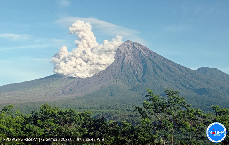 |
Figure 73. Webcam image of a pyroclastic flow descending the SE flank of Semeru at 0636 on 1 May 2022. The accompanying ash plume rose 500 m high. Courtesy of MAGMA Indonesia. |
MIROVA (Middle InfraRed Observation of Volcanic Activity) analysis of MODIS satellite data showed intermittent thermal anomalies of varying power during January through June (figure 74). Beginning in May, the frequency of these anomalies increased. Based on data from the MODVOLC thermal algorithm, a total of 56 thermal hotspots were detected: five in January, five in February, three in March, two in April, 29 in May, and 12 in June. Thermal anomalies were visible on clear weather days in the summit crater, occasionally extending toward the SE flank; on 25 April two thermal anomalies were visible: one in the summit crater and the second farther down the SE flank (figure 73). The increase in thermal activity was a result of a persistent lava flow that descended the SE flank during mid-May through June, based on infrared satellite images from Sentinel-2 (figure 74). By 19 June the flow no longer seemed to advance.
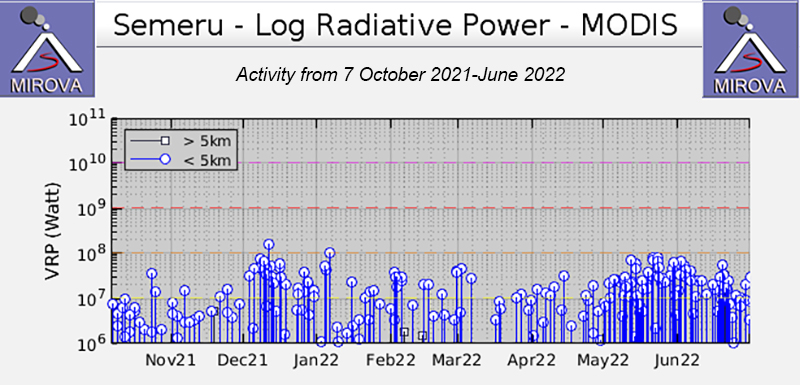 |
Figure 74. Intermittent thermal activity was recorded in the MIROVA graph (Log Radiative Power) during January through June 2022, with gradual power fluctuations. Beginning in May, the frequency and power of the anomalies gradually increased. This increased frequency could be due to more than one anomaly occurring at the summit crater, as well as on the nearby flanks. Courtesy of MIROVA. |
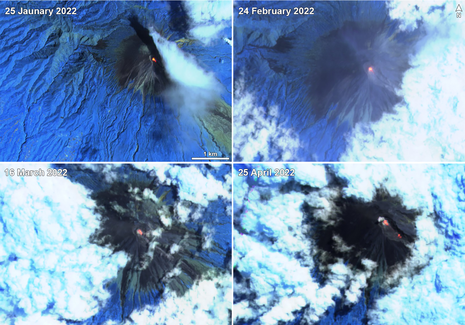 |
Figure 75. A continuous bright thermal anomaly (bright yellow-orange) was visible on clear weather days at the summit crater of Semeru on 25 January 2022 (top left), 24 February 2022 (top right), 16 March 2022 (bottom left), and 25 April 2022 (bottom right). Each of these anomalies also appeared to extend toward the SE flank from the summit crater. On 25 April two anomalies were detected: one in the summit crater and the second father down the SE flank. Images use “Atmospheric penetration” rendering (bands 12, 11, 8a). Courtesy of Sentinel Hub Playground. |
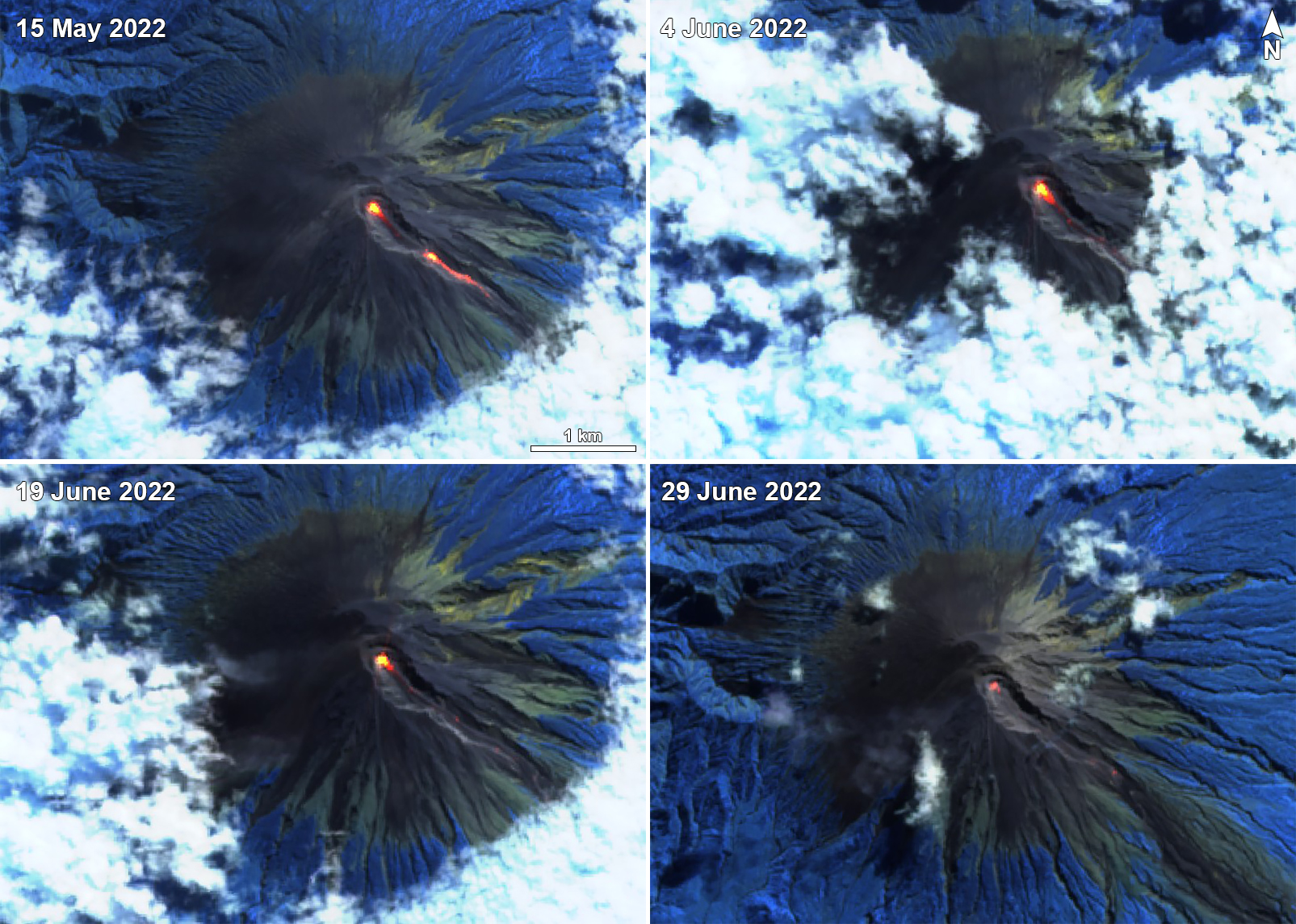 |
Figure 76. Sentinel-2 infrared satellite imagery showing a strong lava flow originating from the summit crater of Semeru and descending the SE flank on 15 May 2022 (top left), 4 June 2022 (top right), 19 June 2022 (bottom left), and 29 June 2022 (bottom right). By 19 June the flow no longer seemed to advance down the SE flank, and by 29 June the anomaly in the summit crater visible decreased in size compared to the previous days. Images use “Atmospheric penetration” rendering (bands 12, 11, 8a). Courtesy of Sentinel Hub Playground. |
Geological Summary. Semeru, the highest volcano on Java, and one of its most active, lies at the southern end of a volcanic massif extending north to the Tengger caldera. The steep-sided volcano, also referred to as Mahameru (Great Mountain), rises above coastal plains to the south. Gunung Semeru was constructed south of the overlapping Ajek-ajek and Jambangan calderas. A line of lake-filled maars was constructed along a N-S trend cutting through the summit, and cinder cones and lava domes occupy the eastern and NE flanks. Summit topography is complicated by the shifting of craters from NW to SE. Frequent 19th and 20th century eruptions were dominated by small-to-moderate explosions from the summit crater, with occasional lava flows and larger explosive eruptions accompanied by pyroclastic flows that have reached the lower flanks of the volcano.
Information Contacts: Pusat Vulkanologi dan Mitigasi Bencana Geologi (PVMBG, also known as Indonesian Center for Volcanology and Geological Hazard Mitigation, CVGHM), Jalan Diponegoro 57, Bandung 40122, Indonesia (URL: http://www.vsi.esdm.go.id/); Darwin Volcanic Ash Advisory Centre (VAAC), Bureau of Meteorology, Northern Territory Regional Office, PO Box 40050, Casuarina, NT 0811, Australia (URL: http://www.bom.gov.au/info/vaac/); MAGMA Indonesia, Kementerian Energi dan Sumber Daya Mineral (URL: https://magma.esdm.go.id/v1); MIROVA (Middle InfraRed Observation of Volcanic Activity), a collaborative project between the Universities of Turin and Florence (Italy) supported by the Centre for Volcanic Risk of the Italian Civil Protection Department (URL: http://www.mirovaweb.it/); Hawai'i Institute of Geophysics and Planetology (HIGP) - MODVOLC Thermal Alerts System, School of Ocean and Earth Science and Technology (SOEST), Univ. of Hawai'i, 2525 Correa Road, Honolulu, HI 96822, USA (URL: http://modis.higp.hawaii.edu/); Sentinel Hub Playground (URL: https://www.sentinel-hub.com/explore/sentinel-playground); National Public Radio (NPR) (URL: https://www.npr.org/2021/12/05/1061611299/indonesia-volcano-eruption-java-mount-semeru).