Report on Semeru (Indonesia) — July 2023

Bulletin of the Global Volcanism Network, vol. 48, no. 7 (July 2023)
Managing Editor: Benjamin Andrews.
Edited by Kadie L. Bennis.
Semeru (Indonesia) Ash plumes, incandescent avalanches, and pyroclastic flows during January-June 2023
Please cite this report as:
Global Volcanism Program, 2023. Report on Semeru (Indonesia) (Bennis, K.L., and Andrews, B., eds.). Bulletin of the Global Volcanism Network, 48:7. Smithsonian Institution.
Semeru
Indonesia
8.108°S, 112.922°E; summit elev. 3657 m
All times are local (unless otherwise noted)
Semeru contains the active Jonggring-Seloko vent at the Mahameru summit and is located in East Java, Indonesia. Frequent 19th and 20th century eruptions were dominated by small-to-moderate explosions from the summit crater, with occasional lava flows and larger explosive eruptions accompanied by pyroclastic flows that have reached the lower flanks of the volcano. The current eruption began in June 2017 and more recently has been characterized by intermittent gas-and-ash plumes and incandescent avalanches (BGVN 48:01). This report updates activity such as ash plumes, incandescent avalanches, and pyroclastic flows from January through June 2023, based on information from daily, VONA, and special reports from the Pusat Vulkanologi dan Mitigasi Bencana Geologi (PVMBG, also known as Indonesian Center for Volcanology and Geological Hazard Mitigation, CVGHM), MAGMA Indonesia, and various satellite data.
Activity during January and February mainly consisted of frequent ash plumes and white-and-gray emissions. The ash plumes during January rose 200-1,000 m above the crater and drifted in different directions. The white-and-gray emissions rose 200-1,000 m above the crater. A photo was posted on social media that showed an incandescent lava flow extending 500 m from the summit crater on the SE flank at 0027 on 8 January (figure 83). Video posted to social media on 5 February showed a pyroclastic flow descending the SE flank and ash plumes rising along the path and drifting N. Ash plumes rose 1 km above the crater at 0802 on 13 January, at 0536 on 17 January, at 0628 on 19 January and drifted SW, W, and SE, respectively. White, gray, and brown emissions were reported on 15 and 17 January that rose 300-1,000 m above the crater. During February, ash plumes rose 200-1,500 m above the crater and drifted mainly N and NE. White-and-gray emissions rose 100-1,000 m above the crater.
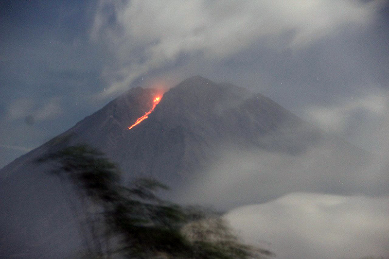 |
Figure 83. Photo showing an incandescent lava flow descending 500 m on the SE flank of Semeru at 0027 on 8 January 2023. Photo has been color corrected. Courtesy of Info Semeru. |
Similar activity consisting of frequent ash plumes and gas-and-steam emissions continued through March and April. During March, ash plumes rose 300-1,200 m above the crater and drifted in multiple directions. On 25 March at 0738 an ash plume rose 1.2 km above the crater and drifted SE. Occasional white-and-gray emissions rose 50-1,000 m above the crater. Ash plumes in April rose 400-1,200 m above the crater and drifted in different directions. An ash plume on 3 April rose 1.2 km above the crater and drifted SE and S at 0538. On 8 April a photo and videos were posted on social media showing a pyroclastic flow moving 1.5 km down the SE flank, accompanied by an ash plume (figure 84). New material was deposited along the crater, according to a local news source. Another pyroclastic flow occurred at 0710 on 18 April that descended up to 2 km from the crater to the SE (figure 85). White-and-gray emissions rose 100-800 m above the crater during April.
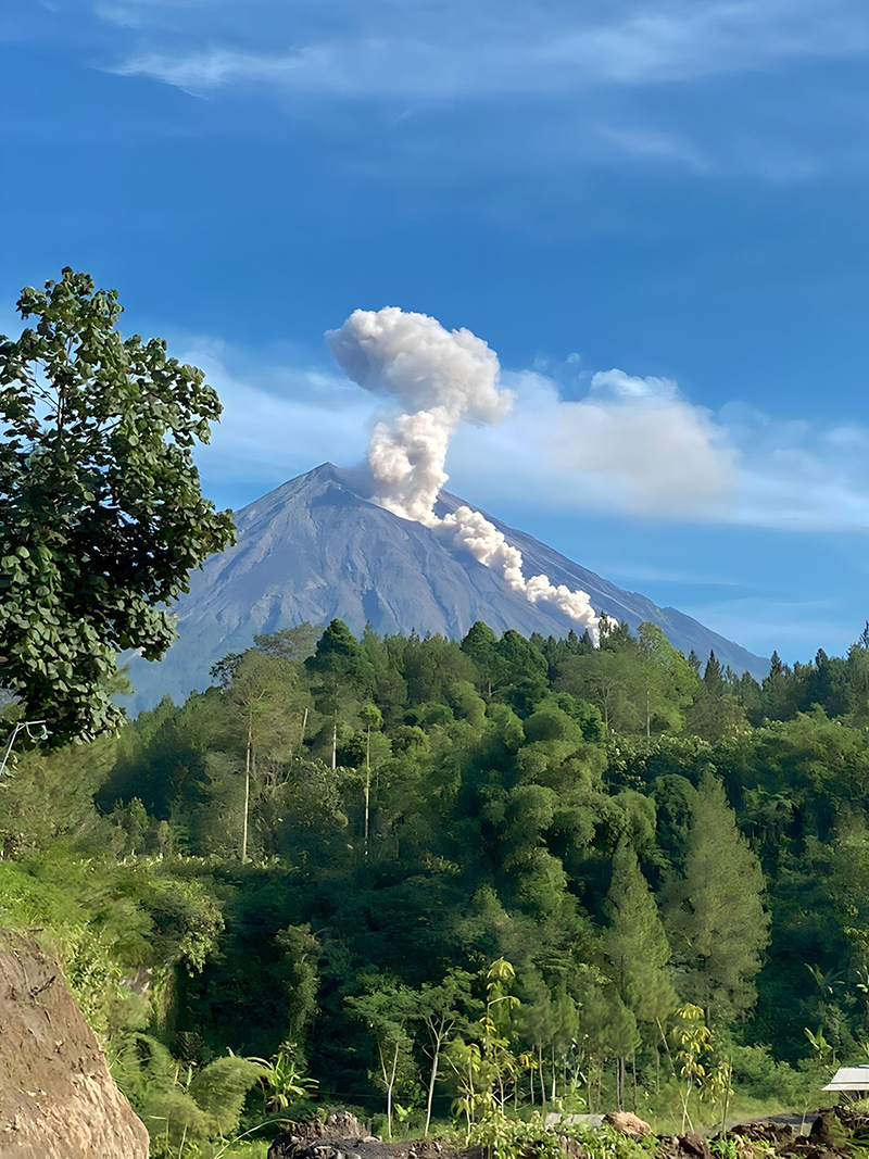 |
Figure 84. Photo showing a pyroclastic flow descending the SE flank of Semeru on 8 April 2023. Courtesy of Info Semeru. |
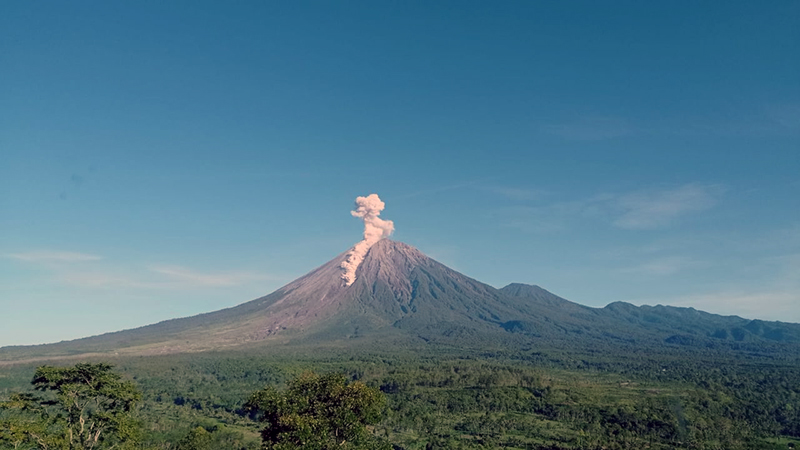 |
Figure 85. Photo showing a pyroclastic flow descending 2 km on the SE flank of Semeru on 18 April 2023. Photo has been color corrected. Courtesy of Info Semeru. |
Ash plumes and white-and-gray emissions persisted during May and June. During May, ash plumes rose 300-1,200 m above the crater and drifted generally N and S. On 13 May around 1012 a pyroclastic flow was observed moving 1.5 km down the SE flank, accompanied by an ash plume (figure 86). On 27 May an ash plume rose 1.2 km above the crater and drifted S and SW at 0819. White-and-gray emissions rose 100-800 m above the crater. Ash plumes during June rose 200-1,500 m above the crater and generally drifted N and SW. A webcam image showed incandescent material at the summit and on the flanks at 0143 on 23 June that traveled 3.5 km. According to a local news source, a pyroclastic flow traveled 5 km down the SE flank at 1910 on 26 June; the accompanying an ash plume rose as high as 1.5 km above the crater and drifted NE and E. Dominantly white gas-and-steam emissions rose 50-300 m above the crater.
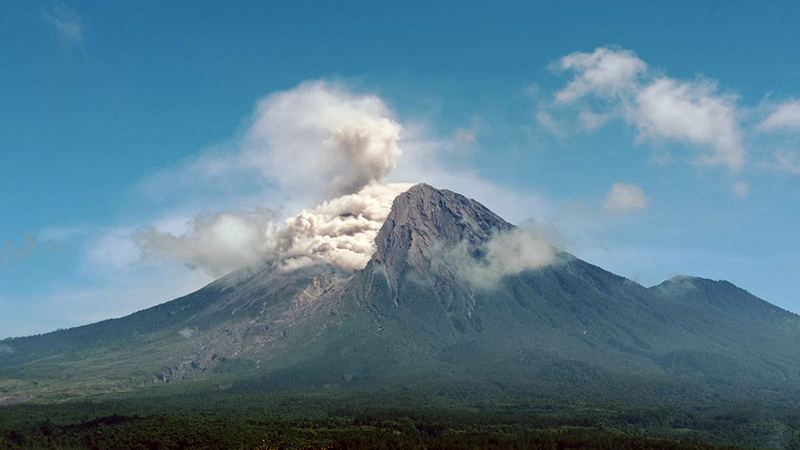 |
Figure 86. Photo of a pyroclastic flow descending the SE flank of Semeru as far as 1.5 km at 1012 on 13 May 2023. Photo has been color corrected. Courtesy of Info Semeru. |
MIROVA (Middle InfraRed Observation of Volcanic Activity) analysis of MODIS satellite data showed frequent and moderate-power thermal anomalies during January through June 2023 (figure 87). There was a short gap in activity during late January through late February, followed by low-power and less frequent anomalies through April. During mid-May, there was an increase in both power and frequency of the anomalies. A total of 73 thermal hotspots were detected, based on data from the MODVOLC thermal algorithm. There were 10 detected in January, four in March, two in April, 17 in May, and 40 in June. Infrared satellite images showed persistent thermal activity at the summit crater during the reporting period; strong incandescent avalanches of material were occasionally captured in these images and affected the SE flank (figure 88).
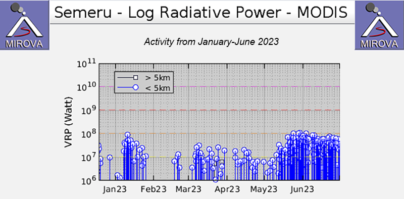 |
Figure 87. Frequent, moderate-power thermal anomalies were detected at Semeru during January through June 2023, according to this MIROVA graph (Log Radiative Power). There was a short gap in activity during late January through late February, and lower-power anomalies were registered during late February through April; during mid-May there was an increase in both power and frequency of the anomalies. Courtesy of MIROVA. |
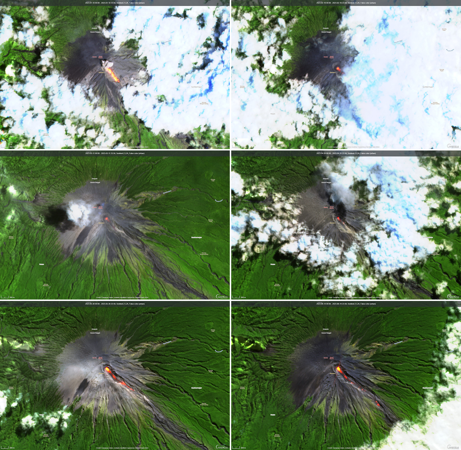 |
Figure 88. Infrared (bands B12, B11, B4) satellite images showed strong thermal activity at Semeru on 10 January 2023 (top left), 19 February 2023 (top right), 11 March 2023 (middle left), 20 April 2023 (middle right), 30 May 2023 (bottom left), and 14 June 2023 (bottom right). Incandescent material mainly affected the SE flank from the summit crater, as shown in each of these images. Courtesy of Copernicus Browser. |
Geological Summary. Semeru, the highest volcano on Java, and one of its most active, lies at the southern end of a volcanic massif extending north to the Tengger caldera. The steep-sided volcano, also referred to as Mahameru (Great Mountain), rises above coastal plains to the south. Gunung Semeru was constructed south of the overlapping Ajek-ajek and Jambangan calderas. A line of lake-filled maars was constructed along a N-S trend cutting through the summit, and cinder cones and lava domes occupy the eastern and NE flanks. Summit topography is complicated by the shifting of craters from NW to SE. Frequent 19th and 20th century eruptions were dominated by small-to-moderate explosions from the summit crater, with occasional lava flows and larger explosive eruptions accompanied by pyroclastic flows that have reached the lower flanks of the volcano.
Information Contacts: Pusat Vulkanologi dan Mitigasi Bencana Geologi (PVMBG, also known as Indonesian Center for Volcanology and Geological Hazard Mitigation, CVGHM), Jalan Diponegoro 57, Bandung 40122, Indonesia (URL: http://www.vsi.esdm.go.id/); MAGMA Indonesia, Kementerian Energi dan Sumber Daya Mineral (URL: https://magma.esdm.go.id/v1); Badan Nasional Penanggulangan Bencana (BNPB), National Disaster Management Agency, Graha BNPB - Jl. Scout Kav.38, East Jakarta 13120, Indonesia (URL: http://www.bnpb.go.id/); MIROVA (Middle InfraRed Observation of Volcanic Activity), a collaborative project between the Universities of Turin and Florence (Italy) supported by the Centre for Volcanic Risk of the Italian Civil Protection Department (URL: http://www.mirovaweb.it/); Hawai'i Institute of Geophysics and Planetology (HIGP) - MODVOLC Thermal Alerts System, School of Ocean and Earth Science and Technology (SOEST), Univ. of Hawai'i, 2525 Correa Road, Honolulu, HI 96822, USA (URL: http://modis.higp.hawaii.edu/); Copernicus Browser, Copernicus Data Space Ecosystem, European Space Agency (URL: https://dataspace.copernicus.eu/browser/); Info Semeru (Twitter: @info_semeru, https://twitter.com/info_semeru).