Report on Santa Maria (Guatemala) — February 1988

Scientific Event Alert Network Bulletin, vol. 13, no. 2 (February 1988)
Managing Editor: Lindsay McClelland.
Santa Maria (Guatemala) Lava descends S flank valley; lahars fill channels
Please cite this report as:
Global Volcanism Program, 1988. Report on Santa Maria (Guatemala) (McClelland, L., ed.). Scientific Event Alert Network Bulletin, 13:2. Smithsonian Institution. https://doi.org/10.5479/si.GVP.SEAN198802-342030
Santa Maria
Guatemala
14.757°N, 91.552°W; summit elev. 3745 m
All times are local (unless otherwise noted)
The quoted material is a report from William Rose.
"Santiaguito was observed by scientists from INSIVUMEH, Michigan Tech and Arizona State Universities, and the Smithsonian Institution 10-16 February, the initial days of an intensive volcanic hazard study that will continue until April.
"Caliente vent was the focus of activity, as it has been for every observation since 1977. A dacite lava flow 3.5 km long was being extruded and was advancing SSW, filling the steep valley of a tributary of the Río Nimá II (figure 4). The flow is the result of continuous extrusion from Caliente vent since 1975. During the first 9 years, the extrusion fed a lava flow that extended only a few hundreds of meters from the vent, where it oversteepened, generating incandescent avalanches and small block and ash flows (Rose, 1987). Lava began to descend the southern slopes of Caliente vent in June 1986, but the flow was much more extensive in May and June 1987. Its movement is now generating incandescent rockfalls and small block and ash flows. These affect the upper, steeper parts of the lava flow and an oversteepened mound downslope (over a constricted part of the former river drainage into which the flow is channeled). The present flow is the longest yet observed in Santiaguito's 66 years of continuous activity and represents an increase in the extrusion rate since 1985. This is the seventh period of rapid extrusion at Santiaguito. Previous episodes have recurred about every 10-12 years and lasted about 3-5 years.
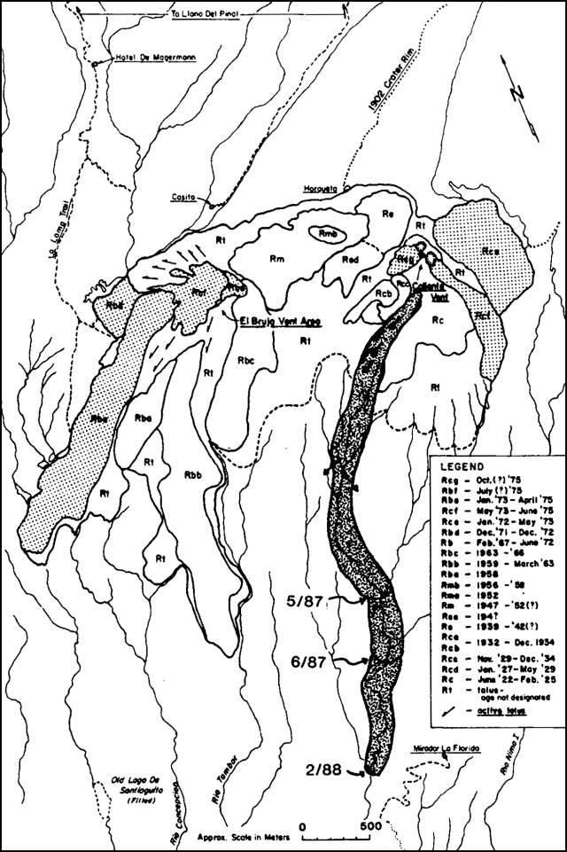 |
Figure 4. Map of Santiaguito Dome, showing the ages of its lobes. The 1986-88 flow is emphasized by a shaded pattern; other recent lobes are stippled. Successive positions of the 1986-88 flow front are dated. Courtesy of William Rose. |
"Caliente vent is also the source of vertical, possibly phreatomagmatic eruptions of fine-grained dacite ash, very similar to those described 1975-84. They occur as often as 1 or 2 times an hour and consist of very brief (1-2-minute) emissions, some of which reached altitudes of 4,000 m (about 1,500 m above the vent). Light ashfalls (<0.1 mm thick) affect areas as much as 6 km from Santiaguito." The geologists who visited Tacaná on 27-28 January also made observations from about 2 km W of Santiaguito on 30 January. Steam and ash were ejected at 0930 and 1000. A local observer, Alejandro Chávez, reported some roaring, whistling noises, and very minor seismicity.
"An important result of the current activity has been the accelerating sedimentary load (chiefly laharic) into river systems downslope (figure 5). Most now enters the Río Nimá II, which has aggraded by at least several tens of meters for its entire length. The formerly incised channels are now filled and in many places the riverbed is far above the elevation of former confluences with tributaries, resulting in their damming and redirection. The situation has caused increasingly difficult problems for residents of villages and plantations in the area. The most serious affect the town of El Palmar, which has been frequently flooded by the Río Nimá I.
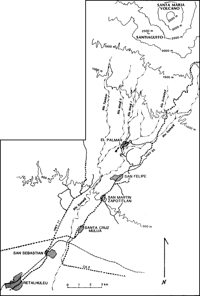 |
Figure 5. Sketch map of rivers and towns S of Santiaguito. Locations of drainages are approximate. The location of the former confluence of the Río Nima I with the Río Nima II near El Palmar is marked with an arrow. Courtesy of William Rose. |
"Blocked from its former confluence with the Río Nimá II by mudflow accumulations, it now flows through El Palmar into the Río Samalá (figure 5). At El Palmar, the Río Nimá II flows less than 100 m from the Río Nimá I, with no remaining topographic barriers other than mudflow levees. Erratic mudflow deposition in the coming rainy season could divert the entire Río Nimá II, including its mudflow load, via the Río Nimá I into the Río Samalá over a waterfall more than 100 m high, at a point 3 km N of the present confluence. Near San Felipe (14 km SSW of Santiaguito), the Río Nimá II aggraded by more than 20 m during the last rainy season (May-November 1987). Similar aggradations occurred as far south as San Sebastián (22 km SSW of Santiaguito) in the Río Samalá, which receives the Río Nimá II just W of San Felipe. Because of strongly parallel drainage systems, filling of the Río Nimá II and the Río Samalá must eventually result in overflow into nearby rivers, which are at significantly lower levels. The consequences of such stream diversions are complex and hard to rigorously forecast, but such problems occupy much of the current hazard study because the area S of El Palmar is densely populated."
Reference. Rose, W.I., 1987, Volcanic activity at Santiaguito Volcano, 1976-1984 in Fink, J., ed., The Emplacement of Silicic Domes and Lava Flows: GSA Special Paper 212, p. 17-27.
Geological Summary. Symmetrical, forest-covered Santa María volcano is part of a chain of large stratovolcanoes that rise above the Pacific coastal plain of Guatemala. The sharp-topped, conical profile is cut on the SW flank by a 1.5-km-wide crater. The oval-shaped crater extends from just below the summit to the lower flank, and was formed during a catastrophic eruption in 1902. The renowned Plinian eruption of 1902 that devastated much of SW Guatemala followed a long repose period after construction of the large basaltic-andesite stratovolcano. The massive dacitic Santiaguito lava-dome complex has been growing at the base of the 1902 crater since 1922. Compound dome growth at Santiaguito has occurred episodically from four vents, with activity progressing E towards the most recent, Caliente. Dome growth has been accompanied by almost continuous minor explosions, with periodic lava extrusion, larger explosions, pyroclastic flows, and lahars.
Information Contacts: W.I. Rose, Reinaldo Mercado, and James Vallance, Michigan Tech UniversityOtoniel Matías, Jorge Girón, and Francisco Alvarez, INSIVUMEH; J. Fink and Steve Anderson, Arizona State University; Lee Siebert, SI; Gerardo Sánchez Rubio, Estación Regional del Centro, Instituto de Geología, UNAM, Guanajuato, México.