Report on Apoyeque (Nicaragua) — April 1989
Scientific Event Alert Network Bulletin, vol. 14, no. 4 (April 1989)
Managing Editor: Lindsay McClelland.
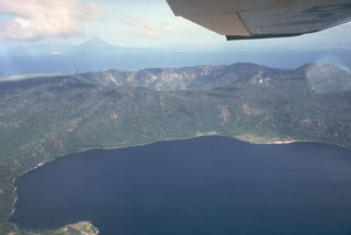
Apoyeque (Nicaragua) Lake temperature measured
Please cite this report as:
Global Volcanism Program, 1989. Report on Apoyeque (Nicaragua) (McClelland, L., ed.). Scientific Event Alert Network Bulletin, 14:4. Smithsonian Institution. https://doi.org/10.5479/si.GVP.SEAN198904-344091
Apoyeque
Nicaragua
12.242°N, 86.342°W; summit elev. 518 m
All times are local (unless otherwise noted)
Surface temperature of the lake (measured with an 8-14 micrometer bandpass radiometer) varied between 28 and 30°C during fieldwork 8 April. A water temperature measured near the N shore was 25.5°C.
Geological Summary. The Apoyeque volcanic complex occupies the broad Chiltepe Peninsula, which extends into south-central Lake Managua. The peninsula is part of the Chiltepe pyroclastic shield volcano, one of three large ignimbrite shields on the Nicaraguan volcanic front. A 2.8-km wide, 400-m-deep, lake-filled caldera whose floor lies near sea level truncates the low Apoyeque edifice, which rises only about 500 m above the lake shore. The caldera was the source of a thick deposit of dacitic pumice that covers the surrounding area. The 2.5 x 3 km lake-filled Xiloá (Jiloá) maar is located immediately SE of Apoyeque. The Talpetatl lava dome was constructed between Laguna Xiloá and Lake Managua. Pumiceous pyroclastic flows from Laguna Xiloá were erupted about 6,100 years ago and overlie deposits of comparable age from the Masaya Plinian eruption.
Information Contacts: C. Oppenheimer, Open Univ.