Report on Momotombo (Nicaragua) — 2 December-8 December 2015
Smithsonian Institution / US Geological Survey
Weekly Volcanic Activity Report, 2 December-8 December 2015
Managing Editor: Sally Sennert.
Please cite this report as:
Global Volcanism Program, 2015. Report on Momotombo (Nicaragua) (Sennert, S, ed.). Weekly Volcanic Activity Report, 2 December-8 December 2015. Smithsonian Institution and US Geological Survey.
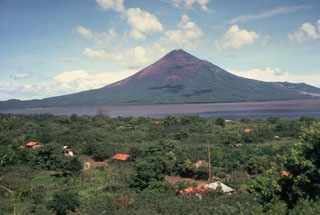
Momotombo
Nicaragua
12.423°N, 86.539°W; summit elev. 1270 m
All times are local (unless otherwise noted)
Based on satellite and webcam observations, and seismic data, the Washington VAAC reported that during 2-3 December ash plumes from Momotombo rose to an altitude of 2.4 km (8,000 ft) a.s.l. and drifted 90-225 km NW and WNW.
Geological Summary. Momotombo is a young stratovolcano that rises prominently above the NW shore of Lake Managua, forming one of Nicaragua's most familiar landmarks. Momotombo began growing about 4500 years ago at the SE end of the Marrabios Range and consists of a somma from an older edifice that is surmounted by a symmetrical younger cone with a 150 x 250 m wide summit crater. Young lava flows extend down the NW flank into the 4-km-wide Monte Galán caldera. The youthful cone of Momotombito forms an island offshore in Lake Managua. Momotombo has a long record of Strombolian eruptions, punctuated by occasional stronger explosive activity. The latest eruption, in 1905, produced a lava flow that traveled from the summit to the lower NE base. A small black plume was seen above the crater after a 10 April 1996 earthquake, but later observations noted no significant changes in the crater. A major geothermal field is located on the south flank.