Report on Ugashik-Peulik (United States) — 12 May-18 May 2021
Smithsonian Institution / US Geological Survey
Weekly Volcanic Activity Report, 12 May-18 May 2021
Managing Editor: Sally Sennert.
Please cite this report as:
Global Volcanism Program, 2021. Report on Ugashik-Peulik (United States) (Sennert, S, ed.). Weekly Volcanic Activity Report, 12 May-18 May 2021. Smithsonian Institution and US Geological Survey.
Ugashik-Peulik
United States
57.751°N, 156.368°W; summit elev. 1474 m
All times are local (unless otherwise noted)
On 12 May AVO changed the Aviation Color Code and Volcano Alert Level for Ugashik-Peulik to Green and Normal, respectively, reflecting that communication with seismic stations had been re-established, allowing for the location of earthquakes and detection of unrest.
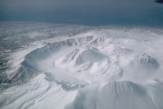
Geological Summary. The Ugashik-Peulik volcanic complex lies south of Becharof Lake and east of Upper Ugashik Lake. Late-Pleistocene caldera formation was followed by the emplacement of at least five Holocene lava domes within the 4.5-km-wide caldera. Most of the caldera walls consist of basement sandstones of Jurassic age. Following caldera formation the small, 3 km3 Peulik stratovolcano grew 2.5 km to the N. Lava flows from Peulik cover the caldera rim to the south and extend to Becharof Lake, 6 km N. A small lava dome on the E flank of Peulik was the source of a small block-and-ash flow. The summit of Peulik contains a 1.5-km-wide crater breached to the west that is partially filled by a lava dome. Debris-avalanche deposits cover a 75 km2 area to the NW. A single documented historical eruption took place from Peulik in 1814.
Source: US Geological Survey Alaska Volcano Observatory (AVO)