Report on Cotopaxi (Ecuador) — 19 October-25 October 2022
Smithsonian Institution / US Geological Survey
Weekly Volcanic Activity Report, 19 October-25 October 2022
Managing Editor: Sally Sennert.
Please cite this report as:
Global Volcanism Program, 2022. Report on Cotopaxi (Ecuador) (Sennert, S, ed.). Weekly Volcanic Activity Report, 19 October-25 October 2022. Smithsonian Institution and US Geological Survey.
Cotopaxi
Ecuador
0.677°S, 78.436°W; summit elev. 5911 m
All times are local (unless otherwise noted)
IG reported minor eruptive activity at Cotopaxi. A low-amplitude tremor signal recorded by the seismic network from 1950 on 21 October to 0040 on 22 October was associated with gas-and-ash emissions. The emissions were not visible due to darkness and weather conditions, but minor ashfall and a sulfur odor was reported by mountaineers in the Refugio José Rivas, 2 km N of the summit crater; the mountaineers evacuated. The Washington VAAC reported that during 2150-2200 on 21 October ash plumes rose to 7.6-8.5 (25,000-28,000 ft) a.s.l. and drifted NE based on information from IG and the Guayaquil MWO, satellite images, and webcam views. The ash had dissipated by 0410 on 22 October. A second ash plume was identified in webcam and satellite images rising to 7 km (23,000 ft) a.s.l. and drifting W at 0700 on 22 October. Ash was no longer visible by 1250. IG noted that following the end of the tremor signal seismicity declined and plumes of gas-and-steam rose as high as 1 km above the summit and drifted W. Based on the reports from IG the Servicio Nacional de Gestión de Riesgos y Emergencias (SNGRE) raised the Alert Level to Yellow (the second lowest level on a four-color scale) on 22 October.
Weather conditions at the volcano improved on 23 October and a layer of dark gray ash on the volcano, deposited the previous two days, became visible. Based on seismic data and media reports, small secondary lahars generated from the melted glacier beneath the ash deposit, were recorded during 1115-1300 and traveled short distances down the flanks. Weather clouds frequently prevented views of the volcano during 24-25 October, though steam emissions rising 200 m above the summit and drifting W were visible during a break in the cloud cover the morning of 25 October.
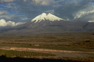
Geological Summary. The symmetrical, glacier-covered, Cotopaxi stratovolcano is Ecuador's most well-known volcano and one of its most active. The steep-sided cone is capped by nested summit craters, the largest of which is about 550 x 800 m in diameter. Deep valleys scoured by lahars radiate from the summit of the andesitic volcano, and large andesitic lava flows extend to its base. The modern edifice has been constructed since a major collapse sometime prior to about 5,000 years ago. Pyroclastic flows (often confused in historical accounts with lava flows) have accompanied many explosive eruptions, and lahars have frequently devastated adjacent valleys. Strong eruptions took place in 1744, 1768, and 1877. Pyroclastic flows descended all sides of the volcano in 1877, and lahars traveled more than 100 km into the Pacific Ocean and western Amazon basin. Smaller eruptions have been frequent since that time.
Sources: Instituto Geofísico-Escuela Politécnica Nacional (IG-EPN), Servicio Nacional de Gestión de Riesgos y Emergencias (SNGRE)

