Report on Machin (Colombia) — 30 November-6 December 2022
Smithsonian Institution / US Geological Survey
Weekly Volcanic Activity Report, 30 November-6 December 2022
Managing Editor: Sally Sennert.
Please cite this report as:
Global Volcanism Program, 2022. Report on Machin (Colombia) (Sennert, S, ed.). Weekly Volcanic Activity Report, 30 November-6 December 2022. Smithsonian Institution and US Geological Survey.
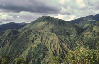
Machin
Colombia
4.487°N, 75.389°W; summit elev. 2749 m
All times are local (unless otherwise noted)
On 2 December SGC reported that an increase in seismicity was detected at Cerro Machín beginning at 1123 on 2 December, with signals indicating rock fracturing. By 1320 a total of 393 signal were counted. The largest event, a M 4.5 recorded at 1236, was located 900 m SSW of the main dome at a depth of 3 km and was felt in Cajamarca (14 km WSW), Ibagué (17 km ESE), and in other municipalities of Tolima. The Alert Level remained at 3 (Yellow; the second lowest level on a four-color scale).
Geological Summary. The small Cerro Machín stratovolcano lies at the southern end of the Ruiz-Tolima massif about 20 km WNW of the city of Ibagué. A 3-km-wide caldera is breached to the south and contains three forested dacitic lava domes. Voluminous pyroclastic flows traveled up to 40 km away during eruptions in the mid-to-late Holocene, perhaps associated with formation of the caldera. Late-Holocene eruptions produced dacitic block-and-ash flows that traveled through the breach in the caldera rim to the west and south. The latest known eruption of took place about 800 years ago.