Report on East Epi (Vanuatu) — 1 February-7 February 2023
Smithsonian Institution / US Geological Survey
Weekly Volcanic Activity Report, 1 February-7 February 2023
Managing Editor: Sally Sennert.
Please cite this report as:
Global Volcanism Program, 2023. Report on East Epi (Vanuatu) (Sennert, S, ed.). Weekly Volcanic Activity Report, 1 February-7 February 2023. Smithsonian Institution and US Geological Survey.
East Epi
Vanuatu
16.6797°S, 168.3893°E; summit elev. 833 m
All times are local (unless otherwise noted)
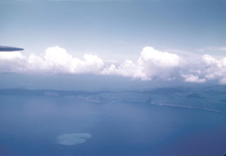
According to the Vanuatu Meteorology and Geo-Hazards Department (VMGD) an overflight of Epi was conducted during the afternoon of 31 January. Steam was observed rising from the ocean’s surface above Epi B, water around the eruption site was discolored, and rafts of pumice were floating on the surface following the currents. Several strands of pumice rafts to the SW, NW, and N of Epi B were visible in 2 February Sentinel B satellite images. During 0700-1030 on 7 February residents observed minor, low-level steaming above Epi B. The intensity of steam emissions varied, increasing and decreasing as new lava was erupted from Epi B. Steaming was again reported by residents starting around 0600 on 8 February. The seismic network recorded elevated seismicity during the previous few days.
Geological Summary. The submarine East Epi group of basaltic and dacitic cones are located within a possible 10-km-diameter caldera off the NE coast of southern Epi Island in Vanuatu. Three cones (1-1.5 basal diameter), known as Epi A, Epi B (or Cioan), and Epi C, are located along the northern rim of the inferred caldera, though Beier et al. (2018) suggest an alternate to the post-caldera formation model. A few smaller cones are south of Epi B. Ephemeral islands were formed during eruptions at Epi B in 1920 and 1953. Explosive activity was reported in 1958 and 1960, discolored water was often seen during 1971-1974 and 1988, a new vent was detected in 1979, and explosive activity occurred in 1999, 2002, 2004, and 2023. The summit was at 34 m below sea level at the time of a 2001 survey, and a research cruise in 2013 (R/V Sonne SO-229; Haase et al, 2013) sampled six cones, including "very fresh pumice and lava bombs" from Epi B and "relatively old-looking" material from the others. The SO-229 cruise also recovered rhyodacitic pumice with mafic streaks, similar to that sampled by previous cruises, and described Epi B as "covered by massive blocks of pumice."
Sources: Vanuatu Meteorology and Geohazards Department (VMGD), Sentinel Hub