Report on Shishaldin (United States) — 12 July-18 July 2023
Smithsonian Institution / US Geological Survey
Weekly Volcanic Activity Report, 12 July-18 July 2023
Managing Editor: Sally Sennert.
Please cite this report as:
Global Volcanism Program, 2023. Report on Shishaldin (United States) (Sennert, S, ed.). Weekly Volcanic Activity Report, 12 July-18 July 2023. Smithsonian Institution and US Geological Survey.
Shishaldin
United States
54.756°N, 163.97°W; summit elev. 2857 m
All times are local (unless otherwise noted)
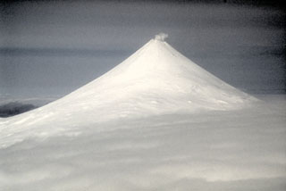
AVO reported that a new eruption at Shishaldin began after increasing activity. Intermittent tremor and low-frequency earthquakes had gradually become more regular and consistent during 10-11 July, and strongly elevated surface temperatures at the summit were identified in satellite images those same days. The Volcano Alert Level was raised to Advisory (the second level on a four-level scale) and the Aviation Color Code was raised to Yellow (the second color on a four-color scale). Late on 11 July incandescence at the summit was observed in web camera images. Strongly elevated surface temperatures continued to be observed in satellite data and seismic tremor amplitudes increased during 11-12 July; sulfur dioxide emissions were also detected. The observations suggested that lava was likely present at the summit crater, so AVO raised the Volcano Alert Level to Watch and the Aviation Color Code to Orange. The US Coast Guard conducted an overflight on 12 July and confirmed that lava was erupting at the summit.
A significant explosion at 0109 on 14 July produced an ash plume that rose 9-12 km (30,000-40,000 ft) a.s.l. and drifted S. Webcam images and photos taken at around 0700 from a ship SW of Unimak Island showed small lahar deposits (from the interaction of hot pyroclastic material and snow and ice) on the flanks as well as ashfall on the SW and N flanks. A smaller explosion at 0710 generated an ash plume that rose 4.5 km (14,800 ft) a.s.l. Low-level ash emissions continued during the morning based on webcam images and pilot reports.
Seismic tremor amplitude began increasing at around 1700 and remained elevated. An ash plume at an altitude of 4.6 km (15,000 ft) a.s.l. and drifting SSE was visible in a satellite image at 2100. AVO stated that activity had intensified. At 2357 AVO raised the Aviation Color Code to Red and noted that seismicity had remained elevated for over six hours and explosion signals were frequently detected by regional infrasound (pressure sensor) networks. A continuous ash plume extended more than 125 km SSE at an altitude of 4.9 km (16,100 ft) a.s.l., though some of the explosions sent ash plumes as high as 6 km (19,700 ft) a.s.l. Strongly elevated surface temperatures were observed in satellite data during 15-16 July. By 0734 on 16 July explosive activity had declined and seismicity had significantly declined. The Aviation Color Code was lowered to Orange. A remnant ash cloud drifted about 500 km SE before dissipating. Lava continued to erupt at the summit during 16-17 July and produced strongly elevated surface temperatures visible in satellite images. Lava effusion increased at 0100 on 18 July, shown by elevated surface temperatures identified satellite data, increasing seismic tremor, and activity detected on regional infrasound arrays. Activity again intensified and at 0700 a rapidly expanding ash cloud was visible drifting SSE, eventually reaching 9.1 km (30,000 ft) a.s.l. The Aviation Color Code was raised to Red and the Volcano Alert Level was raised to Warning. A Volcano Observatory Notice to Aviation (VONA) issued at 0837 noted that the plume was rising to 7.3 km (24,000 ft) a.s.l. based on recent pilot observations. By 0930 the main ash plume had detached. The eruption gradually declined, so at 1208 the Volcano Alert Level was lowered to Watch and the Aviation Color Code was lowered to Orange. Continuing ash emissions generated plumes that drifted S at altitudes below 3 km (10,000 ft) a.s.l.
Geological Summary. The symmetrical glacier-covered Shishaldin in the Aleutian Islands is the westernmost of three large stratovolcanoes in the eastern half of Unimak Island. The Aleuts named the volcano Sisquk, meaning "mountain which points the way when I am lost." Constructed atop an older glacially dissected edifice, it is largely basaltic in composition. Remnants of an older edifice are exposed on the W and NE sides at 1,500-1,800 m elevation. There are over two dozen pyroclastic cones on its NW flank, which is covered by massive aa lava flows. Frequent explosive activity, primarily consisting of Strombolian ash eruptions from the small summit crater, but sometimes producing lava flows, has been recorded since the 18th century. A steam plume often rises from the summit crater.
Source: US Geological Survey Alaska Volcano Observatory (AVO)