Report on Ruang (Indonesia) — 17 April-23 April 2024
Smithsonian Institution / US Geological Survey
Weekly Volcanic Activity Report, 17 April-23 April 2024
Managing Editor: Sally Sennert.
Please cite this report as:
Global Volcanism Program, 2024. Report on Ruang (Indonesia) (Sennert, S, ed.). Weekly Volcanic Activity Report, 17 April-23 April 2024. Smithsonian Institution and US Geological Survey.
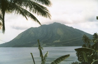
Ruang
Indonesia
2.3058°N, 125.3671°E; summit elev. 703 m
All times are local (unless otherwise noted)
PVMBG raised the Alert Level for Ruang to 2 (on a scale of 1-4) at 1300 on 16 April due to intensifying seismicity. A minor eruption began at around 1337 on 16 April and produced dense white emissions; at 1600 the Alert Level was raised to 3 (on a scale of 1-4). Explosive activity began at 2145 and ash plumes rose 2 km above the summit. Activity continued to escalate. An explosive pulse was recorded at 0108 on 17 April. According to the Darwin VAAC ash plumes had risen to 9.1 km (30,000 ft) a.s.l. and drifted W by 0230, and at 0300 they reached 12.2 km (40,000 ft) a.s.l. and detached from the summit. Ash plumes at a lower altitude of 4.6 km (15,000 ft) a.s.l. drifted WSW. BNPB reported that 828 people from Pumpente and Laingpatehi villages evacuated to neighboring Tagulandang Island to the NE and the communication network in Laingpatehi village was non-operational. Photos showed incandescent material being ejected above the summit, incandescent material on the flanks, pyroclastic density currents descending the flanks, and dense ash plumes with lightning rising into dark, nighttime skies. Another explosive pulse was recorded at 0505 according to PVMBG, and the VAAC noted that by 0600 ash plumes had risen to 13.7 km (45,000 ft) a.s.l. and drifted W and NW. The plume was detached from the summit by 0713. Additional smaller eruptive events produced ash plumes that rose to 1.5 km (5,000 ft) a.s.l. and drifted E.
PVMBG recorded bigger eruptive pulses at 1800 and 2015 on 17 April. Roaring and booming noises were sometimes heard, with gray-to-black ash plumes at 2015 and a felt earthquake. According to the VAAC ash plumes rose to 15.2 km (50,000 ft) a.s.l. by 2000 and at least to 19.2 km (63,000 ft) a.s.l. by 2020; the plumes drifted NW. PVMBG raised the Alert Level to 4, the highest level, at 2100 on 17 April noting that seismicity continued to increase, ash plumes were getting taller, and incandescent rocks were ejected as far as 5 km with some reaching Tagulandang Island. The public was warned to stay 6 km away from Ruang’s main crater. Several residents in Tagulandang were hit with tephra and some received medical treatment according to BNPB. Ashfall was recorded in as many as 10 villages in two sub-districts on Tagulandang and in several sub-districts of North Minahasa Regency (75 km SSW) including West Likupang, Wori, East Likupang, and South Likupang. Communication networks in Lumbo Village on Tagulandang were not properly functioning. An estimated 6,045 people living in the W part Tagulandang evacuated. According to a news article, there was damage to more than 3,000 homes, two churches, and an elementary school.
Multiple ash layers were identified in a satellite image 2310 on 17 April according to the VAAC; ash at 16.8 km (55,000 ft) a.s.l. drifted NW and E and ash at 14.3 km (47,000 ft) a.s.l. drifted WSW. At 0310 on 18 April ash plumes rose to 12.2 km and drifted WNW and W and detached from the volcano by 0600; earlier high-level plumes continued to expand as they drifted NW. According to a news report the Sam Ratulangi International Airport, 98 km SW in Manado, North Sulawesi, closed on 18 April due to the presence of ash.
The VAAC continued to track the plumes; lower-altitude plumes at 7.6 km (25,000 ft) a.s.l. drifted SE. The higher plumes, between 10.7-15.2 km (35,000-50,000 ft) a.s.l., continued to drift NW and WNW and had dissipated by 1710 on 19 April, though sulfur dioxide continued to be tracked W. Weather clouds began to obscure the plumes. On 19 April PVMBG reported that ash plumes rose 400-750 m above the summit and drifted S. During 20-21 April the VAAC issued notifications of ash plumes rising 1.5-2.1 km (5,000-7,000 ft) a.s.l. and drifting S and SW based on satellite images and information from PVMBG. The closure of the Sam Ratulangi International Airport affected 150 flights and about 19,085 passengers as of 20 April based on a news report; the airport resumed operations at noon on 22 April. PVMBG reported that during 21-23 April dense white steam-and-gas plumes rose as high as 200 m and drifted SW, W, and NW. The Alert Level was lowered to 3 at 0900 on 22 April because activity had decreased. Residents were warned to stay 4 km away from the crater.
Geological Summary. Ruang volcano is the southernmost volcano in the Sangihe Island arc, north of Sulawesi Island; it is not the better known Raung volcano on Java. The 4 x 5 km island volcano is across a narrow strait SW of the larger Tagulandang Island. The summit contains a crater partially filled by a lava dome initially emplaced in 1904. Explosive eruptions recorded since 1808 have often been accompanied by lava dome formation and pyroclastic flows that have damaged inhabited areas.
Sources: Pusat Vulkanologi dan Mitigasi Bencana Geologi (PVMBG, also known as CVGHM), Badan Nacional Penanggulangan Bencana (BNPB), Darwin Volcanic Ash Advisory Centre (VAAC), Antara News, Antara News, Tempo, VOI