
| Country | United States |
| Volcanic Region | Samoan Hotspot Volcano Group |
| Landform | Volc Type | Shield | Shield |
| Last Known Eruption | 2003 CE |
| Coordinates | 14.215°S, 169.058°W |
| Elevation | -592 m (-1,942 ft) |
| Volcano Number | 244000 |
 Google Earth Placemark with Features Google Earth Placemark with Features
| |
 Cite Volcano Profile Cite Volcano Profile
| |
The Global Volcanism Program has no Weekly Volcanic Activity Reports available for Vailulu'u.
Cite this Report
ALIA cruise discloses new cone in the summit crater
According to Hubert Staudigel (Scripps Institution of Oceanography) and Stanley Hart (Woods Hole Oceanographic Institute), Vailuluʻu seamount, the most active Samoan submarine volcano, erupted between April 2001 and April 2005. It formed a 293-m-tall lava cone, which was named Nafanua after the Samoan Goddess of War. This new cone had been growing inside the 2-km-wide caldera of Vailuluʻu at a minimum rate of about 20 cm/day since April 2001. Nafanua was discovered during a 2005 diving expedition with the National Oceanic and Atmospheric Agency (NOAA) research submersible Pisces V, launched from the University of Hawaii research vessel Kaimikai O Kanaloa (KOK). It is located in the originally 1,000-m-deep W crater of Vailuluʻu (figures 5 to 8).
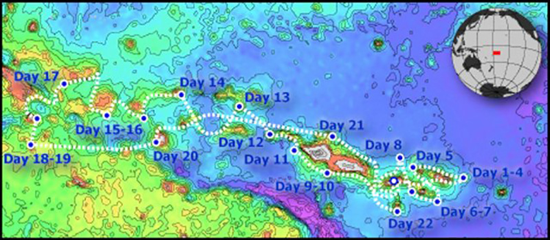 |
Figure 5. The route of the 2005 cruise of the research vessel Kilo Moana. Vailuluʻu, towards the E end of the Samoan hotspot trail was visited on cruise days 1-4, 4-8 April 2005. Courtesy of H. Staudigel and S. Hart. |
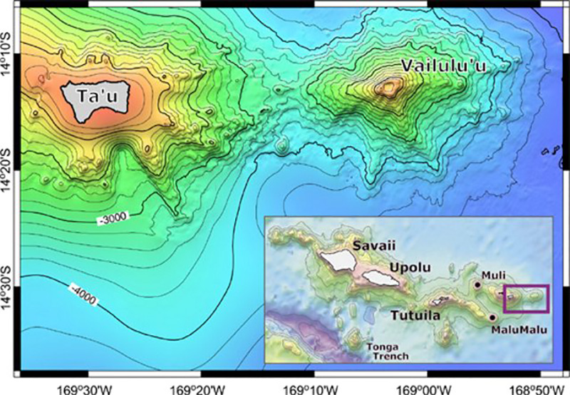 |
Figure 6. Bathymetry of Vailuluʻu and nearby Taʻu Island, based on a SeaBeam bathymetric survey performed during R/V Melville's AVON 2 and 3 cruises, augmented with satellite-derived bathymetry from Smith and Sandwell (1996). The inset shows the general location of Vailuluʻu with respect to the Samoan Archipelago; two other newly mapped and dredged seamounts (Malumalu and Muli, AVON 3 cruise) are shown as well. Scale: 10' = 18 km. From Hart and others (2000). |
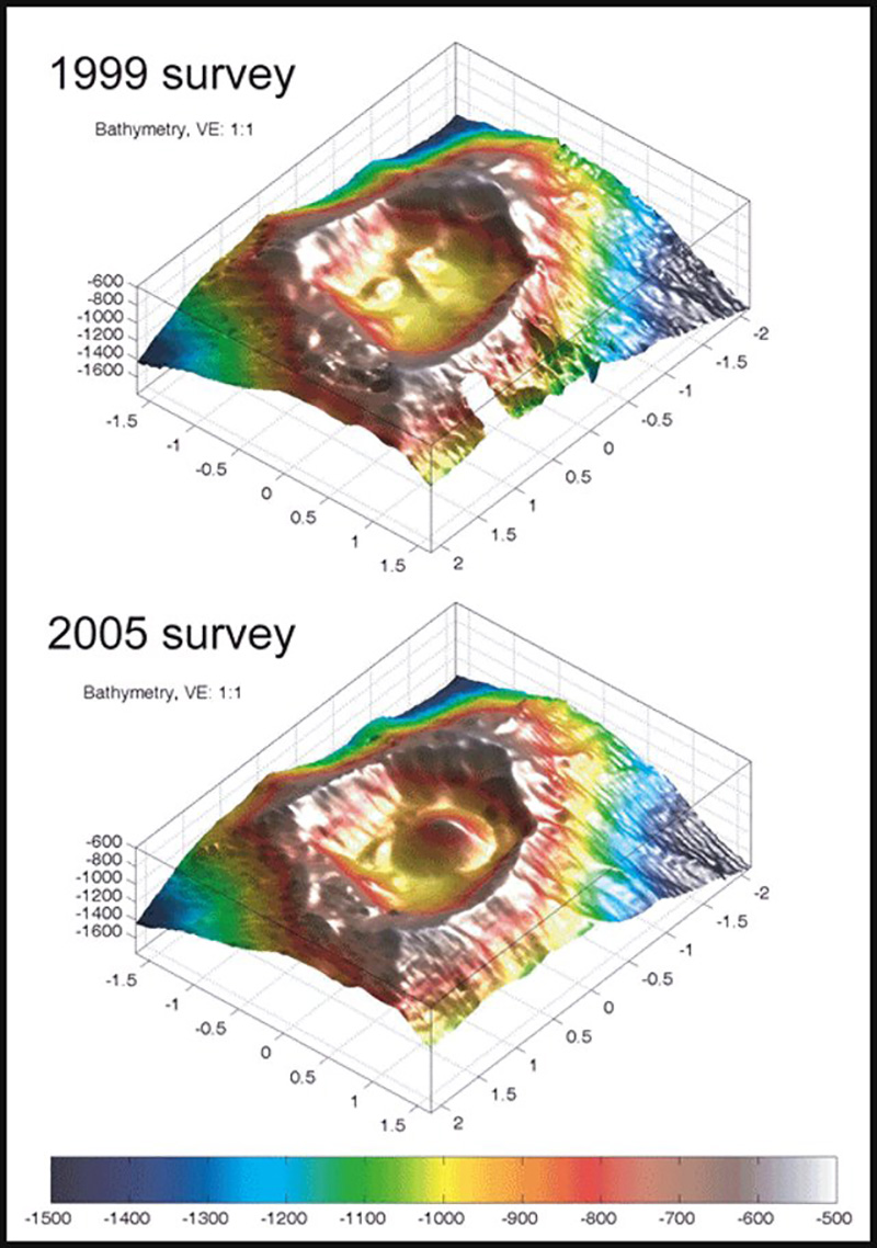 |
Figure 7. Bathymetry of the Vailuluʻu crater between the 1999 and 2005 surveys, showing the emergence of Nafanua. Courtesy of H. Staudigel and S. Hart. |
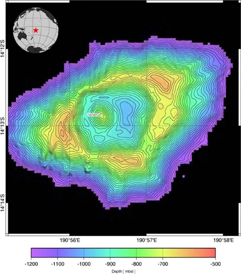 |
Figure 8. Bathymetric map of the Vailuluʻu seamount from multibeam data during the April 2005 survey. Note the new inner cone named Nafanua. Contour interval is 20 m. Courtesy of H. Staudigel and S. Hart. |
Seismic monitoring during April-June 2000 showed substantial seismicity, ~ 4 earthquakes per day with hypocenters beneath Nafanua (Konter and others, 2004; BGVN 26:06), which can now be interpreted as pre-eruption seismic activity. These observations are consistent with previous reports highlighting the volcanic and hydrothermal activity of Vailuluʻu (Hart and others, 2000; Staudigel and others, 2004). The scientists suggested that continued volcanic activity could bring the summit region of Vailuluʻu to a water depth of ~ 200 m. At that point, Nafanua would overtop the crater rim and further growth would require a build-up of the lower flanks, areas that rise from the 5,000-m-deep floor of the ocean.
Staudigel and Hart teamed up in April 2005 on the Hawaiian Research Vessel Kilo Moana to study the Samoan hotspot thought to underlie Vailuluʻu. They named their expedition ALIA after the ancient twin-hulled canoe that Samoan warriors used to explore the SW Pacific. The Kilo Moana left Pago Pago on 4 April 2005 to study active and extinct underwater volcanoes along the chain of Samoan islands. The expedition investigated previously uncharted seamounts and the submarine portions of some islands, scattered over almost 600 nautical miles, from its most recent and quite active Vailuluʻu submarine volcano in the E to Combe Island in the W.
The Nafanua cone was first mapped by using the center beam of the research vessel KOK in several crossings of the W crater. An active hydrothermal system was apparent from evidence such as the murky water that limited visibility during two submersible dives, several microbial biomats covering pillow lavas that were centimeters thick, and a large number of diffuse vents. A dive on 30 March 2005 to examine Nafanua reported "that it must have grown in the last 4 years because CTD (conductivity-temperature-depth) crossings in 2001 still were consistent with the old crater morphology ... the basal portion of the cone displayed relatively large pillows, and higher up pillows look almost like very fluid pāhoehoe that collapsed and/or transitioned into ʻāʻā flows. Nafanua . . . grew very fast with abundant breccia material from collapsing and draining pillows, in particular in the summit region."
On 1 April, another dive along the outer flanks of Vailuluʻu found that during the up-slope transit, observers saw a few additional areas of active venting and many sites where there had been venting in the past. Large and perfectly formed pillow lavas were present in most sites, with a few areas being dominated by broken talus fragments and some having completely black glassy pillows with no oxidation, apparent evidence for relatively recent formation. The topography was extremely rough, the slope being punctuated with numerous fissure systems and edifices of pillow lava.
A primary plan for the ALIA expedition was to study the water in and around the seamount for several days using a CTD probe. To sample the inside of the volcano for a full tidal cycle, the scientists varied the depth of the CTD between 40 and 930 m (almost to the crater floor), collecting various data, including visibility. At Vailuluʻu, the particulates given off by hydrothermal venting are flushed out of its caldera during each tidal cycle into the surrounding water. In 2005, a dense layer of particulates was found in the water within the crater, but the water was clear outside the crater rim. This contrasts with observations seen from the cruise in 2000, when there was a dense ring of particulates around the whole volcano. It appears that in 2005 the particulates were rising above the crater and then later sinking, instead of forming the widespread ring observed in 2000.
In addition, the expedition crew conducted dredging of the new summit of Nafanua. Staudigel and Hart noted that the rocks from the first dredge haul were quite newly formed, containing pristine olivine-phyric volcanic rocks. Abundant large vesicles in the rocks from Nafanua suggest a volatile-rich magma capable of submarine lava fountaining and explosive outgassing in shallower water. Dredging from a second site, outside of Vailuluʻu, recovered rocks that were both much older and far less fragile.
References. Hart, S.R., Staudigel, H., Koppers, A.A.P., Blusztajn, J., Baker, E.T., Workman, R., Jackson, M., Hauri, E., Kurz, M., Sims, K., Fornari, D., Saal, A., and Lyons, S., 2000, Vailuluʻu undersea volcano: The new Samoa: Geochemistry, Geophysics, Geosystems (G3), American Geophysical Union, v. 1, no. 12, doi: 10.1029/2000GC000108.
Konter, J.G., Staudigel, H., Hart, S.R., and Shearer, P.M., 2004, Seafloor seismic monitoring of an active submarine volcano: Local seismicity at Vailuluʻu Seamount, Samoa: Geochemistry, Geophysics, Geosystems (G3), American Geophysical Union, v. 5, no. 6, QO6007, doi: 10.1029/2004GC000702.
Lippsett, L., 2002, Voyage to Vailuluʻu: Searching for Underwater Volcanoes. Woods Hole Oceanographic Institution, Fathom online magazine (URL: http://www.fathom.com/feature/122477/).
Staudigel, H., Hart, S.R., Koppers, A., Constable, C., Workman, R., Kurz, M., and Baker, E.T., 2004, Hydrothermal venting at Vailuluʻu Seamount: The smoking end of the Samoan chain: Geochemistry, Geophysics, Geosystems (G3), American Geophysical Union, v. 5, no. 2, QO2003, doi: 10.1029/2003GC000626.
Information Contacts: Hubert Staudigel, Institute of Geophysics and Planetary Physics, Scripps Institution of Oceanography, Univ. of California, San Diego, La Jolla, CA 92093-0225, USA (URL: https://earthref.org/whoswho/ER/hstaudigel/, https://igpp.ucsd.edu/); Stanley R. Hart, Woods Holes Oceanographic Institute, Geology and Geophysics Dept., Woods Hole, MA 02543, USA; ALIA Expedition, Samoan Seamounts, R/V Kilo Moana (KM0506), supported by the San Diego Supercomputer Center and the Scripps Institution of Oceanography (URL: https://earthref.org/ERESE/projects/ALIA/).
The Global Volcanism Program has no Weekly Reports available for Vailulu'u.
Reports are organized chronologically and indexed below by Month/Year (Publication Volume:Number), and include a one-line summary. Click on the index link or scroll down to read the reports.
01/1995 (BGVN 20:01) T-waves detected from eastern Samoa Islands area
02/1995 (BGVN 20:02) Seismicity ends after 145 events detected by T-waves
06/2001 (BGVN 26:06) Description of submarine volcano at the end of the Samoan chain
04/2005 (BGVN 30:04) ALIA cruise discloses new cone in the summit crater
Information is preliminary and subject to change. All times are local (unless otherwise noted)
Cite this Report
T-waves detected from eastern Samoa Islands area
The RSP stations on Tahiti, Rangiroa, Tubuai, and Rikitea registered acoustic T-waves beginning at 1700 on 8 January from a seismic swarm that, estimated from T-wave arrivals, was centered in the vicinity of the E Samoa Islands. Small events continued until 1600 on 9 January, but became stronger after 1645. Between 1645 on 9 January and 13 January, 54 small events and 28 stronger events were detected. The largest event occurred at 1407 on 10 January and was detected at all the RSP stations. Signals continued through January at a rate of two or more each day. During 8-31 January there were 91 small events and 40 stronger events. The world-wide seismic network detected 12 events (M 4.2-4.8) in this area during 9-20 January (table 1 and figure 1). T-wave arrival times in Tahiti (data available through 13 January) showed a consistent 23-24 minute delay for these events.
Table 1. Earthquakes detected and located by the World-Wide Seismic Network, 9-20 January 1995, near Taʻu Island. T-wave arrival times in Tahiti are consistently 23-24 minutes later than the event UTC time. Data courtesy of the USGS National Earthquake Information Center and LDG Tahiti.
| Date | UTC Time | T-wave Arrival | Latitude | Longitude | Magnitude (mb) | Stations | Comments |
| 09 Jan 1995 | 2301 | 2324 | 13.95°S | 169.37°W | 4.4 | 15 | -- |
| 10 Jan 1995 | 1343 | 1407 | 14.26°S | 169.06°W | 4.8 | 22 | -- |
| 11 Jan 1995 | 1540 | 1603 | 14.23°S | 168.78°W | 4.5 | 21 | E of map |
| 12 Jan 1995 | 0530 | 0554 | 13.90°S | 169.24°W | 4.6 | 22 | -- |
| 12 Jan 1995 | 1720 | 1744 | 13.95°S | 169.25°W | 4.7 | 15 | -- |
| 12 Jan 1995 | 1955 | 2018 | 13.35°S | 169.56°W | 4.5 | 31 | NW of map |
| 12 Jan 1995 | 2335 | 2358 | 13.72°S | 169.38°W | 4.7 | 14 | -- |
| 13 Jan 1995 | 0220 | 0243 | 13.41°S | 169.61°W | 4.5 | 28 | NW of map |
| 13 Jan 1995 | 0454 | 0517 | 14.01°S | 169.19°W | 4.4 | 23 | -- |
| 18 Jan 1995 | 0654 | -- | 13.82°S | 169.21°W | 4.2 | 9 | T-wave data unknown |
| 18 Jan 1995 | 1019 | -- | 14.02°S | 169.08°W | 4.2 | 12 | T-wave data unknown |
| 20 Jan 1995 | 1120 | -- | 13.72°S | 169.41°W | 4.8 | 19 | T-wave data unknown |
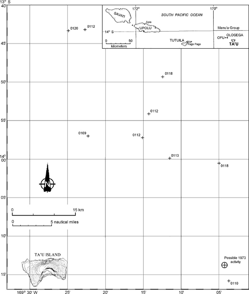 |
Figure 1. Map showing locations of nine earthquakes NE of Taʻu Island, Samoa, during January 1995. Hypocenters are labeled with the date (0112 = 12 January) of the event. Two located events not shown plot farther NW, and one to the E of the map area (see table 1). Index map modified from Stice and McCoy (1968). |
RSP seismologists believe that the swarm was volcanic because the signals are similar to the classic Monowai and Raoul T-waves: short-duration and impulsive. Submarine eruptions at Monowai Seamount were detected by T-wave signals in 1986, 1988, and 1990-91 (SEAN 13:09, BGVN 15:09, and BGVN 16:03). The stronger events in this swarm were the same amplitude as normal Monowai or Raoul T-wave signals. T-waves produced by earthquakes have much longer durations and are not impulsive. Also, this area is not seismically active; one small event was recorded in 1969 and another in 1976 (M 5.0).
The Manuʻa Islands (Taʻu, Ofu, and Olosega) were built by volcanic activity along the crest of the easternmost portion of the Samoa Ridge (Stice and McCoy, 1968). This earthquake swarm was centered ~50 km NE of Taʻu Island, the emergent portion of the large Lata shield volcano; numerous Holocene post-caldera cones occur at the summit and on the flanks of this volcano. Ofu and Olosega islands, NW of Taʻu, are formed by two eroded coalescing shield volcanoes. A submarine eruption along the ridge between Olosega and Taʻu islands, ~3 km SE of the tip of Olosega Island, was reported from 12 September to the middle of November 1866. A possible submarine eruption E of Taʻu was detected by SOFAR in July 1973.
Reference. Stice, G.D., and McCoy, F.W., Jr., 1968, The geology of the Manuʻa Islands, Samoa: Pacific Science, v. 22, p. 427-457.
Information Contacts: Francois Schindele, Laboratoire de Geophysique (LDG), B.P. 640, Papeete, Tahiti, Polynesie, France; National Earthquake Information Center (NEIC), U.S. Geological Survey.
Cite this Report
Seismicity ends after 145 events detected by T-waves
The RSP stations in Tahiti registered acoustic T-waves (tertiary waves traveling through the ocean) beginning on 8 January. This seismic swarm ended after 9 small and 5 stronger events in early February. The total number of recorded events during this swarm was 100 small and 45 larger events. Twelve of the larger events in January (M 4.2-4.8), detected and located by the world-wide seismic network, showed that the swarm was spread ~130 km along a NW-SE trend,~50 km NE of Taʻu Island (see figure 1) in the E Samoa Islands.
Information Contacts: F. Schindele, LDG, Tahiti; NEIC.
Cite this Report
Description of submarine volcano at the end of the Samoan chain
Recent work by Hart and others (2000) has described this volcano and identified it as the source of acoustic signals noted in July 1973 and an earthquake swarm during January 1995 (BGVN 20:01 and 20:02). The following is from Hart and others (2000) except where noted.
Vailuluʻu Seamount is located 45 km east of Taʻu island, the easternmost island of the Samoan chain, and defines the leading edge of the Samoan swell (figure 2). Mapped in March 1999 with SeaBeam aboard the RV Melville during AVON cruises 2 and 3 (figures 2 and 3), Vailuluʻu rises from an ocean depth of 4,800 m to its crater rim within 590 m of the sea surface, with a total volume of ~1,050 km3. The summit includes a 400-m-deep, 2-km-wide crater (figure 4). These cruises were motivated by the 1973 and 1995 acoustic and seismic events in this region, and were a direct attempt to find the current location of the Samoan hotspot.
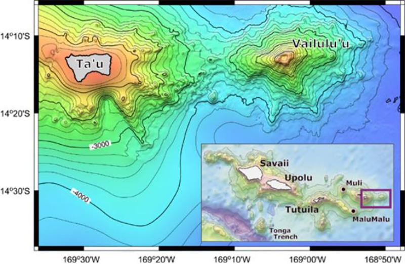 |
Figure 2. Bathymetry of Vailuluʻu and nearby Taʻu Island, based on a SeaBeam bathymetric survey performed during R/V Melville's AVON 2 and 3 cruises, augmented with satellite-derived bathymetry from Smith and Sandwell (1996). The inset shows the general location of Vailuluʻu with respect to the Samoan Archipelago; two other newly mapped and dredged seamounts (Malumalu and Muli, AVON 3 cruise) are shown as well. Scale: 10' = 18 km. From Hart and others (2000). |
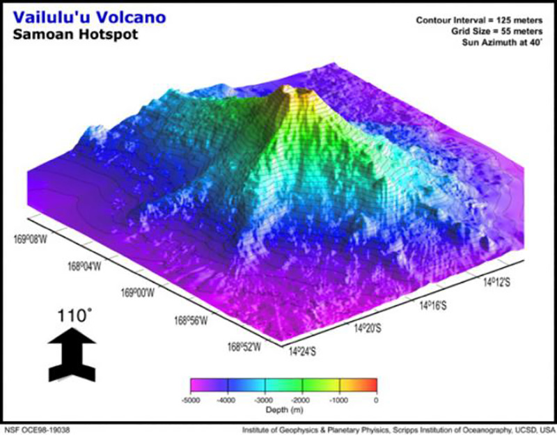 |
Figure 3. Perspective view of Vailuluʻu seamount looking NW, displaying three major rifts toward the E, SE, and W. The lower slopes of Vailuluʻu and Taʻu merge along the western ridge, with a saddle at 3,200 m. Vailuluʻu is ~ 35 km in diameter at its base. Scale: 10' = 18 km. From Hart and others (2000). |
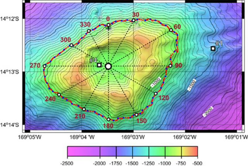 |
Figure 4. SeaBeam bathymetry map of the summit crater of Vailuluʻu, showing the crater rim with three peaks and three breaches, the location of CTDO (conductivity, temperature, depth, optical) casts 1 and 4, and the tow-yo track circumnavigated around the summit. Dotted azimuth lines are given every 30° along the track. Scale: 1' = 1.8 km. From Hart and others (2000). |
The overall shape of Vailuluʻu is dominated by two rift zones extending E and W from the summit, defining a lineament parallel to the Samoan hotspot track. A third, slightly less well-developed rift extends SE from the summit, and several minor ridges extend out from the lower slopes, making an overall asymmetric, star-like pattern. Rift zones and ridges in the southern sector are more strongly developed than those on the N flank, giving Vailuluʻu a stunning similarity to a juvenile Taʻu island (figure 2). The three major rift zones define three high points of the crater rim. The crater and rim are oval-shaped (figure 3), with two well-developed pit craters defining the northern two-thirds of the crater and two minor depressions on a bench in the southern third of the crater.
Several historical events suggest volcanic activity. There was a series of acoustically detected explosions on 10 July 1973 (Johnson, 1984), and during 9-29 January 1995 the global seismic network recorded a strong (M 4.2-4.9) earthquake swarm in the vicinity (BGVN 20:01 and 20:02). While most of the 1995 earthquakes were formally located NW of the volcano, their uncertainty ellipses include Vailuluʻu; a SeaBeam survey within the apparent earthquake area did not reveal any volcano-tectonic features. Dredges, especially those from the summit area, are dominated by fresh volcanic rock, with pristine volcanic glass, many original glassy surfaces, unaltered olivine phenocrysts, and a virtual lack of vesicle fillings. Extremely "bright" SeaBeam sidescan returns suggest that fresh volcanic rocks occur ubiquitously throughout the slopes of Vailuluʻu and that sediment cover is largely absent.
A detailed nephelometry survey of the water column shows clear evidence for hydrothermal plume activity in the summit crater. The water inside the crater is very turbid, and a halo of "smog" several hundred meters thick encircles and extends away from the summit for at least 7 km (see Hart and others, 2000, for details).
During the DeepFreeze 2000 cruise in March 2000, aboard the U.S. Coast Guard Icebreaker Polar Star, conductivity temperature depth optical (CTDO)/Niskin stations were occupied at three places within the summit crater and two outside the crater; in addition, the summit area was circumnavigated in tow-yo mode along the ~1,000-m contour (figure 4). Particulate distribution in the water column was studied using a light backscattering sensor (LBSS) attached to a CTD/Niskin water sampling rosette. At 600-m depth in the crater turbidity increased sharply and continued to do so in a stepwise fashion to the bottom of the crater at 996 m. Turbidity near the bottom was greater than that associated with active venting and plume formation on ridge crests. At station 1, outside the crater, the LBSS "smog" layer starts at about the same depth (610 m) but returns to background values at 850 m. This depth interval is comparable to the elevation range of the crater rim, which has peaks at 590 m and a deepest breach at ~780 m (figure 4). At station 5, 7.5 km E of the crater rim, a small turbidity anomaly was observed at a depth of 600-720 m.
During a complete 360° circumnavigation of the summit crater, the plume was mapped from 500 to 900 m depth in tow-yo mode (figure 4). Overall, the hydrothermal plume was confined to a narrow depth interval bracketed between the breaches and summits of the crater wall. Its upper, neutral buoyancy, level corresponds closely with the heights of the peaks on the crater rim. Virtually no particulate matter appears to be ejected from the crater to heights above the peaks on the crater rim nor does any settle below the breach depth during its dispersion laterally away from the summit. Particulates are being generated within the crater and are subsequently carried away by ocean currents.
Vailuluʻu is clearly a young and active submarine volcano. Its activity is reflected in acoustic/seismic events in 1973 and 1995, the lack of any sediment cover, fresh basalt and pristine glass in dredges from all levels, and radiometric ages ranging from 5 to 50 years. The summit is marked by a sharply delineated crater over 400 m deep, filled with highly turbid water. This smog layer extends out as a halo for many kilometers in all directions, in a narrow depth interval defined by the range in depths of the rim of the summit crater.
During another cruise to Vailuluʻu in April 2001, on the USCG Icebreaker Polar Sea, Hart and colleagues retrieved five hydrophones and temperature loggers that had been deployed the year before. A lot of minor seismic activity was still occurring, but detailed analyses have not been completed. The crater was still full of "smog," indicating that the crater remains hydrothermally active.
Previous work by Rockne Johnson. This seamount was discovered on 18 October 1975 by Rockne Johnson (Johnson, 1984) using an echosounder and a proton magnetometer aboard the 19-m ketch Kawamee while searching for the source of explosions detected on 10 July 1973. Those explosions, 26 within a 30-minute period, were identified in records from SOFAR (sound-fixing and ranging) stations at Wake and Midway Islands. The signals were calculated to have been from a source along a line that fell 15 km E of Taʻu Island, and were distinct from signals recorded a few hours later caused by a submarine eruption south of Curacao Reef 500 km W at the north end of the Tonga Ridge (CSLP Cards 1679, 1685, and 1694). Depths near 600 m were found around the summit, and a large magnetic anomaly was centered 4 km NW of the summit. Johnson (1984) believed that the seamount, which he named "Rockne Volcano," was the most likely source for the July 1973 activity, but noted that there was some doubt because of its distance from the line of position calculated from the acoustic data.
Selection of a volcano name. As reported by the Samoa News, the Samoa Department of Education's Science Department held a "Name that Volcano" contest in the high schools to come up with a permanent name for this volcano. Previously the volcano had been catalogued as "Unnamed" (Simkin and Siebert, 1994), and named "Rockne" (Johnson, 1984) and "Fa'afafine" (Hart and others, 1999). Woods Hole Oceanographic Institution scientist Stan Hart urged that the name endorsed by American Samoa be adopted by the scientific community. The winning entry, announced on 8 May 2000, came from Taulealo Vaofusi, a sophomore at Samoana High School. "Because of the location of the volcano being very close to the Manuʻa Islands village of Taʻu," Vaofusi explained to the Samoa News, "I would like to rename that volcano 'Vailuluʻu Volcano.' According to legend, Vailuluʻu was the sacred sprinkling of gentle rain that fell just before the gatherings of the great King TuiManuʻa. The Manuʻa group is also call the sacred islands or the Motu Sa, and the name 'Vailuluʻu' is given to the fountain owned by King TuiManuʻa," said Vaofusi in his entry form.
References. Hart, S.R., Staudigel, H., Koppers, A.A.P, Blusztajn, J., Baker, E.T., Workman, R., Jackson, M., Hauri, E., Kurz, M., Sims, K., Fornari, D., Saal., A., and Lyons, S., 2000, Vailuluʻu undersea volcano: The New Samoa: Geochemistry, Geophysics, Geosystems (G3), American Geophysical Union, v. 1, December 8, 2000.
Hart, S.R., Staudigel, H., Kurz, M.D., Blusztajn, J., Workman, R., Saal, A., Koppers, A., Hauri, E.H., and Lyons, S., 1999, Fa'afafine volcano: The active Samoan hotspot: EOS Transactions, American Geophysical Union, v. 80, 1999 Fall Meeting Supplement, p. F1102.
Johnson, R.H., 1984, Exploration of three submarine volcanos in the South Pacific: National Geographic Society Research Reports, National Geographic Society, v. 16, p. 405-420.
Simkin, T., and Siebert, L., 1994, Volcanoes of the World, 2nd edition: Geoscience Press in association with the Smithsonian Institution Global Volcanism Program, Tucson AZ, 368 p.
Smith, W.H.F., and Sandwell, D., 1996, Predicted bathymetry, new global seafloor topography from satellite altimetry: EOS Transactions, American Geophysical Union, v. 77, no. 46, p. 315.
Stice, G.D., and McCoy, F.W., Jr., 1968, The geology of the Manuʻa Islands, Samoa: Pacific Science, v. 22, p. 427-457.
Information Contacts: Stanley R. Hart, Woods Hole Oceanographic Institution, Woods Hole, MA 02543 USA (URL: http://www.whoi.edu/); Samoa News, P.O. Box 909, Pago Pago, AS 96799 (URL: http://www.samoanews.com/).
Cite this Report
ALIA cruise discloses new cone in the summit crater
According to Hubert Staudigel (Scripps Institution of Oceanography) and Stanley Hart (Woods Hole Oceanographic Institute), Vailuluʻu seamount, the most active Samoan submarine volcano, erupted between April 2001 and April 2005. It formed a 293-m-tall lava cone, which was named Nafanua after the Samoan Goddess of War. This new cone had been growing inside the 2-km-wide caldera of Vailuluʻu at a minimum rate of about 20 cm/day since April 2001. Nafanua was discovered during a 2005 diving expedition with the National Oceanic and Atmospheric Agency (NOAA) research submersible Pisces V, launched from the University of Hawaii research vessel Kaimikai O Kanaloa (KOK). It is located in the originally 1,000-m-deep W crater of Vailuluʻu (figures 5 to 8).
|
Figure 5. The route of the 2005 cruise of the research vessel Kilo Moana. Vailuluʻu, towards the E end of the Samoan hotspot trail was visited on cruise days 1-4, 4-8 April 2005. Courtesy of H. Staudigel and S. Hart. |
|
Figure 6. Bathymetry of Vailuluʻu and nearby Taʻu Island, based on a SeaBeam bathymetric survey performed during R/V Melville's AVON 2 and 3 cruises, augmented with satellite-derived bathymetry from Smith and Sandwell (1996). The inset shows the general location of Vailuluʻu with respect to the Samoan Archipelago; two other newly mapped and dredged seamounts (Malumalu and Muli, AVON 3 cruise) are shown as well. Scale: 10' = 18 km. From Hart and others (2000). |
|
Figure 7. Bathymetry of the Vailuluʻu crater between the 1999 and 2005 surveys, showing the emergence of Nafanua. Courtesy of H. Staudigel and S. Hart. |
|
Figure 8. Bathymetric map of the Vailuluʻu seamount from multibeam data during the April 2005 survey. Note the new inner cone named Nafanua. Contour interval is 20 m. Courtesy of H. Staudigel and S. Hart. |
Seismic monitoring during April-June 2000 showed substantial seismicity, ~ 4 earthquakes per day with hypocenters beneath Nafanua (Konter and others, 2004; BGVN 26:06), which can now be interpreted as pre-eruption seismic activity. These observations are consistent with previous reports highlighting the volcanic and hydrothermal activity of Vailuluʻu (Hart and others, 2000; Staudigel and others, 2004). The scientists suggested that continued volcanic activity could bring the summit region of Vailuluʻu to a water depth of ~ 200 m. At that point, Nafanua would overtop the crater rim and further growth would require a build-up of the lower flanks, areas that rise from the 5,000-m-deep floor of the ocean.
Staudigel and Hart teamed up in April 2005 on the Hawaiian Research Vessel Kilo Moana to study the Samoan hotspot thought to underlie Vailuluʻu. They named their expedition ALIA after the ancient twin-hulled canoe that Samoan warriors used to explore the SW Pacific. The Kilo Moana left Pago Pago on 4 April 2005 to study active and extinct underwater volcanoes along the chain of Samoan islands. The expedition investigated previously uncharted seamounts and the submarine portions of some islands, scattered over almost 600 nautical miles, from its most recent and quite active Vailuluʻu submarine volcano in the E to Combe Island in the W.
The Nafanua cone was first mapped by using the center beam of the research vessel KOK in several crossings of the W crater. An active hydrothermal system was apparent from evidence such as the murky water that limited visibility during two submersible dives, several microbial biomats covering pillow lavas that were centimeters thick, and a large number of diffuse vents. A dive on 30 March 2005 to examine Nafanua reported "that it must have grown in the last 4 years because CTD (conductivity-temperature-depth) crossings in 2001 still were consistent with the old crater morphology ... the basal portion of the cone displayed relatively large pillows, and higher up pillows look almost like very fluid pāhoehoe that collapsed and/or transitioned into ʻāʻā flows. Nafanua . . . grew very fast with abundant breccia material from collapsing and draining pillows, in particular in the summit region."
On 1 April, another dive along the outer flanks of Vailuluʻu found that during the up-slope transit, observers saw a few additional areas of active venting and many sites where there had been venting in the past. Large and perfectly formed pillow lavas were present in most sites, with a few areas being dominated by broken talus fragments and some having completely black glassy pillows with no oxidation, apparent evidence for relatively recent formation. The topography was extremely rough, the slope being punctuated with numerous fissure systems and edifices of pillow lava.
A primary plan for the ALIA expedition was to study the water in and around the seamount for several days using a CTD probe. To sample the inside of the volcano for a full tidal cycle, the scientists varied the depth of the CTD between 40 and 930 m (almost to the crater floor), collecting various data, including visibility. At Vailuluʻu, the particulates given off by hydrothermal venting are flushed out of its caldera during each tidal cycle into the surrounding water. In 2005, a dense layer of particulates was found in the water within the crater, but the water was clear outside the crater rim. This contrasts with observations seen from the cruise in 2000, when there was a dense ring of particulates around the whole volcano. It appears that in 2005 the particulates were rising above the crater and then later sinking, instead of forming the widespread ring observed in 2000.
In addition, the expedition crew conducted dredging of the new summit of Nafanua. Staudigel and Hart noted that the rocks from the first dredge haul were quite newly formed, containing pristine olivine-phyric volcanic rocks. Abundant large vesicles in the rocks from Nafanua suggest a volatile-rich magma capable of submarine lava fountaining and explosive outgassing in shallower water. Dredging from a second site, outside of Vailuluʻu, recovered rocks that were both much older and far less fragile.
References. Hart, S.R., Staudigel, H., Koppers, A.A.P., Blusztajn, J., Baker, E.T., Workman, R., Jackson, M., Hauri, E., Kurz, M., Sims, K., Fornari, D., Saal, A., and Lyons, S., 2000, Vailuluʻu undersea volcano: The new Samoa: Geochemistry, Geophysics, Geosystems (G3), American Geophysical Union, v. 1, no. 12, doi: 10.1029/2000GC000108.
Konter, J.G., Staudigel, H., Hart, S.R., and Shearer, P.M., 2004, Seafloor seismic monitoring of an active submarine volcano: Local seismicity at Vailuluʻu Seamount, Samoa: Geochemistry, Geophysics, Geosystems (G3), American Geophysical Union, v. 5, no. 6, QO6007, doi: 10.1029/2004GC000702.
Lippsett, L., 2002, Voyage to Vailuluʻu: Searching for Underwater Volcanoes. Woods Hole Oceanographic Institution, Fathom online magazine (URL: http://www.fathom.com/feature/122477/).
Staudigel, H., Hart, S.R., Koppers, A., Constable, C., Workman, R., Kurz, M., and Baker, E.T., 2004, Hydrothermal venting at Vailuluʻu Seamount: The smoking end of the Samoan chain: Geochemistry, Geophysics, Geosystems (G3), American Geophysical Union, v. 5, no. 2, QO2003, doi: 10.1029/2003GC000626.
Information Contacts: Hubert Staudigel, Institute of Geophysics and Planetary Physics, Scripps Institution of Oceanography, Univ. of California, San Diego, La Jolla, CA 92093-0225, USA (URL: https://earthref.org/whoswho/ER/hstaudigel/, https://igpp.ucsd.edu/); Stanley R. Hart, Woods Holes Oceanographic Institute, Geology and Geophysics Dept., Woods Hole, MA 02543, USA; ALIA Expedition, Samoan Seamounts, R/V Kilo Moana (KM0506), supported by the San Diego Supercomputer Center and the Scripps Institution of Oceanography (URL: https://earthref.org/ERESE/projects/ALIA/).
|
|
||||||||||||||||||||||||||
There is data available for 3 confirmed eruptive periods.
2003 Apr 16 ± 2 years ± 15 days Confirmed Eruption (Explosive / Effusive) VEI: 0
| Episode 1 | Eruption (Explosive / Effusive) | West side of caldera (Nafanua) | ||||||||||||||||||
|---|---|---|---|---|---|---|---|---|---|---|---|---|---|---|---|---|---|---|---|
| 2003 Apr 16 ± 2 years ± 15 days - Unknown | Evidence from Observations: Reported | ||||||||||||||||||
|
List of 2 Events for Episode 1 at West side of caldera (Nafanua)
|
|||||||||||||||||||
1995 Jan 9 - 1995 Jan 29 Confirmed Eruption (Explosive / Effusive) VEI: 0
| Episode 1 | Eruption (Explosive / Effusive) | ||||||||||||||||||||||||
|---|---|---|---|---|---|---|---|---|---|---|---|---|---|---|---|---|---|---|---|---|---|---|---|---|
| 1995 Jan 9 - 1995 Jan 29 | Evidence from Observations: Hydrophonic | |||||||||||||||||||||||
|
List of 3 Events for Episode 1
|
||||||||||||||||||||||||
1973 Jul 10 - 1973 Jul 10 Confirmed Eruption (Explosive / Effusive) VEI: 0
| Episode 1 | Eruption (Explosive / Effusive) | ||||||||||||||
|---|---|---|---|---|---|---|---|---|---|---|---|---|---|---|
| 1973 Jul 10 - 1973 Jul 10 | Evidence from Observations: Hydrophonic | |||||||||||||
|
List of 1 Events for Episode 1
|
||||||||||||||
This compilation of synonyms and subsidiary features may not be comprehensive. Features are organized into four major categories: Cones, Craters, Domes, and Thermal Features. Synonyms of features appear indented below the primary name. In some cases additional feature type, elevation, or location details are provided.
Synonyms |
||||
| Fa'afafine Seamount | Rockne Volcano | ||||
Cones |
||||
| Feature Name | Feature Type | Elevation | Latitude | Longitude |
| Nafanua | Lava cone | |||
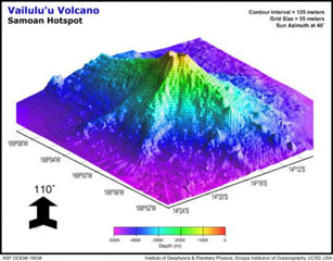 This view of Vailulu'u seamount to the NW displays three major rifts toward the W, SE, and W. The lower slopes of Vailulu'u and Ta'u merge along the W ridge, with a saddle at 3,200 m and a diameter of ~35 km at its base. An earthquake swarm in 1995 may have been related to an eruption at Vailulu'u, which was not discovered until 1975. It rises 4,200 m from the sea floor to a depth of about 600 m between Ta'u and Rose islands at the eastern end of the American Samoas.
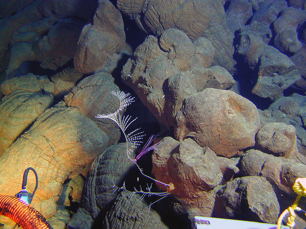
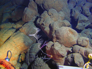 Pillow lavas on the western rift of Vailulu'u volcano with exotic marine life, photographed during a NOAA Ocean Explorer expedition in 2005. Two principal rift zones extend E and W from the summit of the submarine volcano, parallel to the trend of the Samoan hotspot. Not discovered until 1975, this seamount rises 4,200 m from the sea floor to a depth of about 600 m and displays evidence of hydrothermal venting.
There are no samples for Vailulu'u in the Smithsonian's NMNH Department of Mineral Sciences Rock and Ore collection.
| Copernicus Browser | The Copernicus Browser replaced the Sentinel Hub Playground browser in 2023, to provide access to Earth observation archives from the Copernicus Data Space Ecosystem, the main distribution platform for data from the EU Copernicus missions. |
| MIROVA | Middle InfraRed Observation of Volcanic Activity (MIROVA) is a near real time volcanic hot-spot detection system based on the analysis of MODIS (Moderate Resolution Imaging Spectroradiometer) data. In particular, MIROVA uses the Middle InfraRed Radiation (MIR), measured over target volcanoes, in order to detect, locate and measure the heat radiation sourced from volcanic activity. |
| MODVOLC Thermal Alerts | Using infrared satellite Moderate Resolution Imaging Spectroradiometer (MODIS) data, scientists at the Hawai'i Institute of Geophysics and Planetology, University of Hawai'i, developed an automated system called MODVOLC to map thermal hot-spots in near real time. For each MODIS image, the algorithm automatically scans each 1 km pixel within it to check for high-temperature hot-spots. When one is found the date, time, location, and intensity are recorded. MODIS looks at every square km of the Earth every 48 hours, once during the day and once during the night, and the presence of two MODIS sensors in space allows at least four hot-spot observations every two days. Each day updated global maps are compiled to display the locations of all hot spots detected in the previous 24 hours. There is a drop-down list with volcano names which allow users to 'zoom-in' and examine the distribution of hot-spots at a variety of spatial scales. |
|
WOVOdat
Single Volcano View Temporal Evolution of Unrest Side by Side Volcanoes |
WOVOdat is a database of volcanic unrest; instrumentally and visually recorded changes in seismicity, ground deformation, gas emission, and other parameters from their normal baselines. It is sponsored by the World Organization of Volcano Observatories (WOVO) and presently hosted at the Earth Observatory of Singapore.
GVMID Data on Volcano Monitoring Infrastructure The Global Volcano Monitoring Infrastructure Database GVMID, is aimed at documenting and improving capabilities of volcano monitoring from the ground and space. GVMID should provide a snapshot and baseline view of the techniques and instrumentation that are in place at various volcanoes, which can be use by volcano observatories as reference to setup new monitoring system or improving networks at a specific volcano. These data will allow identification of what monitoring gaps exist, which can be then targeted by remote sensing infrastructure and future instrument deployments. |
| Volcanic Hazard Maps | The IAVCEI Commission on Volcanic Hazards and Risk has a Volcanic Hazard Maps database designed to serve as a resource for hazard mappers (or other interested parties) to explore how common issues in hazard map development have been addressed at different volcanoes, in different countries, for different hazards, and for different intended audiences. In addition to the comprehensive, searchable Volcanic Hazard Maps Database, this website contains information about diversity of volcanic hazard maps, illustrated using examples from the database. This site is for educational purposes related to volcanic hazard maps. Hazard maps found on this website should not be used for emergency purposes. For the most recent, official hazard map for a particular volcano, please seek out the proper institutional authorities on the matter. |
| EarthScope Consortium SAGE seismic stations/networks | EarthScope Consortium operates the NSF Geodetic Facility for the Advancement of Geoscience (GAGE) and NSF Seismological Facility for the Advancement of Geoscience (SAGE). The linked map shows the location of seismic stations from all available networks (permanent or temporary) within a radius of 0.18° (about 20 km at mid-latitudes) from the given location of Vailulu'u. Users can customize a variety of filters and options in the left panel. Note that if there are no stations are known the map will default to show the entire world with a "No data matched request" error notice. |
| Large Eruptions of Vailulu'u | Information about large Quaternary eruptions (VEI >= 4) is cataloged in the Large Magnitude Explosive Volcanic Eruptions (LaMEVE) database of the Volcano Global Risk Identification and Analysis Project (VOGRIPA). |
| EarthChem | EarthChem develops and maintains databases, software, and services that support the preservation, discovery, access and analysis of geochemical data, and facilitate their integration with the broad array of other available earth science parameters. EarthChem is operated by a joint team of disciplinary scientists, data scientists, data managers and information technology developers who are part of the NSF-funded data facility Integrated Earth Data Applications (IEDA). IEDA is a collaborative effort of EarthChem and the Marine Geoscience Data System (MGDS). |

