On 31 August the Vanuatu Meteorology and Geohazards Department (VMGD) reported that activity at Suretamatai continued at a level of “minor unrest.” No notable volcanic emissions were identified in the most recent satellite data, though steam emissions from areas around the cone and the Sulphur River continued to be locally observed. The public was reminded that the danger zone was near the cone and the Sulphur River, though the risk to the public was low.
Source: Vanuatu Meteorology and Geohazards Department (VMGD)
Fumarolic activity
"During our survey, no change in activity at the major geothermal areas (Frenchman's Solfataras and Hell's Gate) was noted, with respect to descriptions by Aubert de la Rue (1937) and Hochstein (1980). Slightly superheated fumaroles (with sulfur deposits), hot springs, and boiling ponds up to 3 m in diameter occurred over a 300-m strip along the Sulfur River (E flank) between 300 to 400 m elevation. The temperature of the Sulfur River at Hell's Gate remained stable at 50°C.
"Soretimeat . . . is a composite volcano built on an ancient Pleistocene edifice. Ash emissions reported in 1860 and 1965-66 are most likely to have been from hydrothermal explosions (Ash and others, 1980)." ["Flames" were observed during an apparent eruption in 1865 (Atkin, 1868).]
References. Ash, R.P., Carney, J.N., and MacFarlane, A., 1980, Geology of the northern Banks Islands: New Hebrides Geological Survey Regional Report, p. 1-47.
Atkin, J., 1868, On volcanoes in the New Hebrides and Banks Islands: Proceedings of the Geological Society of London, v. 24, p. 305-307.
Aubert de la Rue, E., 1937, La Volcanisme aux Nouvelles Hebrides (Melanesie): BV, v. 2, p. 79-142.
Hochstein, M.P., 1980, Geology of the Northern Banks Islands: New Hebrides Geological Survey Regional Report, p. 47-49.
Information Contacts: C. Robin and M. Monzier, ORSTOM, Nouméa, New Caledonia; M. Lardy and C. Douglas, ORSTOM, Vanuatu; C. Mortimer, Dept. of Geology, Mines, and Rural Water Supply, Vanuatu; J. Eissen, ORSTOM, France.
On 31 August the Vanuatu Meteorology and Geohazards Department (VMGD) reported that activity at Suretamatai continued at a level of “minor unrest.” No notable volcanic emissions were identified in the most recent satellite data, though steam emissions from areas around the cone and the Sulphur River continued to be locally observed. The public was reminded that the danger zone was near the cone and the Sulphur River, though the risk to the public was low.
Source: Vanuatu Meteorology and Geohazards Department (VMGD)
On 27 May the Vanuatu Geohazards Observatory stated that the Alert Level for Suretamatai was increased to 1 (on a scale of 0-4) because of a change in activity. VGO reminded residents and tourists that areas around the volcano and along the Sulfur River (E flank) were high-risk zones due to potential impacts from volcanic gas emissions.
Source: Vanuatu Meteorology and Geohazards Department (VMGD)
Reports are organized chronologically and indexed below by Month/Year (Publication Volume:Number), and include a one-line summary. Click on the index link or scroll down to read the reports.
Fumarolic activity
"During our survey, no change in activity at the major geothermal areas (Frenchman's Solfataras and Hell's Gate) was noted, with respect to descriptions by Aubert de la Rue (1937) and Hochstein (1980). Slightly superheated fumaroles (with sulfur deposits), hot springs, and boiling ponds up to 3 m in diameter occurred over a 300-m strip along the Sulfur River (E flank) between 300 to 400 m elevation. The temperature of the Sulfur River at Hell's Gate remained stable at 50°C.
"Soretimeat . . . is a composite volcano built on an ancient Pleistocene edifice. Ash emissions reported in 1860 and 1965-66 are most likely to have been from hydrothermal explosions (Ash and others, 1980)." ["Flames" were observed during an apparent eruption in 1865 (Atkin, 1868).]
References. Ash, R.P., Carney, J.N., and MacFarlane, A., 1980, Geology of the northern Banks Islands: New Hebrides Geological Survey Regional Report, p. 1-47.
Atkin, J., 1868, On volcanoes in the New Hebrides and Banks Islands: Proceedings of the Geological Society of London, v. 24, p. 305-307.
Aubert de la Rue, E., 1937, La Volcanisme aux Nouvelles Hebrides (Melanesie): BV, v. 2, p. 79-142.
Hochstein, M.P., 1980, Geology of the Northern Banks Islands: New Hebrides Geological Survey Regional Report, p. 47-49.
Information Contacts: C. Robin and M. Monzier, ORSTOM, Nouméa, New Caledonia; M. Lardy and C. Douglas, ORSTOM, Vanuatu; C. Mortimer, Dept. of Geology, Mines, and Rural Water Supply, Vanuatu; J. Eissen, ORSTOM, France.
|
|
||||||||||||||||||||||||||
There is data available for 3 confirmed Holocene eruptive periods.
1965 Aug 9 - 1966 Jul 2 ± 182 days Confirmed Eruption (Explosive / Effusive) VEI: 2
| Episode 1 | Eruption (Explosive / Effusive) | NW flank | ||||||||||||||||||||||||||||||||||
|---|---|---|---|---|---|---|---|---|---|---|---|---|---|---|---|---|---|---|---|---|---|---|---|---|---|---|---|---|---|---|---|---|---|---|---|
| 1965 Aug 9 - 1966 Jul 2 ± 182 days | Evidence from Observations: Reported | ||||||||||||||||||||||||||||||||||
|
List of 5 Events for Episode 1 at NW flank
|
|||||||||||||||||||||||||||||||||||
1861 (?) Confirmed Eruption (Explosive / Effusive) VEI: 2
| Episode 1 | Eruption (Explosive / Effusive) | |||||||||||||||||||||||||
|---|---|---|---|---|---|---|---|---|---|---|---|---|---|---|---|---|---|---|---|---|---|---|---|---|---|
| 1861 (?) - Unknown | Evidence from Observations: Reported | ||||||||||||||||||||||||
|
List of 3 Events for Episode 1
|
|||||||||||||||||||||||||
1856 (?) Confirmed Eruption (Explosive / Effusive) VEI: 2 (?)
| Episode 1 | Eruption (Explosive / Effusive) | |||||||||||||||||||||||||
|---|---|---|---|---|---|---|---|---|---|---|---|---|---|---|---|---|---|---|---|---|---|---|---|---|---|
| 1856 (?) - Unknown | Evidence from Observations: Reported | ||||||||||||||||||||||||
|
List of 3 Events for Episode 1
|
|||||||||||||||||||||||||
[ 1841 ] Uncertain Eruption
| Episode 1 | Eruption (Explosive / Effusive) | ||||
|---|---|---|---|---|
| 1841 - Unknown | Evidence from Unknown | |||
This compilation of synonyms and subsidiary features may not be comprehensive. Features are organized into four major categories: Cones, Craters, Domes, and Thermal Features. Synonyms of features appear indented below the primary name. In some cases additional feature type, elevation, or location details are provided.
Synonyms |
||||
| Vanua Lava | Soritimeat | Seretmat | Suretametai | Souretamati | ||||
Cones |
||||
| Feature Name | Feature Type | Elevation | Latitude | Longitude |
| Amor | Stratovolcano | 296 m | 13° 53' 0.00" S | 167° 33' 0.00" E |
| Ghentolug | Stratovolcano | 309 m | 13° 53' 0.00" S | 167° 34' 0.00" E |
| Kwitintog | Stratovolcano | 541 m | 13° 52' 0.00" S | 167° 31' 0.00" E |
| Liserser | Stratovolcano | 620 m | 13° 53' 0.00" S | 167° 31' 0.00" E |
| Ngere Kwon | Stratovolcano | 817 m | 13° 57' 0.00" S | 167° 27' 0.00" E |
| Ow Rig | Stratovolcano | 753 m | 13° 47' 0.00" S | 167° 30' 0.00" E |
| Ow Sorlav-Ow Planmen | Stratovolcano | 798 m | 13° 45' 0.00" S | 167° 30' 0.00" E |
| Tow Alesere | Stratovolcano | 531 m | 13° 53' 0.00" S | 167° 29' 0.00" E |
| Tow Lav
Tolav |
Stratovolcano | 946 m | 13° 52' 0.00" S | 167° 30' 0.00" E |
| Tow Vetam | Stratovolcano | 459 m | 13° 52' 0.00" S | 167° 27' 0.00" E |
| Towawasag | Stratovolcano | 310 m | 13° 54' 0.00" S | 167° 30' 0.00" E |
| Towon Gar | Stratovolcano | 13° 56' 0.00" S | 167° 27' 0.00" E | |
| Ule'eg | Stratovolcano | 595 m | 13° 53' 0.00" S | 167° 25' 0.00" E |
| Uvera'a | Stratovolcano | 13° 52' 0.00" S | 167° 24' 0.00" E | |
Craters |
||||
| Feature Name | Feature Type | Elevation | Latitude | Longitude |
| Gemelkeret | Crater | 806 m | 13° 49' 0.00" S | 167° 27' 0.00" E |
| Konwonsavaro | Crater | 730 m | 13° 47' 0.00" S | 167° 28' 0.00" E |
| Orir | Crater | 13° 45' 0.00" S | 167° 28' 0.00" E | |
| Tow Maravrig | Crater | 603 m | 13° 51' 0.00" S | 167° 27' 0.00" E |
| Tow Markong | Crater | 13° 50' 0.00" S | 167° 28' 0.00" E | |
| Tow Mear | Crater | 722 m | 13° 50' 0.00" S | 167° 27' 0.00" E |
| Wensaoro | Crater | 585 m | 13° 47' 0.00" S | 167° 29' 0.00" E |
Thermal |
||||
| Feature Name | Feature Type | Elevation | Latitude | Longitude |
| Frenchmen's Solfatara | Fumarole | 400 m | 13° 48' 0.00" S | 167° 29' 0.00" E |
| Hell's Gate | Thermal | |||
| Nereuantop | Thermal | 400 m | 13° 48' 0.00" S | 167° 29' 0.00" E |
| Whitford's Solfatara | Fumarole | 13° 48' 0.00" S | 167° 28' 0.00" E | |
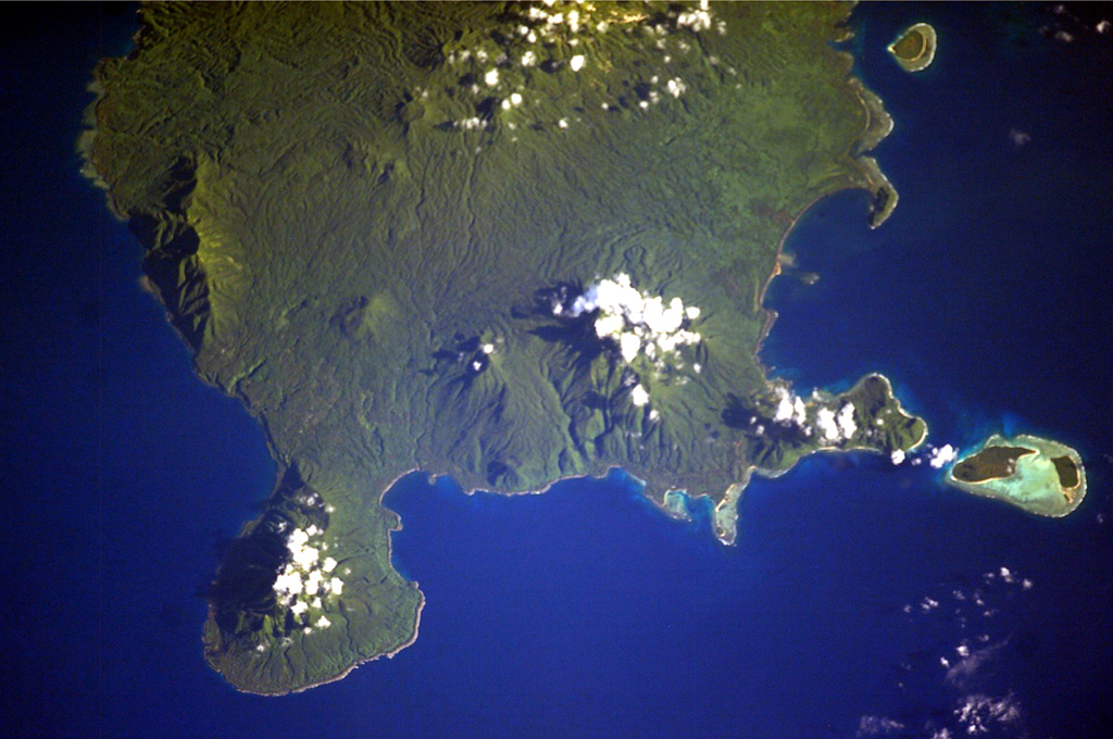
 The southern two-thirds of Vanua Lava Island is seen in this NASA International Space Station image. Suretamatai volcano forms much of the island, with the most recent activity occurring in the northern part of the island near the area with small clouds at the top of the image. The Pleistocene Ngéré Kwon volcano forms the peninsula at the bottom of the image, and small offshore islands to the right are uplifted reef limestones. Activity that began during the 19th century has consisted of moderate explosive eruptions.
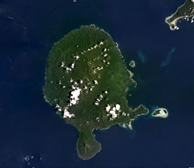 Vanua Lava Island of Vanuatu is shown in this February 2018 Planet Labs satellite image monthly mosaic (N is at the top; this image is approximately 40 km across). The majority of cones, craters, and features are in the northern part of the island, and comprise the Surematai volcano. The Pleistocene Ngere Kwon volcano formed the southernmost peninsula.
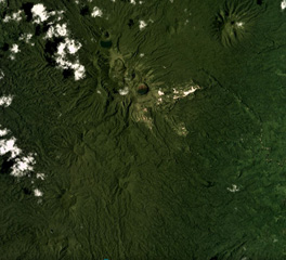 Craters and cones of Suretamatai in Vanua Lava Island, Vanuatu, are visible across this February 2018 Planet Labs satellite image monthly mosaic (N is at the top; this image is approximately 10 km across). The field covers much of the island, with a NNE-SSW trend of cones (shown here), with the largest edifice towards the northern end having formed multiple craters along a NW-SE trend. Geothermal activity continues.
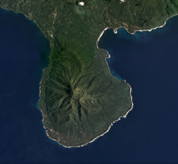 The 5-km-wide southern peninsula of Vanua Lava Island, Vanuatu, is seen in this 2018 Planet Labs satellite image monthly mosaic (N is at the top). The Pleistocene Ngere Kwon volcano formed this area, which has since been deeply eroded.
There are no samples for Suretamatai in the Smithsonian's NMNH Department of Mineral Sciences Rock and Ore collection.
| Copernicus Browser | The Copernicus Browser replaced the Sentinel Hub Playground browser in 2023, to provide access to Earth observation archives from the Copernicus Data Space Ecosystem, the main distribution platform for data from the EU Copernicus missions. |
| MIROVA | Middle InfraRed Observation of Volcanic Activity (MIROVA) is a near real time volcanic hot-spot detection system based on the analysis of MODIS (Moderate Resolution Imaging Spectroradiometer) data. In particular, MIROVA uses the Middle InfraRed Radiation (MIR), measured over target volcanoes, in order to detect, locate and measure the heat radiation sourced from volcanic activity. |
| MODVOLC Thermal Alerts | Using infrared satellite Moderate Resolution Imaging Spectroradiometer (MODIS) data, scientists at the Hawai'i Institute of Geophysics and Planetology, University of Hawai'i, developed an automated system called MODVOLC to map thermal hot-spots in near real time. For each MODIS image, the algorithm automatically scans each 1 km pixel within it to check for high-temperature hot-spots. When one is found the date, time, location, and intensity are recorded. MODIS looks at every square km of the Earth every 48 hours, once during the day and once during the night, and the presence of two MODIS sensors in space allows at least four hot-spot observations every two days. Each day updated global maps are compiled to display the locations of all hot spots detected in the previous 24 hours. There is a drop-down list with volcano names which allow users to 'zoom-in' and examine the distribution of hot-spots at a variety of spatial scales. |
|
WOVOdat
Single Volcano View Temporal Evolution of Unrest Side by Side Volcanoes |
WOVOdat is a database of volcanic unrest; instrumentally and visually recorded changes in seismicity, ground deformation, gas emission, and other parameters from their normal baselines. It is sponsored by the World Organization of Volcano Observatories (WOVO) and presently hosted at the Earth Observatory of Singapore.
GVMID Data on Volcano Monitoring Infrastructure The Global Volcano Monitoring Infrastructure Database GVMID, is aimed at documenting and improving capabilities of volcano monitoring from the ground and space. GVMID should provide a snapshot and baseline view of the techniques and instrumentation that are in place at various volcanoes, which can be use by volcano observatories as reference to setup new monitoring system or improving networks at a specific volcano. These data will allow identification of what monitoring gaps exist, which can be then targeted by remote sensing infrastructure and future instrument deployments. |
| Volcanic Hazard Maps | The IAVCEI Commission on Volcanic Hazards and Risk has a Volcanic Hazard Maps database designed to serve as a resource for hazard mappers (or other interested parties) to explore how common issues in hazard map development have been addressed at different volcanoes, in different countries, for different hazards, and for different intended audiences. In addition to the comprehensive, searchable Volcanic Hazard Maps Database, this website contains information about diversity of volcanic hazard maps, illustrated using examples from the database. This site is for educational purposes related to volcanic hazard maps. Hazard maps found on this website should not be used for emergency purposes. For the most recent, official hazard map for a particular volcano, please seek out the proper institutional authorities on the matter. |
| IRIS seismic stations/networks | Incorporated Research Institutions for Seismology (IRIS) Data Services map showing the location of seismic stations from all available networks (permanent or temporary) within a radius of 0.18° (about 20 km at mid-latitudes) from the given location of Suretamatai. Users can customize a variety of filters and options in the left panel. Note that if there are no stations are known the map will default to show the entire world with a "No data matched request" error notice. |
| UNAVCO GPS/GNSS stations | Geodetic Data Services map from UNAVCO showing the location of GPS/GNSS stations from all available networks (permanent or temporary) within a radius of 20 km from the given location of Suretamatai. Users can customize the data search based on station or network names, location, and time window. Requires Adobe Flash Player. |
| DECADE Data | The DECADE portal, still in the developmental stage, serves as an example of the proposed interoperability between The Smithsonian Institution's Global Volcanism Program, the Mapping Gas Emissions (MaGa) Database, and the EarthChem Geochemical Portal. The Deep Earth Carbon Degassing (DECADE) initiative seeks to use new and established technologies to determine accurate global fluxes of volcanic CO2 to the atmosphere, but installing CO2 monitoring networks on 20 of the world's 150 most actively degassing volcanoes. The group uses related laboratory-based studies (direct gas sampling and analysis, melt inclusions) to provide new data for direct degassing of deep earth carbon to the atmosphere. |
| Large Eruptions of Suretamatai | Information about large Quaternary eruptions (VEI >= 4) is cataloged in the Large Magnitude Explosive Volcanic Eruptions (LaMEVE) database of the Volcano Global Risk Identification and Analysis Project (VOGRIPA). |
| EarthChem | EarthChem develops and maintains databases, software, and services that support the preservation, discovery, access and analysis of geochemical data, and facilitate their integration with the broad array of other available earth science parameters. EarthChem is operated by a joint team of disciplinary scientists, data scientists, data managers and information technology developers who are part of the NSF-funded data facility Integrated Earth Data Applications (IEDA). IEDA is a collaborative effort of EarthChem and the Marine Geoscience Data System (MGDS). |

