The Pusat Vulkanologi dan Mitigasi Bencana Geologi (PVMBG) reported another significant increase in the lake water temperature at Kelimutu’s Crater II (Tiwu Koofai Nuwamuri). The water temperature rose from 30.9 degrees Celsius (C) on 23 October, to 31.5 degrees C on 7 November, and then to 32.6 degrees C on 15 November. A minor sulfur odor accompanied the temperature increase along with the appearance of gas-and-steam on the lake’s surface. The color of the lake water had not changed, remaining light blue. There was no significant change in seismicity. The Alert Level remained at 1 (on a scale of 1-4) and the public was advised to not approach the crater rim and to wear a mask due to the sulfur odor.
Source: Pusat Vulkanologi dan Mitigasi Bencana Geologi (PVMBG, also known as CVGHM)
Crater water boils; diffuse, white plume increases to 50 m
This volcano is well known for three summit crater lakes, each a different color. We last reported minor bubbling in a crater lake Tiwu Nua Muri Kooh Tai lake in 1995 (BGVN 20:06). Between 15 and 19 May 1995, rescuers searched for the body of a Dutch tourist who had fallen into the crater lake but they did not find it.
2013 activity.The Center of Volcanology and Geological Hazard Mitigation (CVGHM) reported that on 6, 10, and 12 June 2013, and during 14 June-9 July 2013, the color of the water in Kelimutu's Crater II (Tiwu Nua Muri Kooh Tai Crater) was bluish white. Diffuse white plumes rose as high as 50 m above the lake's surface and in some areas the water appeared or sounded like it was boiling. A sulfur odor was also reported. The water in Crater I (Tiwu Ata Polo) was light green and churned, and the water in Crater III (Tiwu Ata Mbupu) was mossy green.
On 3 June 2013, a change was observed in the color of the lake water in Crater II, going from blue to a café au lait (light tan), accompanied by white smoke under weak to medium pressure, rising 50 meters above the surface of the lake. From the southern side of Crater II a bubbling sound of boiling was heard near the wall separating Crater I from Crater II. The smell of sulphur gas was quite sharp in the vicinity of the crater and at nighttime a weak to medium smell of this gas could be discerned in Pemo Village which is 3 kms from the peak of Kelimutu. On 4 June 2013 at 1400 hours local time the status of Kelimutu was upgraded from Alert Level 1 (Normal) to Alert Level 2 (Waspada).
On 6 June 2013 water in Crater II was a bluish white (like a salty egg), with sparse to medium white smoke under weak to strong pressure extending up 10-35 meters above the lake surface. A weak to strong bubbling sound of boiling water was heard on the southern side of the crater. A medium to sharp smell of sulphurous gas was evident as was the withering vegetation.
On 10 June 2013 water in Crater II was still a bluish white with medium to dense white smoke extending up 40-50 m above the lake surface. A bubbling sound of boiling water could be heard on the southern side of the crater. A medium smell of sulphurous gases was discernible.
On 12 June 2013, smoke rising from the surface of the lake extended to only about 10-30 meters above the lip of the crater. There was a rather acrid smell of sulphurous fumes. Eruptive and hot air noises were audible two times and the water in the crater lake still appeared to be boiling.
From 14 June to 9 July 2013, water in Crater II visually still appeared bluish white with sparse white smoke rising from the surface of the lake about 2-10 meters into the atmosphere (dominant height was not observed). There was a weak to medium (with weak dominating) smell of sulphurous gases. At one point bubbling water was noticeable but it was clearly under weak pressure. Water from Crater III was calm and moss-green in color.
During 22-29 June 2013 sulfur dioxide concentrations in Crater II were occasionally 2.8 ppm, when the wind blew the gas towards the sensor. CVGHM noted that plumes rising from the lakes became lower and barely visible during 3 June-9 July, and that the hissing or "rustling sound" of water from near the dividing wall of craters I and II had gradually faded away. Based on visual observations, seismicity, and gas emissions, CVGHM lowered the Alert Level to 1 (on a scale of 1-4) on 12 July (figure 4).
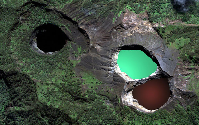 |
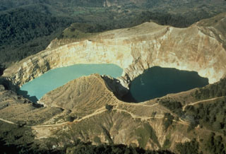
Figure 4. Kelimutu has three summit crater lakes seen in this photo. The lake Tiwi Ata Mbupu (left) is commonly blue. Tiwu Nua Muri Kooh Tai and Tiwu Ata Polo, which share a common crater wall, are typically green and red-colored, respectively. Photo courtesy of https://www.tripping.com. Posted 1 June 2013. |
During 13 - 18 June 2013, local tectonic quakes peaked at 139 before undergoing a decrease as of 17 June 2013. Shallow (VB) and deep (VA) volcanic earthquakes occurred intensely each day, reaching a a peak of 13 shallow volcanic quakes 19-24 June 2013 and then tended to decline (figure 5). Deep volcanic quakes peaked at 14 during 1-6 July 2013 and then subsided.
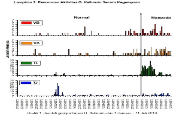 |
Figure 5. A plot of seismicity at Kelimutu during 1 June 2013 through 11 July 2013. Courtesy of CVGHM. |
No thermal alerts were recorded by MODVOLC for the past twelve months beginning in mid-July 2012.
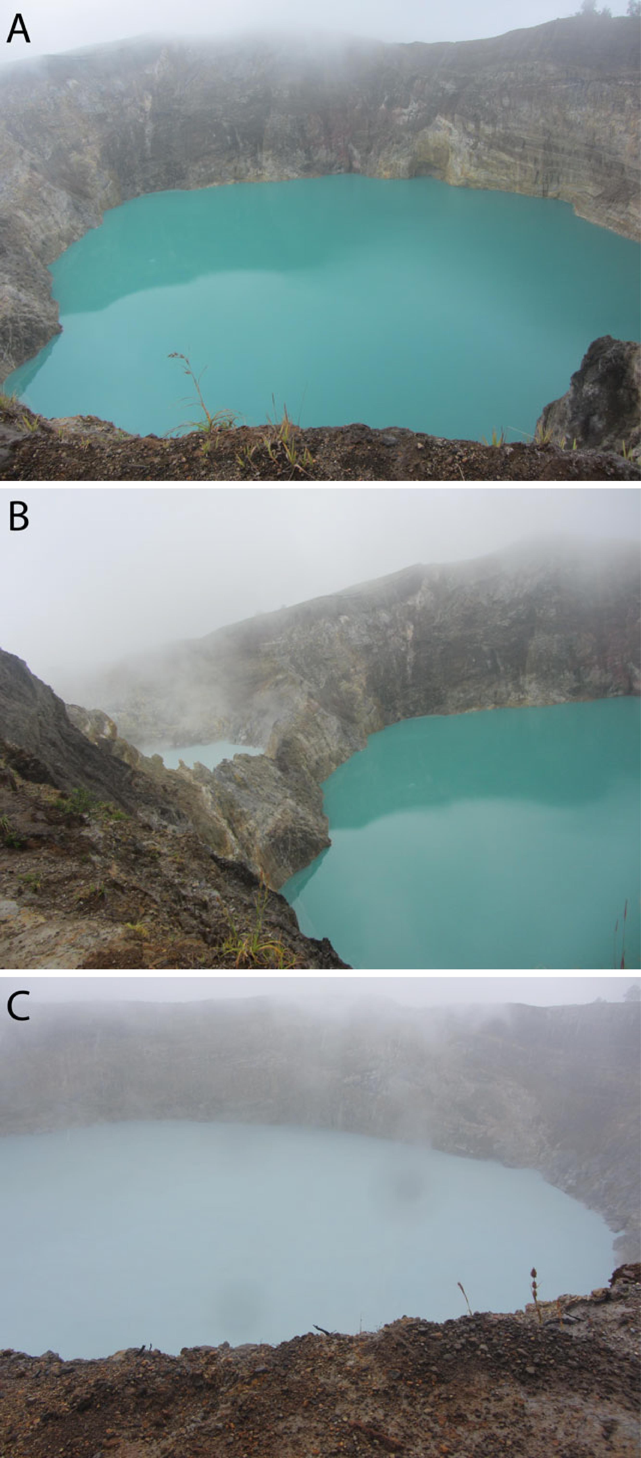 |
Figure 6. First photo (A) is Tiwu Ata Polo Lake (water color change from red to green), second photo (B) is between Tiwu Ata Polo Lake and Tiwu Nua Muri Kooh Fai Lake, and third photo (C) is Tiwu Nua Muri Kooh Fai Lake (water color change from green to white). Pictures taken on 6 June 2013 by Kristianto. |
Information Contacts: Center of Volcanology and Geological Hazard Mitigation (CVGHM), Jalan Diponegoro 57, Bandung 40122, Indonesia (URL: http://www.vsi.esdm.go.id/); and Hawai'i Institute of Geophysics and Planetology (HIGP) MODVOLC Thermal System, School of Ocean and Earth Science and Technology (SOEST), Univ. of Hawai'i, 2525 Correa Road, Honolulu, HI 96822 USA (URL: http;//hotspot.higp.hawaii.edu/).
2025: August
| November
2024: May
| July
| September
2013: June
| July
The Pusat Vulkanologi dan Mitigasi Bencana Geologi (PVMBG) reported another significant increase in the lake water temperature at Kelimutu’s Crater II (Tiwu Koofai Nuwamuri). The water temperature rose from 30.9 degrees Celsius (C) on 23 October, to 31.5 degrees C on 7 November, and then to 32.6 degrees C on 15 November. A minor sulfur odor accompanied the temperature increase along with the appearance of gas-and-steam on the lake’s surface. The color of the lake water had not changed, remaining light blue. There was no significant change in seismicity. The Alert Level remained at 1 (on a scale of 1-4) and the public was advised to not approach the crater rim and to wear a mask due to the sulfur odor.
Source: Pusat Vulkanologi dan Mitigasi Bencana Geologi (PVMBG, also known as CVGHM)
Pusat Vulkanologi dan Mitigasi Bencana Geologi (PVMBG) reported another significant increase in the lake water temperature at Kelimutu’s Crater II (Tiwu Koofai Nuwamuri). The temperature of the lake water rose from 34.2 degrees Celsius (C) on 26 August to 36.4 degrees C on 29 August. A strong sulfur odor accompanied the temperature increase along with the appearance of gas-and-steam on the lake’s surface. The color of the lake water had not changed, remaining light blue. There was no significant change in seismicity. The Alert Level remained at 1 (on a scale of 1-4) and the public was advised to limit activities near the craters, not approach the lake water, and to not spend the night in the craters.
Source: Pusat Vulkanologi dan Mitigasi Bencana Geologi (PVMBG, also known as CVGHM)
Pusat Vulkanologi dan Mitigasi Bencana Geologi (PVMBG) reported a significant increase in the lake water temperature at Kelimutu’s Crater II (Tiwu Koofai Nuwamuri). The temperature of the lake water rose from 25.3 degrees Celsius (C) on 18 August to 34.2 degrees C on 26 August. A very strong sulfur odor accompanied the temperature increase along with the appearance of gas-and-steam on the lake’s surface. The color of the lake water had not changed, remaining light blue. There was no significant change in seismicity. The Alert Level remained at 1 (on a scale of 1-4) and the public was advised to limit activities near the craters, not approach the lake water, and to not spend the night in the craters.
Source: Pusat Vulkanologi dan Mitigasi Bencana Geologi (PVMBG, also known as CVGHM)
Pusat Vulkanologi dan Mitigasi Bencana Geologi (PVMBG) reported that monitoring data and comparisons of recent field observations at Kelimutu indicated decreasing activity. Bubbling along the NE coast of the lake in Crater I (Tiwu Ata Polo) was observed on both 15 and 21 September. The temperature of the lake water was 22 and 24 degrees Celsius on 15 and 21 September, respectively. The lake water changed from dark green to bluish green. Conditions at Crater II (Tiwu Koofai Nuwamuri) were stable during 15-21 September, characterized by light blue crater water with small sulfur deposits floating in the middle of the lake and along the edges, diffuse white emissions rising 5 m above the lake’s surface, and a water temperature of 30 degrees Celsius. The color of the lake water at Crater III (Tiwu Ata Bupu) remained dark green on 15 and 21 September, the lake water was calm, and the temperature was 21 and 22 degrees Celsius, respectively. Seismicity was lower in September compared to August. The Alert Level was lowered to 1 (on a scale of 1-4) at 1600 on 23 September and the public was advised to limit activities near the craters, not approach the lake water, and to not spend the night in the craters.
Source: Pusat Vulkanologi dan Mitigasi Bencana Geologi (PVMBG, also known as CVGHM)
PVMBG reported temperature increases at all three of Kelimutu’s crater lakes and water-color changes at two of them based on 14 and 28 July field observations and webcam images. The variations were most significant at Crater I (Tiwu Ata Polo). The color of the water changed from brown on 14 July to blackish brown on 28 July and the temperature increased from 19 to 22 degrees Celsius. Water bubbles and/or upwelling in the NE part of the lake were observed on both days. At Crater II (Tiwu Koofai Nuwamuri) the water color was turquois green on 14 July. Light-yellow to golden-yellow sulfur deposits were floating on the water in the central part on the lake and along the S edge of the water on 14 July. There was a minor sulfur odor and the water temperature was 25 degrees Celsius. By 28 July the water color had changed to light blue and light-yellow sulfur deposits were scattered on the surface in the central part of the lake and along the margins. A sulfur odor was present and gas plumes rose as high as 100 m above the water’s surface. The water temperature had increased to 33 degrees Celsius. The color of the lake water at Crater III (Tiwu Ata Bupu) remained at dark green during 14-28 July, but the temperature increased from 16 to 19 degrees Celsius. Though the activity indicated increased activity within the hydrothermal system, the Alert Level remained at 2 (on a scale of 1-4) and the public was warned to stay 250 m from the crater rims.
Source: Pusat Vulkanologi dan Mitigasi Bencana Geologi (PVMBG, also known as CVGHM)
PVMBG reported that on 17 May the color of the crater lake water in Kelimutu’s Crater I (Tiwu Ata Polo) changed from green to dark green, water bubbles on the surface of the NE part of the lake were observed, and there was a weak sulfur odor. On 22 May the water color changed to a blackish-brown. The lake temperature dropped from 23 to 21 degrees Celsius during 17-22 May. At Crater II (Tiwu Koofai Nuwamuri) the water color was light blue on 17 May and had not changed color since the last visual observation. Golden-yellow sulfur deposits were scattered around the lake including in the central part and in areas to the NW, N, NE, E, and SE. Visual observations on 23 May revealed that the lake’s color had not changed, though sulfur deposits had shifted positions and had become more numerous. There was a swirling area of sulfur deposits on the water’s surface at the S part of the lake and a weak sulfur odor was noted. The lake temperature increased from 22 to 24 degrees Celsius during 17-23 May, indicating increased activity of the magmatic-hydrothermal system beneath it. The color of the lake water in Crater III (Tiwu Ata Bupu) was unchanged during 17-23 May. The changes in lake water color at Crater I, along with the changes in the floating sulfur deposits and increased water temperatures at Crater II, prompted PVMBG to raise the Alert Level to 2 (on a scale of 1-4) at 1300 on 24 May, and the public was warned to stay 250 m from the crater rims. According to a news article the Taman Nasional Kelimutu (Kelimutu National Park) restricted visitors from approaching the craters in accordance with the PVMBG guidelines. The last eruption was phreatic, and it occurred at Crater II during June 1968.
Sources: Pusat Vulkanologi dan Mitigasi Bencana Geologi (PVMBG, also known as CVGHM); Antara News
CVGHM reported that on 6, 10, and 12 June, and during 14 June-9 July, the color of the water in Kelimutu’s Crater II (Tiwu Nua Muri Kooh Tai Crater) was bluish white. Diffuse white plumes rose as high as 50 m above the lake’s surface and in some areas the water appeared or sounded like it was boiling. A sulfur odor was also reported. The water in Crater I (Tiwu Ata Polo) was light green and churned, and the water in Crater III (Tiwu Ata Mbupu) was mossy green.
During 22-29 June sulfur dioxide concentrations from Crater II were occasionally detected at 2.8 ppm, when the wind blew the gas towards the sensor. CVGHM noted that plumes rising from the lakes became lower and barely visible during 3 June-9 July, and that the “rustling sound” of water from near the dividing wall of craters I and II gradually faded away. Based on visual observations, seismicity, and gas emissions, CVGHM lowered the Alert Level to 1 (on a scale of 1-4) on 12 July.
Source: Pusat Vulkanologi dan Mitigasi Bencana Geologi (PVMBG, also known as CVGHM)
CVGHM reported that on 3 June the water in Kelimutu’s Crater II (Tiwu Nua Muri Kooh Tai Crater) turned from blue to a light brown color, “smoke” rose 50 m above the crater, “rustling water sounds” were heard near the wall of Crater I (Tiwu Ata Polo), and a sharp sulfur odor was noted. That evening a weak sulfur odor was reported in Pemo (3 km). Plants within 2 km S and SE appeared to have wilted.
Based on seismicity from 20 May-2 June and visual observations on 3 June, CVGHM raised the Alert Level to 2 (on a scale of 1-4), and warned the public not to approach the craters within a radius of 2 km and to avoid river valleys.
Source: Pusat Vulkanologi dan Mitigasi Bencana Geologi (PVMBG, also known as CVGHM)
Reports are organized chronologically and indexed below by Month/Year (Publication Volume:Number), and include a one-line summary. Click on the index link or scroll down to read the reports.
Gas emission from crater lake; felt earthquake
". . . signs of unrest from the Tiwu Nua Muri crater . . . consisted of increased gas bubbling from the crater lake beginning on 27 April and a felt earthquake on 28 April."
Information Contacts: Olas, Suratman, Suparto, Kaswanda, and A. Sudradjat, VSI.
Degassing from one of three crater lakes and flank fumaroles
In November, moderate degassing with a weak sulfur odor occurred from the the E crater's Tiwu Ata Polo, reddish in 1986 and dark green in 1989. No degassing was evident from the light green Tiwu Nua Muri Kooh Tai in the central crater. A small amount of sulfur was deposited around the lakeshore. In the W crater, Tiwu Ata Mbupu, dark brown in May, was greenish in November. No degassing or other activity was evident. Fumaroles on the upper flanks had temperatures of [96-97°C] in 21°C air. An earthquake was felt at MM II on 28 June at 2255. November seismicity included [three] A-type and [two] B-type events, plus [23] local and [37] distant tectonic earthquakes.
Information Contacts: VSI.
Increased seismicity for three months
[Seismicity rose during February-April 1993, with 318 deep and 196 shallow earthquakes, but declined in June (VSI, 1993a).] (originally in 20:06)
Reference. Volcanological Survey of Indonesia, 1993a, Kelimutu Volcano: Journal of Volcanic Activity in Indonesia, v. 1:1/2, p. 14.
Information Contacts: VSI.
Minor bubbling in very acidic crater lake
Between 15 and 19 May 1995 a search was conducted for the body of a missing Dutch tourist who had fallen into one of Kelimutu's three crater lakes (figures 1, 2, and 3). During the search of the turquoise-blue Tiwu Nua Muri Kooh Tai lake, ~600 x 380 m in size and located 100-150 m below the crater rim, pH measured by litmus-paper was 0.5. Access to the crater lake was achieved by rope-aided descent, but rocks on the crater wall were very loose and rockfalls were frequent. A portable boat was used to tow a dredging net to comb the 3-6 m depth range of the entire lake. The water temperature was 37°C, ~8° cooler than the air. A film of yellow sulfur (~30 x 150 m) floated on the lake's surface. The searchers breathed bottled oxygen because of the high levels of SO2 in the air, which measured 5 ppm. On 18 May "little bubbles or very small fountains" were observed within the lake. Although the body was not recovered, the search was terminated on 19 May.
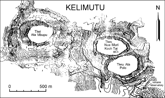 |
Figure 1. Map of the summit area of Kelimutu showing the three crater lakes and the location of the volcano observatory. |
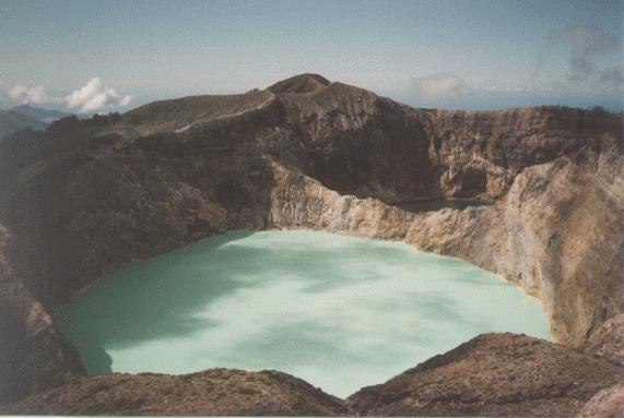 |
Figure 2. Kelimutu summit area in mid-May 1995, view is to the SE. The turquoise-green Tiwu Nua Muri Kooh Tai crater lake is in the foreground (~600 x 380 m) with the darker-colored Tiwu Ata Polo crater lake behind it to the right. Photograph courtesy of Ton Biesemat, Outdoor Magazine. |
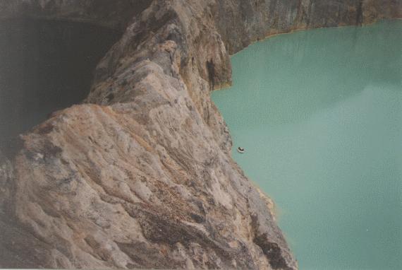 |
Figure 3. Crater lakes at Kelimutu, mid-May 1995. View is approximately WSW looking along the heavily altered shared crater rim between the turquoise-green Tiwu Nua Muri Kooh lake (right) and the dark Tiwu Ata Polo lake (left). Photograph courtesy of Ton Biesemat, Outdoor Magazine. |
Further Reference. Outdoor Magazine, Bergingsactie op een actieve vulkaan, De Kelimutu Zwijgt, 3e jaargang:4, July 1995, p. 40-45 (in Dutch, with 14 photos).
Information Contacts: Ton Biesemaat, Outdoor Magazine, Netherlands; VSI; AP; UPI.
Crater water boils; diffuse, white plume increases to 50 m
This volcano is well known for three summit crater lakes, each a different color. We last reported minor bubbling in a crater lake Tiwu Nua Muri Kooh Tai lake in 1995 (BGVN 20:06). Between 15 and 19 May 1995, rescuers searched for the body of a Dutch tourist who had fallen into the crater lake but they did not find it.
2013 activity.The Center of Volcanology and Geological Hazard Mitigation (CVGHM) reported that on 6, 10, and 12 June 2013, and during 14 June-9 July 2013, the color of the water in Kelimutu's Crater II (Tiwu Nua Muri Kooh Tai Crater) was bluish white. Diffuse white plumes rose as high as 50 m above the lake's surface and in some areas the water appeared or sounded like it was boiling. A sulfur odor was also reported. The water in Crater I (Tiwu Ata Polo) was light green and churned, and the water in Crater III (Tiwu Ata Mbupu) was mossy green.
On 3 June 2013, a change was observed in the color of the lake water in Crater II, going from blue to a café au lait (light tan), accompanied by white smoke under weak to medium pressure, rising 50 meters above the surface of the lake. From the southern side of Crater II a bubbling sound of boiling was heard near the wall separating Crater I from Crater II. The smell of sulphur gas was quite sharp in the vicinity of the crater and at nighttime a weak to medium smell of this gas could be discerned in Pemo Village which is 3 kms from the peak of Kelimutu. On 4 June 2013 at 1400 hours local time the status of Kelimutu was upgraded from Alert Level 1 (Normal) to Alert Level 2 (Waspada).
On 6 June 2013 water in Crater II was a bluish white (like a salty egg), with sparse to medium white smoke under weak to strong pressure extending up 10-35 meters above the lake surface. A weak to strong bubbling sound of boiling water was heard on the southern side of the crater. A medium to sharp smell of sulphurous gas was evident as was the withering vegetation.
On 10 June 2013 water in Crater II was still a bluish white with medium to dense white smoke extending up 40-50 m above the lake surface. A bubbling sound of boiling water could be heard on the southern side of the crater. A medium smell of sulphurous gases was discernible.
On 12 June 2013, smoke rising from the surface of the lake extended to only about 10-30 meters above the lip of the crater. There was a rather acrid smell of sulphurous fumes. Eruptive and hot air noises were audible two times and the water in the crater lake still appeared to be boiling.
From 14 June to 9 July 2013, water in Crater II visually still appeared bluish white with sparse white smoke rising from the surface of the lake about 2-10 meters into the atmosphere (dominant height was not observed). There was a weak to medium (with weak dominating) smell of sulphurous gases. At one point bubbling water was noticeable but it was clearly under weak pressure. Water from Crater III was calm and moss-green in color.
During 22-29 June 2013 sulfur dioxide concentrations in Crater II were occasionally 2.8 ppm, when the wind blew the gas towards the sensor. CVGHM noted that plumes rising from the lakes became lower and barely visible during 3 June-9 July, and that the hissing or "rustling sound" of water from near the dividing wall of craters I and II had gradually faded away. Based on visual observations, seismicity, and gas emissions, CVGHM lowered the Alert Level to 1 (on a scale of 1-4) on 12 July (figure 4).
|
Figure 4. Kelimutu has three summit crater lakes seen in this photo. The lake Tiwi Ata Mbupu (left) is commonly blue. Tiwu Nua Muri Kooh Tai and Tiwu Ata Polo, which share a common crater wall, are typically green and red-colored, respectively. Photo courtesy of https://www.tripping.com. Posted 1 June 2013. |
During 13 - 18 June 2013, local tectonic quakes peaked at 139 before undergoing a decrease as of 17 June 2013. Shallow (VB) and deep (VA) volcanic earthquakes occurred intensely each day, reaching a a peak of 13 shallow volcanic quakes 19-24 June 2013 and then tended to decline (figure 5). Deep volcanic quakes peaked at 14 during 1-6 July 2013 and then subsided.
|
Figure 5. A plot of seismicity at Kelimutu during 1 June 2013 through 11 July 2013. Courtesy of CVGHM. |
No thermal alerts were recorded by MODVOLC for the past twelve months beginning in mid-July 2012.
|
Figure 6. First photo (A) is Tiwu Ata Polo Lake (water color change from red to green), second photo (B) is between Tiwu Ata Polo Lake and Tiwu Nua Muri Kooh Fai Lake, and third photo (C) is Tiwu Nua Muri Kooh Fai Lake (water color change from green to white). Pictures taken on 6 June 2013 by Kristianto. |
Information Contacts: Center of Volcanology and Geological Hazard Mitigation (CVGHM), Jalan Diponegoro 57, Bandung 40122, Indonesia (URL: http://www.vsi.esdm.go.id/); and Hawai'i Institute of Geophysics and Planetology (HIGP) MODVOLC Thermal System, School of Ocean and Earth Science and Technology (SOEST), Univ. of Hawai'i, 2525 Correa Road, Honolulu, HI 96822 USA (URL: http;//hotspot.higp.hawaii.edu/).
|
|
||||||||||||||||||||||||||
There is data available for 3 confirmed eruptive periods.
1968 Jun 3 - 1968 Jul 29 Confirmed Eruption (Explosive / Effusive) VEI: 1
| Episode 1 | Eruption (Explosive / Effusive) | Tiwu Nua Muri | ||||||||||||||||||||||||||||
|---|---|---|---|---|---|---|---|---|---|---|---|---|---|---|---|---|---|---|---|---|---|---|---|---|---|---|---|---|---|
| 1968 Jun 3 - 1968 Jul 29 | Evidence from Observations: Reported | ||||||||||||||||||||||||||||
|
List of 4 Events for Episode 1 at Tiwu Nua Muri
|
|||||||||||||||||||||||||||||
1938 May - 1938 Jun Confirmed Eruption (Explosive / Effusive) VEI: 2
| Episode 1 | Eruption (Explosive / Effusive) | |||||||||||||||||||
|---|---|---|---|---|---|---|---|---|---|---|---|---|---|---|---|---|---|---|---|
| 1938 May - 1938 Jun | Evidence from Observations: Reported | ||||||||||||||||||
|
List of 2 Events for Episode 1
|
|||||||||||||||||||
1865 ± 5 years Confirmed Eruption (Explosive / Effusive) VEI: 2
| Episode 1 | Eruption (Explosive / Effusive) | |||||||||||||||||||
|---|---|---|---|---|---|---|---|---|---|---|---|---|---|---|---|---|---|---|---|
| 1865 ± 5 years - Unknown | Evidence from Observations: Reported | ||||||||||||||||||
|
List of 2 Events for Episode 1
|
|||||||||||||||||||
This compilation of synonyms and subsidiary features may not be comprehensive. Features are organized into four major categories: Cones, Craters, Domes, and Thermal Features. Synonyms of features appear indented below the primary name. In some cases additional feature type, elevation, or location details are provided.
Synonyms |
||||
| Geli Mutu | Gli Moetoe | Mutu | Geli Moetoe | ||||
Cones |
||||
| Feature Name | Feature Type | Elevation | Latitude | Longitude |
| Kelibara | Cone | 1630 m | ||
| Kelido | Cone | 1442 m | ||
Craters |
||||
| Feature Name | Feature Type | Elevation | Latitude | Longitude |
| Tiwu Ata Mbupu | Crater | 1640 m | ||
| Tiwu Ata Polo | Crater | 1570 m | ||
| Tiwu Nua Muri Kooh Tai
Tiwu Nua Muri Koohi Fah |
Crater | 1548 m | ||
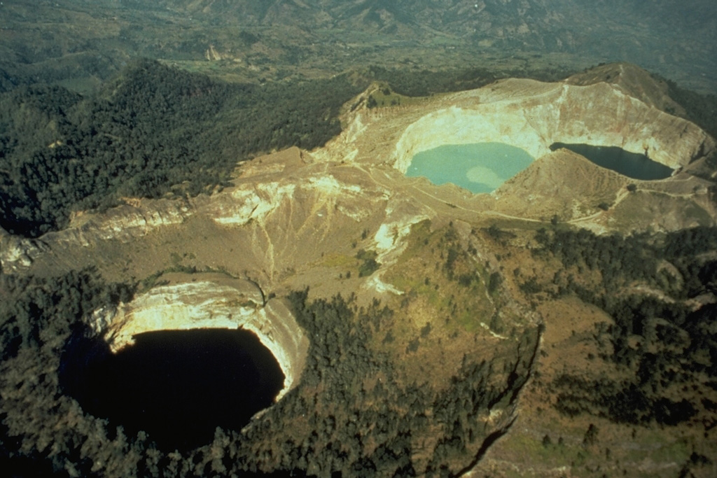
 The two crater lakes of Kelimutu volcano on Indonesia's Flores Island are seen in this aerial view from the SW. Tiwu Nua Muri Kooh Tai (Lake of Young Men and Maidens) on the left and Tiwu Ata Polo (Bewitched or Enchanted Lake) are separated by a narrow crater wall about 35 m high. Phreatic eruptions have occurred from Tiwu Nua Muri Kooh Tai in the 19th and 20th centuries.
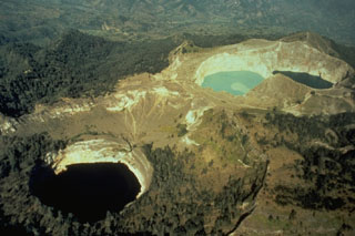 Kelimutu, a small volcano on Flores Island, is noted for its three crater lakes of different colors. This aerial view from the SW shows Tiwu Ata Mbupu at the lower left, and the two craters of Tiwu Nua Muri Kooh Taiand Tiwu and Ata Polo at the upper right. Water color varies periodically with variations of blue, green, and red. Phreatic eruptions have occurred from the middle lake in historical time.
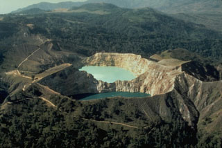 The SE-most pair of Kelimutu's crater lakes, Tiwu Ata Polo and Tiwu Nua Muri Kooh Tai, are seen here in an aerial view from the SE. A light-colored area of upwelling can be seen in the upper lake and this also occurs in the lower one. All three lakes are close to saturation with gypsum/anhydrite, contributing to color variations.
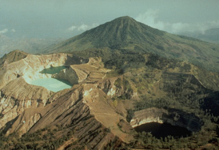 The summit of Kelimutu volcano is elongated 2 km in a NNW-ESE direction, and contains three crater lakes of different colors that are one of the most popular tourist destinations on Flores Island. This view from the north shows the three crater lakes with Keli Bara cone in the background. Phreatic explosions have occurred from the middle lake in historical time.
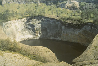 Tiwu Ata Mbupu is the NW-most of three craters on Kelimutu. It is 850 x 600 m wide and contains a 67-m-deep crater lake. The shoreline of the lake is coated with red/yellow minerals and gypsum crystals. Lake color tends to vary seasonally.
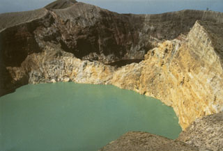 The walls of Tiwu Nua Muri Kooh Tai, the middle of Kelimutu's three crater lakes, expose bedded hydrothermally altered rocks. Tiwu Ata Polo, the darker-colored crater lake to the SE, is visible beyond the far wall. Constant upwelling occurs at these two lakes, probably as a result of subaqueous fumaroles, directing floating sulfur in Tiwu Nua Muri Kooh Tai toward the crater walls.
 The summit of Kelimutu volcano is elongated 2-3 km in a WNW-ESE direction and contains three crater lakes. A trail ascending the eastern wall of the NW-most cone leads to Tiwu Ata Mbupu crater lake.
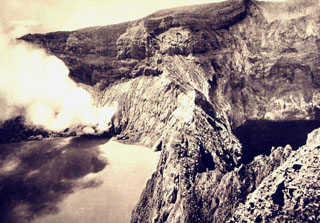 A plume rises from a fumarole on the crater wall of light-colored Tiwu Nua Muri Kooh Tai lake. A sharp ridge separates the crater lake from the dark-colored Tiwu Alta Polo lake (right), the easternmost of the two craters.
 There are no samples for Kelimutu in the Smithsonian's NMNH Department of Mineral Sciences Rock and Ore collection.
| Copernicus Browser | The Copernicus Browser replaced the Sentinel Hub Playground browser in 2023, to provide access to Earth observation archives from the Copernicus Data Space Ecosystem, the main distribution platform for data from the EU Copernicus missions. |
| MIROVA | Middle InfraRed Observation of Volcanic Activity (MIROVA) is a near real time volcanic hot-spot detection system based on the analysis of MODIS (Moderate Resolution Imaging Spectroradiometer) data. In particular, MIROVA uses the Middle InfraRed Radiation (MIR), measured over target volcanoes, in order to detect, locate and measure the heat radiation sourced from volcanic activity. |
| MODVOLC Thermal Alerts | Using infrared satellite Moderate Resolution Imaging Spectroradiometer (MODIS) data, scientists at the Hawai'i Institute of Geophysics and Planetology, University of Hawai'i, developed an automated system called MODVOLC to map thermal hot-spots in near real time. For each MODIS image, the algorithm automatically scans each 1 km pixel within it to check for high-temperature hot-spots. When one is found the date, time, location, and intensity are recorded. MODIS looks at every square km of the Earth every 48 hours, once during the day and once during the night, and the presence of two MODIS sensors in space allows at least four hot-spot observations every two days. Each day updated global maps are compiled to display the locations of all hot spots detected in the previous 24 hours. There is a drop-down list with volcano names which allow users to 'zoom-in' and examine the distribution of hot-spots at a variety of spatial scales. |
|
WOVOdat
Single Volcano View Temporal Evolution of Unrest Side by Side Volcanoes |
WOVOdat is a database of volcanic unrest; instrumentally and visually recorded changes in seismicity, ground deformation, gas emission, and other parameters from their normal baselines. It is sponsored by the World Organization of Volcano Observatories (WOVO) and presently hosted at the Earth Observatory of Singapore.
GVMID Data on Volcano Monitoring Infrastructure The Global Volcano Monitoring Infrastructure Database GVMID, is aimed at documenting and improving capabilities of volcano monitoring from the ground and space. GVMID should provide a snapshot and baseline view of the techniques and instrumentation that are in place at various volcanoes, which can be use by volcano observatories as reference to setup new monitoring system or improving networks at a specific volcano. These data will allow identification of what monitoring gaps exist, which can be then targeted by remote sensing infrastructure and future instrument deployments. |
| Volcanic Hazard Maps | The IAVCEI Commission on Volcanic Hazards and Risk has a Volcanic Hazard Maps database designed to serve as a resource for hazard mappers (or other interested parties) to explore how common issues in hazard map development have been addressed at different volcanoes, in different countries, for different hazards, and for different intended audiences. In addition to the comprehensive, searchable Volcanic Hazard Maps Database, this website contains information about diversity of volcanic hazard maps, illustrated using examples from the database. This site is for educational purposes related to volcanic hazard maps. Hazard maps found on this website should not be used for emergency purposes. For the most recent, official hazard map for a particular volcano, please seek out the proper institutional authorities on the matter. |
| IRIS seismic stations/networks | Incorporated Research Institutions for Seismology (IRIS) Data Services map showing the location of seismic stations from all available networks (permanent or temporary) within a radius of 0.18° (about 20 km at mid-latitudes) from the given location of Kelimutu. Users can customize a variety of filters and options in the left panel. Note that if there are no stations are known the map will default to show the entire world with a "No data matched request" error notice. |
| UNAVCO GPS/GNSS stations | Geodetic Data Services map from UNAVCO showing the location of GPS/GNSS stations from all available networks (permanent or temporary) within a radius of 20 km from the given location of Kelimutu. Users can customize the data search based on station or network names, location, and time window. Requires Adobe Flash Player. |
| DECADE Data | The DECADE portal, still in the developmental stage, serves as an example of the proposed interoperability between The Smithsonian Institution's Global Volcanism Program, the Mapping Gas Emissions (MaGa) Database, and the EarthChem Geochemical Portal. The Deep Earth Carbon Degassing (DECADE) initiative seeks to use new and established technologies to determine accurate global fluxes of volcanic CO2 to the atmosphere, but installing CO2 monitoring networks on 20 of the world's 150 most actively degassing volcanoes. The group uses related laboratory-based studies (direct gas sampling and analysis, melt inclusions) to provide new data for direct degassing of deep earth carbon to the atmosphere. |
| Large Eruptions of Kelimutu | Information about large Quaternary eruptions (VEI >= 4) is cataloged in the Large Magnitude Explosive Volcanic Eruptions (LaMEVE) database of the Volcano Global Risk Identification and Analysis Project (VOGRIPA). |
| EarthChem | EarthChem develops and maintains databases, software, and services that support the preservation, discovery, access and analysis of geochemical data, and facilitate their integration with the broad array of other available earth science parameters. EarthChem is operated by a joint team of disciplinary scientists, data scientists, data managers and information technology developers who are part of the NSF-funded data facility Integrated Earth Data Applications (IEDA). IEDA is a collaborative effort of EarthChem and the Marine Geoscience Data System (MGDS). |

