Based on analyses of satellite imagery, the Darwin VAAC reported that on 23 April a possible ash plume from Tongkoko rose to an altitude of 10.7 km (35,000 ft) a.s.l. [Note: The Darwin VAAC later stated that, according to CVGHM, the plume was caused by a fire and not an eruption.]
Source: Darwin Volcanic Ash Advisory Centre (VAAC)
Volcanic earthquakes during October 2002-January 2003
The Volcanological Survey of Indonesia (VSI) reported deep volcanic and A-type earthquakes at Tongkoko (also known as Tangkoko) over the period 7 October-24 November 2002 and more deep-volcanic events during 23 December 2002-19 January 2003 (table 1). The earthquakes, which began in May 2002, were recorded following relocation of an observatory post to Wainenet village in the Bitung area. The temperature at Batu Angus hot spring on 10 October 2002 was 70-73°C. While no visible activity has been observed, the hazard status was raised to Alert Level 2 (on a scale of 1-4) on 24 October 2002 as a result of the increased seismicity. The last recorded activity at Tongkoko consisted of flank lava flows and lava dome extrusion in 1880.
Table 1. Earthquakes recorded at Tongkoko, 7 October 2002-19 January 2003. In addition, one shallow volcanic event was recorded during 13-19 January 2003, and single B-type earthquakes each occurred during 21-27 October and 4-10 November 2002. Courtesy of VSI.
| Date | Deep Volcanic (B-type) | Shallow volcanic (A-type) | Tectonic |
| 07 Oct-13 Oct 2002 | 4 | -- | -- |
| 14 Oct-20 Oct 2002 | -- | 12 | 23 |
| 21 Oct-27 Oct 2002 | -- | 9 | 34 |
| 28 Oct-03 Nov 2002 | -- | 17 | 19 |
| 04 Nov-10 Nov 2002 | -- | 9 | 38 |
| 11 Nov-18 Nov 2002 | -- | 2 | 37 |
| 19 Nov-24 Nov 2002 | -- | 2 | 25 |
| 23 Dec-29 Dec 2002 | 5 | -- | 16 |
| 06 Jan-12 Jan 2003 | 11 | -- | 21 |
| 13 Jan-19 Jan 2003 | 5 | -- | 28 |
Information Contacts: Dali Ahmad, Hetty Triastuty, Nia Haerani, and Suswati, Volcanological Survey of Indonesia (VSI), Jalan Diponegoro No. 57, Bandung 40122, Indonesia (URL: http://www.vsi.esdm.go.id/).
Based on analyses of satellite imagery, the Darwin VAAC reported that on 23 April a possible ash plume from Tongkoko rose to an altitude of 10.7 km (35,000 ft) a.s.l. [Note: The Darwin VAAC later stated that, according to CVGHM, the plume was caused by a fire and not an eruption.]
Source: Darwin Volcanic Ash Advisory Centre (VAAC)
An increase in the number of volcanic earthquakes at Tongkoko since 24 October led VSI to raise the Alert Level from 1 to 2. The number of deep volcanic earthquakes decreased in comparison to the previous week. VSI reported that the increased number of shallow volcanic earthquakes indicated that seismicity was migrating to the surface.
Source: Pusat Vulkanologi dan Mitigasi Bencana Geologi (PVMBG, also known as CVGHM)
Relocation of an observatory to the area near Tongkoko provided scientists with previously unavailable seismic data. During 7-14 October, four deep-volcanic events were recorded at Tongkoko. This is significant because the volcano has been in repose for almost 122 years. Tongkoko was at Alert Level 1 (on a scale of 1-4) (note: VSI later corrected Alert Level from 2).
Source: Pusat Vulkanologi dan Mitigasi Bencana Geologi (PVMBG, also known as CVGHM)
Reports are organized chronologically and indexed below by Month/Year (Publication Volume:Number), and include a one-line summary. Click on the index link or scroll down to read the reports.
Volcanic earthquakes during October 2002-January 2003
The Volcanological Survey of Indonesia (VSI) reported deep volcanic and A-type earthquakes at Tongkoko (also known as Tangkoko) over the period 7 October-24 November 2002 and more deep-volcanic events during 23 December 2002-19 January 2003 (table 1). The earthquakes, which began in May 2002, were recorded following relocation of an observatory post to Wainenet village in the Bitung area. The temperature at Batu Angus hot spring on 10 October 2002 was 70-73°C. While no visible activity has been observed, the hazard status was raised to Alert Level 2 (on a scale of 1-4) on 24 October 2002 as a result of the increased seismicity. The last recorded activity at Tongkoko consisted of flank lava flows and lava dome extrusion in 1880.
Table 1. Earthquakes recorded at Tongkoko, 7 October 2002-19 January 2003. In addition, one shallow volcanic event was recorded during 13-19 January 2003, and single B-type earthquakes each occurred during 21-27 October and 4-10 November 2002. Courtesy of VSI.
| Date | Deep Volcanic (B-type) | Shallow volcanic (A-type) | Tectonic |
| 07 Oct-13 Oct 2002 | 4 | -- | -- |
| 14 Oct-20 Oct 2002 | -- | 12 | 23 |
| 21 Oct-27 Oct 2002 | -- | 9 | 34 |
| 28 Oct-03 Nov 2002 | -- | 17 | 19 |
| 04 Nov-10 Nov 2002 | -- | 9 | 38 |
| 11 Nov-18 Nov 2002 | -- | 2 | 37 |
| 19 Nov-24 Nov 2002 | -- | 2 | 25 |
| 23 Dec-29 Dec 2002 | 5 | -- | 16 |
| 06 Jan-12 Jan 2003 | 11 | -- | 21 |
| 13 Jan-19 Jan 2003 | 5 | -- | 28 |
Information Contacts: Dali Ahmad, Hetty Triastuty, Nia Haerani, and Suswati, Volcanological Survey of Indonesia (VSI), Jalan Diponegoro No. 57, Bandung 40122, Indonesia (URL: http://www.vsi.esdm.go.id/).
|
|
||||||||||||||||||||||||||
There is data available for 7 confirmed Holocene eruptive periods.
1880 Confirmed Eruption (Explosive / Effusive) VEI: 1
| Episode 1 | Eruption (Explosive / Effusive) | Batu Angus | ||||||||||||||||||||||||
|---|---|---|---|---|---|---|---|---|---|---|---|---|---|---|---|---|---|---|---|---|---|---|---|---|---|
| 1880 - Unknown | Evidence from Observations: Reported | ||||||||||||||||||||||||
|
List of 3 Events for Episode 1 at Batu Angus
|
|||||||||||||||||||||||||
1843 - 1846 Confirmed Eruption (Explosive / Effusive) VEI: 2
| Episode 1 | Eruption (Explosive / Effusive) | Batu Angus | |||||||||||||||||||
|---|---|---|---|---|---|---|---|---|---|---|---|---|---|---|---|---|---|---|---|---|
| 1843 - 1846 | Evidence from Observations: Reported | |||||||||||||||||||
|
List of 2 Events for Episode 1 at Batu Angus
|
||||||||||||||||||||
1821 Confirmed Eruption (Explosive / Effusive) VEI: 0
| Episode 1 | Eruption (Explosive / Effusive) | Batu Angus Baru | |||||||||||||||||||
|---|---|---|---|---|---|---|---|---|---|---|---|---|---|---|---|---|---|---|---|---|
| 1821 - Unknown | Evidence from Observations: Reported | |||||||||||||||||||
|
List of 2 Events for Episode 1 at Batu Angus Baru
|
||||||||||||||||||||
1801 Confirmed Eruption (Explosive / Effusive) VEI: 2
| Episode 1 | Eruption (Explosive / Effusive) | Summit and east flank (Batu Angus) | |||||||||||||||||||||||||||||||||||||||
|---|---|---|---|---|---|---|---|---|---|---|---|---|---|---|---|---|---|---|---|---|---|---|---|---|---|---|---|---|---|---|---|---|---|---|---|---|---|---|---|---|
| 1801 - Unknown | Evidence from Observations: Reported | |||||||||||||||||||||||||||||||||||||||
|
List of 6 Events for Episode 1 at Summit and east flank (Batu Angus)
|
||||||||||||||||||||||||||||||||||||||||
1694 Confirmed Eruption (Explosive / Effusive) VEI: 3 (?)
| Episode 1 | Eruption (Explosive / Effusive) | ||||||||||||||||||||
|---|---|---|---|---|---|---|---|---|---|---|---|---|---|---|---|---|---|---|---|---|
| 1694 - Unknown | Evidence from Observations: Reported | |||||||||||||||||||
|
List of 2 Events for Episode 1
|
||||||||||||||||||||
1683 Confirmed Eruption (Explosive / Effusive) VEI: 3
| Episode 1 | Eruption (Explosive / Effusive) | ||||||||||||||||||||
|---|---|---|---|---|---|---|---|---|---|---|---|---|---|---|---|---|---|---|---|---|
| 1683 - Unknown | Evidence from Observations: Reported | |||||||||||||||||||
|
List of 2 Events for Episode 1
|
||||||||||||||||||||
1680 Confirmed Eruption (Explosive / Effusive) VEI: 5 (?)
| Episode 1 | Eruption (Explosive / Effusive) | ||||||||||||||||||||||||||||||
|---|---|---|---|---|---|---|---|---|---|---|---|---|---|---|---|---|---|---|---|---|---|---|---|---|---|---|---|---|---|---|
| 1680 - Unknown | Evidence from Observations: Reported | |||||||||||||||||||||||||||||
|
List of 4 Events for Episode 1
|
||||||||||||||||||||||||||||||
This compilation of synonyms and subsidiary features may not be comprehensive. Features are organized into four major categories: Cones, Craters, Domes, and Thermal Features. Synonyms of features appear indented below the primary name. In some cases additional feature type, elevation, or location details are provided.
Cones |
||||
| Feature Name | Feature Type | Elevation | Latitude | Longitude |
| Duasudara
Dua Sudara Dua Saudara |
Stratovolcano | 1334 m | 1° 29' 8.00" N | 125° 9' 30.00" E |
| Tangkoko
Tonkoko Tokoko Tangkoko |
Stratovolcano | 1113 m | 1° 31' 5.00" N | 125° 11' 5.00" E |
Domes |
||||
| Feature Name | Feature Type | Elevation | Latitude | Longitude |
| Baru Batuangus
Baru Batu Angus |
Dome | 480 m | 1° 30' 20.00" N | 125° 12' 44.00" E |
| Batuangus
Angoes, Batoe Angus, Batu |
Dome | 404 m | 1° 30' 33.00" N | 125° 12' 11.00" E |
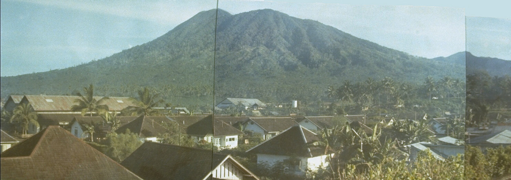
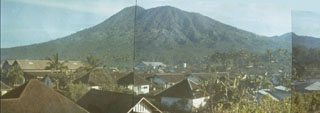 The 1149-m-high elongated Tongkoko volcano, seen in this composite photo from the south, rises above Bitung city and is the NE-most volcano on the island of Sulawesi. The summit of the volcano, which is elongated in a NW-SE direction, contains a large crater with a central cone. Historical eruptions have occurred since 1680 from both the summit and an east flank vent, Batu Angus. Tongkoko volcano and its neighbor Dua Saudara are the most prominent features of Gunung Dua Saudara National Park, a noted wildlife preserve.
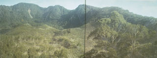 The forested summit of Tongkoko volcano at the NE tip of Sulawesi is truncated by a large elongated, 1 x 2 km wide crater that contains a central cone. In 1801 a crater lake was observed. Eruptions have occurred at Tongkoko during historical time from both summit and flank craters.
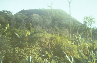 The flat-topped Batu Angus lava dome formed on the east flank of Tongkoko volcano during an eruption in 1801. A lava flow traveled 2 km down the flank. The 1801 eruption also included formation of small cones at the bottom of the crater lake at the summit of the volcano.
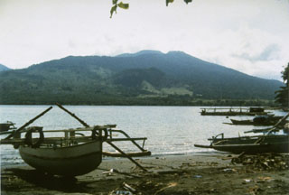 Tongkoko volcano, seen here from Lembe Island to the east, is a broad, 1149-m-high stratovolcano capped by a large summit crater. The lava dome Batu Angus, which formed in an eruption in 1801, can be seen on the east flank of the volcano in the center of the photo. Gunung Dua Saudara National Park, a noted wildlife preserve, extends from the volcanic highlands to offshore coral reefs.
 There are no samples for Tangkoko-Duasudara in the Smithsonian's NMNH Department of Mineral Sciences Rock and Ore collection.
| Copernicus Browser | The Copernicus Browser replaced the Sentinel Hub Playground browser in 2023, to provide access to Earth observation archives from the Copernicus Data Space Ecosystem, the main distribution platform for data from the EU Copernicus missions. |
| MIROVA | Middle InfraRed Observation of Volcanic Activity (MIROVA) is a near real time volcanic hot-spot detection system based on the analysis of MODIS (Moderate Resolution Imaging Spectroradiometer) data. In particular, MIROVA uses the Middle InfraRed Radiation (MIR), measured over target volcanoes, in order to detect, locate and measure the heat radiation sourced from volcanic activity. |
| MODVOLC Thermal Alerts | Using infrared satellite Moderate Resolution Imaging Spectroradiometer (MODIS) data, scientists at the Hawai'i Institute of Geophysics and Planetology, University of Hawai'i, developed an automated system called MODVOLC to map thermal hot-spots in near real time. For each MODIS image, the algorithm automatically scans each 1 km pixel within it to check for high-temperature hot-spots. When one is found the date, time, location, and intensity are recorded. MODIS looks at every square km of the Earth every 48 hours, once during the day and once during the night, and the presence of two MODIS sensors in space allows at least four hot-spot observations every two days. Each day updated global maps are compiled to display the locations of all hot spots detected in the previous 24 hours. There is a drop-down list with volcano names which allow users to 'zoom-in' and examine the distribution of hot-spots at a variety of spatial scales. |
|
WOVOdat
Single Volcano View Temporal Evolution of Unrest Side by Side Volcanoes |
WOVOdat is a database of volcanic unrest; instrumentally and visually recorded changes in seismicity, ground deformation, gas emission, and other parameters from their normal baselines. It is sponsored by the World Organization of Volcano Observatories (WOVO) and presently hosted at the Earth Observatory of Singapore.
GVMID Data on Volcano Monitoring Infrastructure The Global Volcano Monitoring Infrastructure Database GVMID, is aimed at documenting and improving capabilities of volcano monitoring from the ground and space. GVMID should provide a snapshot and baseline view of the techniques and instrumentation that are in place at various volcanoes, which can be use by volcano observatories as reference to setup new monitoring system or improving networks at a specific volcano. These data will allow identification of what monitoring gaps exist, which can be then targeted by remote sensing infrastructure and future instrument deployments. |
| Volcanic Hazard Maps | The IAVCEI Commission on Volcanic Hazards and Risk has a Volcanic Hazard Maps database designed to serve as a resource for hazard mappers (or other interested parties) to explore how common issues in hazard map development have been addressed at different volcanoes, in different countries, for different hazards, and for different intended audiences. In addition to the comprehensive, searchable Volcanic Hazard Maps Database, this website contains information about diversity of volcanic hazard maps, illustrated using examples from the database. This site is for educational purposes related to volcanic hazard maps. Hazard maps found on this website should not be used for emergency purposes. For the most recent, official hazard map for a particular volcano, please seek out the proper institutional authorities on the matter. |
| IRIS seismic stations/networks | Incorporated Research Institutions for Seismology (IRIS) Data Services map showing the location of seismic stations from all available networks (permanent or temporary) within a radius of 0.18° (about 20 km at mid-latitudes) from the given location of Tangkoko-Duasudara. Users can customize a variety of filters and options in the left panel. Note that if there are no stations are known the map will default to show the entire world with a "No data matched request" error notice. |
| UNAVCO GPS/GNSS stations | Geodetic Data Services map from UNAVCO showing the location of GPS/GNSS stations from all available networks (permanent or temporary) within a radius of 20 km from the given location of Tangkoko-Duasudara. Users can customize the data search based on station or network names, location, and time window. Requires Adobe Flash Player. |
| DECADE Data | The DECADE portal, still in the developmental stage, serves as an example of the proposed interoperability between The Smithsonian Institution's Global Volcanism Program, the Mapping Gas Emissions (MaGa) Database, and the EarthChem Geochemical Portal. The Deep Earth Carbon Degassing (DECADE) initiative seeks to use new and established technologies to determine accurate global fluxes of volcanic CO2 to the atmosphere, but installing CO2 monitoring networks on 20 of the world's 150 most actively degassing volcanoes. The group uses related laboratory-based studies (direct gas sampling and analysis, melt inclusions) to provide new data for direct degassing of deep earth carbon to the atmosphere. |
| Large Eruptions of Tangkoko-Duasudara | Information about large Quaternary eruptions (VEI >= 4) is cataloged in the Large Magnitude Explosive Volcanic Eruptions (LaMEVE) database of the Volcano Global Risk Identification and Analysis Project (VOGRIPA). |
| EarthChem | EarthChem develops and maintains databases, software, and services that support the preservation, discovery, access and analysis of geochemical data, and facilitate their integration with the broad array of other available earth science parameters. EarthChem is operated by a joint team of disciplinary scientists, data scientists, data managers and information technology developers who are part of the NSF-funded data facility Integrated Earth Data Applications (IEDA). IEDA is a collaborative effort of EarthChem and the Marine Geoscience Data System (MGDS). |

