
On 7 October JMA lowered the Alert Level for Hakoneyama to 1 (the lowest level on a 5-level scale), noting that the number of volcanic earthquakes had decreased to background levels after a spike in seismicity was recorded in May. Inflation had been detected but had become almost stagnant after late August. Fumaroles in the Owakudani hot springs area continued to be active, with gas-and-steam plumes rising 100-400 m above their vents.
Source: Japan Meteorological Agency (JMA)
Small explosions and new fumaroles in the Owakudani thermal area during June 2015
The Hakoneyama volcano includes large calderas, post-caldera domes, and active thermal areas about 80 km SW of Tokyo. Phreatic explosions have been radiocarbon dated to the 12th or 13th centuries CE, and periodic seismic swarms have been recorded since the late 20th century when regular monitoring began. Renewed activity at the Owakudani hot spring area (1 km N of the Kamiyama dome summit), including two small explosions and the formation of several new fumaroles, was reported by the Japan Meteorological Agency (JMA) in 2015. The area is a popular resort destination with golf courses, spas, skiing, and aerial tramways.
Seismic swarms were previously reported in 1991 (BGVN 16:04), 2001, 2011, and 2013. A slight inflation of the volcanic edifice was recorded between December 2012 and March 2013. Increased seismicity and intense steam emissions at Owakudani were observed beginning in April 2015, and on 29 and 30 June 2015 two small explosions from a new fumarole created a mound of ash around the vent and scattered ash a few hundred meters N. Additional ash was observed in the early morning of 1 July. Strong degassing from the fumaroles continued through the end of the year, although seismicity dropped below detection by mid-August, and inflation stopped at the end of August.
Activity during 1991-2014. A swarm of about 300 earthquakes, all less than M 2.5 and located at 5 km depth below the central part of the caldera, was reported by JMA in April 1991 and felt by area residents (BGVN 16:04). Between June and August 2001 elevated seismicity from depths less than 5 km below the surface was associated with a small amount of inflation centered at the volcano; a small swarm was also recorded under the N end of Ashino-ko (Lake Ashi).
A brief period of increased seismicity was again recorded in the few days following the 11 March 2011 Tohoku Earthquake which was centered about 400 km NE. The activity was confined to the area around the Owakudani hot springs. On 21 March 2011, a M 4.2 earthquake occurred around the Komagatake dome (1 km SSE of Kamiyama). Fumes from the Sounjigoku geothermal area on the E side of the volcano were observed rising 50-200 m during March 2011. The tiltmeter network operated by the Hot Springs Research Institute of Kanagawa Prefecture showed no relevant changes resulting from the earthquake.
Between January and March 2013, JMA reported a slight increase in the number of shallow earthquakes in the area between Komagatake and Sengokuhara Hot Spring (4 km NE of Kamiyama dome). Strainmeter and tiltmeter observations recorded a slight inflation of the volcano that began at the end of 2012 and stopped by the end of February 2013.
Activity during 2015. Scientists conducted field surveys on 4-5 April 2015 and observed forceful steam emissions at the Owakudani hot spring complex that continued at least through 8 April. Six small seismic events were recorded on 10 April in the Yumoto area of the city of Hakone (8 km ESE). JMA reported an increased seismicity to tens of daily events at Hakoneyama beginning 26 April 2015. On 5 May, three more small seismic events were recorded in the Yumoto area. This led JMA to raise the Volcano Alert Level from 1 (Normal) to 2 (Do not approach the crater) on a 5-level scale on 6 May. There were 21 additional small seismic events in the Yumoto area during May 2015. The daily total of all seismic events rose significantly to 442 on 15 May, the highest since 2001.
Ground deformation data showed changes attributable to the seismic events. The Mainichi (a daily newspaper) reported on 17 May 2015 that an analysis of satellite data by the Geospatial Information Authority of Japan found that the ground level in a 200-m-diameter area in the Owakudani district rose 12 cm between 17 April and 15 May. Intense steam emissions continued at the Owakudani hot spring supply complex in May (figure 1).
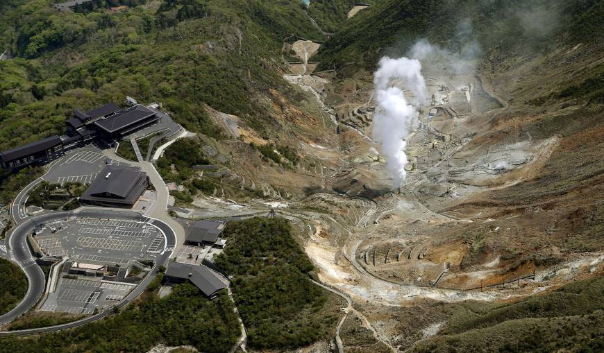 |
Figure 1. An aerial photo taken by the Kyodo News helicopter shows steam rising from the Owakudani hot spring supply facility at Hakoneyama on 7 May 2015. Courtesy of The Japan Times. |
Volcanic tremor lasting for around five minutes started at 0732 on 29 June 2015. At around 1245, fallout was observed in an area up to 1.2 km N and NE of the Owakudani hot spring complex. This fallout was interpreted by JMA to be sediment and debris ejected from a "blowhole" that formed a new fumarole at Owakudani. A field survey conducted on 30 June observed a mound of volcanic ash around the new fumarole. Additionally, volcanic ash was observed near the Owakudani Station of the Hakone Ropeway (a resort tramway) located about 300 m NNW of the hot springs area. As a result of the discovery of the ashfall, JMA raised the Alert Level at 1230 on 30 June from 2 to 3 (Do not approach the volcano).
Additional volcanic ash was found on a camera around 0500 on 1 July. Air shocks that were intermittently observed from 1600 on 29 June to 1 July may have occurred in association with eruptions, the last occurring between 0400 and 0500 on 1 July. A field survey conducted by the Hot Springs Research Institute of Kangawa Prefecture and JMA on 2 July confirmed continued forceful emissions of steam at the new fumarole, which had grown to 20 m in diameter, and was designated Crater 15-1. Three other new fumaroles were also observed around this crater.
No low-frequency earthquakes or volcanic tremors were recorded in July, but active degassing at Crater 15-1 and adjacent fumaroles continued. In a field survey on 6 August 2015, material described as "dark gray soil" was observed around the fumarole, inside the crater rim. Thermal infrared observation showed a high-temperature area on the E side of the crater from August through October. A single, minor seismic event was recorded on 17 August, the first one since 3 July. JMA downgraded the Alert Level at the volcano from 3 (Do not approach the volcano) to 2 (Do not approach the crater) on 11 September, and no further changes in the tiltmeter or strainmeter data were observed after August.
Field surveys on 3 and 29 September indicated that "dark gray soil" continued to be ejected from Crater 15-1, but the scale of the explosions were small and ejection heights were lower than the crater rim. Strong degassing was still occurring at the crater and all other fumaroles. By 20 November the slight weakening of the emissions from Crater 15-1 and overall stability and low seismic activity led JMA to reduce the Volcanic Alert Level further to 1 (Potential for increased activity). Field observations on 7 and 9 December 2015 confirmed continuing strong degassing with plumes to 600 m in the area around Owakudani, but no new ejecta.
Information Contacts: Japan Meteorological Agency (JMA), Otemachi, 1-3-4, Chiyoda-ku Tokyo 100-8122, Japan (URL: http://www.jma.go.jp/); The Mainichi, Japan's National Daily since 1922 (URL: http://mainichi.jp/english/); The Japan Times (URL: http://www.japantimes.co.jp/news/2015/05/07/national/volcano-alert-raised-mount-hakone/#.WHkqQHrcDy1).
2019: May
| October
2015: May
| June
| July
| November
2001: August
On 7 October JMA lowered the Alert Level for Hakoneyama to 1 (the lowest level on a 5-level scale), noting that the number of volcanic earthquakes had decreased to background levels after a spike in seismicity was recorded in May. Inflation had been detected but had become almost stagnant after late August. Fumaroles in the Owakudani hot springs area continued to be active, with gas-and-steam plumes rising 100-400 m above their vents.
Source: Japan Meteorological Agency (JMA)
JMA reported that the number of earthquakes at Hakoneyama increased on 18 May and remained elevated through 27 May. The epicenters were centered around the W bank of Lake Ashinoko and around Komagatake. Global Navigation Satellite Systems (GNSS) data continued to indicate a trend of inflation. The Alert Level remained at 2 (on a 5-level scale).
Source: Japan Meteorological Agency (JMA)
JMA reported that the number of earthquakes at Hakoneyama increased during 18-19 May, with epicenters centered around the W bank of Lake Ashinoko and around Komagatake. Fumaroles in the Owakudani hot springs area continued to be active. Global Navigation Satellite Systems (GNSS) data showed changes in deformation beginning in mid-March. On 19 May JMA raised the Alert Level to 2 (on a 5-level scale). Elevated seismicity continued to be recorded through 21 May.
Source: Japan Meteorological Agency (JMA)
According to a news article from 20 November, JMA lowered the Alert Level for Hakoneyama to 1 (on a scale of 1-5) due to continuing low levels of seismicity.
Source: The Japan Times
On 12 July JMA reported that the webcam continued to record vigorous fumarolic plumes rising from Hakoneyama's Owakudani hot spring area. The Alert Level remained at 3 (on a 5-level scale).
Source: Japan Meteorological Agency (JMA)
According to a news article a drone that surveyed the Owakudani hot spring district at Hakoneyama recorded damage to three hot spring supply facilities; an exclusion zone for visitors was in effect due to increased seismic activity and an Alert Level raise to 2 (on a 5-level scale) on 6 May. At 1230 on 30 June a small-scale eruption occurred and the Alert Level was raised to 3. On 1 July a news article noted another small-scale eruption (occurring between 0400 and 0500), and JMA reported that ash deposits were visible with the webcam. During fieldwork on 2 July, scientists confirmed new fumaroles at Owakudani that were vigorously emitting white plumes; the new fumaroles had formed during 29-30 June. White fumarolic plumes continued to be emitted through 5 July.
Sources: Japan Meteorological Agency (JMA); The Japan Times; The Japan Times
JMA reported that on 29 June scientists visiting Hakoneyama observed new fumaroles in a landslide-prone area, appearing after a possible landslide had occurred. Fresh sediment deposits within 2 km were possibly caused by the formation of the fumaroles. Seismicity began increasing at 1930, and a 5-minute-period of volcanic tremor began at 1932. At 1230 on 30 June a small-scale eruption occurred. The Alert Level was raised to 3 (on a 5-level scale).
Source: Japan Meteorological Agency (JMA)
JMA reported that during 14-17 May seismicity at Hakoneyama remained high. Inclinometer data showed variations related to seismicity, and vigorous steaming from the hot springs was observed. The Alert Level remained at 2 (on a 5-level scale). According to a news article, the ground level in the Owakudani hot spring area had risen 12 cm during 17 April-15 May; the deformation occurred in an area 200 m in diameter. The article also noted that 471 earthquakes were recorded on 15 May, the highest number ever recorded there in one day.
Source: Japan Meteorological Agency (JMA)
On 6 May JMA raised the Alert Level for Hakoneyama from 1 to 2 (on a 5-level scale). Seismicity had increased on 26 April, and on 5 May three events occurred that were Intensity I. Inclinometer data showed variations related to seismicity, and vigorous steaming from the hot springs was observed. Seismicity remained elevated at least through 10 May.
Source: Japan Meteorological Agency (JMA)
Elevated seismicity had been recorded at Hakone during June 2001 to at least 8 August. The seismicity was associated with a small amount of inflation that was centered at the volcano. Earthquake hypocenters occurred at depths less than 5 km beneath the volcano. A small swarm was also recorded under the northern end of the Ashino-ko (caldera lake). JMA noted that the change in activity might not be a precursor to an eruption since similar activity has occurred in the past that was not followed by an eruption.
Source: Volcano Research Center-Earthquake Research Institute (University of Tokyo)
Reports are organized chronologically and indexed below by Month/Year (Publication Volume:Number), and include a one-line summary. Click on the index link or scroll down to read the reports.
Brief earthquake swarm in center of caldera
A swarm of ~300 earthquakes (M <= 2.5) was recorded between 1000 and 1300 on 22 April. Several of the earthquakes, located at 5 km depth in the central part of the caldera, were felt by area residents. Seismicity gradually declined, and had returned to normal by 24 April. No changes in surface activity were observed. Earthquake swarms have been recorded about once a year, including one in August 1990 (M <= 5.1), at the volcano's E foot. Hakone erupted phreatically about 3,000 years ago, and many fumaroles and hot springs remain active.
Information Contacts: JMA.
Small explosions and new fumaroles in the Owakudani thermal area during June 2015
The Hakoneyama volcano includes large calderas, post-caldera domes, and active thermal areas about 80 km SW of Tokyo. Phreatic explosions have been radiocarbon dated to the 12th or 13th centuries CE, and periodic seismic swarms have been recorded since the late 20th century when regular monitoring began. Renewed activity at the Owakudani hot spring area (1 km N of the Kamiyama dome summit), including two small explosions and the formation of several new fumaroles, was reported by the Japan Meteorological Agency (JMA) in 2015. The area is a popular resort destination with golf courses, spas, skiing, and aerial tramways.
Seismic swarms were previously reported in 1991 (BGVN 16:04), 2001, 2011, and 2013. A slight inflation of the volcanic edifice was recorded between December 2012 and March 2013. Increased seismicity and intense steam emissions at Owakudani were observed beginning in April 2015, and on 29 and 30 June 2015 two small explosions from a new fumarole created a mound of ash around the vent and scattered ash a few hundred meters N. Additional ash was observed in the early morning of 1 July. Strong degassing from the fumaroles continued through the end of the year, although seismicity dropped below detection by mid-August, and inflation stopped at the end of August.
Activity during 1991-2014. A swarm of about 300 earthquakes, all less than M 2.5 and located at 5 km depth below the central part of the caldera, was reported by JMA in April 1991 and felt by area residents (BGVN 16:04). Between June and August 2001 elevated seismicity from depths less than 5 km below the surface was associated with a small amount of inflation centered at the volcano; a small swarm was also recorded under the N end of Ashino-ko (Lake Ashi).
A brief period of increased seismicity was again recorded in the few days following the 11 March 2011 Tohoku Earthquake which was centered about 400 km NE. The activity was confined to the area around the Owakudani hot springs. On 21 March 2011, a M 4.2 earthquake occurred around the Komagatake dome (1 km SSE of Kamiyama). Fumes from the Sounjigoku geothermal area on the E side of the volcano were observed rising 50-200 m during March 2011. The tiltmeter network operated by the Hot Springs Research Institute of Kanagawa Prefecture showed no relevant changes resulting from the earthquake.
Between January and March 2013, JMA reported a slight increase in the number of shallow earthquakes in the area between Komagatake and Sengokuhara Hot Spring (4 km NE of Kamiyama dome). Strainmeter and tiltmeter observations recorded a slight inflation of the volcano that began at the end of 2012 and stopped by the end of February 2013.
Activity during 2015. Scientists conducted field surveys on 4-5 April 2015 and observed forceful steam emissions at the Owakudani hot spring complex that continued at least through 8 April. Six small seismic events were recorded on 10 April in the Yumoto area of the city of Hakone (8 km ESE). JMA reported an increased seismicity to tens of daily events at Hakoneyama beginning 26 April 2015. On 5 May, three more small seismic events were recorded in the Yumoto area. This led JMA to raise the Volcano Alert Level from 1 (Normal) to 2 (Do not approach the crater) on a 5-level scale on 6 May. There were 21 additional small seismic events in the Yumoto area during May 2015. The daily total of all seismic events rose significantly to 442 on 15 May, the highest since 2001.
Ground deformation data showed changes attributable to the seismic events. The Mainichi (a daily newspaper) reported on 17 May 2015 that an analysis of satellite data by the Geospatial Information Authority of Japan found that the ground level in a 200-m-diameter area in the Owakudani district rose 12 cm between 17 April and 15 May. Intense steam emissions continued at the Owakudani hot spring supply complex in May (figure 1).
|
Figure 1. An aerial photo taken by the Kyodo News helicopter shows steam rising from the Owakudani hot spring supply facility at Hakoneyama on 7 May 2015. Courtesy of The Japan Times. |
Volcanic tremor lasting for around five minutes started at 0732 on 29 June 2015. At around 1245, fallout was observed in an area up to 1.2 km N and NE of the Owakudani hot spring complex. This fallout was interpreted by JMA to be sediment and debris ejected from a "blowhole" that formed a new fumarole at Owakudani. A field survey conducted on 30 June observed a mound of volcanic ash around the new fumarole. Additionally, volcanic ash was observed near the Owakudani Station of the Hakone Ropeway (a resort tramway) located about 300 m NNW of the hot springs area. As a result of the discovery of the ashfall, JMA raised the Alert Level at 1230 on 30 June from 2 to 3 (Do not approach the volcano).
Additional volcanic ash was found on a camera around 0500 on 1 July. Air shocks that were intermittently observed from 1600 on 29 June to 1 July may have occurred in association with eruptions, the last occurring between 0400 and 0500 on 1 July. A field survey conducted by the Hot Springs Research Institute of Kangawa Prefecture and JMA on 2 July confirmed continued forceful emissions of steam at the new fumarole, which had grown to 20 m in diameter, and was designated Crater 15-1. Three other new fumaroles were also observed around this crater.
No low-frequency earthquakes or volcanic tremors were recorded in July, but active degassing at Crater 15-1 and adjacent fumaroles continued. In a field survey on 6 August 2015, material described as "dark gray soil" was observed around the fumarole, inside the crater rim. Thermal infrared observation showed a high-temperature area on the E side of the crater from August through October. A single, minor seismic event was recorded on 17 August, the first one since 3 July. JMA downgraded the Alert Level at the volcano from 3 (Do not approach the volcano) to 2 (Do not approach the crater) on 11 September, and no further changes in the tiltmeter or strainmeter data were observed after August.
Field surveys on 3 and 29 September indicated that "dark gray soil" continued to be ejected from Crater 15-1, but the scale of the explosions were small and ejection heights were lower than the crater rim. Strong degassing was still occurring at the crater and all other fumaroles. By 20 November the slight weakening of the emissions from Crater 15-1 and overall stability and low seismic activity led JMA to reduce the Volcanic Alert Level further to 1 (Potential for increased activity). Field observations on 7 and 9 December 2015 confirmed continuing strong degassing with plumes to 600 m in the area around Owakudani, but no new ejecta.
Information Contacts: Japan Meteorological Agency (JMA), Otemachi, 1-3-4, Chiyoda-ku Tokyo 100-8122, Japan (URL: http://www.jma.go.jp/); The Mainichi, Japan's National Daily since 1922 (URL: http://mainichi.jp/english/); The Japan Times (URL: http://www.japantimes.co.jp/news/2015/05/07/national/volcano-alert-raised-mount-hakone/#.WHkqQHrcDy1).
|
|
||||||||||||||||||||||||||
There is data available for 8 confirmed Holocene eruptive periods.
2015 Jun 29 - 2015 Jul 1 Confirmed Eruption (Explosive / Effusive) VEI: 1
| Episode 1 | Eruption (Explosive / Effusive) | Owakudani hot springs, 1 km N of Kamiyama dome | |||||||||||||||||||||||||||||||||||||||||||||||||||||||||||||||||||||
|---|---|---|---|---|---|---|---|---|---|---|---|---|---|---|---|---|---|---|---|---|---|---|---|---|---|---|---|---|---|---|---|---|---|---|---|---|---|---|---|---|---|---|---|---|---|---|---|---|---|---|---|---|---|---|---|---|---|---|---|---|---|---|---|---|---|---|---|---|---|---|
| 2015 Jun 29 - 2015 Jul 1 | Evidence from Observations: Reported | |||||||||||||||||||||||||||||||||||||||||||||||||||||||||||||||||||||
|
List of 12 Events for Episode 1 at Owakudani hot springs, 1 km N of Kamiyama dome
|
||||||||||||||||||||||||||||||||||||||||||||||||||||||||||||||||||||||
1170 ± 100 years Confirmed Eruption (Explosive / Effusive)
| Episode 1 | Eruption (Explosive / Effusive) | Owakudani, Hk-Ow 3-5 tephras | ||||||||||||||||||||||||||||||||||||||||||||
|---|---|---|---|---|---|---|---|---|---|---|---|---|---|---|---|---|---|---|---|---|---|---|---|---|---|---|---|---|---|---|---|---|---|---|---|---|---|---|---|---|---|---|---|---|---|
| 1170 ± 100 years - Unknown | Evidence from Isotopic: 14C (calibrated) | ||||||||||||||||||||||||||||||||||||||||||||
|
List of 7 Events for Episode 1 at Owakudani, Hk-Ow 3-5 tephras
|
|||||||||||||||||||||||||||||||||||||||||||||
0050 BCE (?) Confirmed Eruption (Explosive / Effusive)
| Episode 1 | Eruption (Explosive / Effusive) | NE of Kamiyama, Hk-Ow2 tephra | |||||||||||||||||||||||||||||
|---|---|---|---|---|---|---|---|---|---|---|---|---|---|---|---|---|---|---|---|---|---|---|---|---|---|---|---|---|---|---|
| 0050 BCE (?) - Unknown | Evidence from Correlation: Tephrochronology | |||||||||||||||||||||||||||||
|
List of 4 Events for Episode 1 at NE of Kamiyama, Hk-Ow2 tephra
|
||||||||||||||||||||||||||||||
1050 BCE (?) Confirmed Eruption (Explosive / Effusive)
| Episode 1 | Eruption (Explosive / Effusive) | NE of Kamiyama, Hk-Ow1 tephra | ||||||||||||||||||||||||
|---|---|---|---|---|---|---|---|---|---|---|---|---|---|---|---|---|---|---|---|---|---|---|---|---|---|
| 1050 BCE (?) - Unknown | Evidence from Correlation: Tephrochronology | ||||||||||||||||||||||||
|
List of 3 Events for Episode 1 at NE of Kamiyama, Hk-Ow1 tephra
|
|||||||||||||||||||||||||
1200 BCE (?) Confirmed Eruption (Explosive / Effusive) VEI: 2
| Episode 1 | Eruption (Explosive / Effusive) | NW side of Kami-yama (Kanmuriga-take) | |||||||||||||||||||||||||||||||||||||||
|---|---|---|---|---|---|---|---|---|---|---|---|---|---|---|---|---|---|---|---|---|---|---|---|---|---|---|---|---|---|---|---|---|---|---|---|---|---|---|---|---|
| 1200 BCE (?) - Unknown | Evidence from Isotopic: 14C (calibrated) | |||||||||||||||||||||||||||||||||||||||
|
List of 6 Events for Episode 1 at NW side of Kami-yama (Kanmuriga-take)
|
||||||||||||||||||||||||||||||||||||||||
1400 BCE ± 100 years Confirmed Eruption (Explosive / Effusive)
| Episode 1 | Eruption (Explosive / Effusive) | NW side of Kami-yama (Kanmuriga-take) | ||||||||||||||||||||||||
|---|---|---|---|---|---|---|---|---|---|---|---|---|---|---|---|---|---|---|---|---|---|---|---|---|---|
| 1400 BCE ± 100 years - Unknown | Evidence from Isotopic: 14C (calibrated) | ||||||||||||||||||||||||
|
List of 3 Events for Episode 1 at NW side of Kami-yama (Kanmuriga-take)
|
|||||||||||||||||||||||||
3700 BCE ± 100 years Confirmed Eruption (Explosive / Effusive) VEI: 1
| Episode 1 | Eruption (Explosive / Effusive) | Futago-yama | ||||||||||||||||||||||||
|---|---|---|---|---|---|---|---|---|---|---|---|---|---|---|---|---|---|---|---|---|---|---|---|---|---|
| 3700 BCE ± 100 years - Unknown | Evidence from Isotopic: 14C (calibrated) | ||||||||||||||||||||||||
|
List of 3 Events for Episode 1 at Futago-yama
|
|||||||||||||||||||||||||
6000 BCE ± 100 years Confirmed Eruption (Explosive / Effusive) VEI: 3
| Episode 1 | Eruption (Explosive / Effusive) | Kami-yama, Hk-Km5 tephra | ||||||||||||||||||||||||
|---|---|---|---|---|---|---|---|---|---|---|---|---|---|---|---|---|---|---|---|---|---|---|---|---|---|
| 6000 BCE ± 100 years - Unknown | Evidence from Isotopic: 14C (calibrated) | ||||||||||||||||||||||||
|
List of 3 Events for Episode 1 at Kami-yama, Hk-Km5 tephra
|
|||||||||||||||||||||||||
This compilation of synonyms and subsidiary features may not be comprehensive. Features are organized into four major categories: Cones, Craters, Domes, and Thermal Features. Synonyms of features appear indented below the primary name. In some cases additional feature type, elevation, or location details are provided.
Synonyms |
||||
| Hakone | ||||
Craters |
||||
| Feature Name | Feature Type | Elevation | Latitude | Longitude |
| Hakone | Caldera | 660 m | 35° 15' 45.00" N | 139° 0' 0.00" E |
Domes |
||||
| Feature Name | Feature Type | Elevation | Latitude | Longitude |
| Byobuyama | Dome | 955 m | 35° 11' 50.00" N | 139° 2' 18.00" E |
| Futagoyama
Futago-yama |
Dome | 1063 m | 35° 12' 27.00" N | 139° 2' 54.00" E |
| Kamiyama
Kami-yama |
Dome | 1438 m | 35° 14' 0.00" N | 139° 1' 15.00" E |
| Komagatake
Komaga-take |
Dome | 1359 m | 35° 13' 30.00" N | 139° 1' 30.00" E |
| Kozukayama
Kozuka-yama |
Dome | 865 m | 35° 15' 34.00" N | 139° 1' 20.00" E |
Thermal |
||||
| Feature Name | Feature Type | Elevation | Latitude | Longitude |
| Owakudani | Thermal | 1044 m | 35° 14' 38.00" N | 139° 1' 20.00" E |
| Sounzan | Thermal | 1066 m | 35° 14' 23.00" N | 139° 1' 47.00" E |
 Hakoneyama volcano, seen here from the W, is a broad volcano with two large calderas. A group of lava domes formed in the center of the caldera. The highest dome, Kamiyama, forms the high point of the complex, topped by clouds in the center of the photo. The caldera formed during two large Pleistocene eruptions. An eruption took place around 3,000 years ago and seismic swarms have occurred frequently during the 20th century.
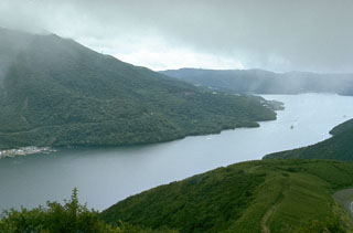 The flanks of a group of post-caldera lava domes are to the left above Lake Ashi in SW Hakone caldera. Lake Ashi formed when an avalanche from Kamiyama, the highest of the central lava domes, blocked river valleys that drain to the E through a breach in the caldera wall.
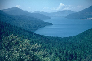 Lake Ashi, seen here from the SE, occupies the SW corner of Hakone caldera. Hakoneyama contains two calderas, the largest of which is 10 x 11 km. The arcuate caldera rim is to the left and the flanks of a group of post-caldera cones form the right-hand shoreline. Post-caldera eruptions have constructed a half dozen lava domes along a SW-NE trend across the center of the calderas. An eruption took place around 3,000 years ago and seismic swarms occurred frequently during the 20th century.
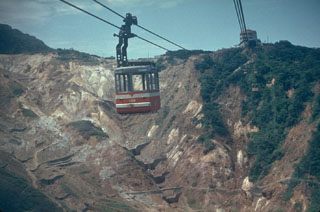 Aerial cable cars stretching across Owakudani provide a view of one of the many thermal areas in Hakone caldera. Hot spring resorts surround a complex of lava domes in the center of the caldera.
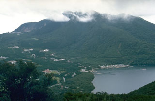 Kamiyama, the highest of a group of lava domes forming the central cone complex of Hakoneyama caldera, rises E of Ashinoko (Lake Ashi). The lake formed about 3,100 years ago when collapse of the NW side of Kamiyama dammed the Hayakawa river valley at the N end of the lake (lower left). Dome growth at Kamiyama occurred about 2,900 years ago.
The following 60 samples associated with this volcano can be found in the Smithsonian's NMNH Department of Mineral Sciences collections, and may be availble for research (contact the Rock and Ore Collections Manager). Catalog number links will open a window with more information.
| Catalog Number | Sample Description | Lava Source | Collection Date |
|---|---|---|---|
| NMNH 105869-00 | Pigeonite | -- | -- |
| NMNH 106410-00 | Hypersthene | -- | -- |
| NMNH 107431-00 | Pargasite | -- | -- |
| NMNH 108936 | Augite Andesite | KAMI-YAMA CONE | -- |
| NMNH 108937 | Dacite | -- | -- |
| NMNH 108938 | Augite Andesite | -- | -- |
| NMNH 108939 | Olivine Basalt | -- | -- |
| NMNH 108942 | Andesite Pumice | -- | -- |
| NMNH 108943 | Dacitic Andesite | MAKU-YAMA DOME | -- |
| NMNH 108944 | Hypersthene Andesite | KINTOKI-SAN CONE | -- |
| NMNH 108945 | Andesite | -- | -- |
| NMNH 108949 | Hypersthene Andesite | -- | -- |
| NMNH 108950 | Hypersthene Andesite | -- | -- |
| NMNH 108951 | Hypersthene Andesite | -- | -- |
| NMNH 108955 | Hypersthene Andesite | -- | -- |
| NMNH 108956 | Augite Andesite | KAMIHUTAGO-YAMA CONE | -- |
| NMNH 108957 | Andesite | -- | -- |
| NMNH 108958 | Hornblende Andesite | -- | -- |
| NMNH 108960 | Welded Tuff | -- | -- |
| NMNH 108961 | Augite Andesite | -- | -- |
| NMNH 108965 | Hypersthene Andesite | -- | -- |
| NMNH 108966 | Augite Andesite | -- | -- |
| NMNH 108967 | Hypersthene Andesite | -- | -- |
| NMNH 108971 | Augite Andesite | -- | -- |
| NMNH 108972 | Hypersthene Andesite | -- | -- |
| NMNH 108975 | Hypersthene Andesite | -- | -- |
| NMNH 108976 | Augite Andesite | -- | -- |
| NMNH 108977 | Hypersthene Andesite | -- | -- |
| NMNH 112898 | Pigeonite Andesite | -- | -- |
| NMNH 112899 | Pyroxene Andesite | -- | -- |
| NMNH 112899 | Pyroxene Andesite | -- | -- |
| NMNH 112900 | Andesite | -- | -- |
| NMNH 112900 | Andesite | -- | -- |
| NMNH 112901 | Hypersthene Andesite | -- | -- |
| NMNH 112901 | Hypersthene Andesite | -- | -- |
| NMNH 112902 | Hypersthene Andesite | -- | -- |
| NMNH 112902 | Hypersthene Andesite | -- | -- |
| NMNH 112903 | Hypersthene Dacite | -- | -- |
| NMNH 112903 | Hypersthene Dacite | -- | -- |
| NMNH 112904 | Augite Andesite | SIMOHUTAGO-YAMA CONE | -- |
| NMNH 112904 | Augite Andesite | SIMOHUTAGO-YAMA CONE | -- |
| NMNH 112904 | Augite Andesite | SIMOHUTAGO-YAMA CONE | -- |
| NMNH 112905 | Hypersthene Andesite | KOMA-GATAKE CONE | -- |
| NMNH 112905 | Hypersthene Andesite | KOMA-GATAKE CONE | -- |
| NMNH 113055 | Hypersthene Andesite | -- | -- |
| NMNH 117801-12 | Augite-Pigeonite-Hypersthene Andesite | Old Somma | -- |
| NMNH 117801-18 | Augite Andesite | Simohutago-yama | -- |
| NMNH 117801-19 | Augite Andesite | Simohutago-yama | -- |
| NMNH 117801-21 | Hypersthene-Hornblende-Quartz Dacite | -- | -- |
| NMNH 117801-25 | Olivine Andesite | Old Somma | -- |
| NMNH 117801-27 | Obsidian | -- | -- |
| NMNH 117801-30 | Hypersthene-Olivine Andesite | Old Somma | -- |
| NMNH 117801-32 | Hypersthene Dacite | -- | -- |
| NMNH 117801-35 | Pumice | -- | -- |
| NMNH 117801-4 | Augite-Hypersthene Andesite | Old Somma | -- |
| NMNH 117801-5 | Hornblende-Hypersthene Andesite | -- | -- |
| NMNH 117801-6 | Andesite | Old Somma | -- |
| NMNH M6542-00 | Fayalite | -- | -- |
| NMNH M6543-00 | Fayalite | -- | -- |
| NMNH M6544-00 | Fayalite | -- | -- |
| Copernicus Browser | The Copernicus Browser replaced the Sentinel Hub Playground browser in 2023, to provide access to Earth observation archives from the Copernicus Data Space Ecosystem, the main distribution platform for data from the EU Copernicus missions. |
| MIROVA | Middle InfraRed Observation of Volcanic Activity (MIROVA) is a near real time volcanic hot-spot detection system based on the analysis of MODIS (Moderate Resolution Imaging Spectroradiometer) data. In particular, MIROVA uses the Middle InfraRed Radiation (MIR), measured over target volcanoes, in order to detect, locate and measure the heat radiation sourced from volcanic activity. |
| MODVOLC Thermal Alerts | Using infrared satellite Moderate Resolution Imaging Spectroradiometer (MODIS) data, scientists at the Hawai'i Institute of Geophysics and Planetology, University of Hawai'i, developed an automated system called MODVOLC to map thermal hot-spots in near real time. For each MODIS image, the algorithm automatically scans each 1 km pixel within it to check for high-temperature hot-spots. When one is found the date, time, location, and intensity are recorded. MODIS looks at every square km of the Earth every 48 hours, once during the day and once during the night, and the presence of two MODIS sensors in space allows at least four hot-spot observations every two days. Each day updated global maps are compiled to display the locations of all hot spots detected in the previous 24 hours. There is a drop-down list with volcano names which allow users to 'zoom-in' and examine the distribution of hot-spots at a variety of spatial scales. |
|
WOVOdat
Single Volcano View Temporal Evolution of Unrest Side by Side Volcanoes |
WOVOdat is a database of volcanic unrest; instrumentally and visually recorded changes in seismicity, ground deformation, gas emission, and other parameters from their normal baselines. It is sponsored by the World Organization of Volcano Observatories (WOVO) and presently hosted at the Earth Observatory of Singapore.
GVMID Data on Volcano Monitoring Infrastructure The Global Volcano Monitoring Infrastructure Database GVMID, is aimed at documenting and improving capabilities of volcano monitoring from the ground and space. GVMID should provide a snapshot and baseline view of the techniques and instrumentation that are in place at various volcanoes, which can be use by volcano observatories as reference to setup new monitoring system or improving networks at a specific volcano. These data will allow identification of what monitoring gaps exist, which can be then targeted by remote sensing infrastructure and future instrument deployments. |
| Volcanic Hazard Maps | The IAVCEI Commission on Volcanic Hazards and Risk has a Volcanic Hazard Maps database designed to serve as a resource for hazard mappers (or other interested parties) to explore how common issues in hazard map development have been addressed at different volcanoes, in different countries, for different hazards, and for different intended audiences. In addition to the comprehensive, searchable Volcanic Hazard Maps Database, this website contains information about diversity of volcanic hazard maps, illustrated using examples from the database. This site is for educational purposes related to volcanic hazard maps. Hazard maps found on this website should not be used for emergency purposes. For the most recent, official hazard map for a particular volcano, please seek out the proper institutional authorities on the matter. |
| IRIS seismic stations/networks | Incorporated Research Institutions for Seismology (IRIS) Data Services map showing the location of seismic stations from all available networks (permanent or temporary) within a radius of 0.18° (about 20 km at mid-latitudes) from the given location of Hakoneyama. Users can customize a variety of filters and options in the left panel. Note that if there are no stations are known the map will default to show the entire world with a "No data matched request" error notice. |
| UNAVCO GPS/GNSS stations | Geodetic Data Services map from UNAVCO showing the location of GPS/GNSS stations from all available networks (permanent or temporary) within a radius of 20 km from the given location of Hakoneyama. Users can customize the data search based on station or network names, location, and time window. Requires Adobe Flash Player. |
| DECADE Data | The DECADE portal, still in the developmental stage, serves as an example of the proposed interoperability between The Smithsonian Institution's Global Volcanism Program, the Mapping Gas Emissions (MaGa) Database, and the EarthChem Geochemical Portal. The Deep Earth Carbon Degassing (DECADE) initiative seeks to use new and established technologies to determine accurate global fluxes of volcanic CO2 to the atmosphere, but installing CO2 monitoring networks on 20 of the world's 150 most actively degassing volcanoes. The group uses related laboratory-based studies (direct gas sampling and analysis, melt inclusions) to provide new data for direct degassing of deep earth carbon to the atmosphere. |
| Large Eruptions of Hakoneyama | Information about large Quaternary eruptions (VEI >= 4) is cataloged in the Large Magnitude Explosive Volcanic Eruptions (LaMEVE) database of the Volcano Global Risk Identification and Analysis Project (VOGRIPA). |
| EarthChem | EarthChem develops and maintains databases, software, and services that support the preservation, discovery, access and analysis of geochemical data, and facilitate their integration with the broad array of other available earth science parameters. EarthChem is operated by a joint team of disciplinary scientists, data scientists, data managers and information technology developers who are part of the NSF-funded data facility Integrated Earth Data Applications (IEDA). IEDA is a collaborative effort of EarthChem and the Marine Geoscience Data System (MGDS). |

