
According to the Japan Meteorological Agency (JMA) discolored water around Sumisujima was observed on 18 September during an overflight conducted by the Japan Coast Guard. An area of pale-blue to white discolored water extended about 1.8 km NW of the N coast of the island. A very small amount of grayish-white material was floating in the same area as the discolored water and along the W coast. At 1100 on 19 September JMA issued an “eruption warning” noting that an eruption could affect the surround waters of the island.
Source: Japan Meteorological Agency (JMA)
Discolored water with sulfur odor reported by fishing boat
[The following provides additional information about the 7 October 1992 observation.]
"Shira-ne, a small rock mass of two pyroxene andesite 7.7 m below sea level, located about 7.5 km NE of Smith Rocks and about 500 km S of Tokyo, forms an E part of a submarine caldera about 8 km in diameter (figure 1). Smith Rocks, 136 m a.s.l., forming S rim of the caldera are of olivine basalt.
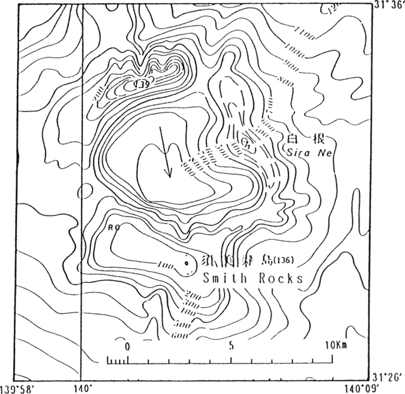 |
Figure 1. Submarine topography of Shira-ne and nearby area. |
"On October 7, 1992, yellow discolored water smelling sulfur was reported by a fishing boat, Daini-Odamaru, suggesting a submarine volcanic activity. The area of discoloration was 6 km long and 30 m wide."
"Reference: Hydrographic Department, Japan Maritime Safety Agency (1992): Recent activity of submarine volcanoes and volcanic islands. Rept. Coordinating Committee for Predication of Volcanic Eruption, No. 54, p. 77.
"(Communication from: H. Furukawa, Japan Maritime Safety Agency, Tsukiji 5-3-1, Chuo-ku, Tokyo 104, Japan.)"
Reference. Bulletin of Volcanic Eruptions, 1995, Annual Report of the World Volcanic Eruptions in 1992: Volcanological Society of Japan, no. 32, p. 134-135.
Information Contacts:
According to the Japan Meteorological Agency (JMA) discolored water around Sumisujima was observed on 18 September during an overflight conducted by the Japan Coast Guard. An area of pale-blue to white discolored water extended about 1.8 km NW of the N coast of the island. A very small amount of grayish-white material was floating in the same area as the discolored water and along the W coast. At 1100 on 19 September JMA issued an “eruption warning” noting that an eruption could affect the surround waters of the island.
Source: Japan Meteorological Agency (JMA)
The Japan Coast Guard reported that an area of discolored water, brown to yellow-green in color, was visible about 300 m E of the E coast of Sumisujima on 18 July. The report noted that areas of discolored water had occasionally been seen in the vicinity of the island since 2017, though usually characterized as pale blue to white and smaller in size. Sailors were warned to exercise caution in the area.
Source: Japan Coast Guard
Reports are organized chronologically and indexed below by Month/Year (Publication Volume:Number), and include a one-line summary. Click on the index link or scroll down to read the reports.
Small zone of discolored water
A zone of discolored yellowish water 30 m [wide] and [6 km long] was observed by fishing crews at around 1100 on 7 October. A JMSA overflight on 9 October showed no anomaly. The volcano last erupted in 1916, ejecting tephra. Discoloration was seen at the shore and near the island in 1975, 1976, 1977, 1989, and August 1992.
Information Contacts: JMA; JMSA.
Discolored water with sulfur odor reported by fishing boat
[The following provides additional information about the 7 October 1992 observation.]
"Shira-ne, a small rock mass of two pyroxene andesite 7.7 m below sea level, located about 7.5 km NE of Smith Rocks and about 500 km S of Tokyo, forms an E part of a submarine caldera about 8 km in diameter (figure 1). Smith Rocks, 136 m a.s.l., forming S rim of the caldera are of olivine basalt.
|
Figure 1. Submarine topography of Shira-ne and nearby area. |
"On October 7, 1992, yellow discolored water smelling sulfur was reported by a fishing boat, Daini-Odamaru, suggesting a submarine volcanic activity. The area of discoloration was 6 km long and 30 m wide."
"Reference: Hydrographic Department, Japan Maritime Safety Agency (1992): Recent activity of submarine volcanoes and volcanic islands. Rept. Coordinating Committee for Predication of Volcanic Eruption, No. 54, p. 77.
"(Communication from: H. Furukawa, Japan Maritime Safety Agency, Tsukiji 5-3-1, Chuo-ku, Tokyo 104, Japan.)"
Reference. Bulletin of Volcanic Eruptions, 1995, Annual Report of the World Volcanic Eruptions in 1992: Volcanological Society of Japan, no. 32, p. 134-135.
Information Contacts:
|
|
||||||||||||||||||||||||||||
There is data available for 2 confirmed eruptive periods.
[ 2024 Sep 18 - 2024 Oct 5 ] Uncertain Eruption
| Episode 1 | Uncertain | ||||
|---|---|---|---|---|
| 2024 Sep 18 - 2024 Oct 5 | Evidence from Observations: Reported | |||
| According to the Japan Meteorological Agency discolored water around Sumisujima was observed on 18 September 2024 during an overflight conducted by the Japan Coast Guard. An area of pale-blue to white discolored water extended about 1.8 km NW of the N coast of the island. A very small amount of grayish-white material was floating in the same area as the discolored water and along the W coast. | ||||
[ 2005 Mar 8 - 2005 Mar 8 ] Uncertain Eruption
| Episode 1 | Eruption (Explosive / Effusive) | ||||||||||||||
|---|---|---|---|---|---|---|---|---|---|---|---|---|---|---|
| 2005 Mar 8 - 2005 Mar 8 | Evidence from Unknown | |||||||||||||
|
List of 1 Events for Episode 1
|
||||||||||||||
[ 2003 Nov 6 - 2003 Nov 6 ] Uncertain Eruption
| Episode 1 | Eruption (Explosive / Effusive) | ||||||||||||||
|---|---|---|---|---|---|---|---|---|---|---|---|---|---|---|
| 2003 Nov 6 - 2003 Nov 6 | Evidence from Unknown | |||||||||||||
|
List of 1 Events for Episode 1
|
||||||||||||||
[ 2002 Sep 4 - 2002 Sep 4 ] Uncertain Eruption
| Episode 1 | Eruption (Explosive / Effusive) | ||||||||||||||
|---|---|---|---|---|---|---|---|---|---|---|---|---|---|---|
| 2002 Sep 4 - 2002 Sep 4 | Evidence from Unknown | |||||||||||||
|
List of 1 Events for Episode 1
|
||||||||||||||
[ 2001 Oct 31 - 2002 Feb 28 ] Uncertain Eruption
| Episode 1 | Eruption (Explosive / Effusive) | ||||||||||||||
|---|---|---|---|---|---|---|---|---|---|---|---|---|---|---|
| 2001 Oct 31 - 2002 Feb 28 | Evidence from Unknown | |||||||||||||
|
List of 1 Events for Episode 1
|
||||||||||||||
[ 2000 Oct 30 - 2000 Oct 30 ] Uncertain Eruption
| Episode 1 | Eruption (Explosive / Effusive) | ||||||||||||||
|---|---|---|---|---|---|---|---|---|---|---|---|---|---|---|
| 2000 Oct 30 - 2000 Oct 30 | Evidence from Unknown | |||||||||||||
|
List of 1 Events for Episode 1
|
||||||||||||||
[ 1998 Oct 27 - 1999 Jan 13 ] Uncertain Eruption
| Episode 1 | Eruption (Explosive / Effusive) | ||||||||||||||
|---|---|---|---|---|---|---|---|---|---|---|---|---|---|---|
| 1998 Oct 27 - 1999 Jan 13 | Evidence from Unknown | |||||||||||||
|
List of 1 Events for Episode 1
|
||||||||||||||
[ 1997 Nov 21 - 1997 Nov 21 ] Uncertain Eruption
| Episode 1 | Eruption (Explosive / Effusive) | ||||||||||||||
|---|---|---|---|---|---|---|---|---|---|---|---|---|---|---|
| 1997 Nov 21 - 1997 Nov 21 | Evidence from Unknown | |||||||||||||
|
List of 1 Events for Episode 1
|
||||||||||||||
[ 1996 Jan 22 - 1996 Jan 22 ] Uncertain Eruption
| Episode 1 | Eruption (Explosive / Effusive) | ||||||||||||||
|---|---|---|---|---|---|---|---|---|---|---|---|---|---|---|
| 1996 Jan 22 - 1996 Jan 22 | Evidence from Unknown | |||||||||||||
|
List of 1 Events for Episode 1
|
||||||||||||||
[ 1995 Jul 5 - 1995 Jul 7 ] Uncertain Eruption
| Episode 1 | Eruption (Explosive / Effusive) | ||||||||||||||
|---|---|---|---|---|---|---|---|---|---|---|---|---|---|---|
| 1995 Jul 5 - 1995 Jul 7 | Evidence from Unknown | |||||||||||||
|
List of 1 Events for Episode 1
|
||||||||||||||
[ 1994 Jul 27 - 1994 Jul 27 ] Uncertain Eruption
| Episode 1 | Eruption (Explosive / Effusive) | ||||||||||||||
|---|---|---|---|---|---|---|---|---|---|---|---|---|---|---|
| 1994 Jul 27 - 1994 Jul 27 | Evidence from Unknown | |||||||||||||
|
List of 1 Events for Episode 1
|
||||||||||||||
[ 1994 Jan 17 - 1994 Jan 17 ] Uncertain Eruption
| Episode 1 | Eruption (Explosive / Effusive) | ||||||||||||||
|---|---|---|---|---|---|---|---|---|---|---|---|---|---|---|
| 1994 Jan 17 - 1994 Jan 17 | Evidence from Unknown | |||||||||||||
|
List of 1 Events for Episode 1
|
||||||||||||||
[ 1993 Sep 8 - 1993 Sep 10 ] Uncertain Eruption
| Episode 1 | Eruption (Explosive / Effusive) | ||||||||||||||
|---|---|---|---|---|---|---|---|---|---|---|---|---|---|---|
| 1993 Sep 8 - 1993 Sep 10 | Evidence from Unknown | |||||||||||||
|
List of 1 Events for Episode 1
|
||||||||||||||
[ 1992 Aug 5 - 1992 Oct 7 ] Uncertain Eruption
| Episode 1 | Eruption (Explosive / Effusive) | Shirane (7.5 km NE of Smith Rocks) | |||||||||||||
|---|---|---|---|---|---|---|---|---|---|---|---|---|---|---|
| 1992 Aug 5 - 1992 Oct 7 | Evidence from Unknown | |||||||||||||
|
List of 1 Events for Episode 1 at Shirane (7.5 km NE of Smith Rocks)
|
||||||||||||||
[ 1991 Nov 5 - 1991 Nov 5 ] Uncertain Eruption
| Episode 1 | Eruption (Explosive / Effusive) | ||||||||||||||
|---|---|---|---|---|---|---|---|---|---|---|---|---|---|---|
| 1991 Nov 5 - 1991 Nov 5 | Evidence from Unknown | |||||||||||||
|
List of 1 Events for Episode 1
|
||||||||||||||
[ 1989 Jul 18 - 1989 Jul 18 ] Uncertain Eruption
| Episode 1 | Eruption (Explosive / Effusive) | ||||||||||||||
|---|---|---|---|---|---|---|---|---|---|---|---|---|---|---|
| 1989 Jul 18 - 1989 Jul 18 | Evidence from Unknown | |||||||||||||
|
List of 1 Events for Episode 1
|
||||||||||||||
[ 1989 Jan 18 - 1989 Jan 18 ] Uncertain Eruption
| Episode 1 | Eruption (Explosive / Effusive) | ||||||||||||||
|---|---|---|---|---|---|---|---|---|---|---|---|---|---|---|
| 1989 Jan 18 - 1989 Jan 18 | Evidence from Unknown | |||||||||||||
|
List of 1 Events for Episode 1
|
||||||||||||||
[ 1977 Oct 16 ± 15 days - 1977 Oct 16 ± 15 days ] Uncertain Eruption
| Episode 1 | Eruption (Explosive / Effusive) | ||||||||||||||
|---|---|---|---|---|---|---|---|---|---|---|---|---|---|---|
| 1977 Oct 16 ± 15 days - 1977 Oct 16 ± 15 days | Evidence from Unknown | |||||||||||||
|
List of 1 Events for Episode 1
|
||||||||||||||
[ 1976 Aug 16 ± 15 days - 1976 Aug 16 ± 15 days ] Uncertain Eruption
| Episode 1 | Eruption (Explosive / Effusive) | ||||||||||||||
|---|---|---|---|---|---|---|---|---|---|---|---|---|---|---|
| 1976 Aug 16 ± 15 days - 1976 Aug 16 ± 15 days | Evidence from Unknown | |||||||||||||
|
List of 1 Events for Episode 1
|
||||||||||||||
[ 1975 Aug 13 - 1975 Sep 26 ] Uncertain Eruption
| Episode 1 | Eruption (Explosive / Effusive) | ||||||||||||||
|---|---|---|---|---|---|---|---|---|---|---|---|---|---|---|
| 1975 Aug 13 - 1975 Sep 26 | Evidence from Unknown | |||||||||||||
|
List of 1 Events for Episode 1
|
||||||||||||||
[ 1974 Jul 6 - 1974 Jul 6 ] Uncertain Eruption
| Episode 1 | Eruption (Explosive / Effusive) | ||||||||||||||
|---|---|---|---|---|---|---|---|---|---|---|---|---|---|---|
| 1974 Jul 6 - 1974 Jul 6 | Evidence from Unknown | |||||||||||||
|
List of 1 Events for Episode 1
|
||||||||||||||
1916 Jun 21 Confirmed Eruption (Explosive / Effusive) VEI: 0
| Episode 1 | Eruption (Explosive / Effusive) | Just west of Smith Rock | |||||||||||||
|---|---|---|---|---|---|---|---|---|---|---|---|---|---|---|
| 1916 Jun 21 - Unknown | Evidence from Observations: Reported | |||||||||||||
|
List of 1 Events for Episode 1 at Just west of Smith Rock
|
||||||||||||||
[ 1873 ] Uncertain Eruption
| Episode 1 | Eruption (Explosive / Effusive) | 31.28 N 139.92 E | |||||||||||||
|---|---|---|---|---|---|---|---|---|---|---|---|---|---|---|
| 1873 - Unknown | Evidence from Unknown | |||||||||||||
|
List of 1 Events for Episode 1 at 31.28 N 139.92 E
|
||||||||||||||
1870 May Confirmed Eruption (Explosive / Effusive) VEI: 2
| Episode 1 | Eruption (Explosive / Effusive) | 18 km SW of Smith Rock | ||||||||||||||||||
|---|---|---|---|---|---|---|---|---|---|---|---|---|---|---|---|---|---|---|---|
| 1870 May - Unknown | Evidence from Observations: Reported | ||||||||||||||||||
|
List of 2 Events for Episode 1 at 18 km SW of Smith Rock
|
|||||||||||||||||||
[ 1672 (?) ] Uncertain Eruption
| Episode 1 | Eruption (Explosive / Effusive) | 31.58 N 140.25 E | |||||||||||||
|---|---|---|---|---|---|---|---|---|---|---|---|---|---|---|
| 1672 (?) - Unknown | Evidence from Unknown | |||||||||||||
|
List of 1 Events for Episode 1 at 31.58 N 140.25 E
|
||||||||||||||
This compilation of synonyms and subsidiary features may not be comprehensive. Features are organized into four major categories: Cones, Craters, Domes, and Thermal Features. Synonyms of features appear indented below the primary name. In some cases additional feature type, elevation, or location details are provided.
Synonyms |
||||
| Sumisu-jima | Sumisu-sho | Smith Rocks | ||||
Cones |
||||
| Feature Name | Feature Type | Elevation | Latitude | Longitude |
| Shirane | Submarine cone | -8 m | ||
| Sumisu Dai-ichi Knoll
Sumisu Knoll No. 1 |
Submarine cone | |||
| Sumisu Dai-ni Knoll
Sumisu Knoll No. 2 |
Submarine cone | |||
| Sumisujima | Cone | 136 m | 31° 26' 9.00" N | 140° 3' 13.00" E |
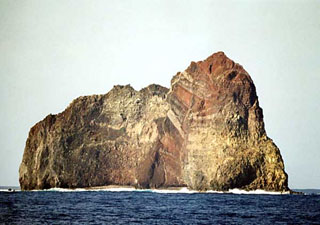 Wave erosion has exposed the spectacular stratigraphy of Sumisujima, a steep-sided pinnacle that is a remnant of the outer southern flank of a submarine caldera 6-9 km wide. Intrusive rocks, dikes, tephra layers, and breccias are visible in this view of the eastern side of the pinnacle. Submarine eruptions have been reported from a number of locations near here, the last of which occurred in 1916. Water discoloration has been frequently observed nearby since the 1970s.
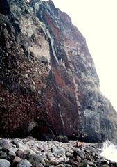 Geologists stand on the narrow cobble beach at the NE base of Sumisujima. Vertical light-colored dikes cut intrusive rocks at the lower right alogn with oxidized tephra layers, breccias, and lava flows forming the pinnacle. The spire is an eroded remnant of the pre-caldera volcano on the outer southern flank of a large submarine caldera. A large segment of the eastern side of the pinnacle previously slumped into the sea.
There are no samples for Sumisujima in the Smithsonian's NMNH Department of Mineral Sciences Rock and Ore collection.
| Copernicus Browser | The Copernicus Browser replaced the Sentinel Hub Playground browser in 2023, to provide access to Earth observation archives from the Copernicus Data Space Ecosystem, the main distribution platform for data from the EU Copernicus missions. |
| MIROVA | Middle InfraRed Observation of Volcanic Activity (MIROVA) is a near real time volcanic hot-spot detection system based on the analysis of MODIS (Moderate Resolution Imaging Spectroradiometer) data. In particular, MIROVA uses the Middle InfraRed Radiation (MIR), measured over target volcanoes, in order to detect, locate and measure the heat radiation sourced from volcanic activity. |
| MODVOLC Thermal Alerts | Using infrared satellite Moderate Resolution Imaging Spectroradiometer (MODIS) data, scientists at the Hawai'i Institute of Geophysics and Planetology, University of Hawai'i, developed an automated system called MODVOLC to map thermal hot-spots in near real time. For each MODIS image, the algorithm automatically scans each 1 km pixel within it to check for high-temperature hot-spots. When one is found the date, time, location, and intensity are recorded. MODIS looks at every square km of the Earth every 48 hours, once during the day and once during the night, and the presence of two MODIS sensors in space allows at least four hot-spot observations every two days. Each day updated global maps are compiled to display the locations of all hot spots detected in the previous 24 hours. There is a drop-down list with volcano names which allow users to 'zoom-in' and examine the distribution of hot-spots at a variety of spatial scales. |
|
WOVOdat
Single Volcano View Temporal Evolution of Unrest Side by Side Volcanoes |
WOVOdat is a database of volcanic unrest; instrumentally and visually recorded changes in seismicity, ground deformation, gas emission, and other parameters from their normal baselines. It is sponsored by the World Organization of Volcano Observatories (WOVO) and presently hosted at the Earth Observatory of Singapore.
GVMID Data on Volcano Monitoring Infrastructure The Global Volcano Monitoring Infrastructure Database GVMID, is aimed at documenting and improving capabilities of volcano monitoring from the ground and space. GVMID should provide a snapshot and baseline view of the techniques and instrumentation that are in place at various volcanoes, which can be use by volcano observatories as reference to setup new monitoring system or improving networks at a specific volcano. These data will allow identification of what monitoring gaps exist, which can be then targeted by remote sensing infrastructure and future instrument deployments. |
| Volcanic Hazard Maps | The IAVCEI Commission on Volcanic Hazards and Risk has a Volcanic Hazard Maps database designed to serve as a resource for hazard mappers (or other interested parties) to explore how common issues in hazard map development have been addressed at different volcanoes, in different countries, for different hazards, and for different intended audiences. In addition to the comprehensive, searchable Volcanic Hazard Maps Database, this website contains information about diversity of volcanic hazard maps, illustrated using examples from the database. This site is for educational purposes related to volcanic hazard maps. Hazard maps found on this website should not be used for emergency purposes. For the most recent, official hazard map for a particular volcano, please seek out the proper institutional authorities on the matter. |
| IRIS seismic stations/networks | Incorporated Research Institutions for Seismology (IRIS) Data Services map showing the location of seismic stations from all available networks (permanent or temporary) within a radius of 0.18° (about 20 km at mid-latitudes) from the given location of Sumisujima. Users can customize a variety of filters and options in the left panel. Note that if there are no stations are known the map will default to show the entire world with a "No data matched request" error notice. |
| UNAVCO GPS/GNSS stations | Geodetic Data Services map from UNAVCO showing the location of GPS/GNSS stations from all available networks (permanent or temporary) within a radius of 20 km from the given location of Sumisujima. Users can customize the data search based on station or network names, location, and time window. Requires Adobe Flash Player. |
| DECADE Data | The DECADE portal, still in the developmental stage, serves as an example of the proposed interoperability between The Smithsonian Institution's Global Volcanism Program, the Mapping Gas Emissions (MaGa) Database, and the EarthChem Geochemical Portal. The Deep Earth Carbon Degassing (DECADE) initiative seeks to use new and established technologies to determine accurate global fluxes of volcanic CO2 to the atmosphere, but installing CO2 monitoring networks on 20 of the world's 150 most actively degassing volcanoes. The group uses related laboratory-based studies (direct gas sampling and analysis, melt inclusions) to provide new data for direct degassing of deep earth carbon to the atmosphere. |
| Large Eruptions of Sumisujima | Information about large Quaternary eruptions (VEI >= 4) is cataloged in the Large Magnitude Explosive Volcanic Eruptions (LaMEVE) database of the Volcano Global Risk Identification and Analysis Project (VOGRIPA). |
| EarthChem | EarthChem develops and maintains databases, software, and services that support the preservation, discovery, access and analysis of geochemical data, and facilitate their integration with the broad array of other available earth science parameters. EarthChem is operated by a joint team of disciplinary scientists, data scientists, data managers and information technology developers who are part of the NSF-funded data facility Integrated Earth Data Applications (IEDA). IEDA is a collaborative effort of EarthChem and the Marine Geoscience Data System (MGDS). |

