


The Global Volcanism Program has no activity reports available for Kaguyak.
The Global Volcanism Program has no Weekly Reports available for Kaguyak.
The Global Volcanism Program has no Bulletin Reports available for Kaguyak.
|
|
||||||||||||||||||||||||||||
There is data available for 2 confirmed eruptive periods.
3850 BCE (?) Confirmed Eruption (Explosive / Effusive) VEI: 5
| Episode 1 | Eruption (Explosive / Effusive) | Kaguyak caldera | |||||||||||||||||||||||||||||||||
|---|---|---|---|---|---|---|---|---|---|---|---|---|---|---|---|---|---|---|---|---|---|---|---|---|---|---|---|---|---|---|---|---|---|---|
| 3850 BCE (?) - Unknown | Evidence from Isotopic: 14C (uncalibrated) | |||||||||||||||||||||||||||||||||
|
List of 5 Events for Episode 1 at Kaguyak caldera
|
||||||||||||||||||||||||||||||||||
4060 BCE ± 150 years Confirmed Eruption (Explosive / Effusive)
| Episode 1 | Eruption (Explosive / Effusive) | ||||||||||||||||||||||||
|---|---|---|---|---|---|---|---|---|---|---|---|---|---|---|---|---|---|---|---|---|---|---|---|---|
| 4060 BCE ± 150 years - Unknown | Evidence from Isotopic: 14C (uncalibrated) | |||||||||||||||||||||||
|
List of 3 Events for Episode 1
|
||||||||||||||||||||||||
The Global Volcanism Program has no synonyms or subfeatures listed for Kaguyak.
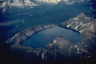 Kaguyak caldera was formed following powerful dacitic explosive eruptions about 5800 years ago. An extensive apron of pyroclastic-flow deposits surrounds the 2.5-km-wide caldera. This view from the SW shows two post-caldera lava domes that form a peninsula into the lake and another lava dome that forms a small island that rises about 10 m above the center of the lake. The low notch at the far end of the caldera is a pre-caldera stream valley that was beheaded by caldera formation.
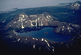 The small, but dramatic Kaguyak caldera on the northern Alaska Peninsula contains a lake more than 180-m deep whose surface is 550-m below the caldera rim. Two post-caldera lava domes form the large peak that rises above the rim of the 2.5-km-wide caldera at the right. The small island in the center of the lake is another lava dome. Collapse of the caldera occurred following powerful dacitic explosive eruptions about 5800 years ago. Shelikof Strait is visible at the top of the photo.
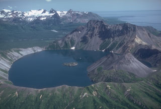 The small 2.5-km-wide Kaguyak caldera is filled by a lake that reaches 550 m below the caldera rim, seen here from the west. A lava dome extends into the lake on the SW side and another dome forms a small island in the center of the lake. The voluminous caldera-forming deposits have been radiocarbon dated at 5,800 years old. A large pre-caldera lava dome forms the high point on the eastern caldera rim. The broad valley of Big River descends to Shelikof Strait to the upper right.
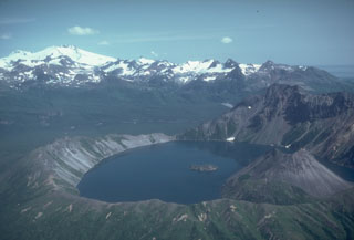 Fourpeaked volcano to the upper left is one of a group of volcanoes NE of Katmai National Park, beyond the 2.5-km-wide Kaguyak caldera in the foreground. Much of the surface is hidden beneath Fourpeaked Glacier; the few exposed outcrops are lava flows interlayered with volcanic agglomerate. Deposits near the summit are extensively hydrothermally altered.
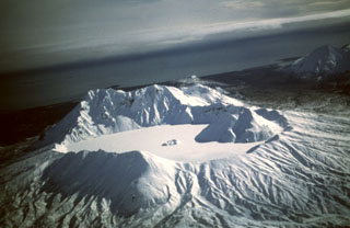 Snow and ice cover the Kaguyak caldera lake in this view from the NW. The caldera formed during a voluminous eruption about 5,800 years ago that produced pyroclastic flows that reached Shelikof Strait. Two lava domes, one large and the other seen just above the center of the lake, were built after the caldera-forming eruption.
The following 9 samples associated with this volcano can be found in the Smithsonian's NMNH Department of Mineral Sciences collections, and may be availble for research (contact the Rock and Ore Collections Manager). Catalog number links will open a window with more information.
| Catalog Number | Sample Description | Lava Source | Collection Date |
|---|---|---|---|
| NMNH 117233-65 | Tuff | -- | -- |
| NMNH 117233-66 | Pumice | -- | -- |
| NMNH 117233-67 | Dacite | -- | -- |
| NMNH 117233-68 | Tuff | -- | -- |
| NMNH 117233-69 | Tuff | -- | -- |
| NMNH 117233-70 | Pumice | -- | -- |
| NMNH 117233-71 | Pumice | -- | -- |
| NMNH 117233-72 | Pumice | -- | -- |
| NMNH 117233-73 | Pumice | -- | -- |
| Alaska Volcano Observatory (Link to Kaguyak) | The Alaska Volcano Observatory (AVO) is a joint program of the U.S. Geological Survey (USGS), the Geophysical Institute of the University of Alaska Fairbanks (UAFGI), and the State of Alaska Division of Geological and Geophysical Surveys (ADGGS). AVO was formed in 1988, and uses federal, state, and university resources to monitor and study Alaska's hazardous volcanoes, to predict and record eruptive activity, and to mitigate volcanic hazards to life and property. |
| Copernicus Browser | The Copernicus Browser replaced the Sentinel Hub Playground browser in 2023, to provide access to Earth observation archives from the Copernicus Data Space Ecosystem, the main distribution platform for data from the EU Copernicus missions. |
| MIROVA | Middle InfraRed Observation of Volcanic Activity (MIROVA) is a near real time volcanic hot-spot detection system based on the analysis of MODIS (Moderate Resolution Imaging Spectroradiometer) data. In particular, MIROVA uses the Middle InfraRed Radiation (MIR), measured over target volcanoes, in order to detect, locate and measure the heat radiation sourced from volcanic activity. |
| MODVOLC Thermal Alerts | Using infrared satellite Moderate Resolution Imaging Spectroradiometer (MODIS) data, scientists at the Hawai'i Institute of Geophysics and Planetology, University of Hawai'i, developed an automated system called MODVOLC to map thermal hot-spots in near real time. For each MODIS image, the algorithm automatically scans each 1 km pixel within it to check for high-temperature hot-spots. When one is found the date, time, location, and intensity are recorded. MODIS looks at every square km of the Earth every 48 hours, once during the day and once during the night, and the presence of two MODIS sensors in space allows at least four hot-spot observations every two days. Each day updated global maps are compiled to display the locations of all hot spots detected in the previous 24 hours. There is a drop-down list with volcano names which allow users to 'zoom-in' and examine the distribution of hot-spots at a variety of spatial scales. |
|
WOVOdat
Single Volcano View Temporal Evolution of Unrest Side by Side Volcanoes |
WOVOdat is a database of volcanic unrest; instrumentally and visually recorded changes in seismicity, ground deformation, gas emission, and other parameters from their normal baselines. It is sponsored by the World Organization of Volcano Observatories (WOVO) and presently hosted at the Earth Observatory of Singapore.
GVMID Data on Volcano Monitoring Infrastructure The Global Volcano Monitoring Infrastructure Database GVMID, is aimed at documenting and improving capabilities of volcano monitoring from the ground and space. GVMID should provide a snapshot and baseline view of the techniques and instrumentation that are in place at various volcanoes, which can be use by volcano observatories as reference to setup new monitoring system or improving networks at a specific volcano. These data will allow identification of what monitoring gaps exist, which can be then targeted by remote sensing infrastructure and future instrument deployments. |
| Volcanic Hazard Maps | The IAVCEI Commission on Volcanic Hazards and Risk has a Volcanic Hazard Maps database designed to serve as a resource for hazard mappers (or other interested parties) to explore how common issues in hazard map development have been addressed at different volcanoes, in different countries, for different hazards, and for different intended audiences. In addition to the comprehensive, searchable Volcanic Hazard Maps Database, this website contains information about diversity of volcanic hazard maps, illustrated using examples from the database. This site is for educational purposes related to volcanic hazard maps. Hazard maps found on this website should not be used for emergency purposes. For the most recent, official hazard map for a particular volcano, please seek out the proper institutional authorities on the matter. |
| IRIS seismic stations/networks | Incorporated Research Institutions for Seismology (IRIS) Data Services map showing the location of seismic stations from all available networks (permanent or temporary) within a radius of 0.18° (about 20 km at mid-latitudes) from the given location of Kaguyak. Users can customize a variety of filters and options in the left panel. Note that if there are no stations are known the map will default to show the entire world with a "No data matched request" error notice. |
| UNAVCO GPS/GNSS stations | Geodetic Data Services map from UNAVCO showing the location of GPS/GNSS stations from all available networks (permanent or temporary) within a radius of 20 km from the given location of Kaguyak. Users can customize the data search based on station or network names, location, and time window. Requires Adobe Flash Player. |
| DECADE Data | The DECADE portal, still in the developmental stage, serves as an example of the proposed interoperability between The Smithsonian Institution's Global Volcanism Program, the Mapping Gas Emissions (MaGa) Database, and the EarthChem Geochemical Portal. The Deep Earth Carbon Degassing (DECADE) initiative seeks to use new and established technologies to determine accurate global fluxes of volcanic CO2 to the atmosphere, but installing CO2 monitoring networks on 20 of the world's 150 most actively degassing volcanoes. The group uses related laboratory-based studies (direct gas sampling and analysis, melt inclusions) to provide new data for direct degassing of deep earth carbon to the atmosphere. |
| Large Eruptions of Kaguyak | Information about large Quaternary eruptions (VEI >= 4) is cataloged in the Large Magnitude Explosive Volcanic Eruptions (LaMEVE) database of the Volcano Global Risk Identification and Analysis Project (VOGRIPA). |
| EarthChem | EarthChem develops and maintains databases, software, and services that support the preservation, discovery, access and analysis of geochemical data, and facilitate their integration with the broad array of other available earth science parameters. EarthChem is operated by a joint team of disciplinary scientists, data scientists, data managers and information technology developers who are part of the NSF-funded data facility Integrated Earth Data Applications (IEDA). IEDA is a collaborative effort of EarthChem and the Marine Geoscience Data System (MGDS). |