Global Volcanism Program | Image GVP-05305

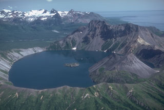
The small 2.5-km-wide Kaguyak caldera is filled by a lake that reaches 550 m below the caldera rim, seen here from the west. A lava dome extends into the lake on the SW side and another dome forms a small island in the center of the lake. The voluminous caldera-forming deposits have been radiocarbon dated at 5,800 years old. A large pre-caldera lava dome forms the high point on the eastern caldera rim. The broad valley of Big River descends to Shelikof Strait to the upper right.
Photo by Chris Nye, 1982 (Alaska Division of Geological and Geophysical Surveys, Alaska Volcano Observatory).
![]() This image is made available as a Public Domain Work, but proper attribution is appreciated.
This image is made available as a Public Domain Work, but proper attribution is appreciated.
Galleries: Lava Domes | Calderas
Keywords: caldera | lava dome | crater lake
Kaguyak