Fresh lava flows documented along ridge for over 15 km
Along the fast spreading East Pacific Rise (EPR) crest near 9°50'N, Cowen and others (2007) reported on additional evidence regarding recent volcanic eruptions spanning about 4-5 months of activity discovered in April and May 2006. In April 2006, during routine recovery and redeployment of ocean-bottom seismometers (OBS) at the EPR R2K Integrated Study Site (ISS) near 9°50'N, eight of 12 OBS could not be recovered (BGVN 31:11). Anomalous turbidity and temperature in the water column along the ridge axis confirmed scientists' suspicions that the OBS were trapped by a new lava flow. A resurgence in magmatism had been postulated recently, based on temporal changes observed over the past few years in hydrothermal vent fluid chemistry and temperatures (Von Damm, 2004) and increasing microseismicity (Tolstoy and others, 2006).
According to Cowen and others (2007), within a week of the initial bottom-water surveys in late April, scientists mounted a rapid response expedition on board the research vessel RV New Horizon. The expedition surveys included conductivity-temperature-depth (CTD) observations, optical tow-yos (tows during which a package is alternately lowered and raised), hydrocasts, and towed digital-imaging along the EPR axis between ~ 9°46'N and 9°57'N.
These surveys confirmed the occurrence of recent seafloor eruptions along more than 15 km of the ridge axis and up to ~ 1 km off axis. They documented widespread vigorous hydrothermal venting and a notable absence of vent megafauna (figure 6). Many of the hydrothermal vents studied over the past 15 years were disrupted. A prior eruption occurred in 1991-1992 (e.g., Haymon and others, 1993) along portions of the same segment of the EPR. This is the first repeat eruption documented at the same location along the mid-ocean ridge (MOR) crest.
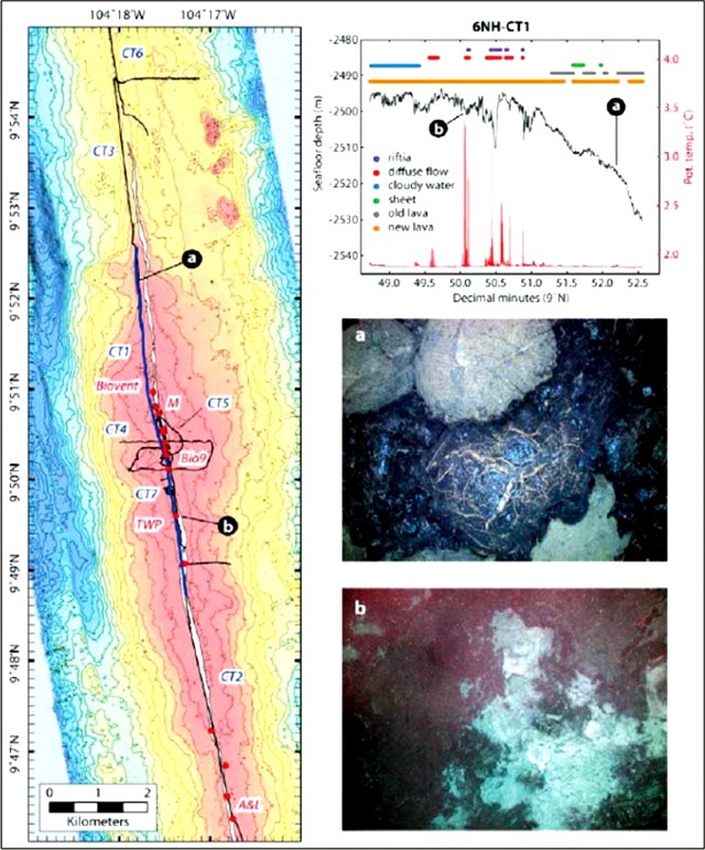 |
Figure 6. (Left) Location map of the track of the TowCam (Woods Hole Oceanographic Institution's digital deep-sea camera with rock and water sampling capabilities) which surveyed a distance of ~4 minutes of latitude (~7 km) along the ridge axis over the new eruptions. Red dots indicate old high-temperature hydrothermal vents. (Top right) An along-axis bathymetric profile of the EPR, ~7 km long, compiled from depth and altitude data from a TowCam. The profile is shown with geological and biological observations linked to symbols that appear in a key and on horizontal lines above the profile. The lowest trace, "new lava," is continuous over a broad expanse of the S end of the profile (on either side of "b" on the map), and areas without new lava appear at only a few spots near "a" (9°52'N). A plot of the potential temperature (the temperature of a water sample if lifted adiabatically, in effect, without thermal contact with surrounding water, to the surface) appears below the profile. TowCam photographs, keyed to their location along the track, include ("a" middle right) new pillow to lobate lava flow overlying older sediment-covered pillows and ("b" bottom right) diffuse hydrothermal venting through recently erupted lava, material possibly covered with microbial growth. Courtesy Cowen and others (2007). |
Toomey and others (2007) discussed how mantle upwelling is essential to the generation of new oceanic crust at mid-ocean ridges, and concluded that such upwelling is asymmetric beneath active ridges. In their article, the authors used seismic imaging to show that the isotropic and anisotropic structure of the mantle is rotated beneath the East Pacific Rise. The isotropic structure defines the pattern of magma delivery from the mantle to the crust. They found that the segmentation of the rise crest between transform faults correlates well with the distribution of mantle melt. The azimuth of seismic anisotropy constrains the direction of mantle flow, which is rotated nearly 10° anticlockwise from the plate-spreading direction. The mismatch between the locus of mantle melt delivery and the morphologic ridge axis results in systematic differences between areas of on-axis and off-axis melt supply. The authors conclude that the skew of asthenospheric upwelling and transport governs segmentation of the East Pacific Rise and variations in the intensity of ridge crest processes.
References. Cowen, J.P., Fornari, D.J., Shank, T.M., Love, B., Glazer, B., Treusch, A.H., Holmes, R.C., Soule, S.A., Baker, E.T., Tolstoy, M., and Pomraning, K.R., 2007 (13 February), Volcanic Eruptions at East Pacific Rise Near 9°50'N: Eos, Transactions, American Geophysical Union, v. 88, no. 7, p. 81, 83.
Haymon, R.M., Fornari, D.J., Edwards, M.H., Carbotte, S., Wright, D., and Macdonald, K.C., 1991, Hydrothermal vent distribution along the East Pacific Rise crest (9 deg 9'-54' N) and its relationship to magmatic and tectonic processes on fast-spreading mid-ocean ridges: Earth and Planetary Science Letters, v. 104, p. 513-534.
Haymon, R.M., Fornari, D.J., Von Damm, K.L., Lilley, M.D., Perfit, M.R., Edmond, J.M., Shanks, W.C., III, Lutz, R.A., Grebmeir, J.M., Carbotte, S., Wright, D., McLaughlin, E., Smith, M. Beedle, N., and Olson, E., 1993, Volcanic eruption of the mid-ocean ridge along the East Pacific Rise crest at 9 deg 45-52 min N: direct submersible observations of seafloor phenomena associated with an eruption event in April 1991: Earth and Planetary Science Letters, v. 119, p. 85-101
Toomey, D.R., Jousselin, D., Dunn, R.A., Wilcock, W.S., and Detrick, R.S., 2007, Skew of mantle upwelling beneath the East Pacific Rise governs segmentation: Nature, v. 446, p. 409-414 (doi:10.1038/nature05679).
Tolstoy, M., J.P. Cowen, E.T. Baker, D.J. Fornari, K.H. Rubin, T.M. Shank, F. Waldhauser, D.R. Bohnenstiehl, D.W. Forsyth, R.C. Holmes, B. Love, M.R. Perfit, R.T. Weekly, S.A. Soule, and B. Glazer, 2006, A sea-floor spreading event captured by seismometers: Science, v. 314, no. 5807, p. 1920-1922.
Von Damm, K. L., 2004, Evolution of the hydrothermal system at East Pacific Rise 9°50'N: Geochemical evidence for changes in the upper oceanic crust, in C. German and others (ed), Mid-Ocean Ridges: Hydrothermal Interactions Between the Lithosphere and Ocean: Geophys. Monogr. Ser., v. 148, p. 285-304.
Information Contacts: RV New Horizon and Scripps Institution of Oceanography, University of California - San Diego, 8602 La Jolla Shores Drive, La Jolla, CA 92037, USA (URL: http://sio.ucsd.edu/); Woods Hole Oceanographic Institution, Woods Hole, MA 02543, USA (URL: http://www.whoi.edu/).
The Global Volcanism Program has no Weekly Reports available for Northern EPR at 9.8°N.
Reports are organized chronologically and indexed below by Month/Year (Publication Volume:Number), and include a one-line summary. Click on the index link or scroll down to read the reports.
Post-1989 lava flows and high turbidity seen from submersible; frequent microseismicity
Evidence for a recent, possibly ongoing eruption on the axis of the East Pacific Rise was found between 31 March and 24 April during a series of 25 Adventure Program Alvin dives (led by Rachel Haymon and Dan Fornari). The following phenomena suggested eruptive activity:
1. Bottom waters were extremely murky. A high density of suspended particulate matter plus white biogenic particles swept from the bottom by strong hydrothermal flow created a turbid zone to 50 m above the sea floor.
2. Total flux of hydrothermal fluid over the area was very high and temperatures reached 403°C.
3. Animal communities documented by an ARGO survey in November-December 1989 (Haymon and others, 1991) had been buried by fresh lava flows, and the scorched soft tissues of partially buried biota had not yet attracted crabs and other bottom scavengers.
4. At one vent, temperature increased from 389 to 403°C and fluid composition changed during a two-week period.
5. Fresh, sulfate-bearing chimneys at the collapsed margin of the axial summit caldera were draped with new flows. At sites of black smoker chimneys seen from ARGO, [hydrothermal fluids or black smoke] poured directly from piles of collapse rubble.
6. At a number of sites, high-temperature fluids vented directly from the basaltic sea floor, probably because there had been insufficient time for chimneys to form.
7. Vent animal communities were absent (presumably had not yet developed) at many sites where H2S-rich effluents were sampled. Instead, basalts near the vents were extensively coated with unusual white bacterial mats, not seen during the 1989 survey, that appear different from those previously described at other sea-floor hot springs.
After a seismically detected eruption of the submarine volcano Kick-'em-Jenny (N of Grenada, West Indies) in December 1988, observations from a submersible in mid-April 1989 revealed bacterial mats at the eruption site, associated with upwelling hydrothermal fluid and an apparently anoxic environment. The mats were breaking up by the next dive in mid-May, and normal sea life was returning.
In mid-May, ocean bottom seismographs, deployed from the RV Thomas Washington to monitor the volcanic activity, detected frequent microseismicity. Of the seven instruments deployed (at 5-km spacing), five returned usable data, and two (on-axis at 9.808°N, 104.286°W, off-axis at 9.816°N, 104.243°W) were examined in detail. A total of 151 local events were recorded in 68 hours (figure 1). The data suggested swarm-like behavior, although the time series was too short to reveal a well-defined pattern. Time intervals between P, S, and interface waves indicated that the majority of events were at distances of 0.5-2 km. Many of the events recorded strongly on-axis were detected poorly if at all by the off-axis instrument; the best-recorded phases off-axis were often the water waves. Seismologists noted that these observations suggest that seismicity was centered near the ridge axis and was probably very shallow (0.5-2 km depth), since events at the depth of the instrument spacing (5 km) would be roughly equidistant from the two stations. It seemed likely that at least 10 km of the ridge axis was generating microseismicity.
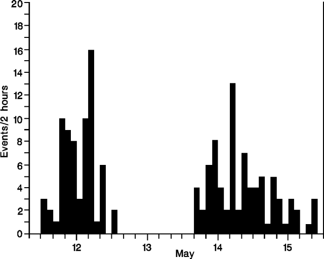 |
Figure 1. Number of seismic events detected in 2-hour periods by ocean bottom seismometers along the East Pacific Rise near 9.8°N, 12-15 May, 1991. The 24-hour gap in data represents airgun recording for local crustal structure inversion. Courtesy of J. Hildebrand. |
Currently funded programs that will visit the site include: 1-2 dives by Nautile in October 1991 (D. Desbruyeres, CNEXO, Brest); Alvin dives in November-December 1991 (L. Mullineaux and C. van Dover, Woods Hole Oceanographic Institution), January 1992 (R. Haymon, Univ of California at Santa Barbara and R. Lutz, Rutgers), and April 1992 (J. Childress, UCSB). Ocean Drilling Program leg 142 will begin efforts to drill the ridge axis in late January 1992 (R. Batiza, Univ of Hawaii). A special session on studies at 9-10°N will be held at the fall 1991 American Geophysical Union meeting.
Reference. Haymon, R., Fornari, D., Edwards, M., Carbotte, S., Wright, D., and Macdonald, K.C., Hydrothermal vent distribution along the East Pacific Rise crest (9°9'-54'N) and its relationship to magmatic and tectonic processes on fast-spreading mid-ocean ridges: Earth and Planetary Science Letters, v. 104, p. 513-534.
Information Contacts: R. Haymon, Univ of California, Santa Barbara; J. Hildebrand, S. Webb, and L. Dohrman, Scripps Inst of Oceanography; T. Stroh, RIDGE, Univ of Washington.
New submarine lava flows off Central America
Scientists verified a recent seafloor eruption at 9°50'N on the E Pacific Rise (EPR) between ~104°16'00"W and 104°18'58"W (figure 2). This area was visited during cruises of the Research Vessel RV Knorr, 24-26 April 2006, and of the RV New Horizon, 10-17 May 2006. In early April 2006 some ocean bottom seismometers deployed in the area failed to return to the ocean surface when instructed. As a result, scientists suspected that a seafloor eruption may have buried the seismometers with lava (Venture Deep Ocean website).
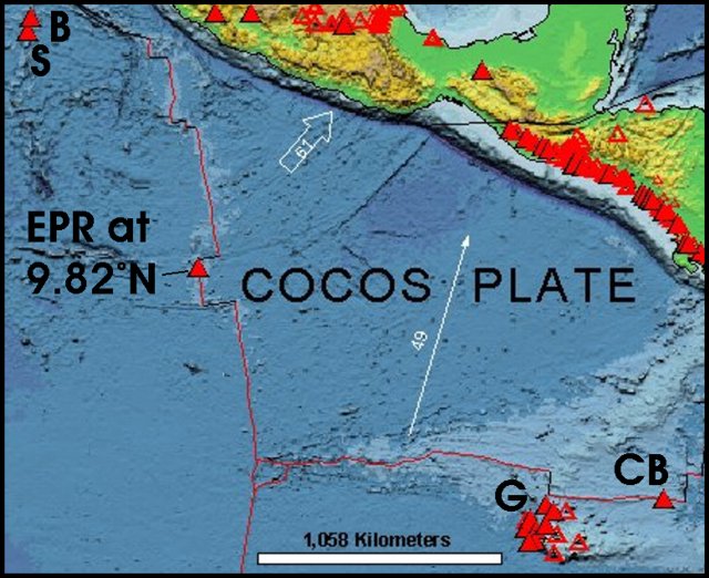 |
Figure 2. Map showing the EPR off Central America. Solid triangles show Holocene volcanoes, and the sub-vertical (N-S) line shows the axis of the EPR (with this volcano at 9.82°E labeled). The Galapagos islands (G) lie in the cluster of known volcanoes there. The Clam Bake (CB) vent zone sits farther E along the Galapagos ridge. The Revillagigedo Islands (Barcena and Socorro) appear at upper left (B and S). Courtesy of the This Dynamic Planet website (Simkin and others, 2006). |
The RV Knorr recovered samples of new seafloor by dredging along the EPR axis in response to this possible eruption. The first seafloor images, collected several weeks later in May 2006 by RV New Horizon, showed fresh and older lavas interspersed along the dredge track (figures 3 and 4). The images also documented young lavas spanning nearly 13 km (between 9°47' and 9°54' N), an area known to cover a significant range in neovolcanic lava compositions.
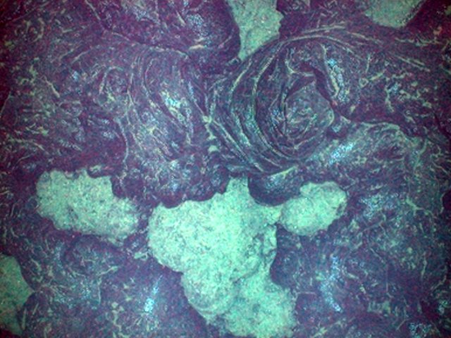 |
Figure 3. Towed-camera view along the crest of the EPR from the New Horizon, 11 May 2006, of a newly erupted (2006?) glassy lobate lava flow overlying older lava. Based on comparisons with images from the submersible Alvin in March 1992, it appeared to be a recent eruption. Cruise scientists tentatively suggested, based on the character of the lava surfaces compared with the underlying lava, that the eruption may have occurred 1 to 6 months earlier. Cast 2, TowCam Run 1, 9°50.2'N, 104°17.5'W, seafloor depth 2,498 m. Courtesy of the Ridge 2000 Program. |
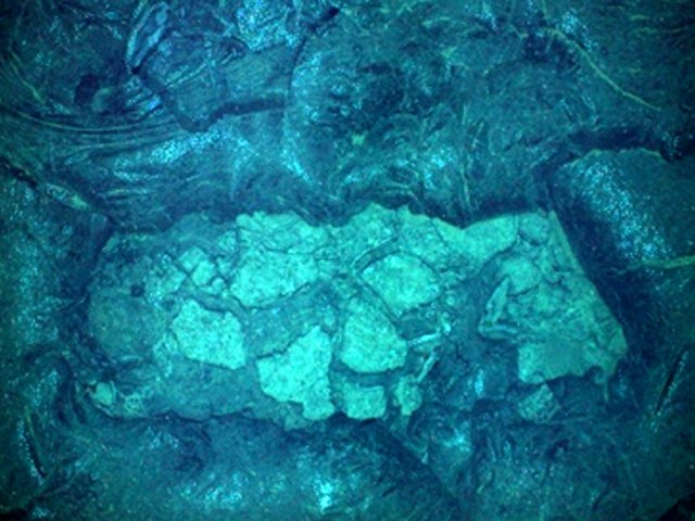 |
Figure 4. Towed-camera view on the EPR from the New Horizon, 11 May 2006, showing a new lava flow framing an exposure of lava that appeared older. The latter (center of frame) was lighter-colored and lobate. Preliminary analysis of the photos suggested that a new lava flow was present at 9°47' N, but perhaps not farther S. In many places (on this and TowCam Run 1) the new flow appeared less than 1 m thick. Cast 4, TowCam Run 2, ~ 9°47' N, ~ 104°17' W, seafloor depth ~ 2,500 m. Courtesy of the Ridge 2000 Program. |
Tolstoy (2006) discussed heightened seismicity detected by ocean-bottom instruments along this part of the EPR. The most pronounced seismicity occurred in the time period of late January 2006. In addition, the U.S. Geological Survey's Earthquake Hazards Program reported an M 5.4 earthquake on the EPR at 2345 UTC on 30 July 2006. It was at 10.06°N, 104.21°W and at a depth of 10 km. Another nearby EPR earthquake, also M 5.4, struck at 0124 UTC on 31 July, centered at 10.01°N, 103.89°W and a depth of ~10 km. Both epicenters were within several kilometers of the eruption site.
Ken Rubin and Mike Perfit suggested (Rubin and Perfit, 2006) that the new eruption (Bowles and others, 2006) provided an opportunity to define the temporal-spatial evolution of new volcanic seafloor. Such an analysis would provide information not only on how the eruption progressed, but would also form a baseline to subsequent biological, geochemical, and geological observations. According to Rubin and Perfit, sample collection and subsequent radiochemical analysis must be conducted within 1-2 months of the eruptive event because of the 210Po-210Pb radiometric dating method they employ, with a 210Po half-life 138 days. Generation of a detailed surface-age map (with resolution of 2-3 weeks) would require multiple, small, geographically dispersed samples (tens of grams) with known geological context, collected and analyzed within several months after an eruption. Such sampling would be best conducted from a submersible. This dating scheme is not possible more than ~1.5 years after the eruption.
References. Bowles J, Gee, J.S., Kent, D.V., Perfit, M.R., Soule, S.A., and Fornari, D.J., 2006, Paleointensity applications to timing and extent of eruptive activity, 9°-10°N East Pacific Rise: Geochemistry Geophysics Geosystems 7, Q06006, doi:10.1029/2005GC001141.
Haymon, R.M., Fornari, D.J., Edwards, M.H., Carbotte, S., Wright, D., and Macdonald, K.C., 1991, Hydrothermal vent distribution along the E Pacific Rise crest (9°9'-54'N) and its relationship to magmatic and tectonic processes on fast-spreading mid-ocean ridges: Earth and Planetary Science Letters, v. 104, p. 513-534.
Haymon, R.M., Fornari, D.J., Von Damm, K.L., Lilley, M.D., Perfit, M.R., Edmond, J.M., Shanks, W.C., Lutz, R.A., Grebmeier, J.B., Carbotte, S., Wright, D.J., McLaughlin, E., Smith, E., Beedle, N., and Olson, E., 1993, Volcanic eruption of the mid-ocean ridge along the E Pacific Rise crest at 9 degrees 45-52'N; direct submersible observations of seafloor phenomena associated with an eruption event in April, 1991: Earth and Planetary Sciences Letter, v. 119, p. 85-101.
Rubin, K.H, and Perfit, M.R., 2006, High resolution lava surface dating and mapping at 9°50'N EPR: How and Why: Ridge 200 Program, 13 May 2006 discussion paper linked from http://www.ridge2000.org/science/discussion/?m=200604.
Rubin, K.H., Macdougall, J.D., and Perfit, M.R., 1994, 210Po-210Pb dating of recent volcanic eruptions on the seafloor: Nature, v. 368, p. 841-844.
Simkin, T., Tilling, R.I., Vogt, P.R., Kirby, S.H., Kimberly, P., and Stewart, D.B., 2006, This dynamic planet: World map of volcanoes, earthquakes, impact craters, and plate tectonics: U.S. Geological Survey Geologic Investigations Series Map I-2800, 1 two-sided sheet, scale 1:30,000,000.
Smith, M., Perfit, M.R., Fornari, D.J., Ridley, W., Edwards, M.H., Kurras, G., and Von Damm, K.L., 2001, Magmatic processes and segmentation at a fast spreading mid-ocean ridge: detailed investigation of an axial discontinuity on the E Pacific Rise crest at 9°37'N: Geochemistry Geophysics Geosystems, v. 2, no. 10, doi:10.1029/2000GC000134.Tolstoy, M., 22 May 2006, First look at seismic data from EPR 9° 50' N Ocean Bottom Seismometers: Results from Knorr OBS turn-around: Ridge 2000 Program (http://www.ridge2000.org/science/tcs/epr06activity.html).
Information Contacts: Kenneth H. Rubin, School of Ocean and Earth Science and Technology, University of Hawai'i at Manoa, 1680 East-West Road, Honolulu, HI 96822, USA; Michael R. Perfit, Dept of Geological Sciences, Univ of Florida, 365 Williamson Hall, Gainesville, FL 32606, USA; Ridge 2000 Program, EPR 9N Integrated Studies Site (ISS) Latest Updates, 22 May 2006; Venture Deep Ocean, website by the Education & Outreach team of Ridge 2000 Program Office, Scripps Institution of Oceanography, University of California, San Diego, 9500 Gilman Drive, La Jolla, CA 92093-0225, USA; U.S. Geological Survey Earthquake Hazards Program (URL: http://earthquake.usgs.gov/).
Lava erupted along at least 18 km of ridge axis
According to the RIDGE 2000 Program website, a new eruption on the East Pacific rise (EPR) was first suspected during a visit to the site by the research vessel RV Knorr in April 2006. Since October 2003 an array of up to 12 ocean-bottom seismometers (OBSs) had been deployed in an area ~ 4 x 4 km located between 9°49' N and 9°51' N (the EPR Integrated Study Site, ISS) as part of a continuing microseismicity monitoring project being led by Maya Tolstoy and Felix Waldhauser.
Investigators attempted to recover 12 OBSs on 25 April 2006, but only four were recovered. Tolstoy and others (2006), Chadwick (2006), and the Ridge 2000 Program (2006) reported that eight OBS were stuck in the new lava on the sea floor (see figure 5) from an eruption that had occurred since the last OBS servicing in May 2005. Water column measurements were also made by the RV Knorr, yielding light-scattering measurements indicative of extensive particulates in the water column, and corroborating the evidence for a recent eruption (BGVN 31:06).
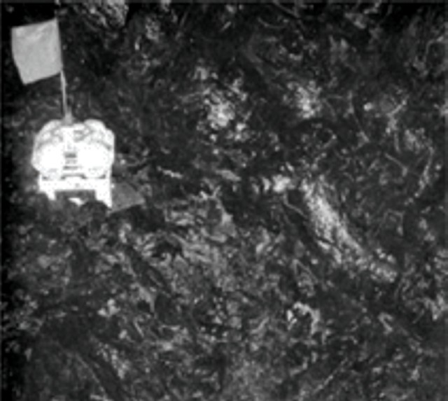 |
Figure 5. Sea floor photo from the TowCam taken on the EPR during the June 2006 RV Atlantis cruise showing an ocean-bottom seismometer caught in a new lava flow. Taken from Chadwick (2006). |
The TowCam images suggested that the new lavas erupted from fissures within the axial summit trough (AST), which reestablished quickly after the event by drain-back and collapse. Comparison of TowCam bathymetry with pre-eruption Alvin mapping suggested that after the eruption the axial summit trough became 10-15 m narrower and a few meters shallower at 9°50.4' N. Lava flow morphologies indicate that the highest effusion rates were near 9°50' N.
Radiometric dating of 10 rocks collected from the young terrain is under way, using 210Po. Preliminary 210Po results in Tolstoy and others (2006) indicate that nine of the rocks were erupted within a year before their collection, with dates ranging from late summer 2005 to January 2006.
According to Tolstoy and others (2006), based on the sea-floor images, the extent of water column anomalies, the preliminary lava ages, and the distribution of OBSs that failed to return, they estimated that the flow extended intermittently for at least 18 km along the ridge axis. This zone extends from 9°46' N to 9°55.7' N, with off-axis extent ranging from 0 to 1 km. The eruption occurred on the same segment (segment B) as the 1991-1992 eruption, with a similar length scale.
The loss of some seismometers did not preclude the capture of important data associated with the eruption, including precursory activity. Tolstoy and others (2006) found a gradual ramp-up in seismicity since monitoring began at this site in October 2003. The pattern of seismicity culminated in an intense but brief (6-hour) inferred diking event on 22 January 2006, followed by rapid tapering to markedly decreased levels of seismicity.
Two follow-up cruises proceeded to the eruption site, the RV New Horizon in April-May 2006, and the RV Atlantis in June 2006. They assessed the extent of the new eruption and its effect on the biological communities, ecosystems, and chemistry at the EPR ISS. More work on the event was recently reported at the Fall 2006 meeting of the American Geophysical Union (Eg., session V13 C).
Background. The East Pacific Rise (EPR) near 9°50' N spreads at a full rate of ~ 110 mm per year and is one of the better-studied mid-ocean ridge (MOR) segments in the world. Ever since an eruption was documented in 1991, scientists have regularly returned to document ecosystem progression, to study changes in vent-fluid chemistry and temperature, and to conduct detailed geological mapping. Anomalies in water-column measurements of temperature and light scattering indicated vigorous discharge of high-temperature hydrothermal fluids. Radiometric dating of rocks collected from the young terrain, using 210Po, indicated that many of the rocks were erupted within a year before their collection. Sea-floor images give further evidence of the recency of surface lava flows.
References. Tolstoy, M., Cowen, J.P., Baker, E.T., Fornari, D.J., Rubin, K.H., Shank, T.M., Waldhauser, F., Bohnenstiehl, D.R., Forsyth, D.W., Holmes, R.C., Love, B., Perfit, M.R., Weekly, R.T., Soule, S.A., and Glazer, B., 2006, A sea-floor spreading event captured by seismometers, Science, v. 314, no. 5807, p. 1920-1922.
Hinds, J.S., Perfit, M.R., Soule, S.A., Fornari, D.J., and Ridley, W.I., 2005, Discriminating lava flows from the EPR ISS (9°25'-9°55' N) using lava morphology, petrography, and geochemistry: American Geophysical Union, Fall Meeting 2005, abstract ##T31A-0496 (2005AGUFM.T31A0496H).
Chadwick, W.W., Jr., 2006, A submarine volcano is caught in the act: Science, v. 314, no. 5807, p. 1887-1888.
Ridge 2000 Program, 2006, News: Ridge 2000 research discover/document seafloor eruption: Ridge 2000 Program web site, URL: http://www.ridge2000.org/science/tcs/epr_2006_science_supp_material.php.
Information Contacts: Ridge 2000 Program, Ridge 2000 Program Office, Institute of Geophysics and Planetology (IGPP), University of California San Diego, Scripps Institution of Oceanography, La Jolla, CA 92093-0225, USA (URL: http://www.ridge2000.org/).
Fresh lava flows documented along ridge for over 15 km
Along the fast spreading East Pacific Rise (EPR) crest near 9°50'N, Cowen and others (2007) reported on additional evidence regarding recent volcanic eruptions spanning about 4-5 months of activity discovered in April and May 2006. In April 2006, during routine recovery and redeployment of ocean-bottom seismometers (OBS) at the EPR R2K Integrated Study Site (ISS) near 9°50'N, eight of 12 OBS could not be recovered (BGVN 31:11). Anomalous turbidity and temperature in the water column along the ridge axis confirmed scientists' suspicions that the OBS were trapped by a new lava flow. A resurgence in magmatism had been postulated recently, based on temporal changes observed over the past few years in hydrothermal vent fluid chemistry and temperatures (Von Damm, 2004) and increasing microseismicity (Tolstoy and others, 2006).
According to Cowen and others (2007), within a week of the initial bottom-water surveys in late April, scientists mounted a rapid response expedition on board the research vessel RV New Horizon. The expedition surveys included conductivity-temperature-depth (CTD) observations, optical tow-yos (tows during which a package is alternately lowered and raised), hydrocasts, and towed digital-imaging along the EPR axis between ~ 9°46'N and 9°57'N.
These surveys confirmed the occurrence of recent seafloor eruptions along more than 15 km of the ridge axis and up to ~ 1 km off axis. They documented widespread vigorous hydrothermal venting and a notable absence of vent megafauna (figure 6). Many of the hydrothermal vents studied over the past 15 years were disrupted. A prior eruption occurred in 1991-1992 (e.g., Haymon and others, 1993) along portions of the same segment of the EPR. This is the first repeat eruption documented at the same location along the mid-ocean ridge (MOR) crest.
|
Figure 6. (Left) Location map of the track of the TowCam (Woods Hole Oceanographic Institution's digital deep-sea camera with rock and water sampling capabilities) which surveyed a distance of ~4 minutes of latitude (~7 km) along the ridge axis over the new eruptions. Red dots indicate old high-temperature hydrothermal vents. (Top right) An along-axis bathymetric profile of the EPR, ~7 km long, compiled from depth and altitude data from a TowCam. The profile is shown with geological and biological observations linked to symbols that appear in a key and on horizontal lines above the profile. The lowest trace, "new lava," is continuous over a broad expanse of the S end of the profile (on either side of "b" on the map), and areas without new lava appear at only a few spots near "a" (9°52'N). A plot of the potential temperature (the temperature of a water sample if lifted adiabatically, in effect, without thermal contact with surrounding water, to the surface) appears below the profile. TowCam photographs, keyed to their location along the track, include ("a" middle right) new pillow to lobate lava flow overlying older sediment-covered pillows and ("b" bottom right) diffuse hydrothermal venting through recently erupted lava, material possibly covered with microbial growth. Courtesy Cowen and others (2007). |
Toomey and others (2007) discussed how mantle upwelling is essential to the generation of new oceanic crust at mid-ocean ridges, and concluded that such upwelling is asymmetric beneath active ridges. In their article, the authors used seismic imaging to show that the isotropic and anisotropic structure of the mantle is rotated beneath the East Pacific Rise. The isotropic structure defines the pattern of magma delivery from the mantle to the crust. They found that the segmentation of the rise crest between transform faults correlates well with the distribution of mantle melt. The azimuth of seismic anisotropy constrains the direction of mantle flow, which is rotated nearly 10° anticlockwise from the plate-spreading direction. The mismatch between the locus of mantle melt delivery and the morphologic ridge axis results in systematic differences between areas of on-axis and off-axis melt supply. The authors conclude that the skew of asthenospheric upwelling and transport governs segmentation of the East Pacific Rise and variations in the intensity of ridge crest processes.
References. Cowen, J.P., Fornari, D.J., Shank, T.M., Love, B., Glazer, B., Treusch, A.H., Holmes, R.C., Soule, S.A., Baker, E.T., Tolstoy, M., and Pomraning, K.R., 2007 (13 February), Volcanic Eruptions at East Pacific Rise Near 9°50'N: Eos, Transactions, American Geophysical Union, v. 88, no. 7, p. 81, 83.
Haymon, R.M., Fornari, D.J., Edwards, M.H., Carbotte, S., Wright, D., and Macdonald, K.C., 1991, Hydrothermal vent distribution along the East Pacific Rise crest (9 deg 9'-54' N) and its relationship to magmatic and tectonic processes on fast-spreading mid-ocean ridges: Earth and Planetary Science Letters, v. 104, p. 513-534.
Haymon, R.M., Fornari, D.J., Von Damm, K.L., Lilley, M.D., Perfit, M.R., Edmond, J.M., Shanks, W.C., III, Lutz, R.A., Grebmeir, J.M., Carbotte, S., Wright, D., McLaughlin, E., Smith, M. Beedle, N., and Olson, E., 1993, Volcanic eruption of the mid-ocean ridge along the East Pacific Rise crest at 9 deg 45-52 min N: direct submersible observations of seafloor phenomena associated with an eruption event in April 1991: Earth and Planetary Science Letters, v. 119, p. 85-101
Toomey, D.R., Jousselin, D., Dunn, R.A., Wilcock, W.S., and Detrick, R.S., 2007, Skew of mantle upwelling beneath the East Pacific Rise governs segmentation: Nature, v. 446, p. 409-414 (doi:10.1038/nature05679).
Tolstoy, M., J.P. Cowen, E.T. Baker, D.J. Fornari, K.H. Rubin, T.M. Shank, F. Waldhauser, D.R. Bohnenstiehl, D.W. Forsyth, R.C. Holmes, B. Love, M.R. Perfit, R.T. Weekly, S.A. Soule, and B. Glazer, 2006, A sea-floor spreading event captured by seismometers: Science, v. 314, no. 5807, p. 1920-1922.
Von Damm, K. L., 2004, Evolution of the hydrothermal system at East Pacific Rise 9°50'N: Geochemical evidence for changes in the upper oceanic crust, in C. German and others (ed), Mid-Ocean Ridges: Hydrothermal Interactions Between the Lithosphere and Ocean: Geophys. Monogr. Ser., v. 148, p. 285-304.
Information Contacts: RV New Horizon and Scripps Institution of Oceanography, University of California - San Diego, 8602 La Jolla Shores Drive, La Jolla, CA 92037, USA (URL: http://sio.ucsd.edu/); Woods Hole Oceanographic Institution, Woods Hole, MA 02543, USA (URL: http://www.whoi.edu/).
This compilation of synonyms and subsidiary features may not be comprehensive. Features are organized into four major categories: Cones, Craters, Domes, and Thermal Features. Synonyms of features appear indented below the primary name. In some cases additional feature type, elevation, or location details are provided.
Thermal |
||||
| Feature Name | Feature Type | Elevation | Latitude | Longitude |
| Venture Hydrothermal Fields | Thermal | |||
|
|
||||||||||||||||||||||||||
There is data available for 17 confirmed Holocene eruptive periods.
2005 Aug 16 (?) ± 15 days - 2006 Jan 16 (?) ± 15 days Confirmed Eruption VEI: 0
| Episode 1 | Eruption | East Pacific Rise (9.8 deg N) | |||||||||||||||||||||||||||||
|---|---|---|---|---|---|---|---|---|---|---|---|---|---|---|---|---|---|---|---|---|---|---|---|---|---|---|---|---|---|---|
| 2005 Aug 16 (?) ± 15 days - 2006 Jan 16 (?) ± 15 days | Evidence from Observations: Reported | |||||||||||||||||||||||||||||
|
List of 4 Events for Episode 1 at East Pacific Rise (9.8 deg N)
| ||||||||||||||||||||||||||||||
1991 Dec 1 ± 30 days - 1992 Feb 4 ± 30 days Confirmed Eruption VEI: 0
| Episode 1 | Eruption | East Pacific Rise (9.9 deg N) | |||||||||||||||||||
|---|---|---|---|---|---|---|---|---|---|---|---|---|---|---|---|---|---|---|---|---|
| 1991 Dec 1 ± 30 days - 1992 Feb 4 ± 30 days | Evidence from Observations: Reported | |||||||||||||||||||
|
List of 2 Events for Episode 1 at East Pacific Rise (9.9 deg N)
| ||||||||||||||||||||
1991 Mar 16 (?) ± 15 days Confirmed Eruption VEI: 0
| Episode 1 | Eruption | East Pacific Rise (9.8 deg N) | |||||||||||||||||||
|---|---|---|---|---|---|---|---|---|---|---|---|---|---|---|---|---|---|---|---|---|
| 1991 Mar 16 (?) ± 15 days - Unknown | Evidence from Observations: Reported | |||||||||||||||||||
|
List of 2 Events for Episode 1 at East Pacific Rise (9.8 deg N)
| ||||||||||||||||||||
1988 Jul 2 ± 1 years ± 182 days Confirmed Eruption VEI: 0
| Episode 1 | Eruption | East Pacific Rise (9.3 deg N) | |||||||||||||||||||
|---|---|---|---|---|---|---|---|---|---|---|---|---|---|---|---|---|---|---|---|---|
| 1988 Jul 2 ± 1 years ± 182 days - Unknown | Evidence from Observations: Reported | |||||||||||||||||||
|
List of 2 Events for Episode 1 at East Pacific Rise (9.3 deg N)
| ||||||||||||||||||||
1950 Jul 2 (?) ± 182 days Confirmed Eruption VEI: 0
| Episode 1 | Eruption | East Pacific Rise (9.9 deg N) | ||||||||||||||||||||||||
|---|---|---|---|---|---|---|---|---|---|---|---|---|---|---|---|---|---|---|---|---|---|---|---|---|---|
| 1950 Jul 2 (?) ± 182 days - Unknown | Evidence from Correlation: Magnetism | ||||||||||||||||||||||||
|
List of 3 Events for Episode 1 at East Pacific Rise (9.9 deg N)
| |||||||||||||||||||||||||
1875 (in or before) Confirmed Eruption VEI: 0
| Episode 1 | Eruption | East Pacific Rise (9.9 deg N) | |||||||||||||||||||
|---|---|---|---|---|---|---|---|---|---|---|---|---|---|---|---|---|---|---|---|---|
| 1875 (in or before) - Unknown | Evidence from Correlation: Magnetism | |||||||||||||||||||
|
List of 2 Events for Episode 1 at East Pacific Rise (9.9 deg N)
| ||||||||||||||||||||
1650 ± 100 years Confirmed Eruption VEI: 0
| Episode 1 | Eruption | East Pacific Rise (9.8 deg N) | |||||||||||||||||||
|---|---|---|---|---|---|---|---|---|---|---|---|---|---|---|---|---|---|---|---|---|
| 1650 ± 100 years - Unknown | Evidence from Isotopic: Uranium-series | |||||||||||||||||||
|
List of 2 Events for Episode 1 at East Pacific Rise (9.8 deg N)
| ||||||||||||||||||||
1600 ± 150 years Confirmed Eruption VEI: 0
| Episode 1 | Eruption | East Pacific Rise (9.9 deg N) | |||||||||||||||||||
|---|---|---|---|---|---|---|---|---|---|---|---|---|---|---|---|---|---|---|---|---|
| 1600 ± 150 years - Unknown | Evidence from Isotopic: Uranium-series | |||||||||||||||||||
|
List of 2 Events for Episode 1 at East Pacific Rise (9.9 deg N)
| ||||||||||||||||||||
1200 ± 300 years Confirmed Eruption VEI: 0
| Episode 1 | Eruption | East Pacific Rise (9.8 deg N) | |||||||||||||||||||
|---|---|---|---|---|---|---|---|---|---|---|---|---|---|---|---|---|---|---|---|---|
| 1200 ± 300 years - Unknown | Evidence from Isotopic: Uranium-series | |||||||||||||||||||
|
List of 2 Events for Episode 1 at East Pacific Rise (9.8 deg N)
| ||||||||||||||||||||
0950 ± 2000 years Confirmed Eruption VEI: 0
| Episode 1 | Eruption | East Pacific Rise (9.5 deg N) | |||||||||||||||||||
|---|---|---|---|---|---|---|---|---|---|---|---|---|---|---|---|---|---|---|---|---|
| 0950 ± 2000 years - Unknown | Evidence from Isotopic: Uranium-series | |||||||||||||||||||
|
List of 2 Events for Episode 1 at East Pacific Rise (9.5 deg N)
| ||||||||||||||||||||
0850 ± 200 years Confirmed Eruption VEI: 0
| Episode 1 | Eruption | East Pacific Rise (9.9 deg N) | |||||||||||||||||||
|---|---|---|---|---|---|---|---|---|---|---|---|---|---|---|---|---|---|---|---|---|
| 0850 ± 200 years - Unknown | Evidence from Isotopic: Uranium-series | |||||||||||||||||||
|
List of 2 Events for Episode 1 at East Pacific Rise (9.9 deg N)
| ||||||||||||||||||||
0050 BCE ± 2000 years Confirmed Eruption VEI: 0
| Episode 1 | Eruption | East Pacific Rise (9.5 deg N) | |||||||||||||||||||
|---|---|---|---|---|---|---|---|---|---|---|---|---|---|---|---|---|---|---|---|---|
| 0050 BCE ± 2000 years - Unknown | Evidence from Isotopic: Uranium-series | |||||||||||||||||||
|
List of 2 Events for Episode 1 at East Pacific Rise (9.5 deg N)
| ||||||||||||||||||||
1050 BCE ± 2000 years Confirmed Eruption VEI: 0
| Episode 1 | Eruption | East Pacific Rise (9.5 deg N) | |||||||||||||||||||
|---|---|---|---|---|---|---|---|---|---|---|---|---|---|---|---|---|---|---|---|---|
| 1050 BCE ± 2000 years - Unknown | Evidence from Isotopic: Uranium-series | |||||||||||||||||||
|
List of 2 Events for Episode 1 at East Pacific Rise (9.5 deg N)
| ||||||||||||||||||||
2050 BCE ± 2000 years Confirmed Eruption VEI: 0
| Episode 1 | Eruption | East Pacific Rise (9.5 deg N) | |||||||||||||||||||
|---|---|---|---|---|---|---|---|---|---|---|---|---|---|---|---|---|---|---|---|---|
| 2050 BCE ± 2000 years - Unknown | Evidence from Isotopic: Uranium-series | |||||||||||||||||||
|
List of 2 Events for Episode 1 at East Pacific Rise (9.5 deg N)
| ||||||||||||||||||||
3050 BCE ± 2000 years Confirmed Eruption VEI: 0
| Episode 1 | Eruption | EPR axis and East of axis | |||||||||||||||||||
|---|---|---|---|---|---|---|---|---|---|---|---|---|---|---|---|---|---|---|---|---|
| 3050 BCE ± 2000 years - Unknown | Evidence from Isotopic: Uranium-series | |||||||||||||||||||
|
List of 2 Events for Episode 1 at EPR axis and East of axis
| ||||||||||||||||||||
4050 BCE ± 2000 years Confirmed Eruption VEI: 0
| Episode 1 | Eruption | East Pacific Rise (9.5 deg N) | |||||||||||||||||||
|---|---|---|---|---|---|---|---|---|---|---|---|---|---|---|---|---|---|---|---|---|
| 4050 BCE ± 2000 years - Unknown | Evidence from Isotopic: Uranium-series | |||||||||||||||||||
|
List of 2 Events for Episode 1 at East Pacific Rise (9.5 deg N)
| ||||||||||||||||||||
5050 BCE ± 8000 years Confirmed Eruption VEI: 0
| Episode 1 | Eruption | EPR axis and East and West of axis | |||||||||||||||||||
|---|---|---|---|---|---|---|---|---|---|---|---|---|---|---|---|---|---|---|---|---|
| 5050 BCE ± 8000 years - Unknown | Evidence from Isotopic: Uranium-series | |||||||||||||||||||
|
List of 2 Events for Episode 1 at EPR axis and East and West of axis
| ||||||||||||||||||||
There is no Deformation History data available for Northern EPR at 9.8°N.
There is no Emissions History data available for Northern EPR at 9.8°N.
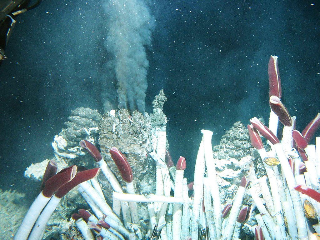
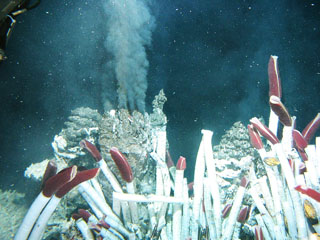 Fluid containing precipitates rises from a "black smoker" chimney at the Tica vent at 9°N on the East Pacific Rise, photographed during a 2004 expedition sponsored by the National Science Foundation. Hot-vent animal communities (such as seen in the foreground of this image from the November to December 1989 expedition) were observed to have been buried by lava flows in 1991. Another eruption in 2005-2006 produced lava flows that covered seismometers.
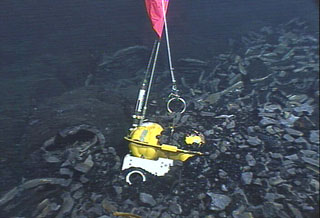 An eruption in 2005-2006 that covered 23 km2 of sea floor with lava at the East Pacific Rise encased three ocean-bottom seismometers. Scientists successfully recovered two seismometers that were deployed in 2003 with the remotely operated vehicle Jason during a National Science Foundation/Woods Hole Oceanographic Institution expedition in April 2007.
The Global Volcanism Program has no maps available for Northern EPR at 9.8°N.
There are no samples for Northern EPR at 9.8°N in the Smithsonian's NMNH Department of Mineral Sciences Rock and Ore collection.
| Copernicus Browser | The Copernicus Browser replaced the Sentinel Hub Playground browser in 2023, to provide access to Earth observation archives from the Copernicus Data Space Ecosystem, the main distribution platform for data from the EU Copernicus missions. |
| MIROVA | Middle InfraRed Observation of Volcanic Activity (MIROVA) is a near real time volcanic hot-spot detection system based on the analysis of MODIS (Moderate Resolution Imaging Spectroradiometer) data. In particular, MIROVA uses the Middle InfraRed Radiation (MIR), measured over target volcanoes, in order to detect, locate and measure the heat radiation sourced from volcanic activity. |
| MODVOLC Thermal Alerts | Using infrared satellite Moderate Resolution Imaging Spectroradiometer (MODIS) data, scientists at the Hawai'i Institute of Geophysics and Planetology, University of Hawai'i, developed an automated system called MODVOLC to map thermal hot-spots in near real time. For each MODIS image, the algorithm automatically scans each 1 km pixel within it to check for high-temperature hot-spots. When one is found the date, time, location, and intensity are recorded. MODIS looks at every square km of the Earth every 48 hours, once during the day and once during the night, and the presence of two MODIS sensors in space allows at least four hot-spot observations every two days. Each day updated global maps are compiled to display the locations of all hot spots detected in the previous 24 hours. There is a drop-down list with volcano names which allow users to 'zoom-in' and examine the distribution of hot-spots at a variety of spatial scales. |
|
WOVOdat
Single Volcano View Temporal Evolution of Unrest Side by Side Volcanoes |
WOVOdat is a database of volcanic unrest; instrumentally and visually recorded changes in seismicity, ground deformation, gas emission, and other parameters from their normal baselines. It is sponsored by the World Organization of Volcano Observatories (WOVO) and presently hosted at the Earth Observatory of Singapore.
GVMID Data on Volcano Monitoring Infrastructure The Global Volcano Monitoring Infrastructure Database GVMID, is aimed at documenting and improving capabilities of volcano monitoring from the ground and space. GVMID should provide a snapshot and baseline view of the techniques and instrumentation that are in place at various volcanoes, which can be use by volcano observatories as reference to setup new monitoring system or improving networks at a specific volcano. These data will allow identification of what monitoring gaps exist, which can be then targeted by remote sensing infrastructure and future instrument deployments. |
| Volcanic Hazard Maps | The IAVCEI Commission on Volcanic Hazards and Risk has a Volcanic Hazard Maps database designed to serve as a resource for hazard mappers (or other interested parties) to explore how common issues in hazard map development have been addressed at different volcanoes, in different countries, for different hazards, and for different intended audiences. In addition to the comprehensive, searchable Volcanic Hazard Maps Database, this website contains information about diversity of volcanic hazard maps, illustrated using examples from the database. This site is for educational purposes related to volcanic hazard maps. Hazard maps found on this website should not be used for emergency purposes. For the most recent, official hazard map for a particular volcano, please seek out the proper institutional authorities on the matter. |
| IRIS seismic stations/networks | Incorporated Research Institutions for Seismology (IRIS) Data Services map showing the location of seismic stations from all available networks (permanent or temporary) within a radius of 0.18° (about 20 km at mid-latitudes) from the given location of Northern EPR at 9.8°N. Users can customize a variety of filters and options in the left panel. Note that if there are no stations are known the map will default to show the entire world with a "No data matched request" error notice. |
| UNAVCO GPS/GNSS stations | Geodetic Data Services map from UNAVCO showing the location of GPS/GNSS stations from all available networks (permanent or temporary) within a radius of 20 km from the given location of Northern EPR at 9.8°N. Users can customize the data search based on station or network names, location, and time window. Requires Adobe Flash Player. |
| DECADE Data | The DECADE portal, still in the developmental stage, serves as an example of the proposed interoperability between The Smithsonian Institution's Global Volcanism Program, the Mapping Gas Emissions (MaGa) Database, and the EarthChem Geochemical Portal. The Deep Earth Carbon Degassing (DECADE) initiative seeks to use new and established technologies to determine accurate global fluxes of volcanic CO2 to the atmosphere, but installing CO2 monitoring networks on 20 of the world's 150 most actively degassing volcanoes. The group uses related laboratory-based studies (direct gas sampling and analysis, melt inclusions) to provide new data for direct degassing of deep earth carbon to the atmosphere. |
| Large Eruptions of Northern EPR at 9.8°N | Information about large Quaternary eruptions (VEI >= 4) is cataloged in the Large Magnitude Explosive Volcanic Eruptions (LaMEVE) database of the Volcano Global Risk Identification and Analysis Project (VOGRIPA). |
| EarthChem | EarthChem develops and maintains databases, software, and services that support the preservation, discovery, access and analysis of geochemical data, and facilitate their integration with the broad array of other available earth science parameters. EarthChem is operated by a joint team of disciplinary scientists, data scientists, data managers and information technology developers who are part of the NSF-funded data facility Integrated Earth Data Applications (IEDA). IEDA is a collaborative effort of EarthChem and the Marine Geoscience Data System (MGDS). |

