
Tectonic earthquake swarm in late 1998
Tenorio volcano is located between Rincón de la Vieja (to the NW) and Arenal (to the SE). This region now has a new telemetric, digital seismic network consisting of six stations. Although not well instrumented for seismic measurements, Tenorio normally has very little seismic activity. In contrast to this historically moderate seismicity, an earthquake swarm with many tectonic events was recorded at both Tenorio and nearby Miravalles volcano during October and November 1997 (BGVN 22:10).
During October-November 1998 a total of 170 microearthquakes were recorded in the Tenorio area, 82 of which were located. Most events were recorded during 17-23 October, with up to 10 felt by people near the epicenter in Tierras Morenas (Barquero and Taylor, 1998). Magnitudes were 0.9-3.3 at depths of 0.5-10 km (most <2 km) and a maximum intensity of MM IV.
Within the Tenorio area are several fault systems oriented mainly NW-SE and NE-SW. There are also complex old volcanic caldera structures. The seismic swarms recorded in 1997 and 1998 denoted tectonic activity in these fault systems, considered neotectonic structures, and so they are not thought to be related to volcanic activity.
References. Barquero, R., and Taylor, W., 1998, Proyecto Geotérmico Tenorio: Los enjambres sísmicos periodo octubre-noviembre de 1997 y 1998: Informe preliminar. Inf. OSV 98.11 ICE, 15 p.
Further References. Boschini, I., 1998, Análisis preliminar del enjambre de sismos de la región de Miravalles-Tenorio de octubre y noviembre de 1997: Inf. OSV 98.08 ICE, 36 p.
ENEL, 1990: Estudios de reconocimiento y prefactibilidad geotérmica en la República de Costa Rica. Fase II. Estudio de prefactiblidad del area de Tenorio: Informe de Síntesis, 66 p.
ICE-ELC, 1983, informe geo-vulcanológico, Pyrotecto Geotérmico Miravalles: Informe interno ICE, 53 p.
Guillot, P.Y., Chiesa, S., and Alvarado, G., 1994, Chronostratigraphy of Upper Miocene-Quaternary volcanism in northern Costa Rica: Rev. Geol. Amér. Central, v. 17, p. 45-53.
Information Contacts: Rafael Barquero, Observatorio Sismológico y Vulcanológico Arenal-Miravalles (OSIVAM), Instituo Costaricense de Electricidad (ICE), Apdo. 10032-1000, San José, Costa Rica.
The Global Volcanism Program has no Weekly Reports available for Tenorio.
Reports are organized chronologically and indexed below by Month/Year (Publication Volume:Number), and include a one-line summary. Click on the index link or scroll down to read the reports.
Small earthquake swarms near summit and SSW flank
During 5-27 October, 14 earthquakes were located on a 5-km-long SE-NW trend from the summit of Tenorio (figure 1). The swarm, centered around 10.7°N, 85.03°W, was possibly associated with known faults. The earthquakes had depths of 5-10 km and magnitudes of 0.6-2.1.
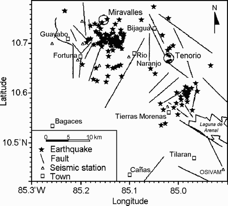 |
Figure 1. Major faults in the Guanacaste Range of Costa Rica and October earthquake locations around Miravalles and Tenorio volcanoes. During 5-27 October, 620 earthquakes were recorded, but only 187 could be located. Courtesy of ICE. |
An unrelated swarm consisting of 27 events occurred during the same period near the village of Tierras Morenas at the SSW foot of Tenorio. The swarm was centered at 10.6°N, 85.0°W and was aligned along a 7-km NE-SW trend, possibly correlating to known faults. The earthquakes had depths of 7-12 km and magnitudes of 0.4-3.3.
Information Contacts: Gerardo J. Soto and Waldo Taylor, Oficina de Sismología y Vulcanología, Departamento de Geología, Instituto Costarricense de Electricidad (ICE), Apartado 10032-1000, San José, Costa Rica.
Tectonic earthquake swarm in late 1998
Tenorio volcano is located between Rincón de la Vieja (to the NW) and Arenal (to the SE). This region now has a new telemetric, digital seismic network consisting of six stations. Although not well instrumented for seismic measurements, Tenorio normally has very little seismic activity. In contrast to this historically moderate seismicity, an earthquake swarm with many tectonic events was recorded at both Tenorio and nearby Miravalles volcano during October and November 1997 (BGVN 22:10).
During October-November 1998 a total of 170 microearthquakes were recorded in the Tenorio area, 82 of which were located. Most events were recorded during 17-23 October, with up to 10 felt by people near the epicenter in Tierras Morenas (Barquero and Taylor, 1998). Magnitudes were 0.9-3.3 at depths of 0.5-10 km (most <2 km) and a maximum intensity of MM IV.
Within the Tenorio area are several fault systems oriented mainly NW-SE and NE-SW. There are also complex old volcanic caldera structures. The seismic swarms recorded in 1997 and 1998 denoted tectonic activity in these fault systems, considered neotectonic structures, and so they are not thought to be related to volcanic activity.
References. Barquero, R., and Taylor, W., 1998, Proyecto Geotérmico Tenorio: Los enjambres sísmicos periodo octubre-noviembre de 1997 y 1998: Informe preliminar. Inf. OSV 98.11 ICE, 15 p.
Further References. Boschini, I., 1998, Análisis preliminar del enjambre de sismos de la región de Miravalles-Tenorio de octubre y noviembre de 1997: Inf. OSV 98.08 ICE, 36 p.
ENEL, 1990: Estudios de reconocimiento y prefactibilidad geotérmica en la República de Costa Rica. Fase II. Estudio de prefactiblidad del area de Tenorio: Informe de Síntesis, 66 p.
ICE-ELC, 1983, informe geo-vulcanológico, Pyrotecto Geotérmico Miravalles: Informe interno ICE, 53 p.
Guillot, P.Y., Chiesa, S., and Alvarado, G., 1994, Chronostratigraphy of Upper Miocene-Quaternary volcanism in northern Costa Rica: Rev. Geol. Amér. Central, v. 17, p. 45-53.
Information Contacts: Rafael Barquero, Observatorio Sismológico y Vulcanológico Arenal-Miravalles (OSIVAM), Instituo Costaricense de Electricidad (ICE), Apdo. 10032-1000, San José, Costa Rica.
|
|
||||||||||||||||||||||||||||
The Global Volcanism Program is not aware of any Holocene eruptions from Tenorio. If this volcano has had large eruptions (VEI >= 4) prior to 12,000 years ago, information might be found on the Tenorio page in the LaMEVE (Large Magnitude Explosive Volcanic Eruptions) database, a part of the Volcano Global Risk Identification and Analysis Project (VOGRIPA).
This compilation of synonyms and subsidiary features may not be comprehensive. Features are organized into four major categories: Cones, Craters, Domes, and Thermal Features. Synonyms of features appear indented below the primary name. In some cases additional feature type, elevation, or location details are provided.
Cones |
||||
| Feature Name | Feature Type | Elevation | Latitude | Longitude |
| Barrera, Cerro | Cone | 720 m | 10° 35' 54.00" N | 85° 3' 12.00" W |
| Montezuma, Cerro | Stratovolcano | 1513 m | 10° 41' 30.00" N | 85° 1' 36.00" W |
| Olla de Carne | Cone | 454 m | 10° 42' 29.00" N | 85° 4' 1.00" W |
Domes |
||||
| Feature Name | Feature Type | Elevation | Latitude | Longitude |
| Bijagua | Dome | 700 m | 10° 43' 12.00" N | 85° 1' 26.00" W |
Thermal |
||||
| Feature Name | Feature Type | Elevation | Latitude | Longitude |
| Casas, Las | Thermal | |||
| Herivderos, Los | Thermal | 700 m | ||
| Quemadas, Los | Thermal | 965 m | ||
 The verdant forests mantling the Tenorio volcanic complex are seen from the Río Celeste drainage. The Tenorio complex consists of five volcanic cones aligned NNW-SSE. Several archaeological sites are located around the complex, testament to the importance of the area to prehispanic Indians. The Tenorio complex marks the SE end of the Guanacaste Range; a range of low hills separates it from the next volcano to the SE, Arenal.
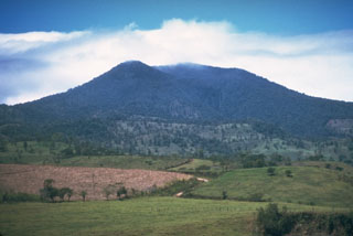 The forested Tenorio volcanic complex contains a group of volcanic cones at the SE end of the Guanacaste Range. Geothermal activity is present on the NE flank.
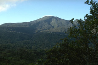 Vegetation covers overlapping lava flows that descend the NE flank of the Tenorio volcanic complex. The summit of Volcán Tenorio, the highest peak of the complex, has two small craters.
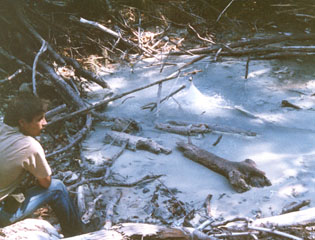 La Casa thermal spring is located in El Roble thermal area on the NE flank of the Tenorio volcanic complex. At the nearby Los Quemados thermal area 1 km to the south, vegetation has been destroyed over an area of 2,500 m2, and geothermal activity has killed small animals.
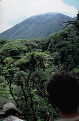
 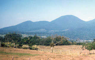 Cerro Montezuma volcano in the Tenorio volcanic complex is seen here from the SW. The Tenorio complex marks the SE limit of the Guanacaste Range, which extends NW towards the Nicaragua border. This complex of five volcanic cones along a NNW-SSE trend has a cluster of volcanic domes at its northern end. No confirmed historical eruptions have occurred at Tenorio. Despite the report of a volcanic eruption in 1816, the volcano was densely forested at the time of its December 1864 visit by Seebach.
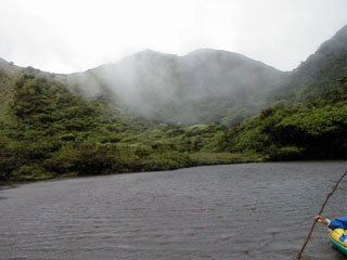 Wispy clouds cling to the walls of Tenorio's crater lake. This densely forested volcano provides habitat for some of Costa Rica's most exotic wildlife, including pumas, jaguars, tapirs, and a wide variety of bird life. Heavy rainfall in this forested terrain feeds crystalline waters that are important in regional hydrology.
The following 38 samples associated with this volcano can be found in the Smithsonian's NMNH Department of Mineral Sciences collections, and may be availble for research (contact the Rock and Ore Collections Manager). Catalog number links will open a window with more information.
| Catalog Number | Sample Description | Lava Source | Collection Date |
|---|---|---|---|
| NMNH 116066-203 | Lapilli | -- | 7 Mar 1985 |
| NMNH 116066-204 | Tephra | -- | 7 Mar 1985 |
| NMNH 116066-209 | Pumice | -- | 7 Mar 1985 |
| NMNH 116066-245 | Carbonized Wood | -- | 9 Mar 1985 |
| NMNH 116066-251 | Pumice Lapilli | -- | 12 Mar 1985 |
| NMNH 116066-254 | Lapilli | -- | 12 Mar 1985 |
| NMNH 116066-257 | Lapilli | -- | 12 Mar 1985 |
| NMNH 116066-258 | Lapilli | -- | 12 Mar 1985 |
| NMNH 116066-260 | Lapilli | -- | 12 Mar 1985 |
| NMNH 116066-262 | Tephra | -- | 12 Mar 1985 |
| NMNH 116066-263 | Lapilli | -- | 12 Mar 1985 |
| NMNH 116066-265 | Lapilli | -- | 12 Mar 1985 |
| NMNH 116066-266 | Tephra | -- | 12 Mar 1985 |
| NMNH 116066-267 | Lapilli | -- | 12 Mar 1985 |
| NMNH 116066-268 | Tephra | -- | 12 Mar 1985 |
| NMNH 116066-269 | Tephra | -- | 12 Mar 1985 |
| NMNH 116066-270 | Lapilli | -- | 12 Mar 1985 |
| NMNH 116066-271 | Tephra | -- | 12 Mar 1985 |
| NMNH 116066-272 | Lapilli | -- | 12 Mar 1985 |
| NMNH 116066-273 | Lapilli | -- | 12 Mar 1985 |
| NMNH 116066-274 | Tephra | -- | 12 Mar 1985 |
| NMNH 116066-277 | Basaltic Andesite | -- | 12 Mar 1985 |
| NMNH 116066-280 | Ignimbrite | -- | 13 Mar 1985 |
| NMNH 116066-281 | Ignimbrite | -- | 13 Mar 1985 |
| NMNH 116066-282 | Carbonized Wood | -- | 13 Mar 1985 |
| NMNH 116066-286 | Pumice Lapilli | -- | 13 Mar 1985 |
| NMNH 116066-289 | Lapilli | -- | 13 Mar 1985 |
| NMNH 116066-295 | Tephra | -- | 13 Mar 1985 |
| NMNH 116066-296 | Tephra | -- | 13 Mar 1985 |
| NMNH 116066-331 | Andesite | -- | 17 Mar 1985 |
| NMNH 116066-332 | Andesite | -- | 17 Mar 1985 |
| NMNH 116066-335 | Andesite | -- | 17 Mar 1985 |
| NMNH 116066-336 | Fumarole Minerals | -- | 17 Mar 1985 |
| NMNH 116066-337 | Fumarole Minerals | -- | 17 Mar 1985 |
| NMNH 116066-338 | Andesite | -- | 17 Mar 1985 |
| NMNH 116066-341 | Andesite | -- | 17 Mar 1985 |
| NMNH 116066-342 | Tephra | -- | 17 Mar 1985 |
| NMNH 116066-343 | Andesite | -- | 17 Mar 1985 |
| Copernicus Browser | The Copernicus Browser replaced the Sentinel Hub Playground browser in 2023, to provide access to Earth observation archives from the Copernicus Data Space Ecosystem, the main distribution platform for data from the EU Copernicus missions. |
| MIROVA | Middle InfraRed Observation of Volcanic Activity (MIROVA) is a near real time volcanic hot-spot detection system based on the analysis of MODIS (Moderate Resolution Imaging Spectroradiometer) data. In particular, MIROVA uses the Middle InfraRed Radiation (MIR), measured over target volcanoes, in order to detect, locate and measure the heat radiation sourced from volcanic activity. |
| MODVOLC Thermal Alerts | Using infrared satellite Moderate Resolution Imaging Spectroradiometer (MODIS) data, scientists at the Hawai'i Institute of Geophysics and Planetology, University of Hawai'i, developed an automated system called MODVOLC to map thermal hot-spots in near real time. For each MODIS image, the algorithm automatically scans each 1 km pixel within it to check for high-temperature hot-spots. When one is found the date, time, location, and intensity are recorded. MODIS looks at every square km of the Earth every 48 hours, once during the day and once during the night, and the presence of two MODIS sensors in space allows at least four hot-spot observations every two days. Each day updated global maps are compiled to display the locations of all hot spots detected in the previous 24 hours. There is a drop-down list with volcano names which allow users to 'zoom-in' and examine the distribution of hot-spots at a variety of spatial scales. |
|
WOVOdat
Single Volcano View Temporal Evolution of Unrest Side by Side Volcanoes |
WOVOdat is a database of volcanic unrest; instrumentally and visually recorded changes in seismicity, ground deformation, gas emission, and other parameters from their normal baselines. It is sponsored by the World Organization of Volcano Observatories (WOVO) and presently hosted at the Earth Observatory of Singapore.
GVMID Data on Volcano Monitoring Infrastructure The Global Volcano Monitoring Infrastructure Database GVMID, is aimed at documenting and improving capabilities of volcano monitoring from the ground and space. GVMID should provide a snapshot and baseline view of the techniques and instrumentation that are in place at various volcanoes, which can be use by volcano observatories as reference to setup new monitoring system or improving networks at a specific volcano. These data will allow identification of what monitoring gaps exist, which can be then targeted by remote sensing infrastructure and future instrument deployments. |
| Volcanic Hazard Maps | The IAVCEI Commission on Volcanic Hazards and Risk has a Volcanic Hazard Maps database designed to serve as a resource for hazard mappers (or other interested parties) to explore how common issues in hazard map development have been addressed at different volcanoes, in different countries, for different hazards, and for different intended audiences. In addition to the comprehensive, searchable Volcanic Hazard Maps Database, this website contains information about diversity of volcanic hazard maps, illustrated using examples from the database. This site is for educational purposes related to volcanic hazard maps. Hazard maps found on this website should not be used for emergency purposes. For the most recent, official hazard map for a particular volcano, please seek out the proper institutional authorities on the matter. |
| IRIS seismic stations/networks | Incorporated Research Institutions for Seismology (IRIS) Data Services map showing the location of seismic stations from all available networks (permanent or temporary) within a radius of 0.18° (about 20 km at mid-latitudes) from the given location of Tenorio. Users can customize a variety of filters and options in the left panel. Note that if there are no stations are known the map will default to show the entire world with a "No data matched request" error notice. |
| UNAVCO GPS/GNSS stations | Geodetic Data Services map from UNAVCO showing the location of GPS/GNSS stations from all available networks (permanent or temporary) within a radius of 20 km from the given location of Tenorio. Users can customize the data search based on station or network names, location, and time window. Requires Adobe Flash Player. |
| DECADE Data | The DECADE portal, still in the developmental stage, serves as an example of the proposed interoperability between The Smithsonian Institution's Global Volcanism Program, the Mapping Gas Emissions (MaGa) Database, and the EarthChem Geochemical Portal. The Deep Earth Carbon Degassing (DECADE) initiative seeks to use new and established technologies to determine accurate global fluxes of volcanic CO2 to the atmosphere, but installing CO2 monitoring networks on 20 of the world's 150 most actively degassing volcanoes. The group uses related laboratory-based studies (direct gas sampling and analysis, melt inclusions) to provide new data for direct degassing of deep earth carbon to the atmosphere. |
| Large Eruptions of Tenorio | Information about large Quaternary eruptions (VEI >= 4) is cataloged in the Large Magnitude Explosive Volcanic Eruptions (LaMEVE) database of the Volcano Global Risk Identification and Analysis Project (VOGRIPA). |
| EarthChem | EarthChem develops and maintains databases, software, and services that support the preservation, discovery, access and analysis of geochemical data, and facilitate their integration with the broad array of other available earth science parameters. EarthChem is operated by a joint team of disciplinary scientists, data scientists, data managers and information technology developers who are part of the NSF-funded data facility Integrated Earth Data Applications (IEDA). IEDA is a collaborative effort of EarthChem and the Marine Geoscience Data System (MGDS). |

