
The Global Volcanism Program has no activity reports available for Isla del Coco.
The Global Volcanism Program has no Weekly Reports available for Isla del Coco.
The Global Volcanism Program has no Bulletin Reports available for Isla del Coco.
|
|
||||||||||||||||||
The Global Volcanism Program is not aware of any Holocene eruptions from Isla del Coco. If this volcano has had large eruptions (VEI >= 4) prior to 12,000 years ago, information might be found on the Isla del Coco page in the LaMEVE (Large Magnitude Explosive Volcanic Eruptions) database, a part of the Volcano Global Risk Identification and Analysis Project (VOGRIPA).
This compilation of synonyms and subsidiary features may not be comprehensive. Features are organized into four major categories: Cones, Craters, Domes, and Thermal Features. Synonyms of features appear indented below the primary name. In some cases additional feature type, elevation, or location details are provided.
Synonyms |
||||
| Cocos Island | Coques, Ile de | ||||
Cones |
||||
| Feature Name | Feature Type | Elevation | Latitude | Longitude |
| Iglesias | Shield volcano | 624 m | 5° 32' 0.00" N | 87° 4' 52.00" W |
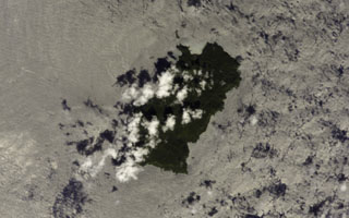 Clouds partially obscure the 22 km2 Isla del Coco (Cocos Island) in this NASA International Space Station image. Chathan Bay (top) lies off the NE tip of the island, which sits astride the Cocos Ridge about 650 km SW of the Costa Rican port of Puntarenas. The rain-drenched island is renowned as the site of treasures buried by pirates and ship captains. Construction of a Pliocene-Pleistocene shield volcano was followed by caldera formation and the emplacement of a trachytic lava dome.
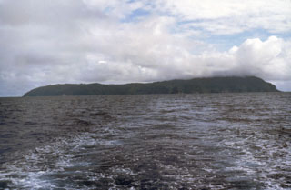 The low profile of Isla del Coco is seen from the NE, taken from the R/V Searcher of the University of Costa Rica. The 22 km2 rain-drenched island was discovered by the Spanish pilot Juan Cabezas around 1526 CE, and the Costa Rican flag was first planted on the island in 1869. Isla del Coco is the only subaerial portion of the Cocos Ridge, which extends from the Galápagos hot spot to the Mesoamerican trench. Construction of a Pliocene-Pleistocene shield volcano was followed by caldera formation and the emplacement of a trachytic lava dome.
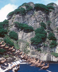 Outcrops of trachyte form cliffs on the northern side of Isla Coco. Seabirds perch on lines of the R/V Searcher of the University of Costa Rica. A massive trachytic lava dome lies between Bahia Wafer and Bahia Chathan on the NE side of the island.
 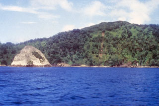 The light-colored pyramidal island at the left is a small island of trachytic rocks between Bahia Wafer and Bahia Chathan, on the NE side of Cocos Island. The plug-like islet lies north of a massive lava dome lying between the two bays and consisting of flow-banded benmoreitic, trachytic, and quartz trachytic rocks.
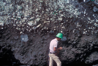 Geologist Eric Fernandez examines an outcrop of pyroclastic rocks along the banks of the Río Genio, on the northern side of Cocos Island. Pyroclastic rocks were erupted either immediately prior to or contemporaneously with trachytic rocks forming a lava dome. Pyroclastic rocks are thickest on the northern side of the island, which may represent the topographic high of the old seamount.
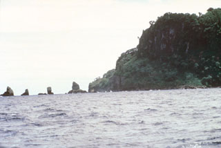 Erosional remnants of the widespread pyroclastic rock unit at the NW corner of Cocos Island form small offshore islets. Pyroclastic rock units are thickest at the NE side of the island, south of the large trachytic lava dome between Bahia Wafer and Bahia Chathan, but are also exposed along the NW, SW, and southern coasts, and in the SW and eastern interior of the island.
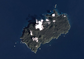 The 22 km2 Isla del Coco (Cocos Islands) is the subaerial portion of the Cocos Ridge, shown in this December 2019 Planet Labs satellite image monthly mosaic (N is at the top). A Pliocene-Pleistocene shield volcano partly forms the roughly 7-km-long (in the NE-SW direction) island. Steep cliffs around the coast expose thick columnar-jointed lava flows, thin lavas, and breccias (possibly debris flows).
There are no samples for Isla del Coco in the Smithsonian's NMNH Department of Mineral Sciences Rock and Ore collection.
| Copernicus Browser | The Copernicus Browser replaced the Sentinel Hub Playground browser in 2023, to provide access to Earth observation archives from the Copernicus Data Space Ecosystem, the main distribution platform for data from the EU Copernicus missions. |
|
WOVOdat
Single Volcano View Temporal Evolution of Unrest Side by Side Volcanoes |
WOVOdat is a database of volcanic unrest; instrumentally and visually recorded changes in seismicity, ground deformation, gas emission, and other parameters from their normal baselines. It is sponsored by the World Organization of Volcano Observatories (WOVO) and presently hosted at the Earth Observatory of Singapore.
GVMID Data on Volcano Monitoring Infrastructure The Global Volcano Monitoring Infrastructure Database GVMID, is aimed at documenting and improving capabilities of volcano monitoring from the ground and space. GVMID should provide a snapshot and baseline view of the techniques and instrumentation that are in place at various volcanoes, which can be use by volcano observatories as reference to setup new monitoring system or improving networks at a specific volcano. These data will allow identification of what monitoring gaps exist, which can be then targeted by remote sensing infrastructure and future instrument deployments. |
| IRIS seismic stations/networks | Incorporated Research Institutions for Seismology (IRIS) Data Services map showing the location of seismic stations from all available networks (permanent or temporary) within a radius of 0.18° (about 20 km at mid-latitudes) from the given location of Isla del Coco. Users can customize a variety of filters and options in the left panel. Note that if there are no stations are known the map will default to show the entire world with a "No data matched request" error notice. |
| UNAVCO GPS/GNSS stations | Geodetic Data Services map from UNAVCO showing the location of GPS/GNSS stations from all available networks (permanent or temporary) within a radius of 20 km from the given location of Isla del Coco. Users can customize the data search based on station or network names, location, and time window. Requires Adobe Flash Player. |
| Large Eruptions of Isla del Coco | Information about large Quaternary eruptions (VEI >= 4) is cataloged in the Large Magnitude Explosive Volcanic Eruptions (LaMEVE) database of the Volcano Global Risk Identification and Analysis Project (VOGRIPA). |
| EarthChem | EarthChem develops and maintains databases, software, and services that support the preservation, discovery, access and analysis of geochemical data, and facilitate their integration with the broad array of other available earth science parameters. EarthChem is operated by a joint team of disciplinary scientists, data scientists, data managers and information technology developers who are part of the NSF-funded data facility Integrated Earth Data Applications (IEDA). IEDA is a collaborative effort of EarthChem and the Marine Geoscience Data System (MGDS). |

