The Global Volcanism Program has no activity reports available for Lanzarote.
The Global Volcanism Program has no Weekly Reports available for Lanzarote.
The Global Volcanism Program has no Bulletin Reports available for Lanzarote.
|
|
||||||||||||||||||||||||||||
There is data available for 4 confirmed eruptive periods.
1824 Jul 31 - 1824 Oct 24 Confirmed Eruption (Explosive / Effusive) VEI: 2
| Episode 1 | Eruption (Explosive / Effusive) | Tao, Nuevo del Fuego, Tinguatón | ||||||||||||||||||||||||||||||||||||||||||||||||
|---|---|---|---|---|---|---|---|---|---|---|---|---|---|---|---|---|---|---|---|---|---|---|---|---|---|---|---|---|---|---|---|---|---|---|---|---|---|---|---|---|---|---|---|---|---|---|---|---|---|
| 1824 Jul 31 - 1824 Oct 24 | Evidence from Observations: Reported | ||||||||||||||||||||||||||||||||||||||||||||||||
|
List of 8 Events for Episode 1 at Tao, Nuevo del Fuego, Tinguatón
|
|||||||||||||||||||||||||||||||||||||||||||||||||
1730 Sep 1 - 1736 Apr 16 Confirmed Eruption (Explosive / Effusive) VEI: 3
| Episode 1 | Eruption (Explosive / Effusive) | Montañas del Fuego | |||||||||||||||||||||||||||||||||||||||||||||||||||||||||||||||||||||||||
|---|---|---|---|---|---|---|---|---|---|---|---|---|---|---|---|---|---|---|---|---|---|---|---|---|---|---|---|---|---|---|---|---|---|---|---|---|---|---|---|---|---|---|---|---|---|---|---|---|---|---|---|---|---|---|---|---|---|---|---|---|---|---|---|---|---|---|---|---|---|---|---|---|---|---|
| 1730 Sep 1 - 1736 Apr 16 | Evidence from Observations: Reported | |||||||||||||||||||||||||||||||||||||||||||||||||||||||||||||||||||||||||
|
List of 13 Events for Episode 1 at Montañas del Fuego
|
||||||||||||||||||||||||||||||||||||||||||||||||||||||||||||||||||||||||||
0700 ± 50 years Confirmed Eruption (Explosive / Effusive)
| Episode 1 | Eruption (Explosive / Effusive) | Mazo, Santa Catalina, Corazoncillo | |||||||||||||||||||||||
|---|---|---|---|---|---|---|---|---|---|---|---|---|---|---|---|---|---|---|---|---|---|---|---|---|
| 0700 ± 50 years - Unknown | Evidence from Correlation: Magnetism | |||||||||||||||||||||||
|
List of 3 Events for Episode 1 at Mazo, Santa Catalina, Corazoncillo
|
||||||||||||||||||||||||
0500 ± 50 years Confirmed Eruption (Explosive / Effusive)
| Episode 1 | Eruption (Explosive / Effusive) | Montaña de Juan Perdomo | |||||||||||||||||||||||
|---|---|---|---|---|---|---|---|---|---|---|---|---|---|---|---|---|---|---|---|---|---|---|---|---|
| 0500 ± 50 years - Unknown | Evidence from Correlation: Magnetism | |||||||||||||||||||||||
|
List of 3 Events for Episode 1 at Montaña de Juan Perdomo
|
||||||||||||||||||||||||
This compilation of synonyms and subsidiary features may not be comprehensive. Features are organized into four major categories: Cones, Craters, Domes, and Thermal Features. Synonyms of features appear indented below the primary name. In some cases additional feature type, elevation, or location details are provided.
Synonyms |
||||
| Timanfaya, Montanas del | ||||
Cones |
||||
| Feature Name | Feature Type | Elevation | Latitude | Longitude |
| Amarilla, Montaña | Cone | 172 m | 29° 13' 0.00" N | 13° 32' 0.00" W |
| Bermeja, Montaña | Cone | 157 m | 29° 17' 0.00" N | 13° 31' 0.00" W |
| Blanca, Montaña | Cone | 556 m | 28° 59' 0.00" N | 13° 38' 0.00" W |
| Clara, Montaña | Cone | 256 m | 29° 17' 0.00" N | 13° 32' 0.00" W |
| Corona, Monte | Cone - Crater | 609 m | 29° 11' 0.00" N | 13° 29' 0.00" W |
| Fuego, Montañas del | Cone - Crater | 510 m | 28° 59' 31.00" N | 13° 44' 31.00" W |
| Guatisea, Montaña | Cone | 544 m | 28° 56' 0.00" N | 13° 38' 0.00" W |
| Helechos, Los | Cone | 581 m | 29° 10' 0.00" N | 13° 30' 0.00" W |
| Juan Perdomo, Montaña de | Cone | 129 m | 28° 59' 0.00" N | 13° 49' 0.00" W |
| Lobos, Montaña | Cone - Crater | 221 m | 29° 23' 0.00" N | 13° 30' 0.00" W |
| Mojon, Montaña del | Cone | 188 m | 29° 14' 0.00" N | 13° 30' 0.00" W |
| Morro de las Atalayas | Cone | 199 m | 29° 24' 0.00" N | 13° 30' 0.00" W |
| Partido, Pico | Cone - Crater | 517 m | 29° 0' 7.00" N | 13° 42' 7.00" W |
| Pedre Barba, Montaña de | Cone | 266 m | 29° 15' 0.00" N | 13° 30' 0.00" W |
| Roque de Infierno | Cone | 41 m | 29° 19' 0.00" N | 13° 31' 0.00" W |
| Tamia, Montaña | Cone | 550 m | 29° 2' 0.00" N | 13° 38' 0.00" W |
| Tao, Volcán de
Clerigo Duarte, Montaña del |
Cone - Crater | 303 m | 29° 2' 28.00" N | 13° 37' 0.00" W |
| Timanfaya Antigua | Cone | 28° 59' 0.00" N | 13° 41' 0.00" W | |
| Tinga, Montaña de | Cone | 402 m | 29° 0' 0.00" N | 13° 40' 52.00" W |
Craters |
||||
| Feature Name | Feature Type | Elevation | Latitude | Longitude |
| Blanca, Caldera | Crater - Cone | 458 m | 29° 2' 0.00" N | 13° 44' 0.00" W |
| Caldera, La | Crater - Cone | 289 m | 29° 24' 0.00" N | 13° 32' 0.00" W |
| Colorada, Caldera
Carcabullo o Pedregal |
Caldera | 465 m | 29° 0' 0.00" N | 13° 40' 34.00" W |
| Corazoncillo, Caldera del
Fuencaliente, Caldera de |
Crater - Cone | 424 m | 28° 59' 31.00" N | 13° 43' 41.00" W |
| Fuego de Timanfaya, Montañas del [Quemada | Crater - Cone | 510 m | 28° 59' 17.00" N | 13° 56' 20.00" W |
| Lapas, Caldera de las
Cuervo, the Cuervos, Caldera de los Cuervos, Montaña de los |
Caldera | 384 m | 28° 59' 6.00" N | 13° 41' 31.00" W |
| Nuevo del Fuego, Volcán
Negra, Montaña |
Caldera | 356 m | 29° 0' 14.00" N | 13° 40' 34.00" W |
| Quemada de Orzola, La | Crater | |||
| Quemadas, Las Calderas
Occidentales, Calderas |
Crater - Cone | 384 m | 28° 59' 17.00" N | 13° 56' 20.00" W |
| Quemado, Volcán de el | Crater | 75 m | 29° 59' 0.00" N | 13° 49' 0.00" W |
| Rajada, Caldera
Rajada, Montaña Quemada, Montaña |
Caldera | 225 m | 28° 59' 17.00" N | 13° 46' 59.00" W |
| Rodeos, Montana
Colorada, Montaña |
Caldera | 458 m | 28° 59' 31.00" N | 13° 43' 0.00" W |
| Roja de Mazo, Caldera
Mazo, Volcán de |
Caldera | 427 m | 29° 0' 47.00" N | 13° 44' 10.00" W |
| Santa Catalina, Caldera de | Crater | 29° 59' 0.00" N | 13° 42' 0.00" W | |
| Tinguaton
Nuevo, Volcán |
Crater - Cone | 330 m | 29° 0' 47.00" N | 13° 42' 32.00" W |
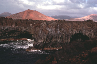 The 60-km-long island of Lanzarote at the NE end of the Canary Islands contains the largest concentration of youthful volcanism in the Canaries. Cinder cones and lava flows erupted along NE-SW-trending fissures in the Pleistocene and Holocene are found throughout the low-altitude arid island. The largest historical eruption of the Canary Islands took place during 1730-36, when long-term fissure-fed eruptions formed the Montañas del Fuego group of cinder cones and produced voluminous lava flows that covered about 200 km2.
 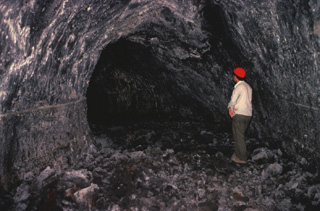 Volcanologist Maurice Krafft observes a lava tube on Lanzarote Island. Lava tubes provide an efficient means of transporting molten lava through subsurface channels that are thermally insulated from the surface. Many spectacular examples of lava tubes are found on Lanzarote, including the Ceuva de los Verdes lava-tube system, which extends more than 5 km from Volcán la Corona cinder cone to the Atlantic coast.
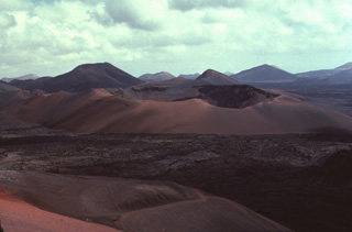 Caldera del Corazoncillo (center), also known as Caldera de Fuencaliente, was active during a two-week period in September 1730, which initiated the 1730-36 Montañas del Fuego eruption on Lanzarote. The NE-SW-trending eruptive fissures were located slightly west of the low crest of the island, and most of the extensive lava flows reached the coast along a broad 20-km-wide front on the western side of the island. Only one lava flow reached the eastern coast.
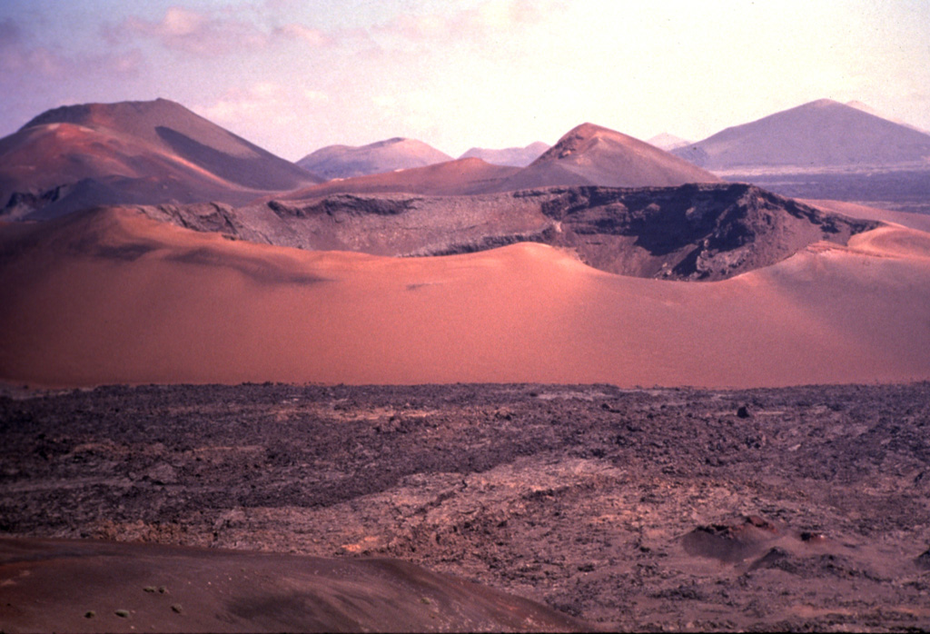
 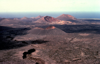 The largest historical eruption of the Canary Islands took place from 1730 to 1736, when a NE-SW-trending fissure formed the Montañas del Fuego ("Mountains of Fire"). Voluminous lava flows covering 200 km2 reached the western coast, seen in the distance, along a broad, 20-km-wide front. The villages of Maretas and Santa Catalina were destroyed, along with the most fertile valleys and estates of the island, which was entirely evacuated. Numerous cinder cones such as these dot the lava field, much of which lies within Timanfaya National Park.
 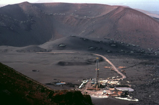 This geothermal drilling platform was part of an exploration program during the 1970's in Lanzarote's "Mountains of Fire." Residual heat from the 18th-century eruptions remains. Temperatures of 100 degrees centigrade were reached only a few cm below the surface, and a maximum temperature of 312 degrees was measured at a depth of 12 m.
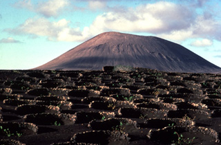 The circular stone-lined rings in the foreground of this Lanzarote cinder cone are the product of an innovative agricultural technique to enable crop growth on this arid, wind-swept island. Low stone walls constructed around small craterform depressions provide shelter from strong winds, permitting the growth of grape vines and fig trees.
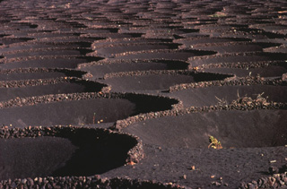 This geometric pattern in 18th-century ashfall deposits at Lanzarote is a human adaptation to permit agricultural use of this barren, wind-swept terrain. Grape vines and fig trees planted in shallow depressions excavated in the extensive pyroclastic-fall deposits are surrounded by low circular walls of volcanic blocks and bombs. This concentrates moisture in the finer-grained center of the pits and partially shelters the plants from the severe winds that sweep across the volcanic plain.
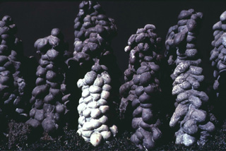 These unusual-looking lava stalagmites were formed when molten lava dripped from the ceiling of an active lava tube on Lanzarote Island. Corresponding lava stalactites hang from the ceiling of the lava tubes. The scale of these stalagmites is not stated, but may be a few tens of centimeters. Lava tubes are prominent features in the 1730-36 lava fields of Lanzarote.
 Circular Caldera del Corazoncillo (center) on Lanzarote, also known as Caldera de Fuencaliente, was active during a two-week period in September 1730, at the beginning of the 1730-36 Montañas del Fuego eruption. Lava flows effused from NE-SW-trending fissures and numerous cones (background), and reached the western side of the island over a 20-km-wide front, covering an area of about 250 km2.
 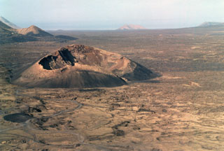 The Caldera de los Cuervos (left center) was formed during the initial stage of the eruption during 1730 to 1736. Eruptions from a 13-15 km long NE-SW trending fissure formed more than 30 cones and produced voluminous lava flows that covered about 250 km2, reaching the western coast. A third of the farmland and numerous villages were buried in ash during this six-year long eruption.
 The following 1 samples associated with this volcano can be found in the Smithsonian's NMNH Department of Mineral Sciences collections, and may be availble for research (contact the Rock and Ore Collections Manager). Catalog number links will open a window with more information.
| Catalog Number | Sample Description | Lava Source | Collection Date |
|---|---|---|---|
| NMNH 116691-12 | Lava | -- | -- |
| Copernicus Browser | The Copernicus Browser replaced the Sentinel Hub Playground browser in 2023, to provide access to Earth observation archives from the Copernicus Data Space Ecosystem, the main distribution platform for data from the EU Copernicus missions. |
| MIROVA | Middle InfraRed Observation of Volcanic Activity (MIROVA) is a near real time volcanic hot-spot detection system based on the analysis of MODIS (Moderate Resolution Imaging Spectroradiometer) data. In particular, MIROVA uses the Middle InfraRed Radiation (MIR), measured over target volcanoes, in order to detect, locate and measure the heat radiation sourced from volcanic activity. |
| MODVOLC Thermal Alerts | Using infrared satellite Moderate Resolution Imaging Spectroradiometer (MODIS) data, scientists at the Hawai'i Institute of Geophysics and Planetology, University of Hawai'i, developed an automated system called MODVOLC to map thermal hot-spots in near real time. For each MODIS image, the algorithm automatically scans each 1 km pixel within it to check for high-temperature hot-spots. When one is found the date, time, location, and intensity are recorded. MODIS looks at every square km of the Earth every 48 hours, once during the day and once during the night, and the presence of two MODIS sensors in space allows at least four hot-spot observations every two days. Each day updated global maps are compiled to display the locations of all hot spots detected in the previous 24 hours. There is a drop-down list with volcano names which allow users to 'zoom-in' and examine the distribution of hot-spots at a variety of spatial scales. |
|
WOVOdat
Single Volcano View Temporal Evolution of Unrest Side by Side Volcanoes |
WOVOdat is a database of volcanic unrest; instrumentally and visually recorded changes in seismicity, ground deformation, gas emission, and other parameters from their normal baselines. It is sponsored by the World Organization of Volcano Observatories (WOVO) and presently hosted at the Earth Observatory of Singapore.
GVMID Data on Volcano Monitoring Infrastructure The Global Volcano Monitoring Infrastructure Database GVMID, is aimed at documenting and improving capabilities of volcano monitoring from the ground and space. GVMID should provide a snapshot and baseline view of the techniques and instrumentation that are in place at various volcanoes, which can be use by volcano observatories as reference to setup new monitoring system or improving networks at a specific volcano. These data will allow identification of what monitoring gaps exist, which can be then targeted by remote sensing infrastructure and future instrument deployments. |
| Volcanic Hazard Maps | The IAVCEI Commission on Volcanic Hazards and Risk has a Volcanic Hazard Maps database designed to serve as a resource for hazard mappers (or other interested parties) to explore how common issues in hazard map development have been addressed at different volcanoes, in different countries, for different hazards, and for different intended audiences. In addition to the comprehensive, searchable Volcanic Hazard Maps Database, this website contains information about diversity of volcanic hazard maps, illustrated using examples from the database. This site is for educational purposes related to volcanic hazard maps. Hazard maps found on this website should not be used for emergency purposes. For the most recent, official hazard map for a particular volcano, please seek out the proper institutional authorities on the matter. |
| IRIS seismic stations/networks | Incorporated Research Institutions for Seismology (IRIS) Data Services map showing the location of seismic stations from all available networks (permanent or temporary) within a radius of 0.18° (about 20 km at mid-latitudes) from the given location of Lanzarote. Users can customize a variety of filters and options in the left panel. Note that if there are no stations are known the map will default to show the entire world with a "No data matched request" error notice. |
| UNAVCO GPS/GNSS stations | Geodetic Data Services map from UNAVCO showing the location of GPS/GNSS stations from all available networks (permanent or temporary) within a radius of 20 km from the given location of Lanzarote. Users can customize the data search based on station or network names, location, and time window. Requires Adobe Flash Player. |
| DECADE Data | The DECADE portal, still in the developmental stage, serves as an example of the proposed interoperability between The Smithsonian Institution's Global Volcanism Program, the Mapping Gas Emissions (MaGa) Database, and the EarthChem Geochemical Portal. The Deep Earth Carbon Degassing (DECADE) initiative seeks to use new and established technologies to determine accurate global fluxes of volcanic CO2 to the atmosphere, but installing CO2 monitoring networks on 20 of the world's 150 most actively degassing volcanoes. The group uses related laboratory-based studies (direct gas sampling and analysis, melt inclusions) to provide new data for direct degassing of deep earth carbon to the atmosphere. |
| Large Eruptions of Lanzarote | Information about large Quaternary eruptions (VEI >= 4) is cataloged in the Large Magnitude Explosive Volcanic Eruptions (LaMEVE) database of the Volcano Global Risk Identification and Analysis Project (VOGRIPA). |
| EarthChem | EarthChem develops and maintains databases, software, and services that support the preservation, discovery, access and analysis of geochemical data, and facilitate their integration with the broad array of other available earth science parameters. EarthChem is operated by a joint team of disciplinary scientists, data scientists, data managers and information technology developers who are part of the NSF-funded data facility Integrated Earth Data Applications (IEDA). IEDA is a collaborative effort of EarthChem and the Marine Geoscience Data System (MGDS). |

