Armenia Volcanoes
A map display is currently under development.
Armenia has 5 Holocene volcanoes. Note that as a scientific organization we provide these listings for informational purposes only, with no international legal or policy implications. Volcanoes will be included on this list if they are within the boundaries of a country, on a shared boundary or area, in a remote territory, or within a maritime Exclusive Economic Zone. Bolded volcanoes have erupted within the past 20 years. Suggestions and data updates are always welcome ().
| Volcano Name | Last Eruption | Volcanic Region | Primary Landform |
|---|---|---|---|
| Aragats | Unknown - Evidence Credible | Caucasus Volcanic Province | Composite |
| Ghegham Volcanic Ridge | 1900 BCE | Caucasus Volcanic Province | Cluster |
| Porak | 778 BCE | Caucasus Volcanic Province | Cluster |
| Tskhouk-Karckar | 3000 BCE | Caucasus Volcanic Province | Cluster |
| Vaiyots-Sar | 2000 BCE | Caucasus Volcanic Province | Minor (Basaltic) |
Chronological listing of known Holocene eruptions (confirmed or uncertain) from volcanoes in Armenia. Bolded eruptions indicate continuing activity.
| Volcano Name | Start Date | Stop Date | Certainty | VEI | Evidence |
|---|---|---|---|---|---|
| Vaiyots-Sar | [0753] | [Unknown] | Uncertain | ||
| Porak | [0740 BCE ± 2 years] | [Unknown] | Uncertain | ||
| Porak | 0778 BCE ± 5 years | Unknown | Confirmed | Correlation: Anthropology | |
| Ghegham Volcanic Ridge | 1900 BCE ± 750 years | Unknown | Confirmed | 0 | Correlation: Anthropology |
| Vaiyots-Sar | 2000 BCE (?) ± 1000 years | Unknown | Confirmed | Correlation: Anthropology | |
| Tskhouk-Karckar | 3000 BCE ± 300 years | Unknown | Confirmed | Correlation: Tephrochronology | |
| Porak | 4510 BCE ± 300 years | Unknown | Confirmed | Correlation: Tephrochronology |
Armenia has 4 Pleistocene volcanoes. Note that as a scientific organization we provide these listings for informational purposes only, with no international legal or policy implications. Volcanoes will be included on this list if they are within the boundaries of a country, on a shared boundary or area, in a remote territory, or within a maritime Exclusive Economic Zone. Suggestions and data updates are always welcome ().
| Volcano Name | Volcanic Region | Primary Landform |
|---|---|---|
| Akhuryan Valley | Caucasus Volcanic Province | Cluster |
| Shamiram Plateau | Caucasus Volcanic Province | Cluster |
| Unnamed | Caucasus Volcanic Province | Cluster |
| Unnamed | Caucasus Volcanic Province | Cluster |
There are 7 photos available for volcanoes in Armenia.
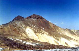 The two northern summits of Aragats volcano in NW Armenia seen from a ridge to the south. Extensive hydrothermal alteration has modified rocks in the summit region of this large andesitic-to-dacitic stratovolcano. The main edifice of Aragats is dissected by glaciers and is of Pliocene to late-Pleistocene age. Satellite cones and fissures have produced lava flows of late-Pleistocene to possible Holocene age.
Photo by Alexander Margarian.
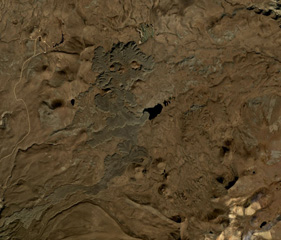 A group of scoria cones with recent lava flows of the Tskhouk-Karckar volcanic group are in the center of this October 2019 Planet Labs satellite image monthly mosaic (N is at the top; this image is approximately 16 km across). The longest flow to the south traveled around 9 km from the vent. The lavas have abundant lobate flow edges and pressure ridges, and overlap older cones and flows.
Satellite image courtesy of Planet Labs Inc., 2018 (https://www.planet.com/).
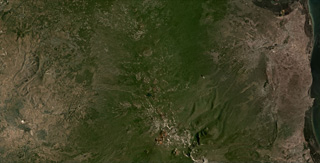 The Ghegam Volcanic Ridge can be seen through the center of this July 2020 Planet Labs satellite image monthly mosaic (N is at the top; this image is approximately 55 km across). Around 127 identified volcanic centers, including lava domes and cones, span an area 65 km long and 35 km wide in Armenia, west of Lake Sevan.
Satellite image courtesy of Planet Labs Inc., 2020 (https://www.planet.com/).
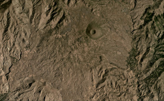 The Vaiyots-Sar scoria cone has a roughly 500-m-wide summit crater, seen in this August 2020 Planet Labs satellite image monthly mosaic (N is at the top; this image is approximately 15 km across). Lavas with visible flow boundaries and levees are to the NW and S to SW of the cone, with some long, linear flows and some much broader flow fronts with pressure ridges.
Satellite image courtesy of Planet Labs Inc., 2020 (https://www.planet.com/).
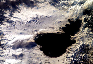 Small cones and lava domes dot the surface of snow-covered Ghegam Ridge (upper left), located west of Lake Sevan (right) in west-central Armenia. North lies to the upper right in this NASA International Space Station image. The volcanoes and associated lava flows cover a 65-km-long, 35-km-wide area west of Lake Sevan and are concentrated along three NNW-SSE-trending alignments. Lava flows from the central and eastern clusters flowed into Lake Sevan at the upper left-hand side of the lake.
NASA International Space Station image ISS006-E-42481, 2003 (http://eol.jsc.nasa.gov/).
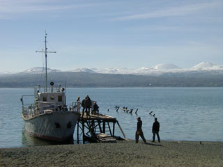 The snow-capped cones of the Ghegam Ridge volcanic field rise across Lake Sevan from a fishing village on its NE shore. This volcanic field in west-central Armenia covers a 35-km-wide area between the capital city of Yerevan and Lake Sevan. Morphologically youthful lava flows from the central and eastern portions of Ghegam Ridge flowed into Lake Sevan.
Photo by Ivan Savov, 2002 (Smithsonian Institution).
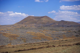 A lava flow extends across the foreground from a cone within the Porak volcanic field, located along the Vardeniss volcanic ridge about 20 km SE of Lake Sevan. The volcanic field straddles the Armenia/Azerbaijan border, and lava flows extend into both countries. This lava flow is the youngest of the volcanic field. Another flow from the same cone (located in Armenia) flowed into Lake Alagyol in Azerbaijan. Archaeological and historical evidence indicates several eruptions occurred during the Holocene.
Photo by Jim Luhr, 2004 (Smithsonian Institution).
This is a compilation of Armenia volcano information sources, such as official monitoring or other government agencies.
| Volcanic Ash Advisory Center | |
|---|---|
| Toulouse Volcanic Ash Advisory Center (VAAC) Notices and Archive | |