Rwanda Volcanoes
Rwanda has 1 Holocene volcanoes. Note that as a scientific organization we provide these listings for informational purposes only, with no international legal or policy implications. Volcanoes will be included on this list if they are within the boundaries of a country, on a shared boundary or area, in a remote territory, or within a maritime Exclusive Economic Zone. Bolded volcanoes have erupted within the past 20 years. Suggestions and data updates are always welcome ().
| Volcano Name | Last Eruption | Volcanic Region | Primary Landform |
|---|---|---|---|
| Karisimbi | 8050 BCE | Albertine Rift Volcanic Province | Composite |
Chronological listing of known Holocene eruptions (confirmed or uncertain) from volcanoes in Rwanda. Bolded eruptions indicate continuing activity.
| Volcano Name | Start Date | Stop Date | Certainty | VEI | Evidence |
|---|---|---|---|---|---|
| Karisimbi | 8050 BCE (?) | Unknown | Confirmed | Isotopic: K/Ar |
Rwanda has 6 Pleistocene volcanoes. Note that as a scientific organization we provide these listings for informational purposes only, with no international legal or policy implications. Volcanoes will be included on this list if they are within the boundaries of a country, on a shared boundary or area, in a remote territory, or within a maritime Exclusive Economic Zone. Suggestions and data updates are always welcome ().
| Volcano Name | Volcanic Region | Primary Landform |
|---|---|---|
| Central Virunga Volcanic Field | Albertine Rift Volcanic Province | Cluster |
| Gahinga | Albertine Rift Volcanic Province | Composite |
| Muhavura | Albertine Rift Volcanic Province | Composite |
| Sabinyo | Albertine Rift Volcanic Province | Composite |
| Southern Virunga Volcanic Field | Albertine Rift Volcanic Province | Cluster |
| Visoke | Albertine Rift Volcanic Province | Composite |
There are 7 photos available for volcanoes in Rwanda.
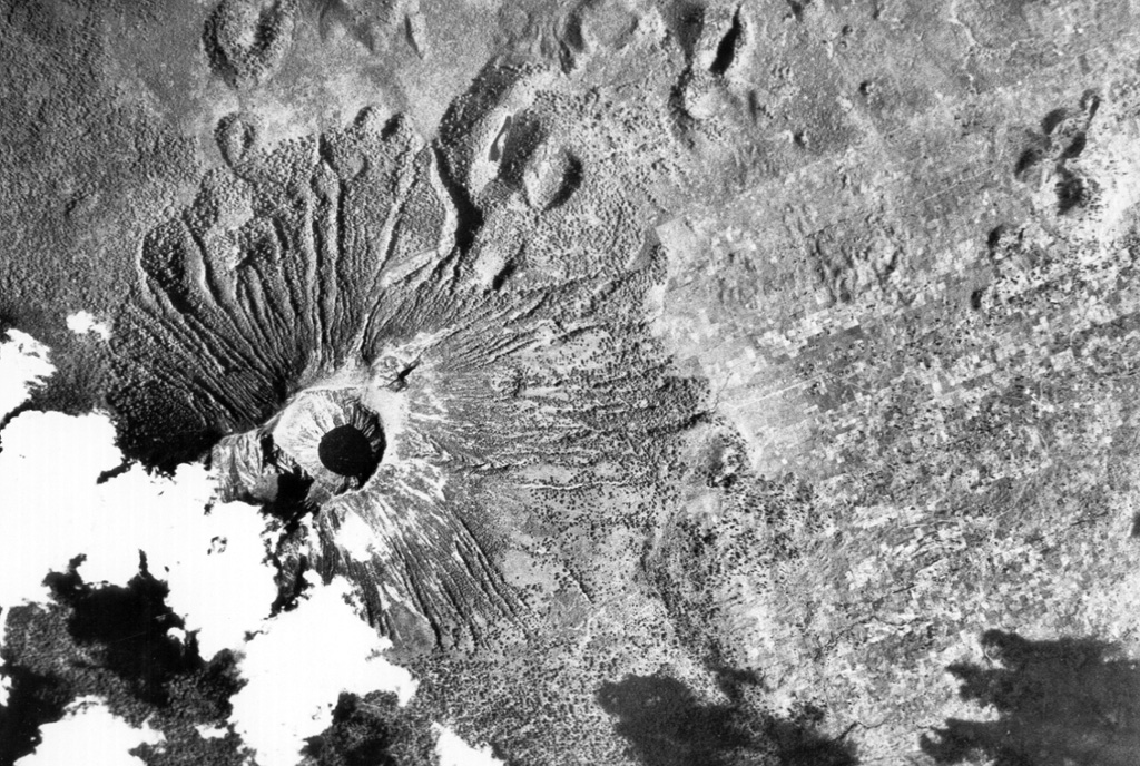
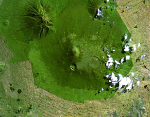
 Visoke volcano is the NE-most of a cluster of large stratovolcanoes at the southern end of the Virunga Range. The volcano contains a 450-m-wide lake in its summit crater (left center). Lobate lava flows descend the flanks of the volcano. A NE-SW-trending fissure zone has produced many scoria cones NE of the volcano (top). An eruption in 1957 formed two small cones on the north flank, 11 km from the summit.
Aerial photograph courtesy of Henry Luc Hody (Belgian ambassador).
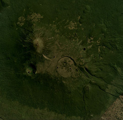
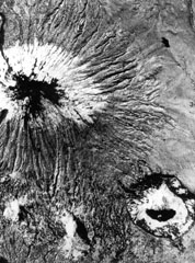 This aerial photo, with N to the upper left, shows Karisimbi (upper left) and the large 1.2-km-wide Muntango crater (lower right) located S of the summit; the 2-km-wide Branca caldera is located out of view to the right. The recent eruptions from Karisimbi produced a group of vents E of the caldera, which fed lava flows to the east, and the SW-flank lava vents.
Aerial photograph courtesy of Henry Luc Hody (Belgian ambassador).
 Mikeno volcano (center) and Karisimbi volcano (right) are seen here from the E on the flanks of Nyamuragira volcano. Mikeno is an eroded Pleistocene volcano; Karisimbi is younger. The 2-km-wide Branca caldera is located SE of the summit of Karisimbi and is filled by viscous lava flows and has two craters. More than 100 parasitic cones extend along a NNE-SSW zone to the shores of Lake Kivu.
Photo by Henry-Luc Hody, 1989.
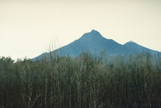
 The forested Muhavura volcano (center) rises at the NE end of the Virunga Range. The Gahinga (Mgahinga) volcano, the smaller cone at left-center, is joined to Muhavura on the west by a broad saddle. Muhavura is stratovolcano with a small crater that has been recently active, but the age of its latest eruption is not known.
NASA Landsat image, 1999 (courtesy of Hawaii Synergy Project, Univ. of Hawaii Institute of Geophysics & Planetology).
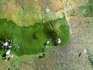
 Muhavura is at the NE end of the Virunga volcanic range and is seen here in an August 2019 Planet Labs satellite image mosaic (N at the top). The summit is E of the image center, and W of that is the Gahinga flank cone. To the far W is the flank of Sabinyo.
Satellite image courtesy of Planet Labs Inc., 2019 (https://www.planet.com/).
 This June 2018 Planet Labs satellite image mosaic (N at the top) shows Karisimbi volcano of the Virunga volcanic field in Rwanda. The 1.5-km-wide Caldera Branca is seen near the center, with the summit to the NW and Mutango crater south of that. Extending SE of the caldera is a lava flow field with individual flows reaching 12 km in length.
Satellite image courtesy of Planet Labs Inc., 2018 (https://www.planet.com/).
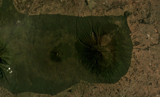
 The Karisimbi volcanic complex (center) includes a symmetrical, peaked summit flanked to the SE by the 2-km-wide Branca caldera, which is filled by viscous lava flows and two craters. The smaller Muntango crater is located S of the summit. A broad lava plain composed of flows erupted within the caldera and along a chain of parasitic cones, extends SW. Eroded Mikeno volcano is at the upper left and Visoke volcano at the upper right of this Landsat image.
NASA Landsat image, 1999 (courtesy of Hawaii Synergy Project, Univ. of Hawaii Institute of Geophysics & Planetology).
This is a compilation of Rwanda volcano information sources, such as official monitoring or other government agencies.
| Volcanic Ash Advisory Center |
|---|
| Toulouse Volcanic Ash Advisory Center (VAAC) Notices and Archive |