OVSICORI-UNA reported that at 0749 on 17 July a brief ash emission from Turrialba rose 200 m above the crater and drifted SW. Minor amounts of ash fell in Irazú Volcano National Park.
Source: Observatorio Vulcanologico y Sismologico de Costa Rica-Universidad Nacional (OVSICORI-UNA)
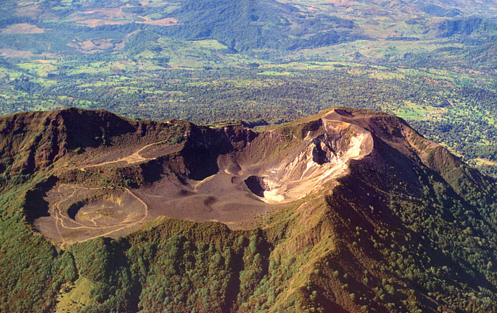
Small phreatic eruption on 17 July 2022
Activity began to subside at Turrialba after 2019, following a period of weak ash explosions and emissions, allowing for the reappearance of a hydrothermal system. Thereafter, occasional weak explosions at this Costa Rican stratovolcano were thought to be phreatic (steam-driven), with associated minor passive ash emissions (BGVN 46:09, 47:04). The following report summarizes activity from March-August 2022 and is based primarily on information from periodic reports published by the Observatorio Vulcanologico Sismologica de Costa Rica-Universidad Nacional (OVSICORI-UNA) and satellite data.
Overall activity was at a low level during this reporting period. Occasional small rumblings were recorded, some associated with minor ash emissions. Seismicity remained low, eventually returning to the pre-June 2021 level, and geodetic monitoring showed that the Irazú-Turrialba massif continued to subside and contract, especially around the active Turrialba crater.
In early April 2022 an inspection of the bottom of the West Crater (or Bat Crater) with a drone revealed some fumaroles, mainly in the eastern sector, releasing steam and sulfur gases. The fumaroles registered temperatures of at least 113°C according to remote measurement with an infrared thermograph.
According to OVSICORI-UNA, at 0749 on 17 July a brief phreatic eruption was recorded. An ash emission rose less than 500 m above the crater and drifted SW, with minor ashfall in Irazú Volcano National Park. This was the only eruption during the reporting period, and the first since 27 February 2022. Seismic activity continued to decrease.
A sulfur dioxide plume was detected originating from Turrialba on 30 August, using the TROPOMI instrument on the Sentinel-5P satellite. According to OVSICORI-UNA, the plume contained 108 tons of SO2.
Information Contacts: Observatorio Vulcanologico Sismologica de Costa Rica-Universidad Nacional (OVSICORI-UNA), Apartado 86-3000, Heredia, Costa Rica (URL: http://www.ovsicori.una.ac.cr/); NASA Global Sulfur Dioxide Monitoring Page, Atmospheric Chemistry and Dynamics Laboratory, NASA Goddard Space Flight Center (NASA/GSFC), 8800 Greenbelt Road, Goddard MD, USA (URL: https://so2.gsfc.nasa.gov/).
2022: January
| February
| July
2021: June
| July
| November
| December
2020: June
| July
| August
2019: January
| February
| March
| April
| May
| July
2018: January
| February
| March
| April
| May
| July
| August
| September
| October
| November
| December
2017: January
| February
| March
| April
| May
| June
| July
| August
| September
| October
| November
2016: January
| February
| March
| April
| May
| June
| July
| September
| October
| November
| December
2015: March
| April
| May
| October
2014: October
| November
| December
2013: May
| July
2012: January
| February
2011: January
| June
2010: January
| March
| May
| July
| August
2009: June
| September
| December
2008: January
| September
| October
2007: May
| August
| September
| December
2006: September
| October
OVSICORI-UNA reported that at 0749 on 17 July a brief ash emission from Turrialba rose 200 m above the crater and drifted SW. Minor amounts of ash fell in Irazú Volcano National Park.
Source: Observatorio Vulcanologico y Sismologico de Costa Rica-Universidad Nacional (OVSICORI-UNA)
OVSICORI-UNA reported that a point of incandescence on the SW wall of Turrialba’s Cráter Oeste was visible on 23 February and was coincident with the area of strongest gas emissions. At 1955 on 27 February an eruption produced a diffuse ash plume that rose 300 m above the summit and drifted NE. Rumbling heard on 28 February was sometimes coincident with minor ash emissions.
Source: Observatorio Vulcanologico y Sismologico de Costa Rica-Universidad Nacional (OVSICORI-UNA)
OVSICORI-UNA reported that at 0412 on 19 February an eruption at Turrialba’s Cráter Oeste produced a small ash plume that rose 100 m above the summit and drifted W. Minor ashfall was reported by park rangers in Parque Nacional Volcán Irazú. An eruptive event was recorded later that day at 1624, though weather clouds prevented visual confirmation.
Source: Observatorio Vulcanologico y Sismologico de Costa Rica-Universidad Nacional (OVSICORI-UNA)
OVSICORI-UNA reported that at 1259 on 6 February a small phreatic eruption at Turrialba’s Cráter Oeste produced an ash plume that rose 100 m above the crater rim. A thermal anomaly from the floor of Cráter Oeste was identified in satellite images on 4 February. The anomaly was last seen in the same location on 25 January, and twice in 2021, during clear weather conditions; the location of the anomaly was the same in those images since March 2021, and likely represented a hot crack venting on the crater floor. Two incandescent points in the crater were visible in overnight webcam images during 7-8 February.
Source: Observatorio Vulcanologico y Sismologico de Costa Rica-Universidad Nacional (OVSICORI-UNA)
OVSICORI-UNA reported that three areas of incandescence in Turrialba’s Cráter Oeste were visible during 26-27 January.
Source: Observatorio Vulcanologico y Sismologico de Costa Rica-Universidad Nacional (OVSICORI-UNA)
OVSICORI-UNA reported that periodic eruptive events, lasting 1-2 minutes each, were recorded at Turrialba’s West Crater during 19-24 January. At 0546 on 19 January an eruption produced an ash plume that rose 200 m above the summit and drifted W. A small eruption at 1052 generated a plume that rose 50 m and drifted NW. At 0706 on 24 January an event generated a plume that rose 100 m and drifted SW. Two points of incandescence on the internal SW crater wall were also visible.
Source: Observatorio Vulcanologico y Sismologico de Costa Rica-Universidad Nacional (OVSICORI-UNA)
OVSICORI-UNA reported that incandescence from Turrialba’s West Crater was visible overnight during 15-16 January. Eruptive events were recorded at 2126 and 2132 on 17 January; the second event was stronger and produced an ash-and-gas plume that rose 1 km above the crater. Ashfall and a sulfur odor were reported by residents in Coronado, Tres Rios (30 km SW), Alajuela (50 km W), and Santa Ana (46 km WSW). At 1115 on 18 January an eruptive event produced a plume that rose 300 m and drifted SW.
Source: Observatorio Vulcanologico y Sismologico de Costa Rica-Universidad Nacional (OVSICORI-UNA)
OVSICORI-UNA reported that an area of incandescence on the NW inner wall of Turrialba’s West Crater had been periodically visible at least since mid-November, and was visible during 26-27 December, suggesting that fumarolic temperatures exceeded 300 degrees Celsius. At 0644 on 28 December a one-minute-long eruption produced an ash emission that rose 50 m above the crater rim and drifted W. Another small eruption that produced ash emissions was recorded at 1105 by the seismicity and infrasound networks. The event was heard by authorities in the Parque Nacional Volcán Turrialba.
Source: Observatorio Vulcanologico y Sismologico de Costa Rica-Universidad Nacional (OVSICORI-UNA)
OVSICORI-UNA reported that at 0624 on 23 November a one-minute-long eruption at Turrialba produced a plume that rose 500 m above the crater rim and drifted SW. Another small eruption was recorded on 7 November.
Source: Observatorio Vulcanologico y Sismologico de Costa Rica-Universidad Nacional (OVSICORI-UNA)
OVSICORI-UNA reported that on 11 November a small area of incandescence was visible on the internal SW wall of Turrialba’s summit vent. Vigorous degassing from the vent was recorded.
Source: Observatorio Vulcanologico y Sismologico de Costa Rica-Universidad Nacional (OVSICORI-UNA)
OVSICORI-UNA reported that a one-minute-long eruption at Turrialba was recorded at 0646 on 3 November and produced a plume that rose 200 m above the crater rim and drifted W. Another small eruption was recorded on 7 November.
Source: Observatorio Vulcanologico y Sismologico de Costa Rica-Universidad Nacional (OVSICORI-UNA)
OVSICORI-UNA reported that a one-minute-long eruption at Turrialba was recorded at 1130 on 23 July, though weather clouds prevented visual confirmation of an eruption plume. Ash fell in areas 3.5 km W.
Source: Observatorio Vulcanologico y Sismologico de Costa Rica-Universidad Nacional (OVSICORI-UNA)
OVSICORI-UNA reported that an eruption at Turrialba at 1800 on 13 June produced an ash plume that rose 300 m above the crater and drifted SW. Residents in several areas reported volcanic gas odors and rumbling, and minor ashfall was reported in Monte Calas and La Central.
Source: Observatorio Vulcanologico y Sismologico de Costa Rica-Universidad Nacional (OVSICORI-UNA)
On 21 August OVSICORI-UNA reported that fracturing of SW wall of Turrialba’s active crater, along with an area of incandescence within the fracture zone, had been observed during the previous month. An eruption was recorded at 1253 on 22 August, though a plume was not visible due to weather conditions. At 2301 on 24 August a plume rose 1 km above the crater rim.
Source: Observatorio Vulcanologico y Sismologico de Costa Rica-Universidad Nacional (OVSICORI-UNA)
OVSICORI-UNA reported that there were 19 minor ash emissions recorded at Turrialba during 4-5 August, with event durations lasting no longer than three minutes and plumes rising no higher than 200 m above the summit. Four more events were recorded on 5 August, with event durations lasting less than 10 minutes. Plumes again rose no higher than 200 m.
Source: Observatorio Vulcanologico y Sismologico de Costa Rica-Universidad Nacional (OVSICORI-UNA)
At 0946 on 29 July an eruptive event generated a plume that rose 200-300 m above Turrialba’s crater rim. Several ash eruptions (10) were recorded for a period starting at 2010 on 30 July and ending at 0940 on 31 July. Each event lasted less than 10 minutes and plumes rose no higher than 200 m. An incandescent area was visible on the SW wall of the crater. At 0746 on 1 August a plume rose 500 m and at 0545 on 4 August a plume rose 300 m.
Source: Observatorio Vulcanologico y Sismologico de Costa Rica-Universidad Nacional (OVSICORI-UNA)
OVSICORI-UNA reported that during 22-23 July white steam plumes from Turrialba contained a minor amount of ash on one occasion.
Source: Observatorio Vulcanologico y Sismologico de Costa Rica-Universidad Nacional (OVSICORI-UNA)
OVSICORI-UNA reported that ash emissions of variable densities were visible at Turrialba almost daily during 16-20 July. Ash plumes rose as high as 200 m above the crater rim each day during 16-18 July.
Source: Observatorio Vulcanologico y Sismologico de Costa Rica-Universidad Nacional (OVSICORI-UNA)
OVSICORI-UNA reported that passive emissions with minor amounts of ash were occasionally visible at Turrialba during 9-10 July.
Source: Observatorio Vulcanologico y Sismologico de Costa Rica-Universidad Nacional (OVSICORI-UNA)
OVSICORI-UNA reported that small ash emissions rose to low heights above the active crater at Turrialba almost daily during 1-7 July; no emissions were recorded on 3 July. A plume of gas and ash rose hundreds of meters at 0900 on 6 July, causing local ashfall.
Source: Observatorio Vulcanologico y Sismologico de Costa Rica-Universidad Nacional (OVSICORI-UNA)
OVSICORI-UNA reported that occasional small ash emissions rose no higher than 100 m above the active crater at Turrialba each day during 23-29 June; no emissions were recorded on 27 June. A series of ash emissions were recorded at 1348, 1739, and 2303 on 28 June and at 0107, 0232, 0306, 0412, and 0818 on 28 June. At least two of those events (0107 and 0412) were accompanied by ballistics that were ejected onto the N wall of the active crater.
Source: Observatorio Vulcanologico y Sismologico de Costa Rica-Universidad Nacional (OVSICORI-UNA)
OVSICORI-UNA reported that ash emissions at Turrialba rose no higher than100 m above the crater rim from events recorded at 1714, 1723, and 1818 on 18 June and at 1023 and 1039 on 19 June. A small ash emission was visible at 1715 on 22 June.
Source: Observatorio Vulcanologico y Sismologico de Costa Rica-Universidad Nacional (OVSICORI-UNA)
OVSICORI-UNA reported that an eruptive event at Turrialba was detected at 1441 on 28 July, though inclement weather conditions prevented visual confirmation. Ashfall was reported in La Picada (N) and El Retiro farms.
Source: Observatorio Vulcanologico y Sismologico de Costa Rica-Universidad Nacional (OVSICORI-UNA)
On 19 May OVSICORI-UNA reported that passive, short-duration emissions with small amounts of ash had been sporadically occurring at Turrialba over the previous week. Prolonged and intermittent periods of emissions with minor amounts of ash were visible during 19-20 May.
Source: Observatorio Vulcanologico y Sismologico de Costa Rica-Universidad Nacional (OVSICORI-UNA)
OVSICORI-UNA reported that a diffuse ash emission rose from Turrialba on 24 April, and an emission with low ash content drifted N on 26 April. At 0722 on 27 April a small, short-duration eruption generated an ash plume that rose less than 100 m above the crater rim.
Source: Observatorio Vulcanologico y Sismologico de Costa Rica-Universidad Nacional (OVSICORI-UNA)
OVSICORI-UNA reported that minor ash emissions rose from Turrialba on 8 April.
Source: Observatorio Vulcanologico y Sismologico de Costa Rica-Universidad Nacional (OVSICORI-UNA)
OVSICORI-UNA reported that gas emissions at Turrialba significantly decreased on 30 March. An eruption recorded at 0735 on 31 March was followed by passive emissions with a low concentration of magmatic gases at least through 1 April. Seismicity continued to be dominated by low-frequency events.
Source: Observatorio Vulcanologico y Sismologico de Costa Rica-Universidad Nacional (OVSICORI-UNA)
OVSICORI-UNA reported a period of continuous emissions from Turrialba during 20-22 March. The emissions were characterized as white water vapor plumes with periodic pulses of diffuse ash rising 300 m above the vent rim and drifting W and SW. A sulfur odor was noted in Tierra Blanca de Cartago on 22 March. Only water vapor plumes with a low concentration of magmatic gases were visible during 23-26 March.
Source: Observatorio Vulcanologico y Sismologico de Costa Rica-Universidad Nacional (OVSICORI-UNA)
OVSICORI-UNA reported that during 9-12 March plumes of gas sometimes containing small amounts of ash rose as high as 1 km above Turrialba’s crater rim.
Source: Observatorio Vulcanologico y Sismologico de Costa Rica-Universidad Nacional (OVSICORI-UNA)
OVSICORI-UNA reported that an event at Turrialba at 1050 on 28 February generated a plume that rose 500 m above the crater rim and drifted SW. Some additional ash pulses were recorded that day. An event at 0444 on 1 March produced a plume that rose 200 m and drifted NE. A period of continuous emissions rising 200-300 m was recorded during 2-4 March; the plumes contained minor amounts of ash at least during 2-3 March.
Source: Observatorio Vulcanologico y Sismologico de Costa Rica-Universidad Nacional (OVSICORI-UNA)
OVSICORI-UNA reported that an event at Turrialba on 21 February generated a plume that rose 300 m and drifted NW. Frequent ash pulses were recorded that day. Ash emissions were frequent during 22-24 February, though of variable intensity and duration. Plumes rose as high as 300 m and drifted NW and SW. On 22 February ashfall was reported in Santa Cruz (31 km WSW) and Santa Ana, and a sulfur odor was evident in Moravia (31 km WSW). Cloudy weather conditions prevented visual observations of the vent during 25-26 February.
Source: Observatorio Vulcanologico y Sismologico de Costa Rica-Universidad Nacional (OVSICORI-UNA)
OVSICORI-UNA reported that during 13-15 February a period of almost continuous gas emissions with minor ash content rose 200-300 m above the rim of Turrialba’s active vent. The plumes drifted NW, W, and SW. An event at 1330 on 15 February produced a plume that rose 1 km and drifted W. During the morning of 18 February a plume with low ash content rose from the vent. An event at 1310 generated a plume that rose 500 m and drifted W.
Source: Observatorio Vulcanologico y Sismologico de Costa Rica-Universidad Nacional (OVSICORI-UNA)
OVSICORI-UNA reported that a period of sporadic ash emissions from Turrialba began at 0540 on 8 February and lasted more than one hour. The activity produced ash plumes that rose no more than 200 m above the vent rim. A very small ash emission was visible on 11 February.
Source: Observatorio Vulcanologico y Sismologico de Costa Rica-Universidad Nacional (OVSICORI-UNA)
OVSICORI-UNA reported that minor, sporadic ash emissions that rose to low heights above Turrialba’s active crater were recorded on most days during 28 January-4 February. An event at 0640 on 1 February produced a taller plume which rose 1.5 km above the crater rim and drifted NW.
OVSICORI-UNA noted that activity had been slowly decreasing in 2019. No volcano-tectonic earthquakes had been recorded, and tremors were decreasing in both energy and duration. The number of low-frequency, volcanic earthquakes (LPs) remained stable, although they had decreasing amplitudes. No explosions had been recorded, and emissions were weak, had short durations, and very dilute ash contents.
Source: Observatorio Vulcanologico y Sismologico de Costa Rica-Universidad Nacional (OVSICORI-UNA)
OVSICORI-UNA reported semi-continuous activity at Turrialba during 11-16 December. Ash emissions rose as high as 500 m above the vent rim and drifted NW and SW during 11-12 December. Ashfall was reported in Guadalupe (32 km WSW) on 13 December. Pulsing ash emissions were visible on 13 December and caused ashfall in areas of Valle Central. During 14-16 December emissions had diffuse amounts of ash and drifted W and SW.
Source: Observatorio Vulcanologico y Sismologico de Costa Rica-Universidad Nacional (OVSICORI-UNA)
OVSICORI-UNA reported continuing activity at Turrialba during 5-11 December. A minor emission from the vent was visible on 5 December, and an ash emission drifted S the next day. An event at 0749 on 8 December produced an ash plume that rose 500 m and drifted NW. Emissions of ash, steam, and gas rose as high as 1 km on 9 December and caused ashfall in areas of Valle Central. On 10 December diffuse emissions were periodically observed during periods of clear viewing. That same day ash fell in Moravia (31 km WSW) and Santa Ana, and residents of Heredia (38 km W) noted a sulfur odor.
Source: Observatorio Vulcanologico y Sismologico de Costa Rica-Universidad Nacional (OVSICORI-UNA)
OVSICORI-UNA reported intermittent pulses of ash and some periods of continuous ash emissions from Turrialba during 28 November-3 December. Ash plumes rose as high as 500 m above the crater rim and drifted N, NW, and SW. Ashfall was reported in Santo Domingo (36 km WSW) on 2 December.
Source: Observatorio Vulcanologico y Sismologico de Costa Rica-Universidad Nacional (OVSICORI-UNA)
OVSICORI-UNA reported that at 0710 on 22 November an event at Turrialba generated an ash plume that rose 100 m above the crater rim and drifted W. The next day there were frequent pulses of ash. During 23-25 November occasional Strombolian explosions ejected lava bombs that were deposited near the crater; residents of Cascajal de Coronado reported hearing several booming sounds. Ash plumes rose as high as 500 m. During 26-27 November passive emissions with small quantities of ash were visible. Minor ashfall was reported in San Jose (Cascajal de Coronado and Dulce Nombre), San Pedro Montes de Oca, and neighborhoods of Heredia.
Source: Observatorio Vulcanologico y Sismologico de Costa Rica-Universidad Nacional (OVSICORI-UNA)
OVSICORI-UNA reported that periodic, passive ash emissions at Turrialba continued to be visible in webcam images or during cloudy conditions inferred from the seismic data during 13-19 November.
Source: Observatorio Vulcanologico y Sismologico de Costa Rica-Universidad Nacional (OVSICORI-UNA)
OVSICORI-UNA reported that during 6-11 November low-level ash-and-gas emissions at Turrialba were continuous, though occasionally punctuated by energetic explosions which elevated the plumes as high as 500 m above the crater rim. The emission drifted towards the Valle Central. Ashfall was reported in several areas downwind including Cascajal de Coronado, Desamparados (35 km WSW), San Antonio, Guadalupe (32 km WSW), Sabanilla, San Pedro Montes de Oca, Moravia (31 km WSW), Heredia (38 km W), and Coronado (San José, 35 km WSW). Emissions likely continued on 12 November, though inclement weather did not allow for visual confirmation.
Source: Observatorio Vulcanologico y Sismologico de Costa Rica-Universidad Nacional (OVSICORI-UNA)
On 1 November OVSICORI-UNA reported that since 24 October emissions at Turrialba were continuous with plumes rising 500 m above the crater rim. In addition, seismicity was characterized by banded volcanic tremor, long-period earthquakes, and low-amplitude volcano-tectonic earthquakes. Passive ash emissions were visible during 1-6 November. A 70-minute-long event began at 0530 and generated plumes that rose 500 m and drifted SW. Several short-duration (2-3 minutes) events were recorded at 1523 and 1703 on 2 November and at 0109 on 3 November; they generated ash plumes that rose 500 m. Ashfall was reported in Coronado. Seismic activity remained high, with moderate-to-high amplitude banded tremor. At 0620 on 5 November a plume rose 600 m and drifted NW.
Source: Observatorio Vulcanologico y Sismologico de Costa Rica-Universidad Nacional (OVSICORI-UNA)
OVSICORI-UNA reported that when weather conditions allowed for observations gas and periodic ash emissions rising from Turrialba were recorded by the webcam during 25-30 October. An event at 0134 on 26 October produced an ash plume that rose 500 m above the crater rim and drifted NE, causing ashfall in the neighborhoods of Coronado (San José, 35 km WSW) and San Isidro de Heredia (Heredia, 38 km W). Events at 0231 on 29 October and 1406 on 30 October produced plumes that rose 500 m and drifted NW and W respectively.
Source: Observatorio Vulcanologico y Sismologico de Costa Rica-Universidad Nacional (OVSICORI-UNA)
OVSICORI-UNA reported frequent Strombolian events at Turrialba since 5 October. Periodic gas-and-ash emissions rose 200-500 m above the crater rim and drifted E, NW, and SW during 17-23 October.
Source: Observatorio Vulcanologico y Sismologico de Costa Rica-Universidad Nacional (OVSICORI-UNA)
OVSICORI-UNA reported that most days during 10-16 October intermittent, passive gas-and-ash emissions at Turrialba rose as high as 1 km above the crater rim. The emissions drifted W, SW, S, and NE. There were also some explosive events; an energetic explosion was recorded at 1712 on 14 October, though cloudy weather prevented estimates of a plume height.
Source: Observatorio Vulcanologico y Sismologico de Costa Rica-Universidad Nacional (OVSICORI-UNA)
OVSICORI-UNA reported that intense crater incandescence was visible at Turrialba the night of 3 October. At 0800 on 8 October an event produced an ash plume that rose 500 m above the crater and drifted N.
Source: Observatorio Vulcanologico y Sismologico de Costa Rica-Universidad Nacional (OVSICORI-UNA)
OVSICORI-UNA reported that at 0915 on 27 September an event at Turrialba produced a passive ash plume that rose 200 m above the crater and drifted NW. During 30 September-1 October ash emissions rose as high as 500 m above the crater rim and drifted NW and NE.
Source: Observatorio Vulcanologico y Sismologico de Costa Rica-Universidad Nacional (OVSICORI-UNA)
OVSICORI-UNA reported that passive gas-and-ash emissions from Turrialba were continuous in September through the 13th. Events during 17-18 September produced plumes that rose 300 m above the crater and drifted SW and NW.
Source: Observatorio Vulcanologico y Sismologico de Costa Rica-Universidad Nacional (OVSICORI-UNA)
OVSICORI-UNA reported that passive gas-and-ash emissions from Turrialba were continuous during 27 August-5 September, with plumes rising 100 m above the vent. Emissions on 6 September were mostly gas, punctuated by small and sporadic ash plumes. At 1210 on 10 September an event produced an ash plume that rose 300 m above the crater rim and drifted NW.
Source: Observatorio Vulcanologico y Sismologico de Costa Rica-Universidad Nacional (OVSICORI-UNA)
OVSICORI-UNA reported that at 1340 on 30 August an event at Turrialba produced an ash plume that passively rose 200 m above the crater rim and drifted SW. Gas-and-ash emissions became continuous during 31 August-1 September, with plumes rising 200 m and drifting SW and W.
Source: Observatorio Vulcanologico y Sismologico de Costa Rica-Universidad Nacional (OVSICORI-UNA)
OVSICORI-UNA reported that during 27-28 August emissions from Turrialba rose continuously to 200 m above the crater rim, and drifted SW.
Source: Observatorio Vulcanologico y Sismologico de Costa Rica-Universidad Nacional (OVSICORI-UNA)
OVSICORI-UNA reported that pulsating, passive ash emissions rising from Turrialba and drifting W were visible during periods of clear weather on 10 August. The next day a strong sulfur odor was reported in parts of Heredia (38 km W) and San José (36 km WSW).
Source: Observatorio Vulcanologico y Sismologico de Costa Rica-Universidad Nacional (OVSICORI-UNA)
OVSICORI-UNA reported that during 2-4 August activity at Turrialba was characterized by sporadic, passive gas-and-ash emissions. Events at 0023 and 0700 on 2 August generated diffuse ash plumes that rose 1 km and 300 m, respectively, and drifted W. An event at 1600 on 4 August produced a diffuse ash plume that rose 300 m.
Source: Observatorio Vulcanologico y Sismologico de Costa Rica-Universidad Nacional (OVSICORI-UNA)
OVSICORI-UNA reported that during 23-31 July activity at Turrialba was characterized by sporadic, passive gas-and-ash emissions detected almost daily. The plumes rose no higher than 300 m above the vent rim, and drifted NW, W, and SW. Ashfall was reported in several neighborhoods in the Valle Central, including Coronado, Tibás (35 km WSW), Goicoechea (28 km WSW), and Moravia (31 km WSW) on 24 July, and in Tres Ríos (27 km SW) on 31 July. A sulfur odor was occasionally reported.
Source: Observatorio Vulcanologico y Sismologico de Costa Rica-Universidad Nacional (OVSICORI-UNA)
OVSICORI-UNA reported increased activity at Turrialba during 23-24 July characterized by small sporadic emissions. A very low and diffuse ash plume rose from the crater on 24 July, causing ashfall in Coronado, Tibás (35 km WSW), Goicoechea (28 km WSW), Moravia (31 km WSW), and other areas in the Valle Central.
Source: Observatorio Vulcanologico y Sismologico de Costa Rica-Universidad Nacional (OVSICORI-UNA)
OVSICORI-UNA reported that an event at Turrialba at 0930 on 28 May generated a plume that rose 300 m above the crater rim and drifted SE.
Source: Observatorio Vulcanologico y Sismologico de Costa Rica-Universidad Nacional (OVSICORI-UNA)
OVSICORI-UNA reported that an event at Turrialba at 0900 on 21 May generated a plume that rose to an unknown height due to poor visibility.
Source: Observatorio Vulcanologico y Sismologico de Costa Rica-Universidad Nacional (OVSICORI-UNA)
OVSICORI reported that there were strong emissions of SO2 from Turrialba, accompanied by vigorous fumarolic activity and jetting noises. An ash plume was reported on 10 May, with ashfall in La Pastora de Santa Cruz de Turrialba and Pacayas. A weak water vapor and gas plume was detected at 0920 on 13 May, rising 300-500 m (1000-1600 ft) above the summit. Seismicity was low, with low-amplitude long-period earthquakes and some low-amplitude tremor. Continuous low-amplitude tremor was report on 13 May.
Source: Observatorio Vulcanologico y Sismologico de Costa Rica-Universidad Nacional (OVSICORI-UNA)
OVSICORI-UNA reported that an event at Turrialba at 0700 on 26 April generated a small ash plume that rose 300 m above the crater rim and drifted W.
Source: Observatorio Vulcanologico y Sismologico de Costa Rica-Universidad Nacional (OVSICORI-UNA)
The Washington VAAC reported that on 11 April an ash emission from Turrialba were seen through an OVSICORI-UNA web camera.
Source: Washington Volcanic Ash Advisory Center (VAAC)
OVSICORI-UNA reported that events at Turrialba at 1230 on 5 April and 0609 on 9 April generated plumes that rose 500 and 300 m above the crater rim, and drifted S and W, respectively.
Source: Observatorio Vulcanologico y Sismologico de Costa Rica-Universidad Nacional (OVSICORI-UNA)
OVSICORI-UNA reported that events at Turrialba at 1802 on 31 March and 0838 on 1 April generated plumes that rose 400 and 500 m above the crater rim, and drifted SW and NW, respectively. An event at 0700 on 3 April produced an ash plume that rose 500 m and went NW; passive ash emissions followed.
Source: Observatorio Vulcanologico y Sismologico de Costa Rica-Universidad Nacional (OVSICORI-UNA)
OVSICORI-UNA reported that an event at Turrialba at 0605 on 23 March generated a small ash plume that rose 100 m above the crater rim and drifted SW.
Source: Observatorio Vulcanologico y Sismologico de Costa Rica-Universidad Nacional (OVSICORI-UNA)
RSN and OVSICORI-UNA reported that a new eruptive phase at Turrialba began at 2240 on 6 March with minor ash emissions that rose 500 m above the vent rim and drifted NW. The activity intensified around midnight, with dense ash emissions and the ejection of incandescent blocks, and remained elevated almost until 0300 on 7 March. At 1740 activity again intensified; emissions with an increased volume of ash was recorded by the webcam from 1801-1820 drifting W. OVSICORI-UNA reported that events at 1515 on 8 March and 0920 on 13 March generated ash plumes that rose 300 m and drifted SW and NW, respectively.
Sources: Observatorio Vulcanologico y Sismologico de Costa Rica-Universidad Nacional (OVSICORI-UNA); Red Sismologica Nacional (RSN: UCR-ICE), Universidad de Costa Rica and Instituto Costarricense de Electricidad
OVSICORI-UNA reported that an event at Turrialba at 0800 on 27 February generated a plume that rose 100 m above the crater rim and drifted SW.
Source: Observatorio Vulcanologico y Sismologico de Costa Rica-Universidad Nacional (OVSICORI-UNA)
OVSICORI-UNA reported that an event at Turrialba at 0830 on 5 February generated a plume that rose 200 m above the crater rim and drifted SW. An event at 0730 on 6 February generated an ash plume that rose 1 km and drifted SW. Ashfall was reported in Goicoechea and Heredia.
Source: Observatorio Vulcanologico y Sismologico de Costa Rica-Universidad Nacional (OVSICORI-UNA)
OVSICORI-UNA reported that events at Turrialba at 1101 and 1427 on 26 January and at 0920 on 30 January generated plumes that rose 100-200 m above the crater rim and drifted SW.
Source: Observatorio Vulcanologico y Sismologico de Costa Rica-Universidad Nacional (OVSICORI-UNA)
OVSICORI-UNA reported that an event at Turrialba at 0000 on 22 January generated a plume that rose 500 m above the crater rim and drifted NW.
Source: Observatorio Vulcanologico y Sismologico de Costa Rica-Universidad Nacional (OVSICORI-UNA)
OVSICORI-UNA reported that an event at Turrialba at 0400 on 15 January generated a plume of unknown height due to weather conditions. Ashfall was reported in areas N of Pacayas (Pinos, Buenos Aires, and Santa Rosa de Oreamuno) and a sulfur odor was noted in Santa Rosa de Oreamuno.
Source: Observatorio Vulcanologico y Sismologico de Costa Rica-Universidad Nacional (OVSICORI-UNA)
OVSICORI-UNA reported that events at Turrialba at 0600 and 1319 on 8 January generated ash emissions that rose 400-500 m above the crater rim and drifted NW and NE, respectively. An event at 2005 generated an ash plume that rose 800 m above the crater rim and drifted SW. At 0630 on 9 January an ash plume rose 300 m above the crater rim and drifted SW. An event was recorded at 1412, though weather conditions prevented visual conformation.
Source: Observatorio Vulcanologico y Sismologico de Costa Rica-Universidad Nacional (OVSICORI-UNA)
OVSICORI-UNA reported that a small event at Turrialba at 1319 on 1 December generated a weak ash plume that rose 50 m above the crater rim and drifted SW.
Source: Observatorio Vulcanologico y Sismologico de Costa Rica-Universidad Nacional (OVSICORI-UNA)
OVSICORI-UNA reported that an ash emission at Turrialba began before 0730 on 13 November and intensified around 0830. An ash plume rose 500 m above the crater rim and drifted SW.
Source: Observatorio Vulcanologico y Sismologico de Costa Rica-Universidad Nacional (OVSICORI-UNA)
The Washington VAAC reported that an ash emission from Turrialba was observed in webcam images on 4 November. Ash was not identified in satellite images, though weather cloud cover was increasing and may have obscured views.
Source: Washington Volcanic Ash Advisory Center (VAAC)
OVSICORI-UNA reported that events at Turrialba at 1030, 1105, and 1445 on 30 October generated ash plumes that rose 200-500 m above the crater rim and drifted NW, W, and SW. Ashfall was reported in the community of Pacayas (about 12 km SSW). OVSICORI-UNA noted that the ash emissions from the event at 1445 rose from the reddish crater.
Source: Observatorio Vulcanologico y Sismologico de Costa Rica-Universidad Nacional (OVSICORI-UNA)
OVSICORI-UNA reported that an event at Turrialba at 0825 on 20 October generated an ash plume that rose 300 m above the crater rim and drifted NW.
Source: Observatorio Vulcanologico y Sismologico de Costa Rica-Universidad Nacional (OVSICORI-UNA)
OVSICORI-UNA reported that an event at Turrialba at 0927 on 11 October generated an ash plume that rose 200 m above the crater rim and drifted N.
Source: Observatorio Vulcanologico y Sismologico de Costa Rica-Universidad Nacional (OVSICORI-UNA)
OVSICORI-UNA reported that an event at Turrialba at 0815 on 6 October produced a plume that rose 50 m above the crater rim and drifted NW. An event at 1040 on 9 October generated a plume that rose 200 m and drifted NW.
Source: Observatorio Vulcanologico y Sismologico de Costa Rica-Universidad Nacional (OVSICORI-UNA)
OVSICORI-UNA reported that daily events at Turrialba during 27 September-1 October and on 3 October generated plumes that rose as high as 1 km above the crater rim and drifted NW, W, SW, and S. On 30 September explosions ejected hot material out of West Crater and minor ashfall was reported in Coronado (San José). Ash fell in Santa Cruz (7 km SE), Las Verbenas, Santa Teresita, Calle Vargas, Guayabito, and La Isabel on 3 October.
Source: Observatorio Vulcanologico y Sismologico de Costa Rica-Universidad Nacional (OVSICORI-UNA)
OVSICORI-UNA reported that events at Turrialba at 1112 on 25 September and 0910 on 26 September generated plumes that rose 300 m above the crater rim and drifted NW.
Source: Observatorio Vulcanologico y Sismologico de Costa Rica-Universidad Nacional (OVSICORI-UNA)
OVSICORI-UNA reported that events at Turrialba at 1555 on 13 September and 0600 on 14 September generated plumes that rose 300 m above the crater rim and drifted NW and W. Another event at 0703 on 18 September produced a plume that rose 400 m.
Source: Observatorio Vulcanologico y Sismologico de Costa Rica-Universidad Nacional (OVSICORI-UNA)
OVSICORI-UNA reported that an event at Turrialba at 0730 on 11 September generated a plume that rose 500 m above the crater rim and drifted N. Another event at 0820 on 13 September passively produced an ash plume that rose 100 m and drifted NW.
Source: Observatorio Vulcanologico y Sismologico de Costa Rica-Universidad Nacional (OVSICORI-UNA)
OVSICORI-UNA reported that an event at Turrialba at 0820 on 5 September generated a plume that rose 400 m above the crater rim and drifted NW. Another event at 1550 that same day produced a plume that rose 500 m and drifted SW.
Source: Observatorio Vulcanologico y Sismologico de Costa Rica-Universidad Nacional (OVSICORI-UNA)
OVSICORI-UNA reported that an event at Turrialba at 0715 on 24 August generated a plume that rose 400 m above the crater rim and drifted NW. Another event at 1025 on 28 August produced a plume that rose 300 m and drifted NW.
Source: Observatorio Vulcanologico y Sismologico de Costa Rica-Universidad Nacional (OVSICORI-UNA)
OVSICORI-UNA reported that an event at Turrialba at 1012 on 21 August generated a plume that rose 200 m above the crater rim and drifted NW.
Source: Observatorio Vulcanologico y Sismologico de Costa Rica-Universidad Nacional (OVSICORI-UNA)
OVSICORI-UNA reported that an event at Turrialba at 1607 on 9 August generated a plume that rose 200 m above the crater rim and drifted NW. The report noted that since 6 August a monitoring station in Coronado San José had been detecting the presence of ash in emissions. Sporadic and passive emissions of ash, water vapor, magmatic gases, and aerosols continued to be observed at least through 14 August.
Source: Observatorio Vulcanologico y Sismologico de Costa Rica-Universidad Nacional (OVSICORI-UNA)
OVSICORI-UNA reported that on 26 July an event at Turrialba passively produced a plume that rose 300 m above the crater and drifted SW.
Source: Observatorio Vulcanologico y Sismologico de Costa Rica-Universidad Nacional (OVSICORI-UNA)
OVSICORI-UNA reported that during 19-24 July plumes of water vapor, aerosols, and magmatic gases rose as high as 500 m above Turrialba’s crater rim, and on most nights incandescence emanated from Cráter Oeste. The emissions contained ash during 20-22 July. Minor ashfall was reported in Coronado (San José) on 20 July, and in Sabanilla de Montes de Oca (30 km WSW) on 22 July.
Source: Observatorio Vulcanologico y Sismologico de Costa Rica-Universidad Nacional (OVSICORI-UNA)
OVSICORI-UNA reported eruptive events at Turrialba daily during 12-17 July. Gas and ash plumes rose 200-500 m above the vent and generally drifted NW, W, and SW. There were multiple events on 15 July, causing ashfall in Sabanilla de Montes de Oca (30 km WSW), Ipis (27 km SW), El Carmen de Guadalupe, Purral (26 km WSW), Guadalupe (32 km WSW), and Tibás (35 km WSW). A sulfur dioxide odor was also reported that day, in San José (36 km WSW), Tibas (35 km WSW), Guadalupe, Escazú (42 km WSW), and Puriscal (65 km WSW).
Source: Observatorio Vulcanologico y Sismologico de Costa Rica-Universidad Nacional (OVSICORI-UNA)
OVSICORI-UNA reported that during 4-11 July plumes of water vapor, aerosols, and magmatic gases rose as high as 500 m above Turrialba’s crater rim, and on most nights incandescence emanated from Cráter Oeste. The emissions sporadically contained moderate amounts of ash during 5-7 July. Minor ashfall was reported in Coronado (San José), and in San Rafael and Barva (Heredia). Parque Nacional Volcán Turrialba staff reported that ash was deposited in the region between La Silvia and La Picada farms. Events at 1325 on 10 July and 1545 on 11 July generated plumes that rose 300 and 500 m above the crater rim, respectively.
Source: Observatorio Vulcanologico y Sismologico de Costa Rica-Universidad Nacional (OVSICORI-UNA)
OVSICORI-UNA reported that during 29 June-4 July seismicity at Turrialba was characterized by low-to-medium amplitude tremor, and a small number of low-amplitude volcano-tectonic and long-period events. Plumes of water vapor, magmatic gases, and occasional ash rose as high as 1 km above the West Crater fumaroles. Incandescence from the main crater was recorded at night. Minor ashfall and a sulfur odor was reported in areas of San José including Rancho Redondo, Goicoechea, Moravia, San Pedro Montes de Oca, and Guadalupe.
Source: Observatorio Vulcanologico y Sismologico de Costa Rica-Universidad Nacional (OVSICORI-UNA)
OVSICORI-UNA reported that during 20-25 June seismicity at Turrialba was characterized by low-to-medium amplitude tremor, and a small number of low-amplitude volcano-tectonic and long-period events. Plumes of water vapor and magmatic gases rose as high as 1 km above the crater. The gases were strongly incandescent at night during 22-23 June.
Source: Observatorio Vulcanologico y Sismologico de Costa Rica-Universidad Nacional (OVSICORI-UNA)
OVSICORI-UNA reported that during 14-15 June gas emissions at Turrialba sometimes contained ash and rose no higher than 300 m above the crater. Events at 0620 and 1405 on 16 June generated ash plumes that rose 500 m and drifted NW, and 200 m and drifted S, respectively. Passive ash emissions during 19-20 June rose as high as 1 km and drifted in multiple directions.
Source: Observatorio Vulcanologico y Sismologico de Costa Rica-Universidad Nacional (OVSICORI-UNA)
OVSICORI-UNA reported that tremor amplitude at Turrialba fluctuated from low to medium levels during 7-13 June. Periods of small volcano-tectonic events and many small-amplitude long-period events were also recorded. Plumes of gas and water vapor rose as high as 1 km above the vent and drifted mainly NW, W, and SW.
Source: Observatorio Vulcanologico y Sismologico de Costa Rica-Universidad Nacional (OVSICORI-UNA)
OVSICORI-UNA reported that volcano-tectonic amplitude at Turrialba fluctuated from low to moderate levels during 30-31 May. Plumes of water vapor, magmatic gases, and material rose no higher than 300 m above the crater rim, sporadically contained ash, and drifted NW. On 3 June at 1930 an event produced an ash plume that rose 300 m and drifted SW. The report noted that during the previous week ash emissions had been sporadic and not generated by explosions.
Source: Observatorio Vulcanologico y Sismologico de Costa Rica-Universidad Nacional (OVSICORI-UNA)
OVSICORI-UNA reported that tremor amplitude at Turrialba fluctuated from low to high levels during 23-30 May, often corresponding to emission characteristics. Periods of volcano-tectonic and long-period events were also recorded. During 24-26 May several passive and sporadic ash emissions rose no higher than 500 m above the vent and drifted NW and SW. Frequent and small explosions during 26-27 May generated ash plumes that rose higher than 500 m above the vent, and ejected material higher than 200 m and no farther than 100 m towards Central Crater. Small explosions during 27-29 May produced ash plumes that rose 300-500 m.
Source: Observatorio Vulcanologico y Sismologico de Costa Rica-Universidad Nacional (OVSICORI-UNA)
OVSICORI-UNA reported that low-to-moderate amplitude tremor was recorded at Turrialba during 17-23 May. Small numbers of volcano-tectonic and long-period events were recorded during 18-19 May, and low-frequency and volcano-tectonic events were detected during 21-22 May. Ash emission were observed during 17-23 May, rising as high as 1 km above the vent. Ashfall was reported in El Tapojo and Juan Viñas (15 km SSE) during 17-18 May, and in Capellades (along with a strong sulfur odor) during 19-20 May.
Source: Observatorio Vulcanologico y Sismologico de Costa Rica-Universidad Nacional (OVSICORI-UNA)
OVSICORI-UNA reported an explosion at Turrialba on 10 May, followed by weak and passive ash emissions during 10-11 May. Several long-period earthquakes were recorded, and inflation continued. Gas measurements indicated a sulfur dioxide flux of 1,000 tons/day, and a high carbon dioxide/sulfur dioxide ratio. An event at 0900 on 12 May generated a plume, though poor visibility prevented a height estimate. An event at 0730 on 14 May generated a plume that rose 500 m above the crater rim and drifted N. Low-amplitude tremor was detected during 15-16 May, and a discontinuous ash plume rose no more than 500 m and drifted N and NW.
Source: Observatorio Vulcanologico y Sismologico de Costa Rica-Universidad Nacional (OVSICORI-UNA)
OVSICORI-UNA reported that an event at Turrialba at 1700 on 5 May generated a weak ash plume that rose 500 m above the crater and drifted SW. Two short-amplitude events occurred at 1702 and 1820 though there was no confirmation if they had corresponded to eruptions. During 5-7 May volcano-tectonic and long-period earthquakes were detected, as well as variable-amplitude tremor. At 1250 on 6 May an event produced a plume that rose 300 m and drifted W. Between 1250 and 1730 a passive ash emission rose no higher than 1 km. Another passive ash emission rose about 500 m at 1000 on 7 May and drifted WNW. At 0902 on 9 May an event generated an ash plume that rose 500 m and drifted NW.
Source: Observatorio Vulcanologico y Sismologico de Costa Rica-Universidad Nacional (OVSICORI-UNA)
OVSICORI-UNA reported a passive ash emission from Turrialba on 16 April. An event at 0751 on 17 April generated a plume with minor ash content that rose 500 m above the crater and drifted SW. A diffuse plume consisting of gas and sometimes ash rose 1 km above the crater and drifted W on 18 April.
Source: Observatorio Vulcanologico y Sismologico de Costa Rica-Universidad Nacional (OVSICORI-UNA)
OVSICORI-UNA reported that ash-and-gas plumes from Turrialba rose 500 m above the crater during 31 March-1 April. Ashfall was reported at the Juan Santamaría airport, 48 km W. Ash plumes rose 500 m at 1700 on 2 April, and 200 m at 0601 on 4 April.
Source: Observatorio Vulcanologico y Sismologico de Costa Rica-Universidad Nacional (OVSICORI-UNA)
OVSICORI-UNA reported that a weak ash emission from Turrialba was visible during 1800-1940 on 25 March. Periods of more intense crater incandescence, from possible Strombolian activity, corresponded to higher tremor amplitude during 0330-0530 on 26 March. Later that day a small plume with a minor amount of ash rose 500 m above the crater and drifted S and SE. An event at 0752 on 28 March generated an ash plume that rose 300 m and drifted S.
Source: Observatorio Vulcanologico y Sismologico de Costa Rica-Universidad Nacional (OVSICORI-UNA)
OVSICORI-UNA reported that during 20-21 March weak gas emissions at Turrialba contained sporadic, small amounts of ash, and rose no higher than 100 m above the crater rim and drifted SW. Volcanic tremor had medium and variable amplitude, and a few low-frequency earthquakes were recorded.
Source: Observatorio Vulcanologico y Sismologico de Costa Rica-Universidad Nacional (OVSICORI-UNA)
OVSICORI-UNA reported that during 15-16 February high-amplitude tremor at Turrialba remained constant, and sporadic gas emissions with minor amounts of ash drifted S and E. Occasional ballistics were ejected from the crater. During 16-17 February sporadic gas emissions with low ash content rose no higher than 300 m and drifted NW and SW. Tremor amplitude had decreased to moderate levels. Similar emissions were observed during 20-21 February, although they drifted NW and NE.
Source: Observatorio Vulcanologico y Sismologico de Costa Rica-Universidad Nacional (OVSICORI-UNA)
OVSICORI-UNA reported that at 1610 on 8 February an ash plume rose 300 m above Turrialba's active vent and drifted N. An event at 1531 on 10 February also produced an ash plume but inclement weather prevented estimates of the plume height. During 11-12 February variable amplitude tremor was detected, and at night hot blocks ejected from the vent landed in Cráter Central. Several events on 13 February (at 0255, 0305, 0415, and 1459) produced ash plumes that rose as high as 1 km and drifted N, NW, and W. Several small ejections of incandescent material fell around the active crater during the early morning. On 14 February continuous emissions of gas and steam with low ash content were visible. A strong sulfur odor was reported in San Pablo de Oreamuno (25 km SW).
Source: Observatorio Vulcanologico y Sismologico de Costa Rica-Universidad Nacional (OVSICORI-UNA)
On 1 February OVSICORI-UNA reported that since 27 January the seismic network at Turrialba recorded variable-amplitude, discontinuous tremor indicative of moving pressurized volcanic fluid. Passive emissions of ash were observed during 1-2 February, rising as high as 500 m above the crater. Ashfall was reported in Desamparados, Calle Blancos, and Tres Ríos, and a sulfur odor was noted in San Pablo Heredia. An eruption at 0900 on 4 February generated an ash plume that rose 300 m and drifted W. Almost continuous ash emissions rose at most 500 above the crater during 4-5 February and drifted WSW. Variable-amplitude tremor continued to be recorded.
Source: Observatorio Vulcanologico y Sismologico de Costa Rica-Universidad Nacional (OVSICORI-UNA)
Based on webcam views, the Washington VAAC reported ongoing ash emissions at Turrialba on 27 January.
Source: Washington Volcanic Ash Advisory Center (VAAC)
Based on webcam and satellite views, the Washington VAAC reported that on 22 January an ash plume from Turrialba rose to an altitude of 4 km (13,000 ft) a.s.l. and drifted E.
Source: Washington Volcanic Ash Advisory Center (VAAC)
OVSICORI-UNA reported that at 2212 on 28 December and at 0335 on 30 December events at Turrialba generated plumes of unknown height due to poor visibility conditions. An event at 0801 on 30 December produced a dense and passive emission of ash that rose 300 m above the crater and drifted SW. An event later that same day, at 2001, produced a plume that was not visible.
Source: Observatorio Vulcanologico y Sismologico de Costa Rica-Universidad Nacional (OVSICORI-UNA)
OVSICORI-UNA reported that after three days of continuous ash emissions at Turrialba activity decreased during the morning of 8 December. Weak and sporadic emissions rising no higher than 200 m above the vent were observed in the afternoon. Events at 0919 and 0934 on 9 December produced ash plumes that rose 500 m and drifted NW. Weak and sporadic ash emissions the rest of the day rose no higher than 500 m. Passive ash emissions on 12 December did not exceed 500 m and drifted NW.
Source: Observatorio Vulcanologico y Sismologico de Costa Rica-Universidad Nacional (OVSICORI-UNA)
OVSICORI-UNA reported that at 1130 on 6 December an event at Turrialba generated a diffuse ash plume that rose 400 m above the crater and drifted W.
Source: Observatorio Vulcanologico y Sismologico de Costa Rica-Universidad Nacional (OVSICORI-UNA)
OVSICORI-UNA reported that tremor and ash emissions at Turrialba ceased on 17 November. Tremor amplitude increased at 0140 on 19 November, though weather clouds prevented visual confirmation of correlating emissions. By 0800 tremor amplitude was low and some long-period events were recorded. Low emissions were mostly white, indicating gas, water vapor, and minor amounts of ash. A small quantity of ash fell in Cartago and Paraíso de Cartago (25 km SW). Tremor amplitude remained low on 20 November. A thin layer of ash deposits were reported in Ipis de Goicoechea, 27 km SW of the crater.
Source: Observatorio Vulcanologico y Sismologico de Costa Rica-Universidad Nacional (OVSICORI-UNA)
OVSICORI-UNA reported that during 9-13 November ash plumes observed almost daily rose as high as 1 km above Turrialba’s active vent. The plumes drifted in variable directions, particularly to the SW, W, and NE, and ashfall was reported in many areas of the Valle Central. Tremor decreased on 13 November; ash emissions were not observed on 14 November.
Source: Observatorio Vulcanologico y Sismologico de Costa Rica-Universidad Nacional (OVSICORI-UNA)
OVSICORI-UNA reported that daily during 27 October-1 November ash plumes rose as high as 1 km above Turrialba’s active vent. The plumes drifted in variable directions; ashfall was reported in Nubes de Coronado on 28 October.
Source: Observatorio Vulcanologico y Sismologico de Costa Rica-Universidad Nacional (OVSICORI-UNA)
OVSICORI-UNA reported that during 18-22 October continuous passive ash emissions rose from Turrialba as high as 1 km above the vent and drifted NE and W. The activity was accompanied by stable, low-to-moderate amplitude tremor with a few brief intervals of rest. Ash fell in Siquirres (30 ENE), Guacimo (23 km NNE), Guapiles (21 km N), and Moravia (27 km W). During 23-25 October emissions were discontinuous and ash content was low; plumes drifted NW and W. Ashfall was reported in San José (36 km WSW), Tibás (35 km WSW), Guadalupe (32 km WSW), Curridabat (32 km WSW), Tres Ríos (27 km SW), Moravia, San Pedro (32 km WSW), and various areas of the Valle Central.
Source: Observatorio Vulcanologico y Sismologico de Costa Rica-Universidad Nacional (OVSICORI-UNA)
OVSICORI-UNA reported that tremor levels and ash emissions at Turrialba decreased around 1700 on 11 October. A small eruption occurred at 2132; ashfall was reported in Guadeloupe. Another event was recorded at 1620 on 12 October but weather conditions obscured views of any resulting emissions. On 13 October long-period earthquakes were associated with ash emissions that rose no higher than 500 m above the vent. Tremor amplitude increased around 1029 on 13 October and remained variably elevated at least through 15 October; emissions occurred at around 1029 and 2006 on 13 October, and almost continuously during 14-15 October, producing ash plumes that rose as high as 1 km. Ashfall and a sulfur odor was reported in areas downwind, near the volcano. On 16 October OVSICORI-UNA noted that the almost constant ash emission in the previous few days affected the operation and communication of various scientific instruments installed at the top of the volcano and surrounding areas; communication with two seismic stations located near the summit was lost. Webcams showed continuing ash emissions rising as high as 1 km during 16-18 October.
Source: Observatorio Vulcanologico y Sismologico de Costa Rica-Universidad Nacional (OVSICORI-UNA)
OVSICORI-UNA reported that during 4-5 October tremor levels at Turrialba were low. At 0600 on 6 October tremor levels rose a small amount, and coincided with an emission with minor amounts of ash that rose 1 km and drifted N and NE. Tremor levels again rose at 1054, coinciding with another ash emission. Tremor amplitude varied during 7-11 October, and almost continuous ash emissions rose no more than 500 m and drifted N, NW, W, and SW. Minor ashfall and a sulfur odor were reported in some local areas downwind.
Source: Observatorio Vulcanologico y Sismologico de Costa Rica-Universidad Nacional (OVSICORI-UNA)
OVSICORI-UNA reported that continuous ash emissions of varying intensity rose from Turrialba during 26-29 September. On the morning of 30 September emissions reduced and rose passively no more than 100 m above the crater. Tremor was constant but had a low amplitude. Later that day intermittent gas, steam, and ash plumes rose as high as 500 m and drifted W and SW. Intermittent eruptions during 2-3 October produced ash plumes that rose no higher than 1 km and drifted S, SSW, SW, and NNE. Ashfall and a sulfur odor were reported in multiple areas downwind. Activity increased at 0823 on 3 October, with almost continuous emissions rising at most 1 km, and continued steadily through 4 October.
Source: Observatorio Vulcanologico y Sismologico de Costa Rica-Universidad Nacional (OVSICORI-UNA)
OVSICORI-UNA reported that during 21-22 September multiple eruptive episodes at Turrialba generated ash, gas, and steam emissions that generally rose as high as 700 m above the crater and drifted N, NW, W, and SW. Ashfall and a sulfur odor were reported in some areas of Valle Central. An energetic episode that began at 0320 on 22 September produced an ash plume that rose 2 km and drifted WSW. Another episode accompanied by tremor which began at 1345 generated an ash plume that rose 1 km. Surficial activity significantly decreased on 23 September; a few short episodes were detected but weather clouds prevented observations. Seismicity remained high, characterized by very-long-period events. Seismicity decreased on 24 September and activity was very low through the afternoon of 25 September; a few minor eruptions were detected. At 2110 on 25 September an eruption was detected seismically, but cloud cover blocked views. Ashfall and a sulfur odor was reported in Valle Central communities, including San José and Heredia. An eruption at 1225 on 26 September produced an ash plume that rose 1 km and drifted NW. Cloud cover again prevented visual observations of activity that began at 1242, and lasted for four hours. Based on the amplitude of the seismic signal, webcam images, and observations from scientists in the field, ash plumes were estimated to rise as high as 2 km. Continuous passive emissions continued to rise as high as 2 km until 1000 on 27 September; between 1000 and 1242 ash plumes rose 300-500 m.
Source: Observatorio Vulcanologico y Sismologico de Costa Rica-Universidad Nacional (OVSICORI-UNA)
OVSICORI-UNA reported that starting at 0210 on 13 September ash emissions from Turrialba rose 300 m and drifted NNW. A small explosion was detected later that day at 1947. Small explosions were detected at 1804 and 2147 on 15 September. On 16 September small explosions were recorded at 0240, followed by three periods of passive ash emissions. An explosion at 1100 on 16 September generated an ash plume that rose 50 m above the crater and likely drifted S (inclement weather prevented visual observations). Ashfall was reported in the Parque Nacional Braulio Carrillo, and areas E of San José and Heredia including Ipís de Guadalupe.
A series of gas-and-ash emissions began at 0958 on 17 September with an ash plume that rose 400 m above the crater and drifted NW. Plumes the rest of the day did not exceed that height, though an explosion at 2148 generated a plume that rose 500 m. Ash-and-gas emissions were recorded on 18 September; some plumes were observed rising as high as 500 m, although inclement weather hindered most observations. Explosions during four energetic periods on 19 September generated ash plumes that rose as high as 4 km. A sulfur odor and ashfall was reported in many communities in the Valle Central including those in San José (35 km WSW), Heredia (38 km W), Alajuela, and Cartago (25 km SW). According to news articles, flights in and out of the Juan Santamaría International Airport were canceled; the airport remained closed at least through the morning of 20 September. The Pavas San José Tobías Bolaños Airport was also temporarily closed. At night during 19-20 September ash emissions rose as high as 500 m and drifted WNW. Ash plumes during the rest of 20 September rose as high as 700 m. Plumes drifted NW and NE.
Sources: Observatorio Vulcanologico y Sismologico de Costa Rica-Universidad Nacional (OVSICORI-UNA); Stuff; Tico Times
OVSICORI-UNA reported that at 0200 on 13 September ash emissions from Turrialba rose 300 m and drifted NNW.
Source: Observatorio Vulcanologico y Sismologico de Costa Rica-Universidad Nacional (OVSICORI-UNA)
OVSICORI-UNA reported that an explosion at Turrialba recorded at 1309 on 22 July generated an ash plume that rose 800 m and drifted W. Increased tremor coincided with the event. Ash-and-gas emissions rose from the crater for approximately 15 minutes, starting at 1543. Ash emissions were recorded with the webcam at 0600 on 23 July. Tremor levels fluctuated though the day; periods of increased tremor likely corresponded to ash emissions. Visual observations of the crater were hindered by fog. Tremor amplitude increased at 1800 on 24 July. Two explosions, at 2123 and 2217, ejected hot rock fragments, gas, and ash 500 m above the crater; the gas-and-ash plume drifted SW. Gas-and-ash emissions passively rose from the crater through the next morning. At 0722 on 25 July an explosion generated an ash plumes that rose 3 km above the crater and drifted NW, W, and SW. At 0826 another explosion produced an ash plume that rose 1.5 km.
Source: Observatorio Vulcanologico y Sismologico de Costa Rica-Universidad Nacional (OVSICORI-UNA)
OVSICORI-UNA reported that at 1330 on 13 July Turrialba produced a weak ash emission that rose 100 m and drifted W.
Source: Observatorio Vulcanologico y Sismologico de Costa Rica-Universidad Nacional (OVSICORI-UNA)
OVSICORI-UNA reported that strong tremor at Turrialba started at 0658 on 7 July. An accompanying explosion produced an ash plume that rose 1 km above the crater and likely drifted WNW and WSW. Weather conditions mostly prevented views of the crater, although at 1551 a large amount of water-vapor-and-gas emissions with minor amounts of ash were observed. Ashfall was recorded in areas downwind including in neighborhoods of San José (Coronado, La Uruca, Tibás, Rancho Redondo, Guadalupe, Sabanilla, Moravia, Ipís, Sabanilla, La Guácima of Alajuela, and San Rafael de Alajuela), Heredia (38 km W), and Turrubares. Almost continuous tremor was detected through the next day; a period of increased tremor amplitude was detected during 1030-1230. Emissions of gas, water vapor, and large amounts of ash were visible with the webcam. Ash fell in many of the same areas as the day before. Tremor levels dropped at 2030, though increased again at 0030 on 9 July. Ash emissions rose no higher than 500 m above the crater around 0900 on 9 July. Ash emissions to 300 m above the crater and elevated tremor levels continued throughout the day. Ashfall was reported in Ipís de Guadalupe and San Rafael de Heredia. Tremor significantly declined at 0115 on 10 July. Views of the crater at 0600 showed emissions of water vapor and gas with minor amounts of ash. Tremor again increased on 11 July, at 0930, and a possible ash emission occurred between 1000 and 1030, although weather conditions prevented confirmation.
Source: Observatorio Vulcanologico y Sismologico de Costa Rica-Universidad Nacional (OVSICORI-UNA)
OVSICORI-UNA reported increased tremor at Turrialba that began at 2125 on 28 June, likely coinciding with a gas-and-ash emission. Another signal at 2159 also likely coincided with an ash emission. No activity was observed with the webcam, although it was dark and cloudy. Activity had significantly decreased by 0800 on 30 June. Seismicity remained low through 5 July with only a few low-frequency earthquakes detected. Gas emissions were mostly comprised of water vapor.
Source: Observatorio Vulcanologico y Sismologico de Costa Rica-Universidad Nacional (OVSICORI-UNA)
OVSICORI-UNA reported that at 2030 on 23 June tremor increased at Turrialba and continued to fluctuate through the next day. At 0544 on 24 June a short-lived (less than three minutes) emission of ash and gas rose no higher than 200 m above the crater. A small gas-and-ash plume rose from the crater at 0650. Wind directions shifted from NW to SW. Tremor disappeared at 0740 but then reappeared at 0850 and continued. Neighborhoods in San José reported ashfall and a sulfur odor. From 2005 on 24 June through 1500 on 25 June there were 14 episodes of increased tremor amplitude, accompanied by gas-and-ash emissions that rose no more than 200 m. Rocks were occasionally ejected from the crater. A few more periods of increased tremor and ash-and-gas emissions were recorded later that evening and the morning of 26 June. Several neighborhoods in San José and Heredia reported ashfall and a sulfur odor. Between 0604 and 1930 on 26 June the seismic network recorded almost continuous, variable-amplitude volcanic tremor, with frequent spikes in amplitude associated with passive gas-and-ash emissions. At around 1930 tremor amplitude decreased and ash emissions ceased. Local areas continued to report ashfall. Tremor again increased on 28 June at 2159, though the height of the associated ash emissions was not distinguishable.
Source: Observatorio Vulcanologico y Sismologico de Costa Rica-Universidad Nacional (OVSICORI-UNA)
OVSICORI-UNA reported that high-amplitude tremor at Turrialba began at 0145 on 16 June, accompanied by passive ash-and-gas emissions that rose 500 m above the crater. Tremor and emissions ceased at 0715. Emissions of ash and gas were again observed at 0805, for a brief 10-minute period, and at 1557. A vapor plume with minor amounts of ash was visible at 1700. On 19 June tremor began at 0410, along with passive ash-and-gas emissions that rose 500 m above the crater and drifted NW. Tremor significantly decreased at 0825. Tremor signals recorded at 1158 on 20 June indicated ash emissions; the wind direction was NW.
Source: Observatorio Vulcanologico y Sismologico de Costa Rica-Universidad Nacional (OVSICORI-UNA)
OVSICORI-UNA reported that activity at Turrialba remained low during 8-9 June, characterized by minor degassing, along with small, sporadic long-period and low-frequency earthquakes. On 10 June at 0830 an explosion generated an ash plume that rose 500 m above the crater. Ash emissions and a few explosions continued until the afternoon; tremor levels decreased at 1415 and ash emissions ceased at 1457. Ashfall and/or a sulfur odor was reported in multiple areas of Valle Central including San Luis, Santo Domingo, Moravia, San Francisco, and Coronado. Tremor remained low during 11-13 June, and gas emissions rose no higher than 500 m above the crater during 11-12 June (cloud cover prevented webcam views on 13 June).
Source: Observatorio Vulcanologico y Sismologico de Costa Rica-Universidad Nacional (OVSICORI-UNA)
OVSICORI-UNA reported that activity at Turrialba had declined overall since 27 May, though seismicity continued to be dominated by long-period earthquakes and small low-frequency volcanic earthquakes. A small explosion at 0516 on 1 June generated an ash plume that rose 300 m above the vent and, based on wind dispersion models, likely drifted NW. Some residents of Valle Central reported ashfall. Continuous spasmodic tremor that began at 2240 was associated with ash emissions that rose as high as 1 km and drifted N. At 0037 on 2 June an explosion was followed by high-amplitude spasmodic tremor and a dense ash-rich plume that rose 1 km and drifted NNW. Ash emissions continued; at 0520 and 0600 ash plumes rose as high as 2 km and drifted NW, N, and NE. Tremor amplitude decreased at 1240. Afternoon clouds prevented observations of ash emissions. Ashfall was reported in several neighborhoods in San José, including San Rafael de Moravia (31 km WSW), Sabana (38 km WSW), and in Limón, including Buenos Aires (17 km N), and Pococí (45 km N). During 2-3 June ash emissions were sometimes observed rising as high as 1 km and drifted N and NE. Ashfall in areas of Limón continued to be reported. Tremor amplitude began to decline at 0621 on 3 June, and then further declined to low levels at 0330 on 4 June. At dawn on 4 June plumes of water vapor and gas rose 500 m. Degassing and seismicity remained low through 7 June.
Source: Observatorio Vulcanologico y Sismologico de Costa Rica-Universidad Nacional (OVSICORI-UNA)
OVSICORI-UNA reported that a strong explosion detected at Turrialba at 2145 on 24 May generated ash plumes that rose 3.5 km above the volcano and drifted SW. The event ejected large rocks around the crater. About one hour later ashfall was reported in multiple areas, including Santa Rosa de Oreamuno, Santa Cecilia de Heredia, and San Francisco de Heredia. At 0015 on 25 May tremor amplitude increased, and at 0030 explosions ejected abundant amounts of ash and incandescent rocks. At 0812 a gas-and-ash plume rose 500 m above the active craters. Large amounts of ash (deposits 2-7 mm thick) fell in the several neighborhoods in the towns of Carthage, Heredia (38 km W), San José (70 km W), and Alajuela (49 km W). Tremor was continuous throughout the day but the amplitude had decreased by 1900. Ash emissions continued, with plumes rising 500 m above the volcano. Tremor decreased at around 0200 on 27 May; emissions likely did not contain ash, which was confirmed at dawn. Ashfall and a strong sulfur odor was reported by residents of Aquiares (11 km SSE), Santa Cruz de Turrialba (8 km SSE), and central Turrialba. Seismicity remained low during 28-31 May, and gas emissions from the crater persisted.
Source: Observatorio Vulcanologico y Sismologico de Costa Rica-Universidad Nacional (OVSICORI-UNA)
OVSICORI-UNA reported that starting at about 1800 on 17 May the seismic network at Turrialba began recording very-long-period earthquakes, followed by sustained volcanic tremor with significant amplitude that began at 2200. At 1120 on 18 May an ash plume rose 600-700 m above the summit area and drifted SW. At 1430 tremor amplitude decreased, along with the emissions. A gas-and-vapor plume with low ash content rose as high as 300 m and drifted WNW. On 19 May vigorous gas emissions were observed, alternating with ash emissions at 0600, 0938, 1111, and 1405. The plumes rose 300-700 m and drifted S, SW, W, and NW; ashfall was reported in areas of Valle Central, including in Coronado, Guadalupe, and Heredia (38 km W). Tremor increased slightly at 1550 and an ash plume rose 1 km and drifted NNW. On 20 May at 0720 a Strombolian phase began, producing an ash-and-gas plume that rose 3 km and drifted W. The eruptive column collapsed, generating pyroclastic flows that reached the nearby ranches of La Silva and La Picada, Irazu volcano, and the Cráter Central. According to a news article, some airlines have canceled or delayed flights into the Juan Santamaría International Airport (48 km W).
Gas-and-ash emissions continued during 21-22 May; plumes rose as high as 600 m above the summit. Villagers reported ashfall in areas of San José (70 km W), Cartago (25 km SW), Alajuela (49 km W), Heredia (38 km W), Puriscal (65 km WSW), and Jaco (100 km SW). During 22-23 May tremor amplitude decreased. Ash plumes rose as high as 1 km and drifted W and SW on 23 May, causing ashfall in areas downwind including Tapezco (Zarcero-Alfaro Ruíz, 70 km WNW), Guácima de Alajuela (55 km WSW), Cartago (25 km SW), Alajuela, Heredia, Barva (39 km W), Finca Lara (17 km W), Finca Laguna (23 km WNW), Grecia, and Naranjo. Seismic tremor amplitude significantly decreased on 24 May, and ash was no longer visible in the emissions. Gas-and-steam plumes rose 500 m above the volcano.
Sources: Observatorio Vulcanologico y Sismologico de Costa Rica-Universidad Nacional (OVSICORI-UNA); Tico Times
OVSICORI-UNA reported that an explosion at Turrialba at 1140 on 16 May generated gas-and-ash emissions, though the height of the plume was not determined due to fog. Wind models suggested that the ash plume rose 3 km above the crater and drifted WNW towards Valle Central. Officials on farms 2.5 km WNW reported abundant ashfall. Sustained tremor with significant and highly-variable amplitude continued to be recorded. On 17 May gas-and-steam emissions, intermittently but frequently containing ash, were recorded by the webcam. Throughout the day volcanic tremor amplitude decreased substantially, though numerous earthquakes continued to be recorded. Ash emissions gradually ended. At 1800 the seismic network began recording a large number of very-long-period earthquake, and at around 2200 volcanic tremor with significant amplitude was detected. Seismicity remained high the next morning.
Source: Observatorio Vulcanologico y Sismologico de Costa Rica-Universidad Nacional (OVSICORI-UNA)
OVSICORI-UNA reported that frequent small explosions and sustained tremor with significant and variable amplitude continued to be recorded at Turrialba during 3-5 May. Ash plumes rose 500 m above West Crater and drifted NW and SE, though larger explosions generated ash plumes that rose as high as 1 km. During 6-7 May gas-and-water-vapor plumes rose 1 km. Tremor was characterized as having short duration and a moderate amplitude; for a period between 0530 and 1700 on 7 May tremor amplitude was high but then afterwards it drastically decreased and a significant number of discrete volcanic earthquakes were recorded. Small lahars descended drainages on the upper flanks, mainly in the Río Aquiares drainage. During 0200-0900 on 8 May small, frequent ash emissions, that rose no more than 500 m, were observed coincident with the detection of spasmodic tremor. Gas emissions rose 500 m above the crater at least until noon on 10 May. The amplitude of the volcanic tremor decreased and remained low.
Source: Observatorio Vulcanologico y Sismologico de Costa Rica-Universidad Nacional (OVSICORI-UNA)
OVSICORI-UNA reported that at about 0530 on 28 April seismicity at Turrialba increased, though gas-and-steam emissions continued at normal levels. At 0300 on 30 April passive ash emissions began and rose over 500 m above West Crater. Continuous variable amplitude tremor and frequent small explosions were recorded during 30 April-1 May. At 0630 on 1 May residents in Santa Cruz de Turrialba (8 km SSE) reported hearing sounds from the volcano resembling a turbine. At the same time the seismic network recorded an increase in the amplitude of tremor, associated with an increase in gas and tephra emissions. Minor amounts of ash fell in La Central (4 km SW) and La Pastora. On 2 May frequent small explosions and sustained seismic tremor with significantly variable amplitude were recorded. Ash-and-gas emissions rose 500 m above the crater and drifted W, though periodically plumes with higher volumes of ash rose just over 1 km. Based on a news report, there were more than 200 explosions recorded during 29 April-2 May; an explosion at around 0600 on 2 May produced an ash plume that rose 2 km high. Seismic amplitude began decreasing during 0300-0700 on 3 May. Frequent explosions continued to produce ash plumes that rose as high as 1 km and drifted mainly N. Most tephra-fall occurred around West and Central craters.
Sources: Observatorio Vulcanologico y Sismologico de Costa Rica-Universidad Nacional (OVSICORI-UNA); Tico Times
OVSICORI-UNA reported that at 0859 on 3 April an explosion at Turrialba lasting less than one minute generated an ash-and-gas plume that rose about 100 m and drifted S and SW. A small amount of ash and a sulfur odor was reported in an area 2 km NW of the volcano.
Source: Observatorio Vulcanologico y Sismologico de Costa Rica-Universidad Nacional (OVSICORI-UNA)
OVSICORI-UNA reported that at 1240 on 5 February passive gas-and-ash emissions rose from Turrialba; foggy conditions prevented estimates of ash-cloud height and drift direction, although the plume likely drifted SW. Residents of La Silvia, 2 km NW, reported a sulfur odor and ashfall. For a period of 15 minutes, starting at 1350 on 6 February, passive gas-and-ash emissions rose about 500 m above West Crater and drifted NW. According to the Washington VAAC the webcam recorded gray emissions on 8 February.
Sources: Observatorio Vulcanologico y Sismologico de Costa Rica-Universidad Nacional (OVSICORI-UNA); Washington Volcanic Ash Advisory Center (VAAC)
OVSICORI-UNA reported that at 1020 on 2 February a small ash-and-gas emission from Turrialba rose about 500 m above West Crater and drifted S.
Source: Observatorio Vulcanologico y Sismologico de Costa Rica-Universidad Nacional (OVSICORI-UNA)
OVSICORI-UNA reported that ash plumes from Turrialba rose as high as 300 m and drifted WSW on 30 October.
Source: Observatorio Vulcanologico y Sismologico de Costa Rica-Universidad Nacional (OVSICORI-UNA)
OVSICORI-UNA reported that a small ash eruption at Turrialba began at 1153 on 23 October. An explosion at 1710 on 24 October produced an ash plume that rose 800 m above the crater and drifted SSW. Multiple explosive events occurred during 24-25 October; poor weather conditions sometimes prevented views of the activity. On 25 October 10-minute-long explosive events began at 0730 and 0927 and generated ash plumes that rose 1.5 km and 200 m, respectively; plumes drifted NW and W. Pyroclastic flows from collapsing ash columns were generated both times. Volcanologists conducting fieldwork on 26 October observed morphological changes at the S edge of the W crater and nearby areas due to the recent activity. They noted fresh light-colored ash and tephra deposits on the steep wall of the active crater. Three small explosions generated ash, steam, and gas emissions. Tephra was deposited as far as 400 m away in various directions from the crater.
Source: Observatorio Vulcanologico y Sismologico de Costa Rica-Universidad Nacional (OVSICORI-UNA)
OVSICORI-UNA reported that an ash emission from Turrialba occurred at 1520 on 14 May and drifted W. An eruption that started at 1018 on 18 May, and lasted for 23 minutes, generated an ash plume that rose 400 m above the crater and drifted NW. Another ash emission from a 25-minute-long eruption, which began at 1350, rose 500 m and drifted NW. At 1549 a third ash emission drifted NNW at an unknown altitude due to cloudy conditions.
Source: Observatorio Vulcanologico y Sismologico de Costa Rica-Universidad Nacional (OVSICORI-UNA)
OVSICORI-UNA reported that a 4-minute-long ash emission from Turrialba occurred at 1004 on 6 May. The ash plume rose vertically about 600 m above the crater. Another ash emission occurred at 1245 on 11 May, and tremor was detected. No direct observations of ash were possible due to inclement weather.
Source: Observatorio Vulcanologico y Sismologico de Costa Rica-Universidad Nacional (OVSICORI-UNA)
OVSICORI-UNA reported that a 4-minute-long ash emission from Turrialba occurred at 0836 on 1 May. The ash plume rose about 500 m above the crater and drifted SW. Ash emissions that began at 1524 on 4 May lasted 23 minutes, and produced an ash plume that rose 2.5 km and drifted SW. The eruption ejected ballistics 1 km from the crater. Most of the ashfall occurred around the crater. Reports of minor ashfall and sulfur odors came from San José (Moravia, Coronado, Mata de Plátano, La Uruca, Guadalupe, Tibás, Calle Blancos, San Pedro Montes de Oca, Sabanilla Montes de Oca, Pavas, Zapote, Escazú, S of San José, Paso Ancho, Curridabat, Santa Ana), and a few localities in the eastern region of Heredia. On 5 May intermittent emissions of gas and ash rose 500 m; inclement weather prevented satellite observations.
Source: Observatorio Vulcanologico y Sismologico de Costa Rica-Universidad Nacional (OVSICORI-UNA)
Based on webcam views, and observers at the Tobías Bolaños and Juan Santamaría international airports, the Washington VAAC reported that gas emissions with minor ash content rose from Turrialba and drifted W during 23-24 April.
Source: Washington Volcanic Ash Advisory Center (VAAC)
The Washington VAAC reported that ash emissions from Turrialba were visible in the webcam on 20 April; weather clouds prevented ash detected in satellite images. Images later that day showed steam plumes with minor ash content.
Source: Washington Volcanic Ash Advisory Center (VAAC)
OVSICORI-UNA reported that at 1307 on 3 April a small ash eruption occurred at Turrialba, causing ashfall in nearby areas including Silvia and La Central (2 km SW). At 1124 on 5 April an eruption generated an ash plume that rose 500 m and caused ashfall in Curridabat (31 km WSW), Granadilla (29 km WSW), San Pedro, Desamparados (35 km WSW), Aserrí (40 km SW), San Sebastián (37 km WSW), and Escazú (42 km WSW). Gas-and-vapor plumes rose from the crater at 0800 on 6 April.
Source: Observatorio Vulcanologico y Sismologico de Costa Rica-Universidad Nacional (OVSICORI-UNA)
OVSICORI-UNA reported that on 18 March gas, vapor, and ash plumes rose from Turrialba's Cráter Oeste and seismicity remained high. Observers in Finca La Central (2 km SW) noted gas-and-steam emissions. On 19 March at 0806 and 1007 gas and water vapor emissions rose from the crater; the emissions at 1007 rose from Cráter Central and contained a small amount of ash. At 1400 the webcam recorded strong emissions of gas, vapor, and tephra from Cráter Oeste. A national park official heard two booming sounds at 1530. At around 1000 on 23 March a gas, vapor, and ash plume rose from Cráter Oeste, causing ashfall in areas E and SE of the crater including Cráter Central and el Mirador. In addition a dense and vigorous gas-and-vapor plume caused Parque Nacional Volcán Turrialba authorities to recommend masks for protection against gas inhalation.
Source: Observatorio Vulcanologico y Sismologico de Costa Rica-Universidad Nacional (OVSICORI-UNA)
Based on webcam views, weather models, and OVSICORI-UNA updates, the Washington VAAC reported that on 8 March diffuse ash emissions rose from Turrialba's West Crater and seismicity increased. OVSICORI-UNA reported an ash emission at 0100 on 11 March. Another ash emission occurred at 1050 on 12 March. Almost continuous ash emissions were observed in the afternoon and were punctuated by two noticeable explosions at 1338 and 1450. Ash plumes rose as high as 2 km above the crater and drifted NW. Ashfall occurred in the Central Valley and in the capital of San Jose (30 km WSW), and caused the closure of the Juan Santamaria International Airport, 48 km W, which reopened during the evening on 13 March. The local Tobias Bolanos airport (40 km WSW) closed intermittently. On 13 March two short explosions occurred at 1045 and 1100, and then a third occurred at 2100. According to the VAAC, ash plumes that day drifted 45 km NE at an altitude of 9.1 km (30,000) a.s.l. and drifted over 35 km W at an altitude of 6.1 km (20,000 ft) a.s.l.
Sources: Observatorio Vulcanologico y Sismologico de Costa Rica-Universidad Nacional (OVSICORI-UNA); Washington Volcanic Ash Advisory Center (VAAC); Comisión Nacional de Prevención de Riesgos y Atención de Emergencias (CNE)
OVSICORI-UNA reported that at 2128 on 8 December a strong Strombolian explosion at Turrialba lasted about 10 minutes and had no precursory activity. Ashfall (1 cm thick) and ballistics were deposited as far as 300 m W. Trace amounts of ashfall were reported in the Central Valley and in towns to the W and SW.
Source: Observatorio Vulcanologico y Sismologico de Costa Rica-Universidad Nacional (OVSICORI-UNA)
OVSICORI-UNA reported an explosion from Turrialba that started at 1926 on 13 November which lasted about 10 minutes. Another explosion occurred at 1342 on 14 November and lasted about 15 minutes, although the strongest part was 7 minutes long. National park officials reported ashfall at the top of Irazú. Volcanologists observed the 14 November explosion and collected samples at Hacienda La Central, 3 km SE of West Crater.
Source: Observatorio Vulcanologico y Sismologico de Costa Rica-Universidad Nacional (OVSICORI-UNA)
On 7 November OVSICORI-UNA reported that seismic activity at Turrialba had decreased overall during the previous few days. A seismic signal indicating a strong emission started at 2320 on 6 November and lasted about 50 minutes.
Source: Observatorio Vulcanologico y Sismologico de Costa Rica-Universidad Nacional (OVSICORI-UNA)
OVSICORI-UNA reported that seismic activity at Turrialba had started to increase in late September, and then in mid-October a three-day swarm of volcano-tectonic earthquakes was recorded. The largest event, a M 2.8, occurred at 2035 on 16 October at a depth of 5 km beneath the active crater. Magmatic degassing intensified during 28-29 October; sulfur dioxide flux was 2,000 tons per day, higher than the 1,300 tons per day average measured in September and the highest so far during 2014. During the morning of 29 October a seismologist noted a tremor signal which increased in amplitude during the afternoon and evening. An observer at a lodge noted that the gas plume was darker than usual with some ash. At 2310 a small phreatomagmatic eruption from the West Crater lasted about 25 minutes and ended with a strong explosion heard by nearby villagers. An ash cloud rose to an altitude of 5.8 km (19,000 ft) a.s.l. and drifted WSW. Ash fell in San Gerardo de Irazú, San Ramón de Tres Ríos, Coronado, Moravia, Curridabat, Desamparados, Aserrí, Escazú, Santa Ana, Belén, Guácima de Alajuela, Río Segundo de Alajuela, San Pedro Montes de Oca, Guadalupe, areas of Heredia, and the capital of San José (70 km W). The eruption destroyed the wall between the West and Central craters, depositing material around the Central Crater and partially burying it. According to a news report 11 people from Santa Cruz de Turrialba were evacuated to shelters and the national park was closed. Some schools were also temporarily closed, affecting over 300 area students.
The eruption continued during 30-31 October; analyses of collected tephra showed that the proportion of juvenile material increased its volume from 3-5% on 30 October to 7-10% the next day. Magma had not previously reached the surface at Turrialba since an eruption in 1866.
An explosion at 0520 on 1 November generated an ash plume that drifted towards the E and N parts of the Central Valley. A 3 November report stated that during the previous 24 hours seismicity had decreased significantly and no explosions were detected; seismicity remained elevated as compared to levels detected prior to the current activity. An online tool that allowed residents to note if they had observed ashfall during 31 October-4 November showed a dispersion pattern in the Central Valley W and NW of Turrialba.
Sources: Observatorio Vulcanologico y Sismologico de Costa Rica-Universidad Nacional (OVSICORI-UNA); Agence France-Presse (AFP); La Nacion; Washington Volcanic Ash Advisory Center (VAAC)
OVSICORI-UNA reported significant seismic activity at Turrialba starting on 14 July. Low-frequency signals indicating fluid movement grew from an average of less than 200 events per day to over 600 events on 14 July, reaching a peak of activity with over 1,000 events on 15 July. Low-frequency tremor was detected during 18-19 July. Elevated seismicity remained at least through the report posting on 20 July. No morphological changes at the surface were observed.
Source: Observatorio Vulcanologico y Sismologico de Costa Rica-Universidad Nacional (OVSICORI-UNA)
OVSICORI-UNA reported that on 29 May a pilot flying past Turrialba about 40 km away observed a blackish plume. Officials from the Parque Nacional Volcán Turrialba observed a gas plume that was slightly darker than usual between 0730 and 0745; seismic records showed no abnormal activity at those times or during the previous 48 hours. In addition, web camera images showed no noticeable ash emissions since 23 May. Gas plumes over 750 degrees Celsius were emitted from Boca 2010 (on the W wall) and Boca 2012 (on the E wall). The plume from Boca 2010 was whiter than the plume emitted from Boca 2012, mainly due to the difference in the ratio of magmatic gases and aerosols, and no ash.
On 4 June slight ashfall was reported in Pacayas and San Pablo in Oreamuno de Cartago (25 km SW). An observer in the National Park noted that between 1400 and 1500 gas emissions were slightly stronger and also grayish.
Source: Observatorio Vulcanologico y Sismologico de Costa Rica-Universidad Nacional (OVSICORI-UNA)
OVSICORI-UNA reported that an eruption from Turrialba's West Crater on 21 May was preceded by seismic activity characterized by more than 150 volcanic earthquakes per day since 18 April.
Increased gas emissions were detected on 20 May, producing a sky-blue plume visible from nearby areas. Hybrid earthquakes also increased and became numerous at 0452 on 21 May. Continuous harmonic tremor followed and then increased at 0720. Eruptions from West Crater occurred at 0830 and after 1100 from two vents which opened in January 2010 (Boca 2010, on the W wall) and January 2012 (Boca 2012, on the E wall). The eruptions generated ash plumes that rose more than 500 m; ashfall was reported in the area of Picada (N), and in San José (35 km WSW) and Heredia (38 km W) of Ipís de Guadalupe, Goicoechea (28 km WSW), la Fazio, Zetillal (43 km W), San Isidro-San Pedro de Coronado, and San Luis de Santo Domingo (28 km W). At around 1200 ash emissions ceased and seismicity decreased.
Source: Observatorio Vulcanologico y Sismologico de Costa Rica-Universidad Nacional (OVSICORI-UNA)
OVSICORI-UNA reported that while conducting field work at Turrialba during 2-3 February, scientists observed incandescence with temperatures between 600-700 degrees Celsius from the three main vents of the W crater. The vents are comprised of the 2010 vent (on the SW rim), the 2011 vent (on the N side at the bottom of the crater), and the 2012 vent (on the SE flank).
Source: Observatorio Vulcanologico y Sismologico de Costa Rica-Universidad Nacional (OVSICORI-UNA)
OVSICORI-UNA reported that on 12 January a new vent opened on the SE flank of the W crater of Turrialba and ash emissions drifted NNE; ashfall was reported in Tres Ríos (27 km SW). During the evening of 18 January scientists observed gas emissions and ejection of tephra from the vent. They also observed reddish flames from combusting gas, estimated to be about 700 degrees Celsius. Residents reported a dark ash cloud and ashfall in La Central (4 km SW). An OVSICORI-UNA pilot observed an ash plume that rose to altitudes of 4.3-6.1 km (14,000-20,000 ft) a.s.l. on 18 January.
Source: Observatorio Vulcanologico y Sismologico de Costa Rica-Universidad Nacional (OVSICORI-UNA)
OVSICORI-UNA reported that on 11 January local people around Turrialba heard several instances of rumbling. On 12 January an eruption occurred from a fissure on the SE flank of the main crater, in an area called La Quemada. An ash plume rose 500 m above the crater and drifted NNW, rising to an altitude of 4 km (13,000 ft) a.s.l. Later that day residents reported: a dark plume from La Quemada and a white vapor plume that rose from the fumarolic vent formed in the main crater on 5 January 2010.
According to a news article, the Turriabla National Park closed on 12 January and the National Emergency Commission (CNE) raised the Alert Level from Green to Yellow in the communities of La Central (34 km SW), Santa Cruz (7 km SE), and around the perimeter of the crater. Towns of Jiménez (21 km N), Oreamuno (45 km SW), Alvarado (38 km SW), and Cartago (25 km SW) remained at Alert Level Green.
Sources: Observatorio Vulcanologico y Sismologico de Costa Rica-Universidad Nacional (OVSICORI-UNA); La Nacion
OVSICORI-UNA reported that on 9 June scientists conducting fieldwork at Turrialba observed a new crater lake in the W crater, which opened in January 2010 and was the center of the most recent activity. Since February, rock landslides along with abundant mud and clay had accumulated in the bottom of the crater, blocking the vent. Meteoric water from rains starting in May had formed a light-green-colored lake that was 70 by 70 m and about 1 m deep. Minor bubbling in the SW and NE shores was noted, and steam and sulfur dioxide gas emissions rose from many fumarolic vents around the crater.
Source: Observatorio Vulcanologico y Sismologico de Costa Rica-Universidad Nacional (OVSICORI-UNA)
According to news articles, people near Turrialba reported minor ashfall 2 km SE, rumbling noises, and a strong sulfur odor on 14 January. A few people were evacuated. OVSICORI-UNA noted that a blue and white gas plume rose from Turrialba the next day.
Sources: Observatorio Vulcanologico y Sismologico de Costa Rica-Universidad Nacional (OVSICORI-UNA); La Nacion
The Washington VAAC reported that on 15 August ash emissions from Turrialba were seen through an OVSICORI-UNA web camera, about 600 m E of the active crater. Satellite imagery showed an approximately 10-km-wide ash plume drifting 15 km W.
Source: Washington Volcanic Ash Advisory Center (VAAC)
Based on web camera views of Turrialba, the Washington VAAC reported that on 24 July a plume of steam, gas, and ash drifted W. Over the next three hours the plume became more diffuse and steam-rich.
Source: Washington Volcanic Ash Advisory Center (VAAC)
OVSICORI-UNA reported that during April a majority of the gases emitted from Turrialba originated from the vent that opened in January, producing plumes that rose 2 km. Gas was emitted from other areas including from fissures SW of the W crater and from multiple vents and fissures in the main crater. Gas plumes mainly drifted NW, W, and SW, coincident with areas that had the most vegetation impact from the plumes.
Source: Observatorio Vulcanologico y Sismologico de Costa Rica-Universidad Nacional (OVSICORI-UNA)
OVSICORI-UNA reported that scientists visited Turrialba at night on 7 March. A gas plume, commonly seen drifting with prevailing winds, was seen that night rising 1.5 km above the crater and drifting NW. Noises from the crater were described as sounding like a jet engine and rumblings. A vent, formed in January, emitted gas at temperatures between 300 and 320 degrees Celsius. Small blocks 3-12 cm in diameter and different colors dominated the surface around the vent. Lithics ejected 30-50 m away from the vent measured 170 degrees Celsius. Incandescence seen at night originated from the vent which ejected reddish-colored tephra.
Source: Observatorio Vulcanologico y Sismologico de Costa Rica-Universidad Nacional (OVSICORI-UNA)
Based on multiple METAR weather notices during the previous few days, the Washington VAAC reported on 16 January that gas plumes containing some ash rose from Turrialba. Ash was not seen in satellite imagery that day or the next.
Source: Washington Volcanic Ash Advisory Center (VAAC)
OVSICORI-UNA reported that a phreatic eruption from Turrialba that began on 5 January was preceded by a day of increased seismicity and about 30 minutes of almost constant tremor. Two events detected about 15 minutes apart were followed by reports of ashfall as far away as 30 km. Field observations on 6 January revealed that two small vents had opened and joined together on the SE inner wall of the SW crater. Gas emission temperatures were more than 350 degrees Celsius. On 8 January seismic activity and gas emissions decreased. Observations the next day revealed that the combined vent was about 25 m wide and 80 m long. Around 60 people had evacuated from nearby farms.
Source: Observatorio Vulcanologico y Sismologico de Costa Rica-Universidad Nacional (OVSICORI-UNA)
On 5 January, OVSICORI-UNA reported that an eruption from Turrialba produced ashfall in local areas, particularly in areas to the SW, including near Irazú volcano (11 km SW). According to news articles, about 20 people evacuated the area.
Sources: Observatorio Vulcanologico y Sismologico de Costa Rica-Universidad Nacional (OVSICORI-UNA); Reuters
On 25 September, scientists from OVSICORI-UNA reported results from three field trips to Turrialba to inspect new fissures and to assess the impact of gases on surrounding areas. Winds carrying toxic gases 10 km SW, to the S side of Irazú volcano, caused trees to exhibit mild burns to a greater degree than effects from the previous year. Vegetation within a 4-km-radius on the W, NW, and E flanks was also burned more severely that previously noted. Several elongated fissures in the rim S of the W crater were documented, as well as 1 km down slope NW of the crater. One E-W-trending crack that was first seen several months before had opened up as much as 12 cm, and emitted gas and vapor at 90 degrees Celsius. On the NW lower flanks, at least three radial fissures emitted high gas-and-vapor plumes. Some fissures near the summit were 5-10 cm wide. The last of the remaining settlers in the affected areas had moved away due to the intensification and impact of the gases.
Source: Observatorio Vulcanologico y Sismologico de Costa Rica-Universidad Nacional (OVSICORI-UNA)
On 14 June, OVSICORI-UNA reported that fumarolic activity from Turrialba had been observed all around the upper flanks of the active W crater. During the previous two months, the fumarolic activity was accompanied by widening of radial cracks (1.5 cm on average), 1-2 km tall gas-and-vapor plumes, and one sustained discrete seismic swarm. Temperatures of fumarolic vents in the lower parts of the crater were between 120 and 160 degrees Celsius. The temperature of summit cracks was 94 degrees Celsius. Dairy pastures and forests had been burned as far away as 3.5 km NW and W.
Source: Observatorio Vulcanologico y Sismologico de Costa Rica-Universidad Nacional (OVSICORI-UNA)
According to news articles, access to Turrialba Volcano National Park was closed on 30 September because the S and SE winds, typical for the time of year, were blowing toxic gases to the area of the park where visitors enter and view the volcano.
Source: La Nacion
OVSICORI-UNA reported that fieldwork on 23 September revealed severely impacted vegetation on Turrialba's flanks and inner caldera in areas only mildly affected during the previous three years of sustained degassing. Vegetation in the S and SE summit areas was severely burned and infrastructure was impacted during August and September. Along the flank, S of the W crater, plants were burned down to the soil. Trees in lower-altitude areas were yellowed and seared due to extreme acidification. Pastures and areas along canyons and depressions were also affected. OVSICORI-UNA recommended that precautions should be taken when carrying out activities in the affected areas.
Source: Observatorio Vulcanologico y Sismologico de Costa Rica-Universidad Nacional (OVSICORI-UNA)
OVSICORI-UNA reported that fumarolic activity and gas discharge in and to the W of Turrialba's central crater continued throughout August. Multiple fumaroles and sulfur deposition were noted in both the central and W craters. Fumarolic emissions on the S and SE flanks of the W crater continued to damage vegetation in that area.
Source: Observatorio Vulcanologico y Sismologico de Costa Rica-Universidad Nacional (OVSICORI-UNA)
OVSICORI-UNA reported that fumarolic activity and gas discharge in and to the W of Turrialba's central crater continued throughout December. Some fumaroles were 278 degrees C and exhibited sulfur sublimate deposition. Fumarolic plumes were visible from many kilometers away. Gases were emitted from cracks on the S external wall and burned vegetation was noted. Vegetation on the internal walls to the SW and towards the E was withered.
Source: Observatorio Vulcanologico y Sismologico de Costa Rica-Universidad Nacional (OVSICORI-UNA)
OVSICORI-UNA reported that members of the media and local communities observed a gas-and-steam plume from Turrialba that rose to an altitude greater than 5.3 km (17,400 ft) a.s.l. on 5 December. Fieldwork confirmed an unusual output of gas from several fumaroles along the S outer wall. Areas burned by acute acidification have extended in the last month. Pastures turned yellowish near the upper areas, and native and exotic tree species were impacted as well as birch tree patches along most drainages. Within the W crater, temperatures of fumaroles reached 280 degrees Celsius and native sulfur was present.
Source: Observatorio Vulcanologico y Sismologico de Costa Rica-Universidad Nacional (OVSICORI-UNA)
OVSICORI-UNA reported that fumarolic activity and gas discharge in and to the W of Turrialba's central crater continued throughout August. New points of gas discharge, small landslides, and accelerated vegetation die-off were noted from various locations within and around the crater. Fumaroles were active in almost all directions in the central crater; many exhibited sulfur deposits and those in the S, SE, and SW reached a temperature of 91 degrees C. Fumaroles at the bottom of the W crater reached 176 degrees C on 16 August. Small sulfur flows from a few of the fumaroles descended about 2 m from the emission point. Steam plumes from fumaroles on the W wall rose to an altitude of 3.8 km (12,500 ft) a.s.l.
New fumaroles appeared on the SW flank and N and NW of the central crater. Some of the fumaroles corresponded to two widening cracks, to the SW and NW of the W crater. Vegetation affected from gas and steam discharge and sulfur deposits were noted. People living on the N flank and from areas to the NW and W reported constant gas emissions from cracks in an area of about 20 by 50 meters, NW of the W crater.
Source: Observatorio Vulcanologico y Sismologico de Costa Rica-Universidad Nacional (OVSICORI-UNA)
OVSICORI reported that from mid-June through 8 August, several changes occurred at Turrialba, including opened fractures, spreading fumaroles, and an acute impact of gases on vegetation. Wide spreading of fumaroles on the upper edifice correlated with enhanced seismicity in mid-July. The principle fumarole in the bottom of the W crater reached 138 degrees C and produced a distinctive sound of a "high pressure valve" heard as far as 500 m away. The fumarole melted observable amounts of sulfur, a phenomenon not seen by the OVSICORI team in 25 years of continuous monitoring.
Multiple cracks associated with the expansion of the fumarolic areas around crater W were noted. A wide fumarolic field resided between two cracks about 100 m in length that propagated radially from the W and NW crater edges. Vegetation on the NW, W, and SW flanks appeared yellowish and dark brown, and patches of forest burned. Effects from the gases were observed in commercial farming areas.
Source: Observatorio Vulcanologico y Sismologico de Costa Rica-Universidad Nacional (OVSICORI-UNA)
On 6 May, scientists from OVSICORI declared a Low Alert Level for Turrialba based on rapid changes during the previous three months, and intensified their fieldwork and data collection efforts. During aerial observation in February 2007, trees looked yellowish due to sustained gas emissions from the W crater. Vegetation growth was noted in previously burned areas on the W and SW flanks near the summit. On 21 April, a hot area (40° C) was noted 1.5 km SW of the summit, at the base of the volcanic edifice, that coincides with the WSW-ENE-trending Ariete fault. On 2 May, two larger hot and fuming spots were documented along the same fault, about 200 m SW of the first area. The vapor plumes were spotted from several kilometers away, above the forest canopy. Heat destroyed vegetation in an approximately 300 square m area along the S fault's plane.
Source: Observatorio Vulcanologico y Sismologico de Costa Rica-Universidad Nacional (OVSICORI-UNA)
Fumarolic activity and gas discharge in and to the W of Turrialba's central crater continued throughout September. New points of gas discharge, small landslides, and accelerated vegetation die-off were noted from various locations within the crater.
Source: Observatorio Vulcanologico y Sismologico de Costa Rica-Universidad Nacional (OVSICORI-UNA)
Fumarolic activity and gas discharge in and to the W of Turrialba's central crater continued throughout August. On 30 August, scientists visiting the area noted that localized vegetation in and around the summit area had been heavily impacted by gases. Areas not affected by increased fumarolic activity in June 2005 had been singed by noxious gases, including a tree belt on the NW outer flank. Below the tree belt, farmers reported an intensification of gas odors. The shapes of the gas-scarred areas reflected prevailing wind directions.
Source: Observatorio Vulcanologico y Sismologico de Costa Rica-Universidad Nacional (OVSICORI-UNA)
Reports are organized chronologically and indexed below by Month/Year (Publication Volume:Number), and include a one-line summary. Click on the index link or scroll down to read the reports.
Low-temperature gases collected
Between 14 June and 11 July, personnel from PIRPSEV, CNRS, and the volcano observation section of IPG sampled gases from five Central American volcanoes. Low-temperature gases were collected at Turrialba and Irazú.
Information Contacts: H. Delorme, Univ. de Paris; J.L. Cheminée, IPG, Paris.
Fumarole temperature measurements
Fumarole temperatures averaged 86°C.
Information Contacts: J. Barquero H., Univ. Nacional, Heredia.
Activity level unchanged; no activity seen in the E crater
Activity remained the same as in previous years. The mean temperature was 86°C in the central crater and 89°C in the W crater. The E crater showed no activity.
Information Contacts: J. Barquero H., E. Malavassi R., Univ. Nacional, Heredia.
Temperature and gas data
Between 5 December and 20 December, 1982, a team from PIRPSEV (CNRS) and a volcanological team from the Universidad Nacional de Costa Rica sampled gases from Turrialba (table 1).
Table 1. Average values of gas compositions collected between 5 and 20 December 1982 compared to earlier data.
| Year | SO2% | CO2% | H2% | H2S% | CO% | CH4% | He ppm |
| 1981 | 0.016 | 99.95 | 0.022 | 0.003 | 0.001 | 0 | 4.7 |
| 1982 | 0.018 | 99.93 | 0.047 | 0.008 | 0 | 0 | 1.7 |
Information Contacts: J. Cheminée, IPG, Paris; M. Javoy and H. Delorme, Univ. de Paris.
Fumarolic activity
Fumarolic activity continued in the central and W craters, where a mean temperature of 89°C was measured.
Information Contacts: J. Barquero H. and E. Fernández S., Univ. Nacional, Heredia.
Gas emission
Fumarolic activity continued, with temperatures averaging 90°C in the W crater and 85°C in the central crater.
Information Contacts: J. Barquero H. and E. Fernández S., Univ. Nacional, Heredia.
Fumarolic activity from two craters
Fumarolic activity continued, with temperatures of 91°C in the W crater and 85° in the central crater, similar to those measured in mid-1985 (10:07).
Information Contacts: J. Barquero, OVSICORI.
Continued summit fumarolic activity
Fumarolic activity continued from the main crater, with temperatures of 90°C, and from the N wall of the central crater.
Information Contacts: J. Barquero, OVSICORI.
Low-temperature fumarolic activity
Fumarolic activity continued with an average temperature of 90°C. Similar temperatures have been reported since 1982.
Information Contacts: J. Barquero, OVSICORI.
Continued fumarolic activity; rockfalls
Continued fumarolic activity in the central and SW craters was noted during fieldwork on 3 January. Fumarole temperatures ranged from 84° to 89°C. Minor morphologic changes had occurred, caused by rockslides down the inner walls of the SW crater, possibly related to an [M 5.7] earthquake near Puriscal (roughly [60 km] WSW of Turrialba) on 22 December.
Information Contacts: G. Soto and R. Barquero, ICE; Mario Fernández and Wilfredo Rojas, Escuela Centroamericana de Geología, Univ de Costa Rica.
New fractures found after major 22 April earthquake
Shortly after the [M 7.6] earthquake on 22 April [85 km WSW], numerous small concentric fractures were found along the S and SW rims of the central crater and the W rim of the main crater. Small landslides continued on the S, SW, and N walls of the main crater, and fumarole temperatures remained at 89°C.
Information Contacts: E. Fernández, V. Barboza, and J. Barquero, OVSICORI.
Continued fumarolic activity
Fumarolic activity continued in the central and SW craters. Fumaroles on the N and W walls of the SW crater were at 89°C in January; temperatures have been similar since 1982 (15:9, and 16:1 and 4). Small landslides continued to occur on the S wall of this crater.
Information Contacts: E. Fernández, V. Barboza, and J. Barquero, OVSICORI.
Continued fumarolic activity
Fumarolic activity continued in February, with temperatures of 90°C. Similar temperatures have been measured since 1982. A monthly total of 37 low-frequency earthquakes, a maximum of 4/day (4 February), was recorded (at station VTU, 0.7 km from the crater).
Information Contacts: E. Fernández, J. Barquero, V. Barboza, and R. Van der Laat, OVSICORI.
Continued low-frequency seismicity
Low-frequency seismicity continued at levels similar to February. An average of 1-2 events were recorded daily (at station VTU, 0.5 km E of the crater), with a maximum of four events on 6 March.
Information Contacts: E. Fernández, J. Barquero, and V. Barboza, OVSICORI.
Occasional seismicity; gas emission
Low-temperature (89°C) fumarolic activity continued in and between the central and SW craters. Low- and medium-frequency earthquakes were recorded sporadically, totalling 32 in April.
Information Contacts: E. Fernández, J. Barquero, and V. Barboza, OVSICORI; G. Soto and R. Barquero, ICE.
Occasional seismicity
A telemetering seismic station (VTU) 0.5 km E of the active crater recorded 17 events in June. The maximum daily number, 4, occurred on 13 June.
Information Contacts: E. Fernández, J. Barquero, and V. Barboza, OVSICORI.
Fewer seismic events
The seismic station (VTU) 0.5 km E of the main crater recorded six low-frequency events in July, compared to 17 in June.
Information Contacts: E. Fernández, J. Barquero, and V. Barboza, OVSICORI.
Continued seismicity and fumarolic activity
Fumarole temperatures in the central crater were <=93.6°C during fieldwork by ICE geologists on 13 August, similar to observations in previous years. No changes in surface activity were evident. The UNA seismograph (VTU) 0.5 km E of the main crater recorded 14 low-frequency events in August.
Information Contacts: G. Soto and R. Barquero, ICE; E. Fernández, J. Barquero, and V. Barboza, OVSICORI.
Occasional seismicity
Only 13 low-frequency events were recorded in September by UNA station VTU, 0.5 km E of the main crater; three occurred on 29 September.
Information Contacts: E. Fernández, J. Barquero, and V. Barboza, OVSICORI; G. Soto and R. Barquero, ICE.
Fumarolic activity
Fumarolic activity continued on the N, W, and SW walls of the main crater, at temperatures of about 90°C. One condensate sample had a pH of 4.8. Small landslides continued from the crater's S and W walls.
Information Contacts: E. Fernández and J. Barquero, OVSICORI.
No deformation detected since 1982
Tilt measurements made quarterly beginning in 1982 and twice a year since 1987 have revealed no changes above detection limits. Turrialba's last eruption, in 1864-66, produced ash and pyroclastic surges.
Information Contacts: E. Fernández, J. Barquero, R. Van der Laat, F. de Obaldía, T. Marino, and R. Sáenz, OVSICORI; M. Martini, Univ di Firenze, Italy.
Fumarolic activity unchanged
Fumarolic activity continued in the N, W, and SW walls of the main crater. Temperatures at the fumaroles, 90°C, have remained relatively unchanged since 1982 (17:02). A condensate sample had a pH of 4.5, similar to the pH of 4.8 recorded in December 1992 (17:12). Small landslides from the N, S, and W walls continued.
Information Contacts: E. Fernández, J. Barquero, V. Barboza, and Walter Jimenez, OVSICORI.
Seismic activity continues
A seismograph 0.5 km E of the active crater recorded 18 low-frequency events during May. Seismicity has remained at approximately the same level for the past year. There were 17 low-frequency events recorded in June 1992, 6 in July, 14 in August, and 13 in September (17:6-9). Tilt measurements reported in January revealed no changes since 1982 (18:01). Fumarolic activity and landslides from the main crater walls were continuing in April (18:04).
Information Contacts: E. Fernández, J. Barquero, F. De Obaldía, T. Marino, R. Van Der Laat, V. Barboza, and R. Saenz, OVSICORI.
Regional earthquake causes visible cracks in crater area
Seismic station VTU, 0.5 km E of the main crater, recorded sporadic low-frequency microseismic activity in June-September. The number of events recorded ranged from 28 in June to 5 in July; specific values were not reported for August and September. An earthquake of M 5.0 took place on 10 July about 25.5 km to the SE. As a result of the earthquake, small cracks developed along the S margin of the central crater. Fumarolic activity continued from the N, NW, and SW walls of the main crater. On 13 July, fumarolic gases had a temperature of 90°C and a pH of 4.6. Temperature measurements in 1982 and 1985 show comparable values of 86°C and 85°C, respectively.
Information Contacts: E. Fernández, J. Barquero, R. Van der Laat, F. de Obaldia, T. Marino, V. Barboza, and R. Sáenz, OVSICORI.
Weak fumarolic activity
A visit on 25 March revealed almost no activity at the central part of the main crater, and very weak fumarolic activity at the SW part. Maximum temperature at the SW part of the crater reached 89°C -- nearly the same as measured in July 1993.
Information Contacts: G. Soto, Guillermo E. Alvarado, and Francisco (Chico) Arias, ICE.
Weak fumarolic activity
"Weak fumarolic activity was witnessed in the SW and Central craters during an overflight in February." Previously described tilt measurements in 1994 (18:01) disclosed no changes above detection limits.
Information Contacts: G. Soto, ICE.
Weak fumarolic activity
During January, observers witnessed weak fumarolic activity continuing along the NE, N, NW, and W walls. Fumarole temperatures measured 83-89 °C. Mass wasting had taken place mainly on the S and W walls.
Information Contacts: Rodolfo Van der Laat, Vilma Barboza, Erick Fernández, Jorge Barquero, Franklin de Obaldia, Tomás Marino, and Rodrigo Sáenz, Observatorio Vulcanológico y Sismológico de Costa Rica, Universidad Nacional (OVSICORI-UNA), Apartado 86-3000, Heredia, Costa Rica.
Microseismicity escalates from 0 (background) to 246 events/month
After 23 May Turrialba's seismic station (VTU, located 0.5 km E of the active crater) registered a sudden increase in microseismicity. During the first four months of 1996 nearly no events were registered. In late May there were over 50 events; in June, 246 events. The dominant frequency of these events varied between 2.5 and 4.0 Hz.
Information Contacts: Erick Fernández, Elicer Duarte, Vilma Barboza, Rodolfo Van der Laat, and Enrique Hernandez, Observatorio Vulcanológico y Sismológico de Costa Rica, Universidad Nacional (OVSICORI-UNA), Apartado 86-3000, Heredia, Costa Rica.
Fumaroles at 90°C with pH values of ~4
During July observers witnessed weak fumarolic activity continuing along the NE, N, W, and S sides of the crater. Small landslides were prevalent along the main crater's N, S, and W walls. Annual fumarole temperature and condensate pH measurements (figure 1) show a rough correspondence with variations in other observed activity. Seismicity recorded at station VTU (0.5 km E of the active crater) during July included 146 local earthquakes. In August, local earthquakes took place 299 times; some of their signals had dominant frequencies around 2.5-4.0 Hz.
 |
Figure 1. Turrialba's annual fumarole temperatures and condensate pH values, 1992-1996. Courtesy of OVSICORI-UNA. |
Information Contacts: E. Fernández, E. Duarte, V. Barboza, R. Van der Laat, E. Hernandez, M. Martinez, and R. Sáenz, Observatorio Vulcanológico y Sismológico de Costa Rica, Universidad Nacional (OVSICORI-UNA), Apartado 86-3000, Heredia, Costa Rica.
Number of microseismic events continues to increase
Microseismic events, which were only detected locally, appeared 540 times during September, leading to the largest monthly total yet seen in 1996. The totals for October and November were 308 and 220 (the latter was extrapolated from 17 days of recording). Monthly microearthquake totals were essentially zero for the first four months of 1996 and generally grew steadily through September. The seismic station (VTU) lies 0.5 km SW of the active crater. The cumulative dry-tilt for the first 10 months of 1996 measured 10 µrad. The temperature and pH, however, remained relatively stable for the two available measurements during 1996 (BGVN 21:08).
Information Contacts: E. Fernández, E. Duarte, V. Barboza, R. Van der Laat, E. Hernandez, M. Martinez, and R. Sáenz, Observatorio Vulcanológico y Sismológico de Costa Rica, Universidad Nacional (OVSICORI-UNA), Apartado 86-3000, Heredia, Costa Rica.
Fumarolic temperatures near 90°C; two M 2 earthquakes in May
Fumaroles emitted comparatively little gas but remained active in the main crater's NE, N, NW, and W parts, with temperatures in the range 89-90°C. In the N and S parts of the crater, small areas of mass-wasting covered some fumaroles. Seismicity at a station 500 m E of the active crater (station VTU) has been measured consistently since May 1996; reported local earthquake counts included 72 in December 1996, 146 in January 1997, 194 in February, 182 in March, and 137 in April. During May, seismic station VTU registered a total of 72 earthquakes. On 10-11 May, four of these were located at 5-6 km depths at 8-9 km distances NE of the crater, with magnitudes of 2.1-2.6. Their origin was possibly related to a local fault.
Information Contacts: E. Fernandez, R. Van der Laat, F. de Obaldia, T. Marino, V. Barboza, W. Jimenez, R. Saenz, E. Duarte, M. Martinez, E. Hernandez, and F. Vega, Observatorio Vulcanologico y Sismologico de Costa Rica, Universidad Nacional (OVSICORI-UNA), Apartado 86-3000, Heredia, Costa Rica.
Modest number of monthly earthquakes during June-August
OVSICORI-UNA continues to monitor Turrialba's seismicity. Available monthly earthquake totals were as follows: June, 90 (all of small magnitude); July, 33; and August, 29.
Information Contacts: E. Fernandez, R. Van der Laat, F. de Obaldia, T. Marino, V. Barboza, W. Jimenez, R. Saenz, E. Duarte, M. Martinez, E. Hernandez, and F. Vega, Observatorio Vulcanologico y Sismologico de Costa Rica, Universidad Nacional (OVSICORI-UNA), Apartado 86-3000, Heredia, Costa Rica; G.J. Soto, Oficina de Sismologia y Vulcanologia del Arenal y Miravalles (OSIVAM), Instituto Costarricense de Electricidad (ICE), Apartado 10032-1000, San Jose, Costa Rica.
Fumarolic condensate data and monthly earthquakes to March 1998
OVSICORI-UNA scientists have taken sporadic samples of the chemistry, pH, and temperature of Turrialba's fumaroles (figures 2 and 3). During January, fumaroles had low emissions but the temperature of one fumarole remained fixed at 90°C (figure 3). Small landslides down the N and S sides of the crater walls covered fumaroles on the crater floor during January; however, during this time new fumaroles also appeared on the crater floor as well.
 |
Figure 2. Chlorine and sulfate in Turrialba fumarolic condensate at [nine] sampling dates during late 1996-early [1997]. For sampling and analytical methods, contact the authors. Courtesy of OVSICORI-UNA. |
 |
Figure 3. The pH and temperature of Turrialba fumarolic condensate at four sampling dates during the interval late 1996 to early 1998. Courtesy of OVSICORI-UNA. |
The local seismic station ("VTU," located 500 m S of the active crater) was out of service during September-December 1997. After that, the station registered microearthquakes as follows: January, 53; February, 83; and March 96. Two of the February earthquakes, one high- and one low-frequency, also registered on the more distant seismic station IRZ2, ~15 km from the active crater. Besides the 96 microearthquakes registered during March, several more low- and high-frequency earthquakes also took place.
Information Contacts: E. Fernandez, V. Barboza, R. Van der Laat, R. Saenz, E. Duarte, E. Malavassi, T. Marino, M. Martinez, and E. Hernandez, Observatorio Vulcanologico y Sismologico de Costa Rica, Universidad Nacional (OVSICORI-UNA), Apartado 86-3000, Heredia, Costa Rica; Mauricio Mora Fernandez, Sección de Sismologia, Vulcanologia y Exploración Geofisica, Escuela Centroamericana de Geología, Universidad de Costa Rica, P.O. Box 35-2060, San José, Costa Rica.
Fumarolic activity and small landslides continue; new fumaroles in April
During April-June, fumaroles on the NE, N, W, and SW flanks continued to discharge modest emissions with temperatures around 90°C (see plot, figure 3 in BGVN 23:03). Small landslides continued along the N and S walls of the principal crater.
Scientists collect condensate from one low-temperature fumarole one to three times per year. The temperature of this fumarole has remained stable at 89-90°C; however, the sulfate and chloride concentrations have varied from low values of around 5 ppm to values over ten-fold larger. The most recent reading was taken on 22 April 1997. The sulfate concentration, about 70 ppm, was higher than those for many of the past few years (see plot, figure 2 in BGVN 23:03 but note the correction below).
Around the time the higher sulfate concentration was measured, new fumaroles opened in the central crater, and the local seismic system registered increased monthly counts of high-frequency earthquakes (seen during both April and May, table 2). On 2 May a M 1.6 earthquake occurred at 7 km depth centered 6.5 km SW of the principal crater.
Table 2. Earthquakes at Turrialba during the first half of 1998. Courtesy of OVSICORI-UNA.
| Month | High-frequency | Low-frequency | Microseisms |
| Jan 1998 | 0 | 0 | 53 |
| Feb 1998 | 1 | 1 | 83 |
| Mar 1998 | 3 | 2 | 96 |
| Apr 1998 | 12 | 1 | 28 |
| May 1998 | 15 | 4 | 99 |
| Jun 1998 | 2 | 3 | 60 |
Information Contacts: E. Fernandez, V. Barboza, E. Duarte, R. Saenz, E. Malavassi, M. Martinez, and Rodolfo Van der Laat, Observatorio Vulcanologico y Sismologico de Costa Rica, Universidad Nacional (OVSICORI-UNA), Apartado 86-3000, Heredia, Costa Rica.
Not erupting; seismicity and fumarolic condensate chemistry
During July, the main crater continued to weakly emit fumarolic gases with temperatures of 90°C. These escaped along the crater's NE, N, W, and S walls, and small landslides along the crater's N and S walls have partly covered the crater floor. Also, in the central crater, new points appeared on the N side where sulfur-rich gases gently escaped; gas temperatures measured 88°C.
Condensate chemistry and fumarole temperatures taken during 1992 through July 1998 appear on figure 4. Elevated SO4 was measured in condensate sampled on 22 April 1998 (figure 4). This coincided with the appearance of high-frequency earthquakes. Although the SO4 concentration declined in the next condensate sample (22 July), there were 68 high-frequency earthquakes from April through July (table 3).
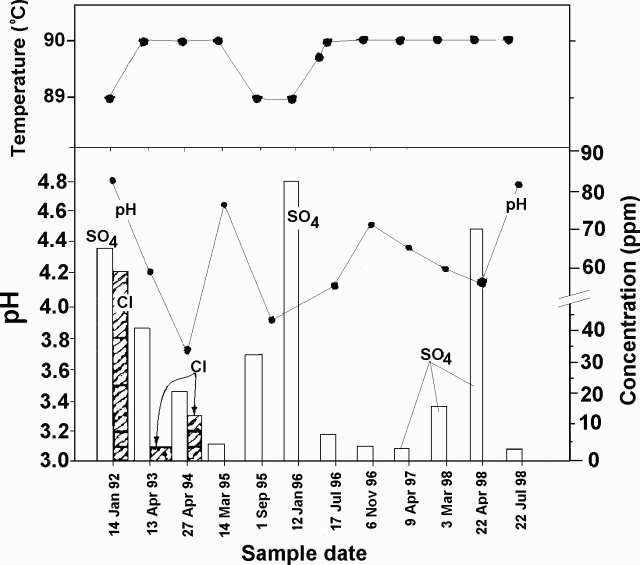 |
Figure 4. Turrialba fumarolic temperature (top) and condensate chemistry (bottom) shown for the interval 14 January 1992 to 22 July 1998. The measured pH appears as a series of points; Cl and SO4 concentrations, as shaded and unshaded bars, respectively. Note that the horizontal scale ("Sample date") is non-linear and that the lower right-hand vertical axis (Cl and SO4 concentration) is broken into segments of dissimilar scale. Courtesy of OVSICORI-LAQAT (National University). |
Table 3. Seismicity registered at Turrialba's seismic station VTU, January-July 1998. Courtesy of OVSICORI-UNA.
| Month | High-frequency | Low-frequency | Microseisms |
| Jan 1998 | 0 | 0 | 53 |
| Feb 1998 | 1 | 1 | 83 |
| Mar 1998 | 3 | 2 | 96 |
| Apr 1998 | 12 | 1 | 28 |
| May 1998 | 15 | 4 | 99 |
| Jun 1998 | 2 | 3 | 60 |
| Jul 1998 | 36 | 4 | 61 |
During 1998 the seismic system (station VTU, 0.5 km NE of the active crater) registered fewer than either 100 microseisms a month or five low-frequency earthquakes a month (table 3). The growth in the number of high-frequency earthquakes was thought to be related to the above-mentioned appearance of the new fumaroles in the central crater. Microseisms were generally weak, with amplitudes below 10 mm.
Information Contacts: E. Fernández, V. Barboza, M. Martinez, E. Duarte, R. Van der Laat, E. Hernández, and T. Marino, Observatorio Vulcanologico y Sismologico de Costa Rica, Universidad Nacional (OVSICORI-UNA), Apartado 86-3000, Heredia, Costa Rica.
A 4-fold increase in microseisms during December-April 1999
During the 17 months ending in May 1999, microseisms varied from ~30 to ~180 a month (figure 5). A 4-fold progressive increase began after December 1998.
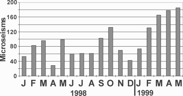 |
Figure 5. A histogram showing Turrialba's monthly microseisms during January 1998- April 1998. Courtesy of OVSICORI-UNA. |
In March 1999, the main crater's fumaroles were visible on the NE, N, NW, E and SW walls. Escaping gases appeared constant and had a temperature of 89°C. During March, the seismographic station VTU, located 0.5 km NE of the active crater registered a total of 252 earthquakes. Of those 81 had high frequency, with S-P duration of less than 1.5 seconds and frequencies greater than 3.0 Hz. The 166 microseisms registered had amplitudes under 10 mm, short durations, and frequencies between 2.1 and 3.0 Hz. An earthquake registered at 1846 on 7 March, with a Richter magnitude of 2.3, a depth of 7 km, and an epicenter 4 km NE of the main crater.
During April, the station VTU registered 287 earthquakes. Of those, 105 were of high frequency (with S-P of less than 1.5 seconds and frequencies above 3.0 Hz), and 4 were of low frequency. The 178 microseisms registered were of short duration; their dominant frequencies were between 2.1 and 3.0 Hz.
During May, a total of 309 events were recorded, of which 120 were type AB with S-P less than 1.5 seconds and frequencies less than 3.0 Hz. There were 3 low-frequency events. The 186 microseisms registered had amplitudes under 10 mm.
Information Contacts: E. Fernandez, V. Barboza, E. Duarte, R. Saenz, E. Malavassi, M. Martinez, and R. Van der Laat, T. Marino, and E. Hernandez, Observatorio Vulcanologico y Sismologico de Costa Rica, Universidad Nacional (OVSICORI-UNA), Apartado 86-3000, Heredia, Costa Rica; Wendy Perez Fernandez, Seccion de Seismologia, Vulcanologia y Exploracion Geofisica, Escuela Centroamericana de Geologia, Universidad de Costa Rica, POB 35-2060, San Jose, Costa Rica.
Microseisms diminish in number during July-November 1999
Mass wasting and elevated seismicity continued at Turrialba during July-November 1999 (table 4). The seismicity has appeared anomalously high since it increased suddenly during May 1996, escalating to 540 such events in September 1996. Microseisms have dropped since then, although they still remained at over 100 per month during September and October 1999. Between April and August 1999 scientists made surveys of the distance to a reflector 500 m from the active crater on the SW flank; these failed to show significant changes in length. After 18 September three new seismic receivers helped detect and locate three earthquakes, M 1.7-2.8, at depths of 3-11 km centered 2.5-10 km E, SE, and SW of the volcano.
Table 4. Monthly seismicity at Turrialba as recorded at station VTU, ~ 0.5 km E of the active crater. Microseisms were defined as earthquakes registered on the local seismic system with amplitudes under 15 mm. NR indicates information not reported. Courtesy of OVSICORI-UNA.
| Month | Total earthquakes | Microseisms | Type-AB earthquakes | Tremor duration | Max fumarolic temp. |
| Jul 1999 | 89 | 54 | 35 | NR | NR |
| Aug 1999 | 155 | 99 | 55 | NR | 90°C |
| Sep 1999 | 213 | 134 | 76 | NR | 91°C |
| Oct 1999 | 209 | 120 | 39 | 9 minutes | 90°C |
| Nov 1999 | 144 | 39 | 42 | 35 minutes | 90°C |
Information Contacts: E. Fernandez, E. Duarte, V. Barboza, R. Sáenz, E. Malavassi, R. Van der Laat, T. Marino, J. Barquero, and E. Hernández, Observatorio Vulcanologico y Sismologico de Costa Rica, Universidad Nacional (OVSICORI-UNA), Apartado 86-3000, Heredia, Costa Rica.
Seismic and fumarolic activity during January 2000-August 2001
During January 2000 to at least August 2001, seismic and fumarolic activity continued at Turrialba (table 5). On 12 March 2000 an M 3.2 earthquake was registered at a depth of 7 km, 6.5 km E of the active crater. The EDM lines (radial lines of distances) as well as the dry clinometers did not show significant changes during 2000.
Table 5. Summary of earthquakes and fumarolic temperatures at Turrialba during January 2000 to August 2001, registered by a seismograph at station VTU, located ~0.5 km SE of the active crater. Microearthquakes were defined as earthquakes registered on the local seismic system with amplitudes under 15 mm. Missing months indicate that no data was available for that month. NR indicates information not reported. Courtesy of OVSICORI-UNA.
| Month | AB earthquakes | LF earthquakes | Micro-earthquakes | Total earthquakes | Maximum fumarolic temperature (°C) | Comment |
| Jan 2000 | 29 | 2 | 33 | 64 | NR | Seismicity registered only 13 days. |
| Feb 2000 | 91 | -- | 75 | 166 | NR | Seismicity registered only 16 days. |
| Mar 2000 | 44 | -- | 65 | 113 | 91 | -- |
| Apr 2000 | NR | NR | NR | NR | 90 | -- |
| May 2000 | 286 | 5 | 330 | 616 | NR | -- |
| Jul 2000 | 50 | -- | 104 | 167 | 90 | -- |
| Aug 2000 | 76 | -- | 148 | 229 | 89 | -- |
| Sep 2000 | 243 | -- | 244 | 493 | 89 | -- |
| Oct 2000 | NR | NR | NR | NR | 93 | -- |
| Mar 2001 | 399 | 948 | 718 | 2075 | NR | -- |
| May 2001 | 128 | -- | 334 | 464 | 92 | An average of 15 earthquakes per day. |
| Jun 2001 | 3 | -- | 185 | 194 | 92 | Six VT earthquakes. |
| Jul 2001 | 24 | -- | 310 | 334 | 91 | -- |
| Aug 2001 | 14 | -- | 261 | 275 | 90 | -- |
Fumarolic activity was persistent in the N, NW, NE, and E walls of the main crater. Fumarolic activity in the S and SW walls diminished by July 2000 and began to reappear during October 2000. Activity in the N wall during May 2001 was more vigorous than previously. Small landslides persisted in the walls of the main crater, covering some fumaroles at the bottom and revealing other new ones.
During March 2001 sulfur precipitation and gaseous emanations in the internal walls occurred throughout most of the central craters. Gaseous activity also persisted in the W crater walls. During June 2001, a small patch of vegetation at the center of the main crater showed partial burns due to the gas escaping in the NE part of the main crater.
Information Contacts: Observatorio Vulcanologico y Sismologico de Costa Rica, Universidad Nacional (OVSICORI-UNA), Apartado 86-3000, Heredia, Costa Rica.
Increased degassing and opening of fissures
Non-eruptive fumarolic activity was reported at Turrialba through August 2001 (BGVN 26:11). This report covers the time interval January 2002 to mid-2007. Central and W craters were both scenes of fumarolic activity, and reports mentioned generally modest seismicity.
No eruption occurred, although fumarolic and seismic activity remained elevated and some other noteworthy changes also took place. Figure 6 presents a summary of seismicity measured during 1990-2006. Seismicity increased beginning in 1996, reached a peak in 2001 and although it remained elevated, it decreased somewhat from the peak through 2006. In general seismic activity was modest and of short duration with numerous micro-earthquakes of amplitude smaller than 15 mm, and frequencies between 2.1 and 3.0 Hertz (Hz).
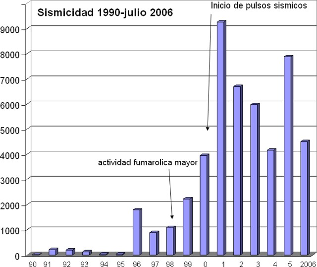 |
Figure 6. The numbers of earthquakes recorded at Turrialba during 1990 through 2006. Courtesy of Vilma Barboza (OVSICORI-UNA ). |
Fumarolic activity of 2002-2006. A summary of fumarolic activity at the central crater during the period 2002 through 2006 indicated the S, SW, NW, and N walls were collecting sulfur as a product of gas emissions. Monthly vapor temperatures at the central crater ranged from 87 to 91°C. In March 2006, a pair of cracks continued to be visible in the central crater's S, SE, and SW walls. By August 2006, a pair of cracks in the central crater were particularly significant. Visiting scientists noted that during August 2006, localized vegetation in and around the summit area had been heavily impacted by gases. Areas not affected by increased fumarolic activity in June 2005 had been burned, including a tree belt on the NW outer flank. Below the tree belt, farmers reported an intensification of gas odors. The shapes of the burned areas reflected prevailing wind directions.
From 2002 through 2006, Turrialba's W crater displayed fumarolic activity in the N, NE, W, NW, and SW sides with low levels of emission and gas temperatures remaining consistent from 88 to 93°C . New points of sulfur deposition were noted throughout the period.
An interval of increased seismicity (a pulse) recorded by station VTU located 0.5 km NE of the active crater occurred during 9 July to 14 September 2003. Through December 2003, the emissions continued to increase in the main crater, gradually generating gas columns that were carried W. Observers noted that the vegetation of the SW wall and W of the central crater continued to deteriorate, as well as effects such as heating of the ground, salt deposition at the surface, and escaping gases.
In June 2005, a significant increase in fumarolic gas emission was noted by OVISCORI-UNA and they also indicated changes in gases venting at the W crater. Chemical analysis indicated carbon dioxide gas had decreased and sulfur dioxide had increased, with the result that bushy species and minor plants that managed to survive in the open summit area (inner walls) became completely burned (figure 7). In the external walls to the N, NW, and W, the gases killed the vegetation.
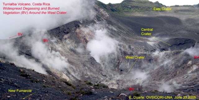 |
Figure 7. Increased degassing and resultant burned vegetation around Turrialba's W crater, as illustrated in this photograph from June 2005. Courtesy Eliécer Duarte, OVISCORI-UNA. |
A 2006 report noted that bushy species and minor plants that had previously managed to survive in the open summit area (inner walls) had by August 2006 appeared completely burned (figure 8). The tree belt on the NW outer flanks (reported in 2005 as partially burned) contained a significant percentage of dead birch (Alnus acuminata). The belt, ~ 200 x 900 m in area, included species taller than 25 m, and was visible from the lower inhabited farms where residents reported increasingly potent gas odors. The shape and location of the belt correlated with the seasonal prevailing wind directions.
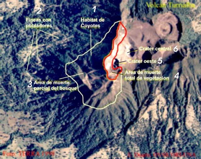 |
Figure 8. Aerial photograph depicting vegetation impacts at Turrialba and to its W, emphasizing zones affected by increased gas emissions from June 2005 through August 2006. Spanish labels translate as follows: 1) Coyote habitat, 2) Inhabited farms, 3) Area of partial deforestation, 4) Area of totally killed vegetation, 5) W crater, and 6) Central crater. Courtesy E. Duarte, OVISCORI-UNA. |
Behavior during January-August 2007. At the end of February 2007, a flight over Turrialba's summit revealed significant growth in the area of burned vegetation. On that day, dwarf and tall trees looked yellowish due to sustained degassing from the W crater.
On 21 April, observers measured the temperatures of fumaroles emitting steam at ~ 40°C as far as 1.5 km SW of the summit, a spot coinciding with the well known, ENE-trending Ariete fault. Two larger fumaroles were reported on 2 May located 200 m SW from the first one along the same fault. This site released significant vapor plumes (~ 90°C) that rose above the thick forest.
During June and July 2007, enhanced fumarolic activity was accompanied by new fractures at the summit. The fumaroles spread over a larger area and their temperatures increased to ~ 90°C. Micro-seismicity also grew.
The main fumarole at the bottom of W crater reached 138°C producing a distinctive sound similar to a high pressure valve; this sound could be heard up to ~ 500 m away. These fumaroles had melted sulfur, a phenomenon previously not seen in OVISCORI's more than 25 years continuous monitoring. Sulfur condensate colored most of the inner crater walls with a fine yellowish film.
Besides the multiple cracks associated with the expansion of the fumarolic areas around the W crater, two new ones appeared. Such cracks (longer than 100 m) oriented radially from the volcano's W and NW borders suggested a significant degree of summit instability. A wide fumarolic field between these two fractures along with the large number of vapor and gas spots on the outer walls also reflected considerable permeability in that area (figure 9).
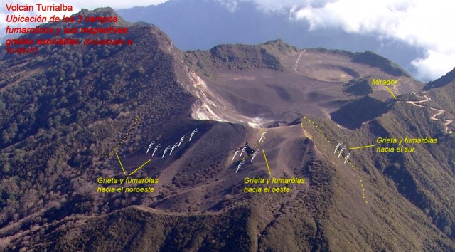 |
Figure 9. The three fumarolic fields and their associated cracks on Turrialba's NW outer wall, as seen 10 August 2007. Fumaroles are indicated by patten of white lines; cracks ("grietas") indicated by rows of dots. From left to right, the three fields are associated with cracks aligned approximately NW-SE, W-E, and S-N. The latter site contains two N-trending cracks adjacent new fumaroles. Courtesy OVISCORI-UNA. |
The effect of gases on the surrounding vegetation (in a 4-km radius) expanded to areas previously protected from damage by prevailing winds (figures 10-11). Acute chemical burning of important patches of natural forest had occurred. Vegetation to the NW, W, and SW appeared yellowish to dark brown (figure 10). By mid-2007 some of the effects had reached potato fields and dairy pastures.
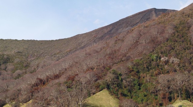 |
Figure 10. Acute effects of gases on vegetation are easily visible on Turrialba's steep NW outer wall (25 July 2007). Burns on leaf tissue diminish with distance from the source. Zones of dead climbing vines are visible at closest range in the photo's lower right corner. Courtesy OVISCORI-UNA. |
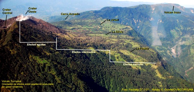 |
Figure 11. Despite the rainy season at Turrialba, the impact of volcanic gases on both exotic and native vegetation increased during June and July 2007. This 27 July 2007 photo identifies three zones of chemical burning, efectos agudo (acute effects), efectos intermedios (intermediate effects), and efectos menores (minor effects). Courtesy E. Duarte, OVISCORI-UNA. |
On 5 September 2007, OVSICORI-UNA visited Turrialba's outer NW wall to document the gas damage to vegetation in the area from the crater to the seismic station PICA, a distance of 2.5 km. The observers found three bands of severe damage: across an upslope area, a forested zone, and dairy-farm fields.
The upslope band contained a smaller, dense zone of sparse, dwarfed, woody bushes abutting the forest in a fine loose soil in steep terrain. Plants here were very dry and showed a surface layer of white-yellowish material. This effect was most intense within 100 m of the crater, but still partly visible up to 400 m away in patches. A second section with very dense growth was dead.
The mid-slope band through primary forest contained several tree species, including Jaúl and oak. Although all the trees in portions of this band had apparently died, they did so episodically with varying species seemingly more or less resistant to volcanic gases. The upper parts of the trees showed the greatest visible changes. Among the other plant species killed was a climbing vine that where killed turned an intense coffee color.
The topographically lowest band, consisting of pastures with occasional trees, had burned completely over a zone 400 m from the lower line of the forest, leaving grasses a straw-yellow color, and sufficiently brittle to be easily broken by contact. Gasses had also strongly corroded relatively new barbed wire in the ESE sector, and in lower parts of this zone they reacted with fixtures on buildings and damaged gardens.
The August 2007 OVSICORI-UNA report described ongoing fumarolic activity at Turrialba. At the Central and W craters, the respective maximum temperatures were 91°C and 176°C (up from 138°C during late July). Deposition at the fumaroles included sulfur and sulfurous sublimates, in some cases draping walls and forming minor flows up to 2 m from the point of emission. Small landslides were apparent on many sides of the W crater's walls, and these too were places where sulfur or sulfurous sublimates were seen. One of two major fracture directions trended SW; it was visible as a crack 100 m in length and underwent a maximum opening of 1 to 3 cm between 28 July and 16 August.
Information Contacts: Eliécer Duarte, Erick Fernández, and Vilma Barboza, Observatorio Vulcanológico y Sismológico de Costa Rica, Universidad Nacional (OVSICORI-UNA), Apdo. 2346-3000, Heredia, Costa Rica (URL: http://www.ovsicori.una.ac.cr/); Francois Robichaud, Université de Sherbrooke, 2500 boul. de l'Université, Sherbrooke, Québec J1K 2R1, Canada.
Fumarolic increases during August 2007-January 2008
Enhanced fumarolic activity accompanied by new fractures at the summit was noted during June-September 2007 (BGVN 32:08). The earlier report noted that the fumaroles had spread over a larger area and contained molten sulfur, a condensate previously not seen here in more than 25 years of continuous monitoring by the Observatorio Vulcanológico y Sismológico de Costa Rica-Universidad Nacional (OVSICORI-UNA). By mid-August 2007, acute chemical burning of important patches of natural forest had occurred. This report covers the period from October 2007 through January 2008.
During October, new sites of gas discharge, small landslides, and accelerated vegetation die-off were noted from various locations within and around the crater. Fumaroles were active and widespread across the central crater. Many exhibited sulfur deposits and those in the S, SE, and SW reached a temperature of 91°C.
Areas burned by acute acidification extended during November. Fieldwork conducted by OVSICORI-UNA confirmed an unusual output of gas from several fumaroles along the S outer wall of the volcano. Pastures turned yellowish near the upper areas, and native and exotic tree species were impacted as well as birch tree patches along most drainage basins.
During December, within the W crater, fumarole temperatures reached 280°C and significant sulfur deposits were noted. Local residents confirmed an unusual output of gas from several fumaroles along the S outer wall of the volcano. Areas burned by acute acidification extended during the month. On 5 December, members of the media and local communities observed a gas-and-steam plume from Turrialba that rose to an altitude greater than 5.3 km (figure 12).
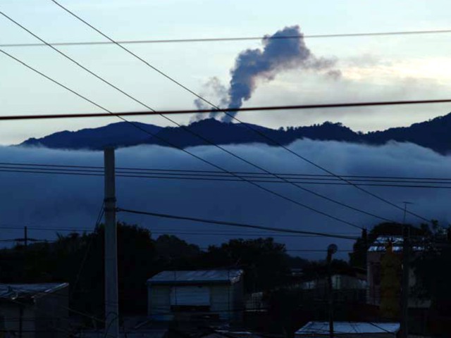 |
Figure 12. Column from Turrialba observed and photographed from Heredia City, located 40 km W of the volcano taken at 0540 on 5 December 2007. Courtesy OVSICORI-UNA. |
On a team visit between 30 and 31 January 2008, OVSICORI staff documented the progression of fumarolic activity in the W crater, the external W crater walls, and distant areas towards the W, NW, and SW. Some of the fumaroles correspond with two fractures. One to the SW of the W crater, trending SW, was 100 m in length and 2 to 3 cm wide, and deposited sulfur. The second crack to the NW of the W crater, also trending SW , had temperatures of 72°C and discharged steam and gas affecting the adjacent vegetation. To the NW of the W crater, the team studied an area of about 20 x 50 m with constant gas emission and a temperature of 88°C.
Information Contacts: Eliécer Duarte, Erick Fernández, and Vilma Barboza, Observatorio Vulcanológico y Sismológico de Costa Rica, Universidad Nacional (OVSICORI-UNA), Apdo. 2346-3000, Heredia, Costa Rica (URL: http://www.ovsicori.una.ac.cr/); Tellez and Francois Robichaud, Université de Sherbrooke, 2500 boul. de l'Université, Sherbrooke, Québec J1K 2R1, Canada.
Non-eruptive in August 2009, but degassing and with widening cracks
The Observatorio Vulcanológico y Sismológico de Costa Rica, Universidad Nacional (OVSICORI-UNA) continued monitoring the Turrialba non-eruptive interval of February 2008 through August 2009. As during the previous four months (BGVN 33:01), Turrialba continued to emit sulfurous gas from its central and W craters, and elsewhere, including some new cracks.
Activity during February-December 2008. During February 2008, the area around Turrialba affected by acid rain increased due to degassing. The degassing vents on the N, NW, W, and SW walls were rich in sublimated native sulfur. Gas-emission temperatures ranged from 72 to 132°C. Owing to prevailing winds, the vegetation most affected was on the N, NW, and SW flanks. The effects ranged from discoloration to death of various plant species. Residents in the area reported occasional nausea and irritation of the skin and eyes. On 22 February, local observers reported a gas plume up to ~ 2 km in height.
On the SE and SW walls of the central crater two cracks 2-3 cm wide and 100 m long continued to emit gases at ~ 90°C and produced sulfur deposits (figure 13). In stable atmospheric conditions gas columns often rose ~ 500 m above the crater. Rockslides sometimes covered emitting fumaroles, and new sulfur deposits tended to develop in these areas.
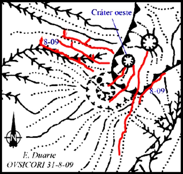 |
Figure 13. Elongated cracks (red lines on colored version) mapped at Turrialba during in August 2009. From first being noticed in mid-2009 to being measured in August 2009, some cracks opened by as much as 12 cm. Courtesy of OVSICORI-UNA. |
During 7-8 March 2008, gas sampling at the summit fumaroles determined the maximum temperature at the largest W wall vent was 278°C. Degassing vents were also noted at spots in the middle of the forest. In some cases emissions had killed all local vegetation.
On 7-8 March 2008, Erick Fernandez and Eliécer Duarte of OVSICORI, and the National University (UNA) took gas samples. The analysis, done by Jorge Andrés Diaz and Sergio Achí of the University of Costa Rica, revealed the presence of He at 80,000 ppm (parts per million), whereas the typical He concentration in the neighborhood of a volcano is 25 ppm.
OVSICORI-UNA reported continued degassing during August and September 2008. Multiple fumaroles and areas of sulfur deposition were noted in both the central and W craters. Fumarolic emissions on the S and SE flanks of the W crater continued to damage vegetation in that area.
On 23 September 2008, OVSICORI fieldwork confirmed a severe impact of acid-rain on areas that had been only mildly affected during the preceding 3 years of degassing. At least three sectors showed new impacts on vegetation and infrastructure, from the summit downhill ~ 3 km along the S and SE flanks. The upper sector, which includes the entire caldera and lower sectors to the E, S, and SE near the summit, had been severely burned during August and September. This area goes from the summit down to an elevation of ~ 2,900 m. By 23 September, weeds, dwarf vegetation, and trees had been completely burned; however in these areas some resistant species maintained some green and appeared seemingly viable. Along the external walls to the S of the W crater, plants had been burned down to the soil. Due to the removal of that natural coverage, erosion had cut extended radial gullies.
Between the elevations of 2,900 and 2,600 m, significant forest patches have been partially seared by extreme acidification, particularly the dense birch forests. Below 2,600 m elevation mild burns to the tree canopy and pasture areas were evident. The evidence of chemical burns due to the heavy gases are amplified along canyons and depressions. These conditions caused residents to voluntarily leave their farms in 2007.
Monitored SO2 emissions during the early part of 2008 had been ~ 750 metric tons per day (t/d). At the end of April 2008, an increase to ~ 1,000 t/d was noted, which then increased to ~ 2,000 t/d well into July. During the end of July the emissions declined to ~ 1,100 t/d. The increase in SO2 flux corresponded to increases in vegetation damage.
Activity during January-June 2009. In May 2009 OVSICORI reported ongoing fumarolic degassing during the preceding months from the central crater, from the N, NW, W, SW and S walls, from new vents on the S and SW walls, and other locations. Some locations continued to form sublimated sulfur deposits. The two cracks in the SE and SW walls had temperatures of ~ 87°C. The emissions in the W wall registered ~ 91°C and displayed sulfur deposits. In meteorologically quiet conditions, gas plumes were noted up to 500-600 m above the crater floor. All of these areas had experienced small landslides that occasionally covered some vents.
SO2 flux was variable during early 2009 (figure 14). The flux data were collected with a roughly consistent sun angle, between 0900 and 1100 in the morning on the SW flank. In the graph the SO2 flux varies between ~ 0 and ~ 2,000 t/d, the maximum flux occurred on 23 April.
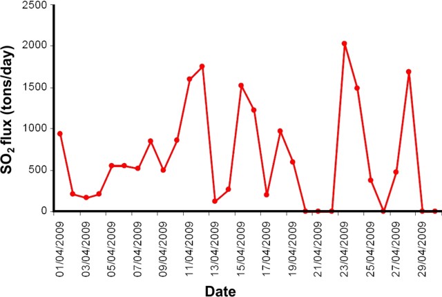 |
Figure 14. SO2 fluxes measured at Turrialba during April 2009 (with y-axis showing SO2 flux in metric tons per day and x-axis dates in the format, month/day/year). Courtesy of OVSICORI-UNA. |
On 14 June 2009, OVSICORI-UNA reported that fumarolic activity from Turrialba had been observed all around the upper flanks of the active W crater. During the previous two months, the fumarolic activity was also accompanied by widening radial cracks (1.5 cm on average), 1-2 km tall gas-and-vapor plumes, and one sustained seismic swarm. Temperatures of fumarolic vents in the lower parts of the crater were between 120 and 160°C. The temperature of summit cracks was 94°C. By mid-June, dairy pastures and forests had been chemically burned as far away as 3.5 km NW and W. During the last week of August 2009, the W and NW lower flanks, sectors previously reported with moderate effects, showed acute burns, and yellow pastures within 3 to 4 km radius (figures 15, 16, and 17).
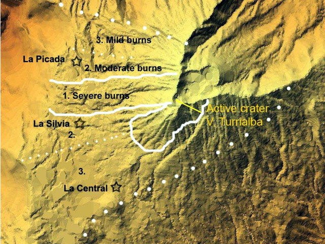 |
Figure 15. Vegetation damage as of late August 2009 at Turrialba plotted on a shaded relief map by F. Robichaud. E. Duarte and others found that damage was generally within several kilometers of the volcano and in broader areas on the W flanks. The large dotted line indicates the boundary of detectible damage. Severe damage covered an irregular area, a strip both directly W of the active crater and a lobe to its SW as well. Courtesy of OVSICORI-UNA. |
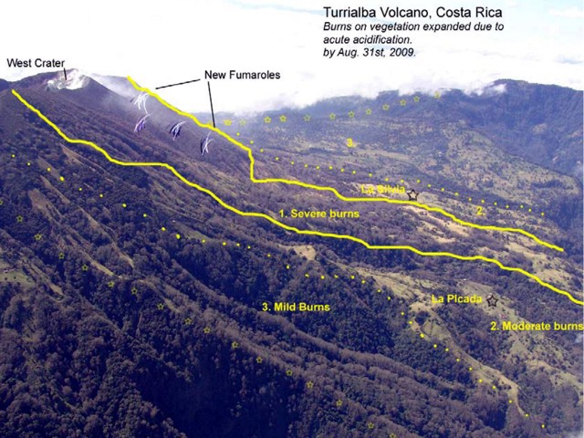 |
Figure 16. Newly emerging fumaroles on Turrialba's upper NW flank and burns on vegetation, August 2009. Courtesy of OVSICORI-UNA. |
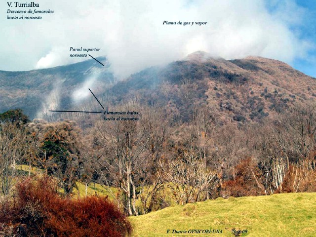 |
Figure 17. A view from Turrialba's seismic station PICA on the NW flank, showing active degassing from a variety of locations in August 2009. Left mid-ground shows plumes from the lowest fumaroles yet developed on this flank. Green grass is in the foreground, but most of the other foliage is brown to orange. Courtesy of OVSICORI-UNA. |
Near the Toro Amarillo river (4 km E of the crater) chemical burning surrounds stands of trees. Such whitening effect had been previously reported at the end of 2007 for areas closer to the active crater, 1.5 km W (figure 18).
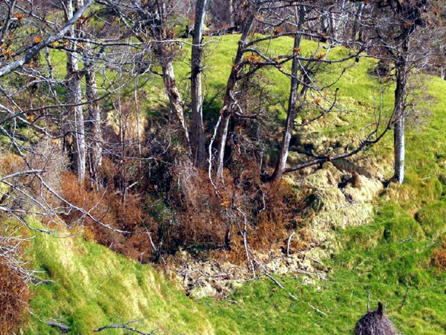 |
Figure 18. An example of a zone with intense burns on grass at the foot of injured trees, damage attributed to acidic gases from Turrialba. The spot is near the Toro Amarillo river in late August 2009. Courtesy of OVSICORI-UNA. |
Several elongated cracks were mapped just south of the W crater as well as 1 km downslope NW. One main crack, noticed during mid-2009 due to sulfur depositions on the surface, was opened by August in places as much as 12 cm. In late August 2009 it emitted gasses at 90°C. The crack trends E-W, in places intersecting a trail used to reach the summit's SW and W sides.
The last two years have caused residents to leave owing to the burned and dead pastures. Some commented on their apprehension related to the emergence of the lower fumaroles. Along the S side of the Irazú summit located 10 km SW of Turrialba's summit, mild burns have been observed on patches of birch, eucalyptus and pine. Lesser impact was reported last year in that same area.
False eruption report. The Washington VAAC received surface observations from an airport near the volcano erroneously indicating an eruption on the morning of 23 September 2009.
The VAAC decided to initially describe the activity as an eruption because it was the first time the airport had reported emissions, the volcano was known to have been degassing for some time, and early morning satellite imagery showed cloud cover, preventing good analysis. In addition, attempts to reach local volcanologists by telephone using contact numbers from the ICAO [International Civil Aviation Organization] handbook and the OVSICORI webpage were not successful. OVSICORI-UNA personnel reported a few hours later that the volcano had not erupted. As a result of the incident, the VAAC has obtained current contact numbers, including personal cell phones, for future use.
Information Contacts: Eliécer Duarte, Erick Fernández, Vilma Barboza, S. Miranda, L. Ortiz, G. Chavez, Jorge Brenes, Thomás Marino, Javier Pacheco, Juan Segura, and Rodolfo van der Laat, Observatorio Vulcanológico y Sismológico de Costa Rica, Universidad Nacional (OVSICORI-UNA), Apdo. 2346-3000, Heredia, Costa Rica (URL: http://www.ovsicori.una.ac.cr/); Francois Robichaud, Université de Sherbrooke, 2500 boul. de l'Université, Sherbrooke, Québec J1K 2R1, Canada; Washington Volcanic Ash Advisory Center, Satellite Analysis Branch (SAB), NOAA/NESDIS E/SP23, NOAA Science Center Room 401, 5200 Auth Rd, Camp Springs, MD 20746, USA (URL: http://www.ospo.noaa.gov/Products/atmosphere/vaac/).
Phreatic eruption of 5-6 January 2010 opens SW crater's upper wall
Since 2002, elongate cracks have opened at Turrialba, and new points began degassing, emitting high levels of sulfurous gas and helium, but no eruptions had occurred (BGVN 32:08, 33:01, and 34:09). Ongoing fumarolic activity through August 2009 caused significant damage to local vegetation (BGVN 34:09). This report continues through February 2010. Phreatic eruptions on 5 and 6 January 2010 resulted in ashfall ten's of kilometers from the active W crater. New vents formed on the crater wall, ultimately merging into an elongate fissure.
On 25 September 2009, scientists from the Observatorio Vulcanológico y Sismológico de Costa Rica, Universidad Nacional (OVSICORI-UNA) reported results from three trips to inspect new fissures and to assess the impact of gases. Gases blown 10 km SW mildly burned trees to a greater degree than the previous year. Vegetation within a 4-km radius on the W, NW, and E flanks was also burned more severely that previously noted. Several elongated fissures were documented on the rim S of the W crater, as well as 1 km downslope to the NW. One E-W-trending crack that was first seen several months before had opened as much as 12 cm, and emitted gas and vapor at 90°C. On the lower NW flanks, at least three radial fissures emitted high gas-and-steam plumes. Some fissures near the summit were 5-10 cm wide. The last of the remaining residents in the affected areas had moved away due to the intensification and impact of the gases.
Report from the Red Sismológica Nacional, January 2010. Gerardo J. Soto sent a report by the Red Sismológica Nacional (National Seismological Network; RSN: UCR-ICE) summarizing events during early January. The seismic signals recorded during 2009 consisted mostly of B-type earthquakes, tremor, and some A-type earthquakes. The seismic records through the afternoon of 3 January remained typical, but after 1000 on 4 January signals underwent a sudden change. Tremor became common and was of long duration (~ 4 events/hour with typical durations of 10-20 minutes), but signals did not suggesting internal fracturing. Abundant low-frequency signals (B-type earthquakes) corresponded with substantial gas plumes. After 1400 on 5 January tremor occurred almost constantly. Two strong earthquakes occurred, at 1429 and 1445.
These two earthquakes coincided with the first reports of ash, which fell mainly over the farms adjacent to La Central and La Silvia, Capellades town. Finer ash was reported at Tierra Blanca, Llano Grande and Tres Ríos, ~ 25 km SW, and in eastern San José, ~ 30 km away. The ash was expelled for over 22 hours, in a continuing sequence of pulses.
The RSN report further stated that field and aerial trips inspected the two small pits that opened on the upper SE wall of the SW crater. These pits later joined and formed a fracture-like structure (aligned N40°E, the same trend as the tectonic depression and faults on the summit). The ash emitted from the pits was devoid of new (juvenile) magma material and most clasts were hydrothermally altered. Fumaroles expelled gas and ash at high pressure with a jet-type noise heard several kilometers away. Observers approaching the pits on the 6th watched pulsating emissions coming from both new vents on the upper wall.
Report from OVSICORI-UNA, January-February 2010. An OVSICORI-UNA report written on 6 January also noted that the phreatic eruption began at 1400 on 5 January, followed by reports of ashfall as far away as 30 km, particularly in areas to the SW. Residents of the village La Central located ~ 4 km SW of the crater heard nothing but received fine ash (figure 19) accompanied by rain. In contrast, in the village of La Silvia located roughly the same distance W of the crater, people heard noises attributed to eruptions. Erupted material was generally fine-grained (sub-millimeter in diameter) and dark.
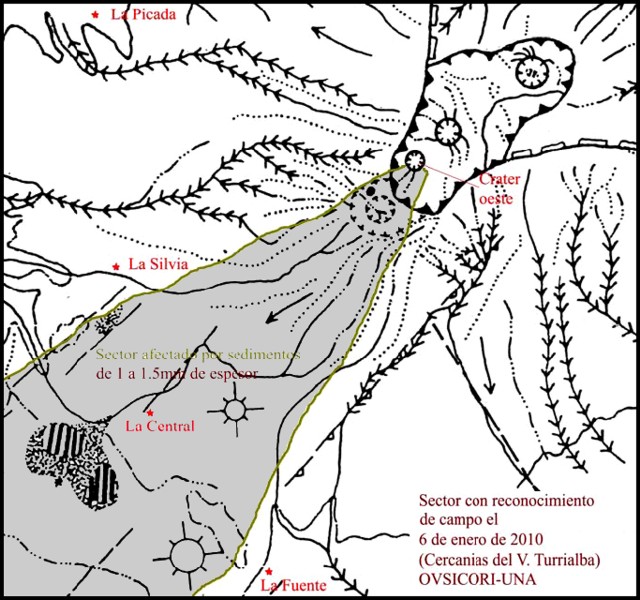 |
Figure 19. Sketch map of Turrialba emphasizing the fresh deposits mapped on 6 January 2010 (shaded area). The town of La Central (~ 4 km from the W crater) lies on the approximate dispersal axis and received 1-1.5 mm of ash fall. Courtesy of OVSICORI-UNA. |
Mapping by OVSICORI-UNA on 6 January traced the deposit WSW (figure 21); the deposit had a thickness of 1-1.5 mm between La Central and La Silvia. At 8 km from the vent on the road near Oreamuno the deposit was ~ 0.5 mm thick. Some fine ashfall was seen 15 km from the vent (at Llanos Grande) and reached ~ 30 km away to neighborhoods of SE San Jose. The delicacy of the deposit and the associated rain meant that some of the best samples came from roof tops and plant leaves. On corrugated roofs the uppermost portions of the ridges still preserved considerable ash. Some of the near-source ejecta were on the order of a meter in diameter.
Field observations on 6 January revealed that two small vents had opened and joined together on the SE inner wall of the SW crater. Gas emission temperatures were more than 350°C. On 8 January seismic activity and gas emissions decreased. Observations on 9 January revealed that the combined vent was about 20-25 m wide and 65-80 m long (figures 20 and 21).
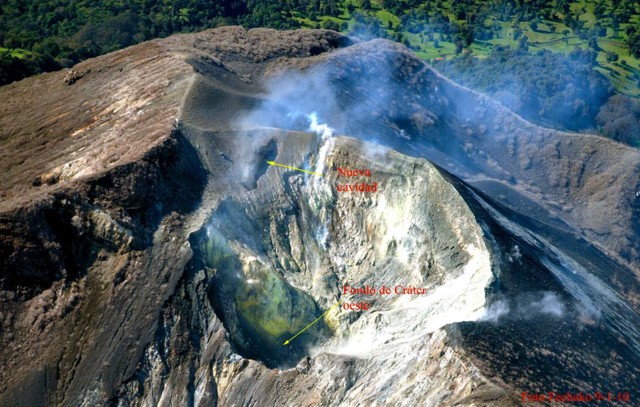 |
Figure 20. An aerial view on 9 January 2010 of Turrialba's W crater and one or more new cavities developed in the upslope area (see enlarged view in next figure). Courtesy OVSICORI-UNA. |
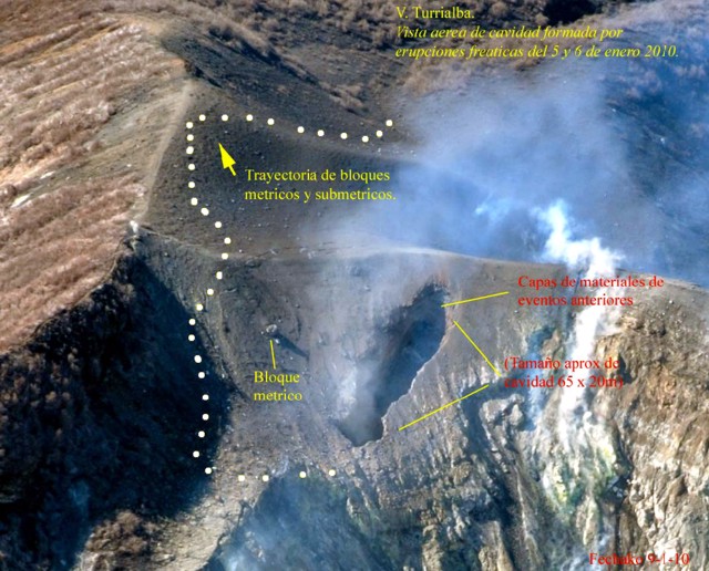 |
Figure 21. Close-up of the area affected by Turrialba's phreatic eruption as seen from the air on 9 January 2010. The vent on the far wall began as two small separate ones. The cover of fresh fine-grained deposits appears as a smooth area around the new vent. Some of the larger near source ejecta reached on the order of a meter or so across. Courtesy OVSICORI-UNA. |
A plume on 15 February that reached 1.5-2 km in height was photographed by OVSICORI-UNA (figure 22). The noise from the emission was heard 4 km to the SW.
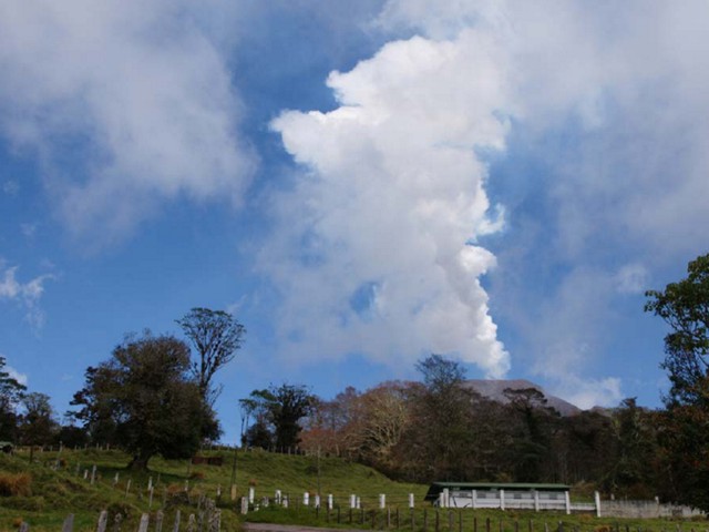 |
Figure 22. Photograph of a weak, inclined steam-and-gas plume from Turrialba taken on 15 February 2010. Courtesy OVSICORI-UNA. |
Aviation notices, January 2010. Washington Volcanic Ash Advisory Center (VAAC) reports started on 7 January, and began with pilot reports of ash to the E of the summit, but analysts lacked clear evidence of ash based on satellite imagery. METAR reports (routine, in most cases hourly, aviation weather reports from places such as airports) continued to mention the plume on the 7th, but weather clouds prevented detection of possible ash clouds. Later on the 7th, analysts began to rely on a wider array of data, and although still unable to see the plume in imagery, they began to put out numerous regular reports through the 9th. On 16 January the VAAC reported that the "Observatory has confirmed that there are no ash emissions at this time. Gas and steam emissions are possible."
Information Contacts: E. Duarte, E. Fernández, J. Brenes, R. Van der Laat, and T. Marino, Observatorio Vulcanologico Sismologica de Costa Rica-Universidad Nacional (OVSICORI-UNA), Apartado 86-3000, Heredia, Costa Rica (URL: http://www.ovsicori.una.ac.cr/); Gerardo J. Soto, Red Sismológica Nacional, Escuela Centroamericana de Geología (UCR). Apdo. Postal 214-2060, San José, Costa Rica (URL: http://rsn.ucr.ac.cr/); Washington Volcanic Ash Advisory Center, Satellite Analysis Branch (SAB), NOAA/NESDIS E/SP23, NOAA Science Center Room 401, 5200 Auth Rd, Camp Springs, MD 20746, USA (URL: http://www.ospo.noaa.gov/Products/atmosphere/vaac/).
Frequent degassing and occasional ashfall, March 2010-June 2011
During 5-6 January 2010, Turrialba discharged a phreatic eruption that resulted in a new vent and ashfall up to 30 km from the crater (BGVN 35:02). This report discusses activity from February 2010 through October 2011. Portions of this report were initially synthesized and edited by Shereena Dyer, as part of a graduate student writing assignment in a volcanology class at Oregon State University under the guidance of professor Shan de Silva.
Since the January eruption, Turrialba (figure 23) has continued to eject gas and ash intermittently, maintained elevated fumarolic output and temperatures, and produced strong SO2-bearing plumes from the vent. This activity continued over much of the reporting interval. The Observatorio Vulcanológico y Sismológico de Costa Rica-Universidad Nacional (OVSICORI-UNA) annual report highlighted the 5-6 January eruption as the key event during 2010. According to OVSICORI-UNA, field observations on 6 January found that two small vents had opened and joined together on the SE inner wall of the SW crater. Current monitoring includes a web camera 600 m from the active crater that takes an image every 10 seconds.
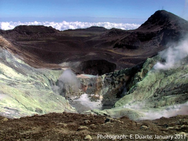 |
Figure 23. View of Turrialba's SW crater (depression in foreground) and central crater (at distance). The photo documents the character of persistent ongoing fumarolic degassing on an unstated day in January 2011. The yellow zones on the hillsides represent sulfur-bearing deposits sublimated from the sulfur-rich gas emissions. Courtesy of OVSICORI-UNA. |
After the 5-6 January eruptions, emission levels dropped. In late February 2010, scientists found a pool of molten sulfur at the base of the S crater wall with a temperature of 153°C.
OVSICORI-UNA reported that scientists visited Turrialba on 7 March 2010. A gas plume, common with this volcano, was observed that night rising 1.5 km above the crater and drifting NW. Noises from the crater were described as sounding like a jet engine and rumblings. The January 2010 vent emitted gas in March with surface temperatures between 300 and 320°C. Small blocks 3-12 cm in diameter and of different colors dominated the surface around the vent. Lithics ejected 30-50 m away from the vent measured 170°C. Incandescence seen at night originated from the vent that ejected reddish-colored tephra. Two SO2 measurements taken on or around 13 March from a ground-based spectrometer yielded 1,100 and 750 t/d, the former taken closer to the volcano.
According to OVSICORI-UNA, most of the gas emitted in April originated from the January 2010 vent; in April it produced plumes that rose 2 km above the crater rim. Gas also rose from other areas, including fissures SW of the W crater and from multiple vents and fissures in the main crater. Gas plumes mainly drifted NW, W, and SW, coinciding with areas where vegetation had suffered the greatest damage from the gases.
In April 2010, OVSICORI-UNA reported that multiple years of rain data had been collected at the station La Silvia on the W flank and was frequently found to be acidic (pH often well below 5). During 2007 though mid-2010, the rain had pH 2.8-5.7 and elevated specific conductivity (figure 24). Note that the lowest pH values on the plot were collected during 2009 and 2010.
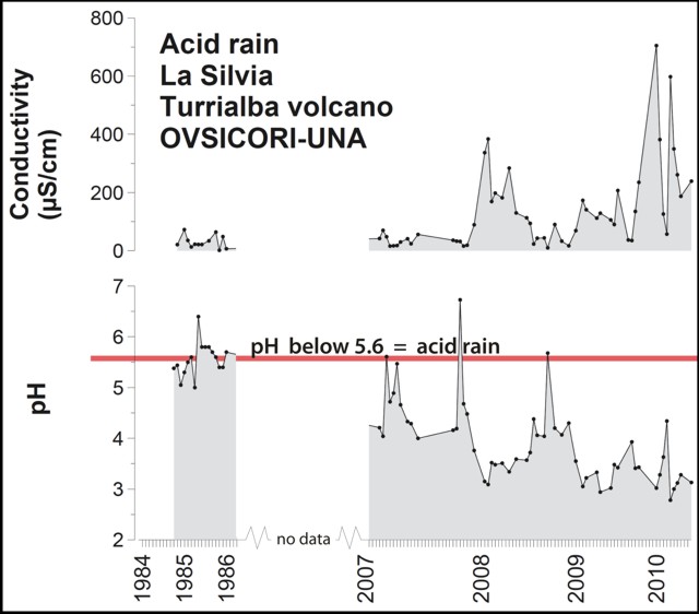 |
Figure 24. Specific conductivity (microS/cm) and pH of rainfall collected at La Silvia station associated with Turrialba during parts of the 1980s and then from 2007 through mid-2010. Note break in horizontal scale owing to absence of data. Courtesy of OVSICORI-UNA/CONARE. |
In May scientists noted that on the NW, W, SW sides there were new effects of acid-rain-damaged leaves and vegetation up to 4 km from the main crater. During August, observers noted farms 18 km SW of Turrialba with burns on onions, chemical damage attributed to volcanic gases.
A farm 3 km NW of the summit appears in comparative photos from 2007 and 2011 (figure 25). The houses in the photos were abandoned for a few months after the seismic swarms in the middle of 2007. The residents returned during February-March 2008, only to permanently leave in the middle of 2008 due to harsh atmospheric conditions. This farm remained abandoned in November 2011. Many others were also abandoned in areas of intense impact.
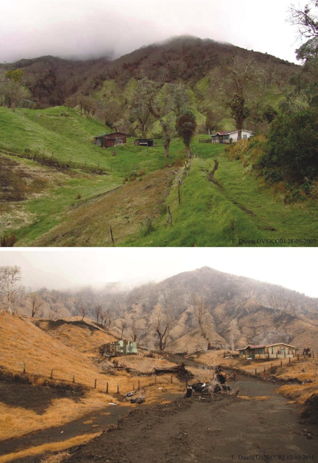 |
Figure 25. For Turrialba, comparative views from 2007 (top) and 2011 (bottom) of a farm below the crater and to the NW. These photographs show the effects of acidification on the vegetation and infrastructure. Courtesy of OVSICORI-UNA. |
Based on web camera views, the Washington Volcanic Ash Advisory Center (VAAC) reported that on 24 July 2010 a plume of steam, gas, and ash drifted W. Over the next three hours, the plume became more diffuse and steam-rich. Another ash emission was observed on 15 August 2010; the plume drifted about 600 m E of the active crater. Satellite imagery showed an approximately 10-km-wide ash plume drifting 15 km W.
The volcano was relatively quiet during November and December. In January 2011, vegetation damage from acid rain could be observed on the SW, W, and NW flanks. Residents in the village of Silvia, 2.3 km SW of the crater, reported a strong stench of SO2 during the month. On 14 January, nearby residents reported minor ashfall and rumbling noises, and again, strong sulfurous odors. OVSICORI closed the Turrialba Volcano National Park temporarily, evacuated a few people as a precaution, and installed a surveillance base in the town of La Central (~4 km SW of the crater). OVSICORI-UNA noted that a blue-and-white gas plume rose from Turrialba the next day.
During a visit to the volcano in January 2011, OVSICORI-UNA found that a 2- to 5-cm-thick layer of freshly ejected material, with clasts ranging in size from a few millimeters to 5 cm, blanketed the W edge of the crater. Officials discovered two small landslides on the walls of the crater. The walls were considered unsafe due to the loose material. The cavity in the crater that formed in January 2010 had been widened as a result of falling material and the W part of the cavity was offset by about 4 m. A new cavity in the vent appeared to have formed from one of the explosions. Heavy rainfall created a large gully, incising the W edge of the crater at a depth of 0.4-1.5 m. Despite the intense rainfall, the crater was covered in sulfur-bearing deposits. An "eerie sound," which at times could be heard kilometers from the summit, was associated with the emission of gas. A gray plume had a temperature at the vent ranging from 480-498°C.
OVSICORI-UNA reported that on 9 June 2011 scientists conducting fieldwork at Turrialba observed a new lake in the SW crater. Since February, rock landslides along with abundant mud and clay had accumulated in the bottom of the crater, blocking the vent. Meteoric water from rains starting in May had formed a light-green-colored lake that was 70 m in diameter and ~1 m deep. Minor bubbling in the SW and NE shores was noted, and steam and sulfur dioxide gas emissions rose from many fumarolic vents around the crater.
OVSICORI-UNA reported on 12 October 2011 that degassing at Turrialba had affected the vegetation, soil, infrastructure, and economy (figure 25). Acidification of the soil had impaired, possibly permanently, vegetation growth; the economic effect on farms and livestock has yet to be determined. A school building near the volcano was still used by students and teachers, despite having been deemed unsafe. The extent of the effect of acidification on livestock and the economy had not yet been determined.
Reference. OVSICORI-UNA, 2010, Real-time webcamera of Turrialba volcano, Costa Rica (URL: http://www.ovsicori.una.ac.cr/vulcanologia/videoturri.html)
Information Contacts: Observatorio Vulcanológico y Sismológico de Costa Rica-Universidad Nacional (OVSICORI-UNA), Apartado 86-3000, Heredia, Costa Rica (URL: http://www.ovsicori.una.ac.cr/); Washington Volcanic Ash Advisory Center (VAAC), Satellite Analysis Branch (SAB), NOAA/NESDIS E/SP23, NOAA Science Center Room 401, 5200 Auth Rd, Camp Springs, MD 20746, USA (URL: http://www.ospo.noaa.gov/Products/atmosphere/vaac/).
New fumarolic vent opens on the SW flank of the W crater on 12 January 2012
Turrialba is the eastern-most of Costa Rica's active volcanoes, located 65 km E of the capitol, San Jose. The previous Bulletin report discussed frequent degassing and occasional ashfall between March 2010-June 2011 (BGVN 36:09). This report discusses activity between July 2011 and May 2012.
A recent comprehensive report prepared by Observatorio Vulcanológico y Sismológico de Costa Rica-Universidad Nacional (OVSICORI-UNA) provides an excellent background: "Since May 1996, Turrialba volcano has shown an important increase in activity, which can possibly be interpreted as precursory of a new eruptive phase. The volcano-tectonic activity and degassing increase is particularly noticeable since 2007, and even more since the opening of the first fumarolic vent in the W crater [the main crater 'pLa Quemada'] in January 2010, which suggested a magmatic intrusion between 2005 and 2007 as well as the beginning of a new eruptive phase. A new vent opened on January 12th, 2012 (Boca 2012 or 2012 vent) on the southeast external flank of the W crater, with few hours of ash emission, followed by a second ash emission from the same vent on January 18th, 2012." A chronology of events leading up to the 12 January 2012 event is shown in table 6.
Table 6. Events since 1996 leading up to the 12 January 2012 vent opening event, and associated previous Bulletin coverage. Dates and event descriptions courtesy of OVSICORI-UNA.
| Date | BGVN report(s) | Remarks |
| 1996 | 21:06 (Jun 1996), 21:08 (Aug 1996), 21:12 (Dec 1996) | During the first four months of 1996 nearly no events were registered. After 23 May Turrialba registered a sudden increase in microseismicity. In late May there were over 50 events; in June, 246 events. During July, observers witnessed weak fumarolic activity continuing along the NE, N, W, and S sides of the crater which included 146 local earthquakes. In August, 299 local earthquakes were detected. |
| 2001 | 26:11 (Nov 2001) | Seismic swarms and increase in the fumarolic activity with the appearance of magmatic gases. |
| 2003-2005 | 32:08 (Aug 2007) | Seismic swarms and increase in the fumarolic activity with the appearance of magmatic gases. |
| 2007 | 32:08 (Aug 2007) | Seismic swarms and increased fumarolic activity at the bottom of the W crater, forming a plume up to 2 km height. |
| 2007-2012 | 33:01 (Jan 2008), 34:09 (Sep 2009) | Increase in the fumarolic activity with a strong magmatic component and high temperatures. |
| 5-6 Jan 2010 | 35:02 (Feb 2010) | Phreatic eruption and opening of the 2010 vent on the W flank inside the W crater accomanied by ash emission. |
| 14 Jan 2010 | -- | Small ash emission. |
| Early 2011 | 36:09 (Sep 2011) | "Roaring" sound from the vent located on the N side of the W Crater. This vent may have opened at the beginning of the rainy season, around May 2011; no confirmation possible. |
| 12 Jan 2012 | Current report | Opening of the 2012 vent on the SE flank of the W crater accompanied by an ash emission. |
Seismicity at Turrialba from early November through December 2011 was variable with event frequency ranging from as low as 20 events per day to an occasional high of 80 events per day. The frequency of events dropped significantly in early December to generally less than 60 per day until there was a dramatic increase on 31 December when 155 seismic events were recorded. Event frequency in early January 2012 showed a steady increase from 40 events per day reaching about 80-100 events per day between 6 and 13 January.
Eruption on 12 January 2012. After midnight on 9 January 2012, residents of the Central Valley heard booming and crashing sounds. Investigators at OVSICORI-UNA reviewed the seismic records but did not find associated seismic or volcanic activity. On 11 January, residents again reported several instances of rumbling. On 12 January, OVSICORI-UNA reported that a new vent, located on the SE flank of the volcano's W crater had opened. According to OVSICORI-UNA, the new vent exhibited "a vigorous output of bluish gas at high temperature (T > 592°C) that generated a jet-like sound audible from the visitor lookout." This activity included a few hours of ash emission. A second ash emission from the same vent occurred on 18 January (see subsection below). Seismic recordings, deformation, and diffused gas flux measurements allowed the conclusion that the opening of the 2012 fumarolic vent is not due to a change in the magmatic activity but to an excessive shallow accumulation of gas. This conclusion is substantiated by information obtained from a network of Electronic Distance Measurement (EDM) equipment using five reference points (prisms) which have been taking measurements since 2009. No significant variations of the distance relationships that would coincide with the ash emissions of 2010 and 2012 had been noted. EDM data after March 2011 showed a decrease in measured distances, mainly in the N direction with small variations in the other directions. This information is considered corroborated by Global Position System (GPS) data provided by two GPS stations which show a small but continuous trend of decreasing distance observed during April 2010-January 2012.
Similar vent openings occurred at Turrialba prior to the 1864-66 eruption and at Irazú volcano prior to its 1963-65 eruption. Hence, other openings of fumarolic vents can be expected in the future, especially along the fractures and weak zones aligned in a SW-NE direction that passes by the three upper craters of Turrialba.
The activity of 12 January was a pressure release on the SE flank of the W crater. OVSICORI-UNA considered the release to have penetrated weakened rock, not a magmatic or phreatic (steam-driven) eruption. (The rock at the summit of Turrialba is considered to be very weak due to the intense rainfall and the persistent hydrothermal activity at the summit. This weakness facilitates the development of vents.) An ash plume rose ~500 m above the crater and drifted NNE and NNW, rising to an altitude of ~4 km. Later that day residents reported a dark plume coming from the main crater and a white vapor plume that rose from the fumarolic vent which had formed in the main crater on 5 January 2010. The emissions caused OVSICORI-UNA to raise the Alert Level to Yellow in the communities of La Central (34 km SW), Santa Cruz (7 km SE), and around the perimeter of the crater. Towns of Jiménez (21 km N), Oreamuno (45 km SW), Alvarado (38 km SW), and Cartago (25 km SW) remained at Alert Level Green. Ashfall was reported in Tres Ríos (27 km SW).
Gas emission analysis the day before the opening of the 2012 vent (11 January) showed high values of CO2 and H2S over the entire E flank of the W crater. A 115-m-long liquid sulfur flow was observed in the main crater from the E side of W crater.
Eruption on 18 January 2012. During the evening of 18 January 2012, scientists observed gas emissions and ejection of tephra from the vent. They also observed reddish flames from combusting gas, estimated to be ~700°C. Degassing of Turrialba is considered a normal ongoing activity. An OVSICORI-UNA pilot observed an ash plume that rose to altitudes of ~4.3-6.1 km.
The seismogram from the 18 January eruption (figure 26) showed strong tremor coincident with the tephra and gas emissions. The tremor, which started at 1455, was most intense between 1502 and 1610 according to OVSICORI-UNA. Figure 26a shows >5,000 seconds of the most intense part of the tremor having significant variations in amplitude, especially at the beginning of the activity. Figure 26c shows the signal's frequency content over the same interval, with the highest normalized amplitudes having peaks between 5 and 15 Hz.
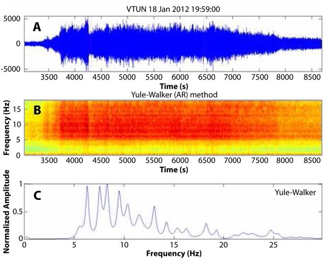 |
Figure 26. (a) A seismic recording for Turrialba on 18 January 2012 at station VTUN showing the most intense phase of the tremor that prevailed during the eruption that day. (b) Spectrogram of the seismicity shown in (a). (c) Normalized frequency spectrum of the seismic signal; the main peaks are between 5 and 15 Hz. Courtesy of OVSICORI-UNA. |
A false color satellite image of Turrialba taken on 21 January 2012 highlights ongoing impacts to vegetation from high gas emissions (figure 27). One of the concerns of the government is the amount of acid rain that has fallen on the region surrounding Turrialba. The acid rain, with a pH as low as 3.2, has degraded the local agricultural and livestock economy.
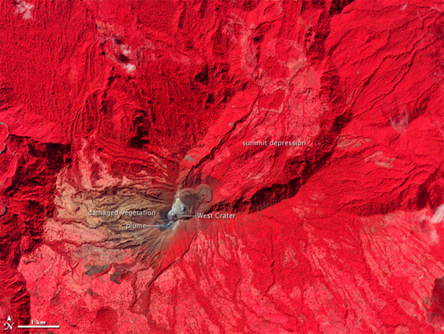 |
Figure 27. A false-color satellite image of Turrialba (a combination of near infrared, red, and green light) acquired on 21 January 2012. Healthy vegetation appears bright red, while vegetation damaged by years of acidic gas emissions is brown. Bare ground in the summit craters is brown or gray. This image was acquired by NASA's Advanced Spaceborne Thermal Reflecton and Emission Radiometer (ASTER) instrument aboard the TERRA satellite. Courtesy of NASA Earth Observatory. |
Vent incandescence in February 2012. A nocturnal visit to the W crater by volcanologists from OVSICORI-UNA on 2 February revealed several incandescent spots. Figure 28 (a view from the overlook taken on 9 February), shows a panoramic view of vent locations in relation to the West, Central, and East Craters. Each vent had different gas and vapor output, and different incandescence intensities. The 2012 vent, which opened on 12 January, registered temperatures above 700°C on 22 February. Continued degassing was noted in conjunction with incandescent spots at several locations on the W crater (figure 29).
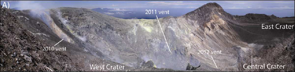 |
Figure 28. A panoramic view of the relative locations of the three vents which have been the sites of activity since 2010. Courtesy of OVSICORI-UNA. |
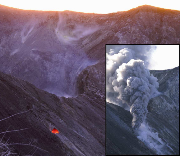 |
Figure 29. A view of the 2012 vent from the overlook taken on 9 February 2012. The insert on the right is the second ash emission from the 2012 vent on 18 January. Courtesy of G. A. Avard, OVSICORI-UNA. |
Information Contacts: Avard G., Pacheco J., Fernández E., Martínez M., Menjívar E., Brenes J., van der Laat R., Duarte E., Sáenz W., Observatorio Vulcanológico y Sismológico de Costa Rica-Universidad Nacional (OVSICORI-UNA), Apartado 86-3000, Heredia, Costa Rica (URL: http://www.ovsicori.una.ac.cr/); Washington Volcanic Ash Advisory Center (VAAC), Satellite Analysis Branch (SAB), NOAA/NESDIS E/SP23, NOAA Science Center Room 401, 5200 Auth Rd, Camp Springs, MD 20746, USA (URL: http://www.ospo.noaa.gov/Products/atmosphere/vaac/); Tico Times (URL: http://www.ticotimes.net/); Reuters (URL: http://www.reuters.com/); NASA Earth Observatory (URL: http://earthobservatory.nasa.gov/).
Decreased seismicity and emissions in 2012
As noted by our previous report (BGVN 37:06), on 12 January 2012 Turrialba emitted ash for a few hours due to the opening of a vent, named 2012 Vent, on the SW inside slope of Central Crater. Since then, 2012 Vent has been an active contributor to the regular plume generation at the volcano. Our previous report noted activity through May 2012. This report primarily highlights activity through December 2012, based on online documents from the Observatorio Vulcanologico Sismologica de Costa Rica-Universidad Nacional (OVSICORI-UNA) showing a diminution in activity during 2012 compared to 2010 and 2011.
Seismicity. According to OVSICORI-UNA, the seismic activity at Turrialba in 2012 was characterized primarily by shallow and volcano-tectonic events concentrated in the upper part of the edifice, and minor seismicity in nearby faults. In general, seismicity was lower in 2012 than in 2011, and notably lower than that in 2010. Seismic activity climbed slightly during September-October 2012 (from about 20/day, peaking at 150/day on 13 October, and then declining back to normal values after 1 November; figure 30). OVSICORI-UNA noted that seismic activity in 2012 was caused by water and heat interactions causing gas pressure.
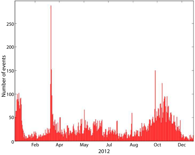 |
Figure 30. The number of seismic events registered per day at Turrialba during 2012. Courtesy of OVSICORI-UNA. |
Deformation. OVSICORI-UNA reported that during 2012 the distances between the Electronic Distance Measurement (EDM) station "Pilar" and several nearby reflectors contracted from 2 to 7 cm/year, with the highest value at the N reflector and lowest at the ENE and NE reflectors (see figure 31 for EDM station locations).
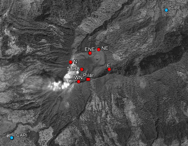 |
Figure 31. The location of geodetic monitoring stations at Turriabla during 2012. Red circles are reflectors of the EDM network, and measurements were made from the Pilar station (red square). Blue circles are permanent GPS stations (CAPI and GIBE). Courtesy of OVSICORI-UNA. |
Emissions. According to OVSICORI-UNA, the opening of the 2012 vent was not associated with new magmatic activity. Vent temperatures measured with a thermocouple were similar during 2010-2012, suggesting to OVSICORI-UNA a sustained and common magmatic source. Measured vent temperatures also correlated with CO2 and H2S gas emissions (figure 32).
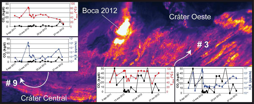 |
Figure 32. (Background image) Thermal image of Turrialba's W wall in Cráter Central (Central Crater) on 27 October 2012. Two vents are indicated, Boca 2012 (2012 Vent) and Cráter Oeste (West Crater). (Plots) For the measurement locations indicated by arrows, plots compare CO2 flux measurements (black) to both H2S flux measurements (blue) and thermal measurements acquired at 10-cm depth (red). Courtesy of OVSICORI-UNA; thermal photo taken by G. Avard. |
OVSICORI-UNA noted that gas emissions during 2012 had decreased considerably compared to those during 2010 and 2011. OVSICORI-UNA suggested that this decrease might be due to various factors, including a decline in rainfall that resulted in less water vapor, the primary component of the emissions. In a report discussing activity during January-February 2013, OVSICORI-UNA noted that the emissions from 2012 Vent had decreased, even though nighttime incandescence could be observed. Emissions drifted primarily NW during 2012.
Figures 33 and 34 summarize SO2 measurements from both miniature Differential Optical Absorption Spectrometer (mini-DOAS, fluxes) and OMI satellite data (masses). SO2 fluxes were lower than those in 2010-2011 when fluxes often reached above 1,000 tons/day (and in one case, nearly 4,000 tons/day; figure 34).
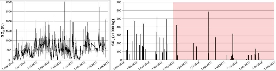 |
Figure 33. (Left) Daily SO2 flux (metric tons/day) at Turrialba measured by a mini-DOAS station at La Central school, ~2.2 km SW of West Crater, between 1 May 2012 and 1 January 2013. (Right) SO2 mass (uncorrected for any noise) emitted by Turrialba as recorded by NASA's Ozone Monitoring Instrument (OMI) aboard the AURA satellite during 2012. The SO2 mass corresponds to the total mass detected by the OMI sensor in the Central America area at 1800-1900 UTC. According to OVSICORI, both mini-DOAS and OMI measurements were consistent and of the same magnitude. The red-shaded area in the satellite data represents the time period corresponding to that of the mini DOAS data. Courtesy of OVSICORI-UNA and NASA-OMI. |
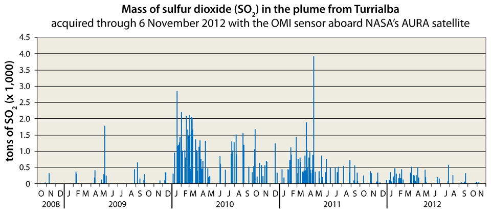 |
Figure 34. SO2 mass emitted by Turrialba as recorded by NASA's OMI instrument aboard the AURA satellite between 1 October 2008 and 6 November 2012. These represent masses in the atmospheric column that are thought to have roughly 1 day residence times. Courtesy of NASA-OMI. |
As in previous years, rain and fog absorbed volcanic gases in 2011 and 2012, producing acid rain with consequent damage and destruction to vegetation, especially in downwind areas in the sector sweeping clockwise from SW to N from the vents (figure 35).
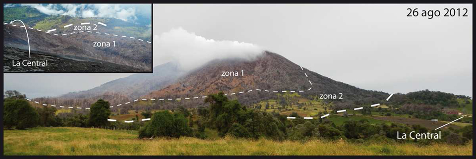 |
Figure 35. Annotated photo of Turrialba taken on 26 August 2012. The vegetation on the top and on the flanks of the edifice (zone 1) showed severe effects such as necrosis. The pasture vegetation (zone 2), used for milk production, turned yellowish (chlorosis). Interestingly, part of the native vegetation such as the tall trees (Quercus species) showed a stronger resistance to environmental acidification. Courtesy of OVSICORI-UNA; photo taken by G. Avard. |
OVSICORI-UNA observed that hydrothermal activity modified the mineralogy and decreased the cohesion of the rocks in contact with the fluids, which alter and reduce the stability of the slopes of the volcanic edifice, triggering gravitational collapses, rockfalls, and strong erosion during the main rain events. These phenomena were especially observed after storms on 15 August and in November 2012, when coarse and fine material was transported from the walls to the bottom of Central Crater, deepening the W and NW gullies.
In an M.S. thesis, Rivera (2011) compared SO2 concentrations in Turriabla's volcanic plume using a ground-based mini-DOAS and three new data analysis techniques using NASA's OMI instrument. The three new techniques were the MODIS smoke estimation, OMI SO2 lifetime, and OMI SO2 transect techniques. All four techniques involve UV sensor analysis. She found that the OMI SO2 lifetime technique provided qualitative agreement between the ground-based and satellite-based data, while the OMI transect technique provided occasional quantitative agreements with the mini-DOAS measurements. The MODIS smoke estimation technique was inaccurate in estimating SO2 emission rates.
Reference. Rivera, A.M., 2011, Comparisons between OMI SO2 data and ground-based SO2 measurements at Turrialba volcano, M.S. Thesis, Michigan Technological University.
Information Contacts: Observatorio Vulcanologico Sismologica de Costa Rica-Universidad Nacional (OVSICORI-UNA), Apartado 86-3000, Heredia, Costa Rica (URL: http://www.ovsicori.una.ac.cr/).
29 October 2014 magmatic eruption, the first such event in 150 years
This report primarily summarizes activity during January 2013 through mid-December 2014 (although a plot of SO2 flux during 1 October 2008-30 November 2013 is also presented). That activity included frequent gas emissions, occasional increases in seismicity, intermittent gas explosions that generated ash plumes and ashfall, and strong gas explosions on 21 May 2013 and 29-31 October 2014. Material here are primarily extracted from a 2013 annual report and the suite of 2014 monthly reports, all prepared by the Observatorio Vulcanologico y Sismologico de Costa Rica-Universidad Nacional (OVSICORI-UNA).
Recent Bulletin reports (BGVN 37:06 and 38:02) indicated that the number of volcanic earthquakes and degassing events at Turrialba's W crater during 2012 were lower than those in 2010 and 2011. The three main fumaroles present in the W crater were as follows: Boca 2010 on the W wall, Boca 2011 on the N wall, and Boca 2012 on the E wall.
Gas data, 2008-early 2013. Ultraviolet spectral analysis can yield estimates of volcanogenic SO2. The methods to assess and express volcanogenic SO2 vary, with some methods looking at the atmospheric column (total column mass) and others the flux of the gas close to the volcano (mass per unit time, for example, metric tons per day).
The Ozone Monitoring Instrument (OMI) travels in space onboard NASA's Aura satellite and yields estimate of the column SO2 mass. For Turrialba during the 2008-2013 period OMI determined SO2 mass burdens generally below 1,500 metric tons and in a few cases to higher values including two cases in the range 2,500-4,000 metric tons (figure 36).
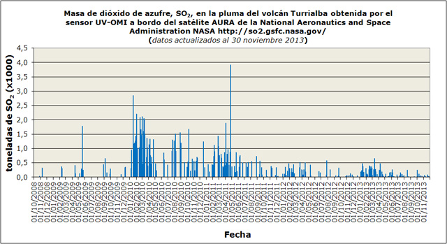 |
Figure 36. OMI satellite retrievals for SO2 masses in the atmospheric column during 1 October 2008-1 November 2013. Headers are in Spanish (unchanged from original source): Y-axis is SO2 mass in thousands of metric tons, X-axis is date (dd/mm/yyyy). Note the use of commas on the X-axis scale in the place of decimal points (0,5 = 0.5). Graphic is directly from the 2013 annual OVSICORI-UNA report (p. 6). |
During 1 April 2013 to 27 November 2013, the ground-based differential optical absorption spectroscopy (DOAS) stations near Turrialbal recorded fluxes generally between 500-1,000 metric tons/day. Based on the DOAS observations, OVSICORI-UNA plotted the CO2 / SO2 molar ratio. After an explosion on 21 May 2013, the observatory found this ratio generally increased progressively in available data during the nearly six months that followed (figure 37). In a similar manner, the H2S / SO2 molar ratio also showed a tendancy towards progressive increase in available data (figure 38).
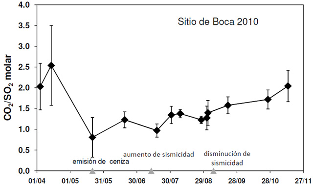 |
Figure 37. CO2/SO2 molar ratios at the Boca 2010 vent from DOAS measurements at Turrialba in the interval from 1 April 2013 to 27 November 2013. DOAS stands for Differential Optical Absorption Spectroscopy, measurements made by stations at the volcano. Spanish labels (left to right): ash emission, increase in seismicity, decrease in seismicity. Courtesy of OVSICORI-UNA. |
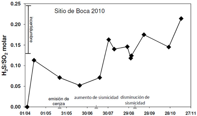 |
Figure 38. H2S/SO2 ratios between 1 April 2013 and late November 2013 at Turrialba's Boca 2010, as measured by DOAS stations. Spanish-language labels correspond to triangles on the X-axis stating, from left to right: "ash emission," "increase in seismicity," and "decrease in seismicity." Note error bar (incertidumbre) at upper left. Courtesy of OVSICORI-UNA. |
2013 events and monitoring. According to OVSICORI-UNA, the year 2013 began with low seismic activity (shallow hybrid earthquakes) and weak gas emissions similar to those in 2012. In March and April 2013, volcano-tectonic earthquakes originating more than 5 km below the summit began to occur, along with the first tornillo earthquakes of the year. (Tornillo-type earthquakes are long period with wave forms that, at or near the start, contain higher amplitude signals that gradually decrease with time. Their shape on seismograms resembles a woodscrew.) The number of volcanic earthquakes increased from 10/day on 18 April to more than 500/day on 13 July. This high level persisted until the end of August 2013.
On 20 May 2013, increased gas emissions produced a sky-blue plume visible from nearby areas. At 0452 on 21 May, the number of hybrid earthquakes became numerous. Continuous harmonic tremor increased at 0720. At 0830 and after 1100, explosions from both Boca 2010 and Boca 2012 vents generated ash plumes that rose more than 500 m (figure 39). Ashfall was reported in nearby communities to the N, W, and WSW. At noon on 21 May 2013, ash emissions ceased and seismicity decreased. Seismic activity declined sharply after the 21 May explosions, as did the CO2 /SO2 ratio, as measured in situ by a portable Multigas station. As previously noted (figures 37 and 38), for plotted measurements, the CO2/SO2 and H2S/SO2 ratios tended to progressively rise during the months that followed.
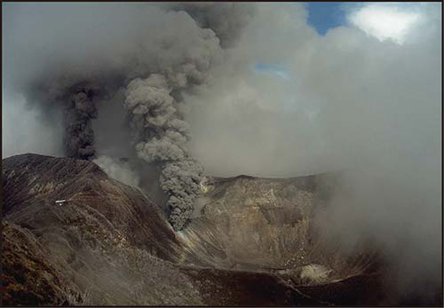 |
Figure 39. Gas explosions on 21 May 2013 at Boca 2010 and Boca 2012 on Turriabla's W crater. Photo taken by the webcam OVSICORI-UNA-A. Courtesy of OVSICORI-UNA. |
OVSICORI-UNA reported that a pilot flying past Turrialba about 40 km away observed a blackish plume on 29 May 2013. Officials from the Parque Nacional Volcán Turrialba observed a gas plume that was slightly darker than usual between 0730 and 0745; however, seismic records showed no abnormal activity at those times or seismic data signifying the discharge of a plume during the previous 48 hours. In addition, web camera images lacked evidence of ash emissions since 23 May. Gas plumes with temperatures more than 750°C were emitted from the two vents. The plume from Boca 2010 was whiter than the plume emitted from Boca 2012.
On 4 June 2013, light ashfall was reported in Pacayas (about 13 km W) and San Pablo in Oreamuno de Cartago (25 km SW). An observer in the previously closed National Park engulfing Turrialba noted that gas emissions that day were slightly stronger and more grayish than usual.
According to OVSICORI-UNA, seismic activity increased significantly again on 13 July 2013 with low-frequency signals (figure 40). On that day, the number of seismic events increased to more than 500/day. Seismicity remained at this level until late August when it decreased. During this period the gas temperature from Boca 2012 decreased from ~800°C to ~600°C. During 18-19 July, low-frequency tremor was detected. No morphological changes at the surface were observed.
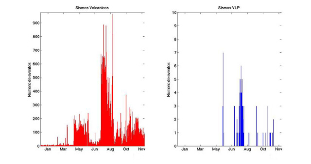 |
Figure 40. As recorded at Turrialba between January-November 2013, the number of volcanic earthquakes (y-axis on plot at left) and the number of very long period (VLP) earthquakes (y-axis on plot at right). Courtesy of OVSICORI-UNA. |
Volcanic earthquakes with very long periods ceased in November 2013. Tornillos also became less frequent.
2014. The 29 October magmatic eruption discussed below culminated years of high gas emissions at Turrialba. The eruption was sudden and impulsive, termed an explosion by OVSICORI-UNA, but was led by ongoing ash-bearing emission and a clear multihour escalation in tremor. No human injuries were reported. Costa Rica has bolstered its hazard infrastructure in recent years. According to GFDRR (2012) the legislation called the "Emergencies and Risk Prevention Law (No. 8488) requires Government agencies and municipalities to allocate resources for disaster risk reduction activities in their programs and budgets. Presidential Decree (No.36721-MP-PLAN) enhanced the risk management competencies of the CNE [the National Risk Prevention and Emergencies Management Commission] and provides a model to assess vulnerability (compulsory in governmental planning processes)."
During January-September 2014, the number of volcanic earthquakes often remained relatively low (under 100, figure 41, left plot). Occasionally the number approached 200. The low seismicity was broadly similar to that in the last half of 2013; the majority of earthquakes were of low magnitude, including those of tornillo, volcanic-tectonic, and hybrid affinities. During January-September 2014, volcano-tectonic (VT) seismicity was generally stable (at 3 or fewer events per day)(figure 41, right plot).
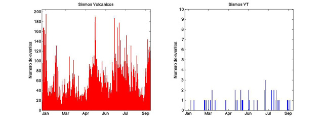 |
Figure 41. The number of daily seismic events at Turrialba during 1 January 2014-30 September 2014. Courtesy of OVSICORI-UNA. |
On 28 July 2014, a swarm of small, low-amplitude, short-duration, and high-frequency events lasted two hours. OVSICORI-UNA attributed the swarm to movement of fluids through cracks.
Conde and others (2014a) published an article about volcanic SO2 and CO2 fluxes at Turrialba during early 2013. They discussed SO2 and CO2 measurement methodologies used at Turrialba and Telica. OVSICORI-UNA reports during January-March 2014 noted the development of significantly more accurate, continuous ground-based SO2 monitoring. In addition, OVSICORI-UNA acquired and used an additional instrument, a Flyspec (a mini-spectrometer to measure SO2 levels). According to the OVSICORI-UNA September 2014 monthly report, SO2 fluxes in 2014 through September ranged from 400 to 1,500 metric tons/day, well below the maximum ~3,500 t/d they recorded during several days in June-August 2009 (Conde and others, 2014b).
In addition, reported CO2/SO2 ratios were ~8 in May, 2-4 in June, and ~2.5 in July 2014. H2S/SO2 molar ratios were ~1.2 in May and 0.2-0.7 in June 2014. Several authors in the two cited articles by Conde and others are affiliated with the NOVAC project (Network for Observation of Volcanic and Atmospheric Change). According to its website, the main objective of NOVAC is to establish a network for the measurements of volcanic gas and aerosol emissions--in particular SO2 and BrO--and to use the data from this network for risk assessment and volcanological research, both locally and on a regional and global scale. OVSICORI-UNA is part of the NOVAC consortium.
The temperatures at the W crater vents during January-July 2014 were about 600°C or lower, similar to the values of the previous six months as measured 15-20 m from the vents. In August and September, temperatures rose slightly to ~650°C; the composition of the gases were stable and interpreted as primarily magmatic.
Deformation in the August and September 2014 OVSICORI-UNA reports was determined by using interferometric synthetic aperture radar (InSAR), Global Position System (GPS), and electronic distance meter (EDM) surveys. According to the August 2014 report, the InSAR and EDM measurements showed, in the 2013-2014 time interval, a relative contraction of several centimeters around the E and W craters. The September 2014 OVSICORI-UNA reported that a GPS survey on a 4-point transect from the base of the volcano to the summit yielded preliminary results indicating that one of the stations (VTQU, on the S flank) had sunk 2-3 cm/year since 2011. The September 2014 report did not report deformation at other stations.
According to OVSICORI-UNA, seismic activity, which had been low earlier in the year, began to increase in late September 2014. In mid-October instruments recorded a three-day swarm of volcano-tectonic earthquakes. The largest event, M 2.8, occurred at 2035 on 16 October at a depth of 5 km beneath the active crater. SO2 flux remained low to moderate ranging between 400 and 1,500 metric tons per day during through October 2014. Magmatic influenced degassing intensified during 28-29 October; the SO2 flux was ~2,000 t/d, higher than the 1,300 t/d average measured in September 2014 and the highest to date during 2014. (Recalling the previously mentioned interval 1 April-27 November 2013, the recorded fluxes also stood lower, generally in the range 500-1,000 tons/day).
The 30 October report by OVSICORI-UNA, which contains informative graphics omitted here, including photos of the plume, tephra deposited on a car, seismic instrument records and spectral information, a helicorder record for a 24-hour interval bracketing the explosion). OVSICORI-UNA described the eruption on the 29th as a moderate eruption of ash between 2310 and 2335 (25 munutes).
According to that report, tremor began at 0600 on the 29th and continued unbroken into at least early the next day. The tremor and the associated RSAM escalation was sufficiently ominous as to lead OVSICORI to notify locals of the situation (including the CNE, the National Park, as well as a nearby lodge. The same OVSICORI-UNA report added that at unstated time during this episode the lodge's chief Tony Lachner noted the plume was darker than usual, contained a yellowish tinge, and was judged to contain ash. At 1700, OVSICORI-UNA again informed local authorities on the situation. The tremor had increased in amplitude and continuity (duration) during the afternoon. Tremor became strongest around 2310-2320 on the 29th coincident with the strong explosion then. The same report noted that OVSICORI-UNA had alerted aviation authorities of the explosion around midnight.
The explosion, heard by local residents, also left a clear record on instruments in the region including those at Poas and Irazu. The explosion ended what started as an initially small eruption from the West Crater that lasted about 25 minutes. The explosion was heard by nearby villagers. An ash cloud rose to an altitude of 5.8 km and drifted WSW. Ash fell on numerous nearby communities, including parts of the capital of San José (whose outskirts are ~30 km W) and Heredia (centered less than 40 km WNW of the volcano). In more detail, settlements noted by OVSICORI-UNA included San Gerardo de Irazú, San Ramón de Tres Ríos, Coronado, Moravia, Curridabat, Desamparados, Aserrí, Escazú, Santa Ana, Belén, Guácima de Alajuela, Río Segundo de Alajuela, San Pedro Montes de Oca, Guadalupe, areas of Heredia, and the capital of San José (population ~350,000, with central downtown located~ 70 km SW of Turrialbla).
The explosion on the 29th destroyed the wall between the West and Central craters, depositing material around the Central Crater and partially burying it. According to a news report (Agence France-Presse), Turrialba National Park remained closed, and eleven people from Santa Cruz de Turrialba were evacuated to shelters. Some schools were also temporarily closed, affecting over 300 area students. OVSICORI-UNA literature (including the 30 October report discussed above) noted that magma had not previously reached the surface at Turrialba since an eruption in 1866 (~150 years ago).
The magmatic eruption continued during 30-31 October (figure 42) with growing magmatic components seen in samples. Analyses of tephra showed that the proportion of juvenile material increased during 30 and 31 October, respectively, rising from the range of 3-5% by volume to the range of 7-10% by volume. A 30 October OVSICORI-UNA report noted that the ash dispersion modeling assumed a plume height of 1.5 km, consistent with a photo they showed (time unstated), which showed much of the plume remaining comparatively low in the area of view near the volcano. According to the Washington Volcanic Ash Advisory Center (VAAC), the 30-31 October eruption produced a continuous emission of gas and light ash with an occasional burst of heavier ash, generally moving W and SW.
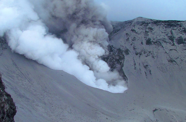 |
Figure 42. A photo of emissions at Turrialba's West Crater on 31 October 2014. The photo was taken from the tourist vista point at Turrialba Volcano National Park. The image shows two distinct plumes adjacent each other, a dark ash-bearing plume and a white plume rich in condensed steam. The plumes rose ~1 km above the vent. Courtesy of Raúl Mora (National Seismological Network, RSN, and University of Costa Rica). |
In their 7 November 2014 report, OVSICORI-UNA discussed how named staff collected and ran tests on leachate acidity for material deposited in the explosions during 29-31 October. Leachate reached pH 3.3 (highly acidic). In contrast, ash erupted during 4-5 January 2010 yielded leachate with pH 6.7-7.1 (near neutral). The 2014 report cautioned that such values were of considerable concern to human health, to environmental impacts (native vegetation, aquatic species, etc.), to cultivated plants, and to the well being of livestock and farm animals. The authors attributed the low pH values to the magmatic nature of the eruption and to absorption of those gases on the ash particle surfaces.
An explosion at 0520 on 1 November 2014 generated an ash plume that drifted toward the E and N parts of the Central Valley. A 3 November report stated that during the previous 24 hours seismicity had decreased significantly and no explosions had been detected; seismicity remained elevated. An phone and online (Facebook) public survey allowed residents to record if they had observed ashfall in their localities during the eruptive interval. Responses depicted a W-directed dispersal pattern that covered much of the urban area around San Jose.
OVSICORI-UNA reported a seismic signal indicating a strong emission lasting 50 minutes that started at 2320 on 6 November. The same 7 November report noted that in broad terms seismicity had decreased overall during the previous few days.
An ash-bearing explosion from Turrialba started at 1926 on 13 November and lasted about 10 minutes. Another explosion occurred at 1342 on 14 November and lasted about 15 minutes, although the strongest part was 7-minutes long. The OVSICORI-UNA report issued at 1635 on the 14th emphasized the associated explosive signal of these two emissions in terms of seismicity, for example, noting the dominant frequencies for the respective events were centered at 6.8 and 4.0 Hz. The report also said that of National Park officials reported ashfall at the top of Irazú. Volcanologists observed the 14 November explosion and collected samples at Hacienda La Central, 3 km SE of West Crater.
According to news reports (The Tico Times and crhoy.com), OVSICORI-UNA reported a strong gas emission on 13 November, accompanied by a massive outpouring of ash. A pilot reported ash plume S of the volcano at an altitude of 3.7-4.3 km.
According to OVSICORI-UNA, a strong Strombolian explosion occurred at 2128 on 8 December 2014, considered by them as one of the large explosions in the series that started with the magmatic eruption on 29 October 2014. The explosion lasted about ten minutes and had no precursory activity. The main pulse of ash emissions took place in under 100 seconds. Ashfall, 1 cm thick, and ballistics up to ~5 kg were deposited as far as 300 m W. Ashfall of 0.01 to 2 cm thickness was reported in the Central Valley and in towns to the W and SW, with 23 reports from citizens consistent with ash at distances of 45-80 km from the source. The report also noted constant inflation at Turriabla, ~10-15 mm annually, since the year 2010.
Citizen input to acquire ash thickness data. The Turriabla reporting took advantage of an OVSICORI questionare (Encuesta Alcance de Cenizas, V. Turrialba) to engage citizen observations on ash deposition. The online questionnaire (find link in "Information Contacts" section below) features a scalable map that features a positionable icon to show the location of ash-thickness observation. This position then automatically computes the resulting coordinates (latitude and longitude). The questionare includes several other questions relating to thickness, date and time of observation, rainfall, and weather conditions (which can perturb the original thickness). Entering contact information is optional.
References. Conde V., Robidoux, P., Avard, G., Galle, B. Aiuppa, A.,? Muñoz, A., and Giudice, G., 2014a, Measurements of volcanic SO2 and CO2 fluxes by combined DOAS, Multi.GAS and FTIR observations: a case study from Turrialba and Telica volcanoes, Int J Earth Sci (Geol Rundsch), 103, pp. 2335-2347, Springer-Verlag, Berlin Heidelberg. (Also Errata November 2014, 103 (8), p 2349.)
Conde, V., Bredemeyer, S., Duarte, E., Pacheco, J., Miranda, S., Galle, B., and Hansteen, T., 2014b, SO2 degassing from Turrialba Volcano linked to seismic signatures during the period 2008–2012, International Journal of Earth Sciences (Geol Rundsch) 103, pp. 1983–1998, Springer-Verlag, Berlin Heidelberg.
GFDRR, 2012, Costa Rica Country Update – GFDRR, October 2012; Global Facility for Disaster Reduction and Recovery (GFDRR). (URL: http://www.gfdrr.org/sites/gfdrr.org/files/COSTA_RICA.pdf) (Accessed 12 July 2015).
Information Contacts: Observatorio Vulcanologico y Sismologico de Costa Rica-Universidad Nacional (OVSICORI-UNA) (URL: http://www.ovsicori.una.ac.cr/); Washington Volcanic Ash Advisory Center (VAAC), Satellite Analysis Branch (SAB), NOAA/NESDIS E/SP23, NOAA Science Center Room 401, 5200 Auth Rd, Camp Springs, MD 20746, USA (URL: http://www.ospo.noaa.gov/Products/atmosphere/vaac/); Network for Observation of Volcanic and Atmospheric Change (NOVAC) (URL: http://www.novac-project.eu/); The Tico Times (URL: http://www.ticotimes.net/); Agence France-Presse (URL: http://www.afp.com/); The Costa Rica Star (URL: http://news.co.cr/); and crhoy.com (URL: http://www.crhoy.com/).
Persistent explosions and ash emissions during 2015 and 2016
Strong fumarolic activity characterized activity at Costa Rica's Turrialba for several decades before a phreatic eruption in January 2010 resulted in ashfall tens of kilometers from the volcano. Since the January-March 2010 eruption, there have been one or two brief eruptive episodes with ash emissions each year, generally lasting days to weeks. An episode from 29 October through 8 December 2014 began with an ash explosion, followed by continuous emissions on 30 and 31 October. Several additional explosions with ash emissions occurred during November, followed by a strong Strombolian explosion on 8 December that included ashfall up to 1 cm thick in places, and ballistics deposited 300 m from the vent (BGVN 40:04). This report covers the increasing ash-emission activity during 2015 and 2016. Information comes primarily from the Observatorio Vulcanologico y Sysmologico de Costa Rica-Universidad Nacional (OVSICORI-UNA). Aviation alerts are issued by the Washington Volcanic Ash Advisory Center (VAAC).
Turrialba began a new eruptive episode with an ash plume on 8 March 2015. Frequent, intermittent ash-bearing events continued through mid-May, and tapered off during June, with a final event reported on 22 June 2015. The larger plumes rose 2-2.5 km above the vent rim and drifted in many different directions, leading to ashfall throughout the region as far as 40 km from the volcano. A 'bubble of magmatic gas' dispersed accumulated ash from the vent on 15 August 2015. An eruption on 16 October 2015 was the largest in a year, and the start of a new series of emissions that persisted through the end of October, dispersing ash for tens of kilometers in most directions. A brief period of ash emissions between 2 and 8 February 2016 deposited ash within a few kilometers of the summit crater. Ash emissions and frequent small explosions between 28 April and 7 May preceded a longer series of emissions that began with a significant explosion on 16 May, included significant ashfall in regions within 30 km, and lasted until late July 2016. Strombolian activity and pyroclastic flows were also reported during late May; ashfall was reported up to 100 km SW. A new series of explosions and ash emissions began on 13 September that continued nearly uninterrupted through the end of the year, although ashfall reports were greatest in October 2016.
Activity during 2015. Little activity was reported during January and February 2015. Seismicity slowly increased from short-duration, low-amplitude, higher-frequency events in January to more lower-frequency events in February. Very-long-period earthquakes (VLP's) began to register in February and became more pronounced during March, when some were associated with explosions and ash emissions. The first, short, effusive emissions with low ash content occurred on 8 March. The largest events with prolonged ash emissions occurred on 12 (figure 43) and 15 March.
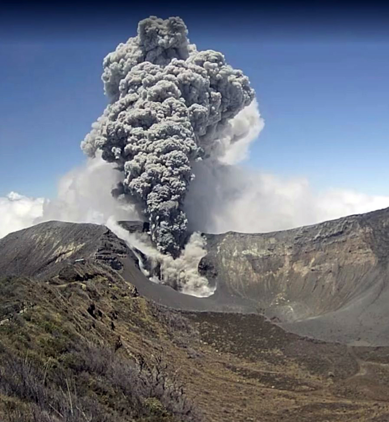 |
Figure 43. Eruption at Turrialba on 12 March 2015. Webcam image courtesy of OVSICORI (Boletín de Vulcanología Estado de los Volcanes de Costa Rica, January, February, March 2015). |
Based on webcam views, weather models, and OVSICORI-UNA updates, the Washington VAAC reported that on 8 March diffuse ash emissions rose from the Cráter Oeste (West Crater) and seismicity increased. OVSICORI-UNA reported more ash emissions on 11 and 12 March. Almost continuous ash emissions were observed in the afternoon of 12 March punctuated by two noticeable explosions. Ash plumes rose as high as 2 km above the crater and drifted NW. Ashfall also occurred in the Valle Central and in the capital of San José (30 km WSW), and caused the closure of the Juan Santamaria International Airport (48 km W), which reopened during the evening on 13 March. The local Tobias Bolanos airport (40 km WSW) closed intermittently. On 13 March three short-duration explosions were reported. According to the Washington VAAC, ash plumes that day drifted 45 km NE at an altitude of 9.1 km, and drifted over 35 km W at an altitude of 6.1 km.
On 18 March, OVSICORI-UNA reported that gas, vapor, and ash plumes rose from Cráter Oeste and seismicity remained high. Observers in Finca La Central (2 km SW) noted gas-and-steam emissions. On 19 March two gas-and-water-vapor emissions were observed; one from Cráter Central contained a small amount of ash. At 1400 the webcam recorded strong emissions of gas, vapor, and tephra from Cráter Oeste. On 23 March a gas, vapor, and ash plume rose from Cráter Oeste, causing ashfall in areas E and SE of the crater including in the Cráter Central and El Mirador. In addition, a dense and vigorous gas-and-vapor plume caused Parque Nacional Volcán Turrialba authorities to recommend masks for protection against gas inhalation.
There were 11 gas-and-ash eruptions and 10 additional smaller ash emissions during April 2015. OVSICORI-UNA reported that a small ash eruption occurred on 3 April, causing ashfall in nearby areas including Silvia and La Central. On 5 April, an eruption generated a plume that rose 500 m and caused ashfall in Curridabat (31 km WSW), Granadilla (29 km WSW), San Pedro, Desamparados (35 km WSW), Aserrí (40 km SW), San Sebastián (37 km WSW), and Escazú (42 km WSW). The eruption of 7 April was the largest of the month (figure 44), and although it occurred at night, the visible ash plume rose to about 2.5 km above the summit. Ash and sulfur odors were reported in many areas of the city of San José (30-40 km WSW). The largest quantities of ash fell in the La Picada and La Silvia communities a few kilometers NNE of the volcano, and affected several hundred cows and other animals at dairy farms. Small ash emissions occurred on 8, 16, and 18 April, and every day during 20-24 April. The ash on 20 April dispersed N and affected Guápiles (20 km N). On 23 and 24 April, ash dispersed NW and affected the inhabitants of the Valle Central, and was reported at Tobias Bolanos and San Juan Santamaria international airports.
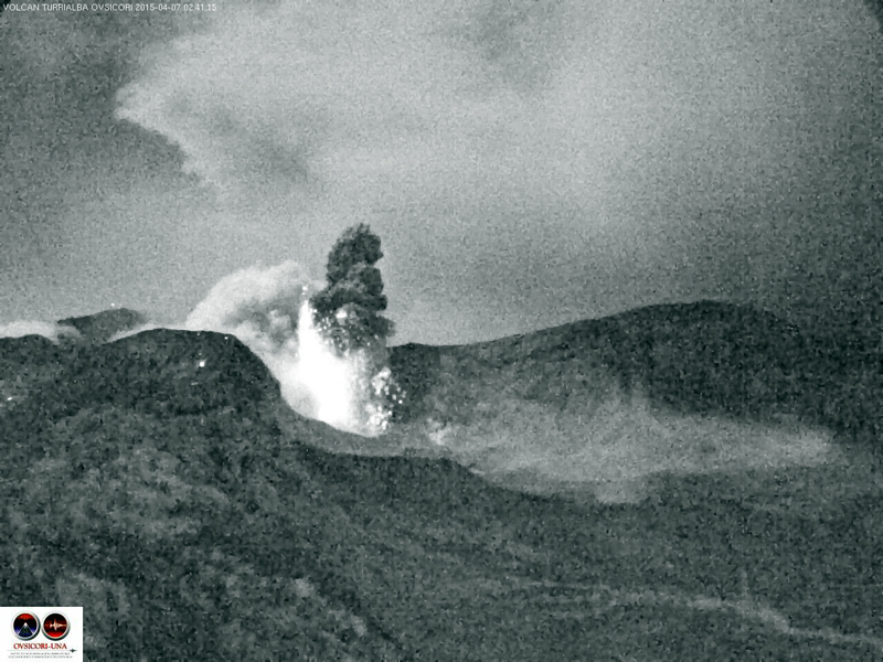 |
Figure 44. Nightime eruption of ash and hot volcanic blocks from Turrialba on 7 April 2015 that began at 0205 and lasted until 0241. Webcam image courtesy of OVSICORI-UNA, (Boletín de Vulcanología, Estado de los Volcanes de Costa Rica, April 2015) |
During May 2015, OVSICORI-UNA recorded 39 eruptions with ash emissions. In general, the plumes did not rise more than 500 m above the crater, and a few were accompanied by small pyroclastic flows. The largest events were on 1 and 4 May when emissions lasted for 4 and 23 minutes, respectively. The 4 May event produced an ash plume that rose 2.5 km and drifted SW. The eruption ejected ballistics 1 km from the crater. Most of the ashfall occurred around the crater. Reports of minor ashfall and sulfur odors came from communities 30-40 km WSW around the city of San José (Moravia, Coronado, Mata de Plátano, La Uruca, Guadalupe, Tibás, Calle Blancos, San Pedro Montes de Oca, Sabanilla Montes de Oca, Pavas, Zapote, Escazú, Paso Ancho, Curridabat, Santa Ana), and a few localities in the eastern region of Heredia (40 km W). Additional ash emissions were reported on 6, 11, 14, and 18 May. Although the multiple emissions on 18 May lasted as long or longer than earlier events (23 and 25 minutes), they were lower energy, and the plumes rose only 400-500 m above the summit crater.
OVSICORI-UNA reported that ash emissions occurred on 1, 4, 7, and 22 June 2015. The eruption on 1 June was the largest, and the small ash eruption on the afternoon of 22 June deposited ash mainly in the vicinity of the volcano to the SW (figure 45). They also reported a significant decrease in the seismic activity, such that by late June, the RSAM values had returned to levels similar to October 2014, prior to the start of the most recent eruptive events. Significant rains after April 2015 led to a shallow lake forming in the Cráter Oeste. Images taken in July of the Cráter Central showed deposits of eruptive material more than 2 m thick compared with May 2014.
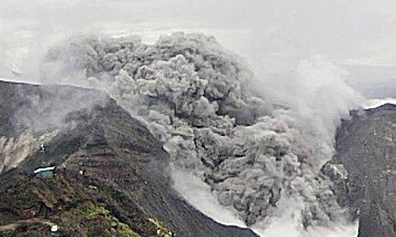 |
Figure 45. Eruption at Turrialba on 22 June 2015. Webcam image courtesy of OVSICORI-UNA (Boletín de Vulcanología, Estado de los Volcanes de Costa Rica, June 2015). |
Seismicity continued to decrease during August 2015. However, an event on 15 August comprised nine hours of tremor associated with the ascent and escape of a bubble of magmatic gas, according to OVSICORI-UNA. The resulting ash ejection was believed to be material that had accumulated at the bottom of the crater. Seismicity remained low during September, with no reported ash emissions.
An increase in seismicity began on 1 October 2015, and until a large eruption on 16 October (figure 46). This was followed on 23 October by a lengthy sequence of ash emissions that continued until 31 October. The 16 October eruption was the largest in terms of energy since the 30 October 2014 eruption. Most of the ash fell on the summit, but a plume headed NW and minor ashfall was reported in parts of the Valle Central such as la Unión, Concepción de Tres Ríos, Montes de Oca (30 km WSW), San Rafael de Coronado (26 km WSW), and Moravia (27 km W). A strong odor of sulfur was reported in Tierra Blanca (18 km SW), Pacayas (12 km SSW), Moravia, and Guadalupe (32 km WSW).
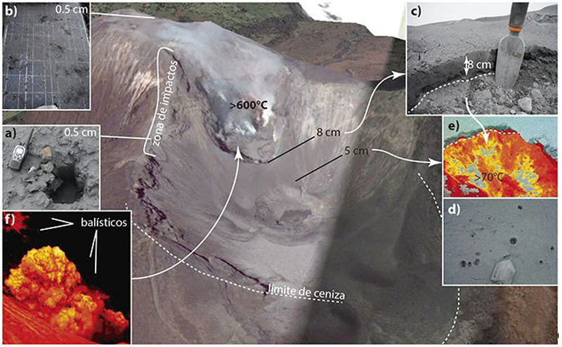 |
Figure 46. A Google Earth image of Turrialba annotated with images from the 16 and 26 October 2015 eruptions. a) 20-cm- diameter impact from volcanic ejecta. b) Solar panel destroyed by impacts. c) Ash deposit. d) Pyroclastic flow deposit. e) Hot material deposited by the pyroclastic flow. f) Thermal image of an eruption on 26 Of October (Photos: G.Avard). Courtesy of OVSICORI-UNA (Boletín de Vulcanología, Estado de los Volcanes de Costa Rica, October 2015). |
Seismicity increased between 16 and 23 October, when new ash emissions began and were accompanied by pyroclastic flows. Between 23 and 31 October, OVSICORI-UNA reported 57 small emissions and 120 explosions of varying size and characteristics. The Washington VAAC was unable to see most of the emissions in satellite imagery due to weather clouds, however the plumes on 31 October were reported at 4.3 km altitude moving W. Both seismic and eruptive activity declined considerably during November 2015. OVSICORI-UNA reported one small eruption on 27 November and a small explosion on 30 November; they did not mention ash related to either event.
Activity during 2016. OVSICORI-UNA reported a brief emission of gases and volcanic ash to 500 m above the crater on 2 February 2016. Residents of La Silva (2 km NW) reported a sulfur odor and ashfall on 5 February, and additional emissions above Cráter Oeste on 6 February. The Washington VAAC noted gray emissions on 8 February. The next report, on 3 April, described an explosion lasting less than one minute that generated a small gas-and-ash plume. Seismicity increased on 28 April, followed by ash emissions and frequent small explosions on 30 April and 1 May from Cráter Oeste. Gas-and-tephra emissions increased on 1 May with minor amounts of ash deposited in La Central (4 km SW) and La Pastora (6 km SSE). A larger ash plume on 2 May rose 2 km above the summit, and was followed by frequent explosions producing 1-km-high ash plumes the next day. Frequent explosions were again recorded during 3-5 May with ash plumes rising up to 1 km above Cráter Oeste. Small lahars were reported on 7 May, and small, frequent ash emissions accompanied spasmodic tremor on 8 May.
A significant explosion on 16 May 2016, that caused abundant ashfall on farms 2.5 km WNW, was the start of a new episode that lasted for more than two months. Frequent ash emissions continued the next day, although seismic tremor amplitude decreased substantially from the initial explosion. Numerous gas-and-ash emissions were reported during 17-19 May. Ashfall was reported in areas of Valle Central (30-40 km W), including Coronado, Guadalupe, and Heredia (38 km W). On 20 May a Strombolian phase began, producing an ash-and-gas plume that rose 3 km and drifted W. The eruptive column collapsed, generating pyroclastic flows that reached the nearby ranches of La Silva and La Picada, and the Cráter Central. According to a news article, some airlines canceled or delayed flights into the Juan Santamaría International Airport (48 km W).
Gas-and-ash emissions continued during 21-22 May; plumes rose as high as 600 m above the summit. Villagers reported ashfall in areas of San José (40 km WSW), Cartago (25 km SW), Alajuela (49 km W), Heredia (38 km W), Puriscal (65 km WSW), and Jaco (100 km SW). Ash plumes rose as high as 1 km and drifted W and SW on 23 May, causing ashfall in areas downwind including Tapezco (Zarcero-Alfaro Ruíz, 70 km WNW), Guácima de Alajuela (55 km WSW), Barva (39 km W), Finca Lara (17 km W), Finca Laguna (23 km WNW), Grecia, and Naranjo. A strong explosion on 24 May generated new ash plumes that rose 3.5 km and drifted SW. This event ejected large rocks around the crater and led to ashfall in multiple areas including Santa Rosa de Oreamuno, Santa Cecilia de Heredia, and San Francisco de Heredia, tens of kilometers to the W. Large amounts of ash (deposits 2-7 mm thick) fell in Carthage, Heredia (38 km W), San José (40 km W), and Alajuela (49 km W) from more explosions on 25 May that also ejected incandescent material.
A small explosion on 1 June 2016 began a new sequence of ash emissions, with plumes rising 1-2 km, that lasted until 4 June. Ashfall was reported in a number of communities including San Rafael de Moravia (31 km WSW), Sabana (38 km WSW), Buenos Aires (17 km N), and Pococí (45 km N) during 2-3 June. Ash emissions and explosions on 10 June caused ashfall and/or a sulfur odor in multiple areas of Valle Central including San Luis, Santo Domingo, Moravia, San Francisco, and Coronado. OVSICORI-UNA reported increased seismic activity on 16 June; the webcam showed areas of incandescence. Morning satellite imagery showed a diffuse ash plume extending 45 km WNW of the summit that dissipated by mid-afternoon. Tremor increased on 23 June, followed by a lengthy sequence of tremor episodes and ash emissions that lasted through 26 June; ashfall was reported in several neighborhoods in San José and Heredia. Increased tremor on 28 June was likely accompanied by ash emissions, but darkness and clouds obscured views from the webcam.
Strong tremor on 7 July 2016 was followed by an ash plume that rose 1 km above the crater and likely drifted WNW and WSW. Ashfall was recorded in many neighborhoods downwind, in San José, Heredia, and Turrubares. Emissions of large amounts of ash were visible in the webcam the next day, and ashfall was reported in many of the same areas as the day before. The Washington VAAC issued daily reports from 7 to 15 July of diffuse ash emissions observed in the webcam, generally rising less than 500 m above the summit. A new series of explosions during 22-25 July were recorded seismically, but visual observations were difficult due to fog. Hot rock fragments, gas, and ash were noted as high as 500 m above the crater on 24 July. Ash plumes rose to 3 km above the crater and drifted NW, W, and SW the next day. OVSICORI-UNA reported possible volcanic ash again on 29 July and 1 August, but weather clouds prevented views in satellite imagery.
Another new series of explosions and ash emissions began on 13 September 2016. They were reported daily from 15 September to the end of the month. Most plumes rose less than 1 km above the crater, but explosions on 19 September generated ash plumes that rose as high as 4 km and resulted in ashfall in many communities in the Valle Central, including those in San José (35 km WSW), Heredia (38 km W), Alajuela, and Cartago (25 km SW). According to news articles, flights in and out of the Juan Santamaría International Airport were canceled; the airport remained closed at least through the morning of 20 September. The Pavas San José Tobías Bolaños Airport in San José was also temporarily closed. Plumes that rose as high as 2 km were reported on 22, 26, and 27 September.
During a 22-24 September field visit OVSICORI-UNA scientists observed a significant lahar in the Rio Toro Amarillo which flows NW from Turrialba, that mobilized logs and large rocks in a 1.5-m-deep flow (figure 47). They had observed 3 cm of fresh ash in the drainage prior to the start of the rainfall on 22 September.
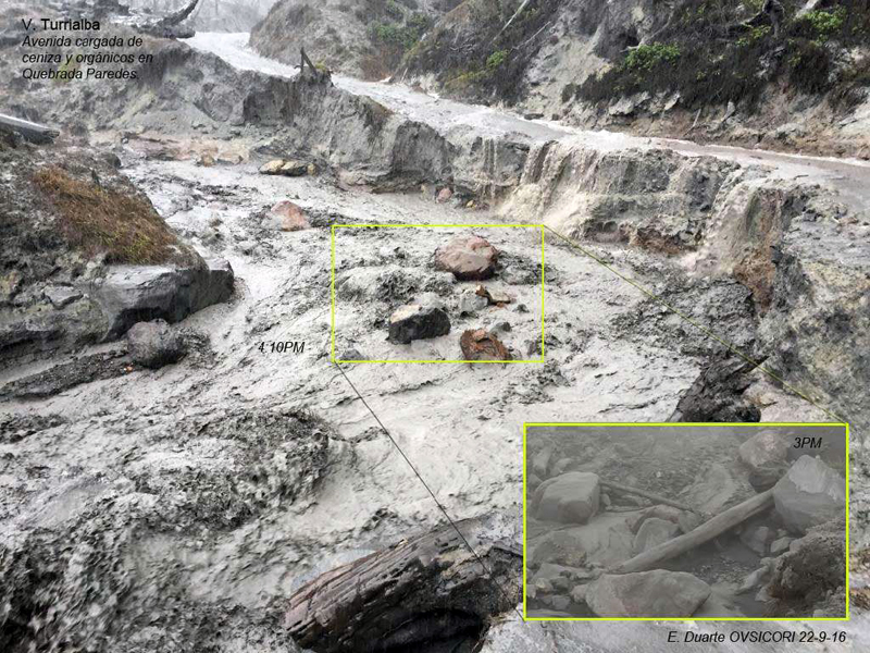 |
Figure 47. The abrupt change in flow conditions was observed by OVSICORI-UNA scientists on 22 September 2016 when heavy rains generated a lahar in the Rio Toro Amarillo at Turrialba. The inset photo shows the same area about an hour before the flooding. Photo by E. Duarte, courtesy of OVSICORI-UNA (Algunos Efectos Proximales y Distales por Acumulación de la Ceniza: Volcán Turrialba, Reporte de campo: 22-24 de setiembre de 2016). |
From 26 September through 24 November 2016 multiple reports were issued by the Washington VAAC virtually every day, usually reporting minor emissions of gas and ash. OVSICORI reported intermittent steam, gas, and ash emissions rising 500-1,000 m during all of October 2016. Ashfall was reported in Guadeloupe on 11 October. On 16 October OVSICORI-UNA noted that the almost constant ash emission in the previous few days affected the operation and communication of various scientific instruments installed at the top of the volcano and surrounding areas; communication with two seismic stations located near the summit was lost. Webcams showed continuing ash emissions rising as high as 1 km during 16-18 October. During 18-25 October, passive ash emissions continued, causing ashfall in Siquirres (30 ENE), Guacimo (23 km NNE), Guapiles (21 km N), Moravia (27 km W), San José (36 km WSW), Tibás (35 km WSW), Guadalupe (32 km WSW), Curridabat (32 km WSW), Tres Ríos (27 km SW), San Pedro (32 km WSW), and various areas of the Valle Central. Ashfall was reported in Nubes de Coronado (25 km W) on 28 October.
There were fewer reports of ashfall during November, although many areas of the Valle Central reported ashfall during 9-13 November. A small quantity of ash fell in Cartago and Paraiso de Cartago (25 km SE) on 20 November. The Washington VAAC again issued near-daily reports of ash and gas plumes between 6 December and the end of 2016. The weak and sporadic emissions generally rose only a few hundred meters, drifting in multiple directions, and there were few reports of ashfall in the surrounding communities.
Information Contacts: Observatorio Vulcanologico Sismologica de Costa Rica-Universidad Nacional (OVSICORI-UNA), Apartado 86-3000, Heredia, Costa Rica (URL: http://www.ovsicori.una.ac.cr/); Washington Volcanic Ash Advisory Center (VAAC), Satellite Analysis Branch (SAB), NOAA/NESDIS OSPO, NOAA Science Center Room 401, 5200 Auth Rd, Camp Springs, MD 20746, USA (URL: http://www.ospo.noaa.gov/Products/atmosphere/vaac/).
Persistent explosions and ash emissions continue through 2017; small lava lake
A phreatic eruption at Turrialba in January 2010 heralded a series of brief eruptions during subsequent years. Explosions and emissions containing ash increased in 2015 and 2016 (BGVN 42:06). The current report indicates that increased activity continued during 2017. The information below comes from the Observatorio Vulcanologico y Sysmologico de Costa Rica-Universidad Nacional (OVSICORI-UNA) unless otherwise indicated.
Frequent ash emissions, both passive and explosive events, rose the heights of less than 1 km above the crater and were blown downwind, causing ashfall in communities within about 40 km, and a sulfur odor at greater distances. Fumarolic plumes described as consisting of water vapor, aerosols, and magmatic gases were also common from the West Crater. Volcanic seismicity was variable, often corresponding to changes in activity.
Activity during January-June 2017. During the first part of January, no explosions took place. Based on webcam and satellite views, the Washington Volcanic Ash Advisory Center (VAAC) reported that on 22 January, an ash plume rose to an altitude of 4 km and drifted E. The VAAC reported ongoing ash emissions on 27 January.
On 1 February, OVSICORI-UNA reported that since 27 January the seismic network had recorded variable-amplitude, discontinuous tremor indicative of moving pressurized volcanic fluid. Passive emissions of ash were observed during 1-2 February, rising as high as 500 m above the crater. Ashfall was reported in the area of the capital, San Jose (about 37 km WSW), including Desamparados, Calle Blancos, and Tres Ríos (27 km WSW), and a sulfur odor was noted in San Pablo Heredia (35 km W). An explosion at 0900 on 4 February generated an ash plume that rose 300 m and drifted W. Almost continuous ash emissions rose at most 500 above the crater during 4-5 February and drifted WSW (figure 48).
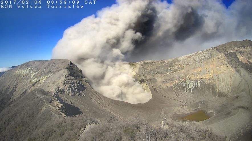 |
Figure 48. An ash explosion from Turrialba on 4 February 2017 at 1145, taken by an RSN camera at the summit. Courtesy of RSN:UCR-ICE (Resumen de la Actividad Sismica y Eruptiva del Volcan Turrialba, 03 de febrero de 2017). |
OVSICORI-UNA reported that at 1610 on 8 February, an ash plume rose 300 m and drifted N. An event at 1531 on 10 February also produced an ash plume, but inclement weather prevented observations. During 11-12 February, variable amplitude tremor was detected, and at night hot blocks ejected from the vent landed in Central Crater. Several events on 13 February (at 0255, 0305, 0415, and 1459) produced ash plumes that rose as high as 1 km and drifted N, NW, and W. Small ejections of incandescent material fell around the active crater during the early morning. On 14 February continuous emissions of gas and steam with low ash content were visible. A strong sulfur odor was reported in San Pablo de Oreamuno (25 km SW). High-amplitude tremor remained constant during 15-16 February and sporadic gas emissions with minor amounts of ash drifted S and E; occasional ballistics were ejected from the crater. During 16-17 February tremor amplitude decreased and sporadic gas emissions with low ash content rose no higher than 300 m and drifted NW and SW. Similar emissions were observed during 20-21 February, drifting NW and NE.
Weak gas emissions during 20-21 March sometimes contained small amounts of ash that rose no higher than 100 m above the crater rim and drifted SW. Volcanic tremor had medium and variable amplitude, and a few low-frequency (LF) earthquakes were recorded. A weak ash emission was visible during 1800-1940 on 25 March. Periods of more intense crater incandescence, from possible Strombolian activity, corresponded to higher tremor amplitude during 0330-0530 on 26 March. Later that day a small plume with minor ash rose 500 m above the crater and drifted S and SE. An event at 0752 on 28 March generated an ash plume that rose 300 m and drifted S.
Ash-and-gas plumes rose 500 m above the crater during 31 March-1 April, and ashfall was reported at the Juan Santamaría airport (48 km W). Ash plumes rose 500 m at 1700 on 2 April, and 200 m at 0601 on 4 April. A passive ash emission occurred on 16 April. An event at 0751 on 17 April generated a plume containing minor amounts of ash that rose 500 m above the crater and drifted SW. On 18 April, a diffuse plume consisting of gas and sometimes ash rose 1 km above the crater and drifted W.
An event at 1700 on 5 May generated a weak ash plume that rose 500 m above the crater and drifted SW. Two short-amplitude events occurred at 1702 and 1820, though it was uncertain if they were associated with an explosion. During 5-7 May volcano-tectonic (VT) and long-period (LP) earthquakes were detected, as well as variable-amplitude tremor. At 1250 on 6 May, an event produced a plume that rose 300 m and drifted W. Passive ash emissions occurred between 1250 and 1730 on 6 May, and at 1000 on 7 May, that rose no higher than 1 km. At 0902 on 9 May an event generated an ash plume that rose 500 m and drifted NW.
An explosion on 10 May was followed by weak and passive ash emissions. Several LP earthquakes were recorded, and inflation continued. Gas measurements indicated a sulfur dioxide flux of 1,000 tonnes/day, and a high carbon dioxide/sulfur dioxide ratio. An event at 0900 on 12 May generated a plume, though poor visibility prevented a height estimate. An event at 0730 on 14 May generated a plume that rose 500 m above the crater rim and drifted N. Low-amplitude tremor was detected during 15-16 May, and a discontinuous ash plume rose no more than 500 m and drifted N and NW.
Ash emissions observed during 17-23 May rose as high as 1 km above the vent. Ashfall was reported in El Tapojo and Juan Viñas (15 km SSE) during 17-18 May, and in Capellades (along with a strong sulfur odor) during 19-20 May. During 23-30 May, tremor amplitude fluctuated from low to high levels, often corresponding to emission characteristics; periods of VT and LP events were also recorded. During 24-26 May several passive ash emissions rose no higher than 500 m above the vent and drifted NW and SW. Frequent and small explosions during 26-27 May generated ash plumes that rose higher than 500 m above the vent and ejected material higher than 200 m and no farther than 100 m towards Central Crater. Small explosions during 27-29 May produced ash plumes that rose 300-500 m. Fumarolic plumes during 30-31 May occasionally contained ash that rose no higher than 300 m above the crater rim and drifted NW.
On 3 June at 1930 an event produced an ash plume that rose 300 m and drifted SW. During 7-13 June, tremor amplitude fluctuated from low to medium levels and periods of small VT events and many small-amplitude LP events were also recorded. Fumarolic plumes rose as high as 1 km above the vent and drifted mainly NW, W, and SW. Gas emissions during 14-15 June sometimes containing ash rose no higher than 300 m above the crater. Events at 0620 and 1405 on 16 June generated ash plumes that rose 500 m and drifted NW, and 200 m and drifted S, respectively. Passive ash emissions during 19-20 June rose as high as 1 km and drifted in multiple directions. During 20-25 June fumarolic plumes rose as high as 1 km above the crater; the gases were strongly incandescent the night of 22-23 June.
Drone observations on 29 June 2017. According to an RSN:UCR-ICE report and meeting abstract (Ruiz and others, 2017), government officials flew a drone over the volcano on 29 June 2017. The observations showed profound changes in the morphology of the active crater since a previous overflight on 30 March 2016. In March 2016, the active crater exhibited internal landslides, an accumulation of materials at the foot of the W wall, and a ring of fumaroles surrounding a small opening that constituted the point of ash emission. The active crater was narrow and had an oblong shape, with a longer axis in the E-W direction.
During the recent overflight, the active crater was deeper and wider, elliptical, with its longest axis in the SW-NE direction, coincident with the preferential direction of explosions. In the N and NE sectors of the crater floor ash and blocks had accumulated. The most significant feature of the crater's central sector was an opening with a major axis of about 50 m across from which incandescent material was observed; the group believed this incandescence originated in the small lava lake from which passive ash emissions or small explosions arise. The authors stated that lava was present on the crater floor, forming a small lava pool (15 x 25 m).
Activity during July-December 2017. During 29 June-11 July seismicity was characterized by low-to-medium amplitude tremor and a small number of low-amplitude VT and LP events. Fumarolic plumes and occasional ash rose as high as 1 km above the West Crater fumaroles. Incandescence from the main crater was recorded at night. Minor ashfall and a sulfur odor was reported in areas of San José including Rancho Redondo, Goicoechea, Moravia, San Pedro Montes de Oca, Guadalupe, and Coronado, and in San Rafael and Barva (Heredia). Parque Nacional Volcán Turrialba staff reported that ash was deposited between La Silvia and La Picada farms. Events at 1325 on 10 July and 1545 on 11 July generated plumes that rose 300 and 500 m above the crater rim, respectively.
Daily explosions over 12-17 July produced gas and ash plumes that rose 200-500 m and generally drifted NW, W, and SW. Multiple events on 15 July caused ashfall in Sabanilla de Montes de Oca (30 km WSW), Ipis (27 km SW), El Carmen de Guadalupe, Purral (26 km WSW), Guadalupe (32 km WSW), and Tibás (35 km WSW). A sulfur dioxide odor was also reported in San José (36 km WSW), Tibás, Guadalupe, Escazú (42 km WSW), and Puriscal (65 km WSW). During 19-24 July fumarolic plumes rose as high as 500 m, and on most nights incandescence emanated from West Crater. The emissions contained ash during 20-22 July; minor ash fell in Coronado (San José) on 20 July, and in Sabanilla de Montes de Oca on 22 July.
Events on 26 July, 9 August (1607), 21 August (1012), 24 August (0715), 28 August (1025), 5 September (0820 and 1550), 11 September (0730), 13 September (0820 and 1555), 14 September (0600), 18 September (0703), 25 September (1112), and 26 September (0910) produced plumes that rose 100-500 m above the crater rim and drifted NW, SW, N, and W.
During 27 September-1 October and on 3 October, daily events generated plumes that rose as high as 1 km above the crater rim and drifted NW, W, SW, and S. On 30 September explosions ejected hot material out of West Crater and minor ashfall was reported in Coronado (San José). On 3 October, ash fell in Santa Cruz (7 km SE), Las Verbenas, Santa Teresita, Calle Vargas, Guayabito, and La Isabel.
Events on 6 October (0815), 9 October (1040), 11 October (0927), and 20 October (0825) produced plumes that rose 50-300 m above the crater rim and drifted NW and N. Events at 1030, 1105, and 1445 on 30 October generated ash plumes that rose 200-500 m above the crater rim and drifted NW, W, and SW. Ashfall was reported in the community of Pacayas (about 12 km SSW).
The Washington VAAC reported that an ash emission was observed in webcam images on 4 November; ash was not identified in satellite images, though weather cloud cover was increasing and may have obscured views. According to OVSICORI-UNA, another ash emission began before 0730 on 13 November and intensified around 0830, generating an ash plume that rose 500 m above the crater rim and drifted SW. A small event at 1319 on 1 December generated a weak ash plume that rose 50 m above the crater rim and drifted SW.
Reference. Ruiz, P., Mora, M., Soto, G.J., Vega, P., Barrantes, R., 2017. Geomorphological mapping using drones into the eruptive summit of Turrialba volcano, Costa Rica. University of Costa Rica. Abstract V23A-0455, AGU Fall meeting of American Geophysical Union, New Orleans, 12 Dec 2017.
Information Contacts: Observatorio Vulcanologico Sismologica de Costa Rica-Universidad Nacional (OVSICORI-UNA), Apartado 86-3000, Heredia, Costa Rica (URL: http://www.ovsicori.una.ac.cr/); Red Sismologica Nacional (RSN) a collaboration between a) the Sección de Sismología, Vulcanología y Exploración Geofísica de la Escuela Centroamericana de Geología de la Universidad de Costa Rica (UCR), and b) the Área de Amenazas y Auscultación Sismológica y Volcánica del Instituto Costarricense de Electricidad (ICE), Costa Rica (URL: http://www.rsn.ucr.ac.cr/); Washington Volcanic Ash Advisory Center (VAAC), Satellite Analysis Branch (SAB), NOAA/NESDIS OSPO, NOAA Science Center Room 401, 5200 Auth Rd, Camp Springs, MD 20746, USA (URL: www.ospo.noaa.gov/Products/atmosphere/vaac, archive at: http://www.ssd.noaa.gov/VAAC/archive.html).
Ongoing variable ash emissions and crater incandescence through August 2018
This report summarizes activity at Turrialba during January-August 2018. Activity became more constant after September 2014, with cycles of explosions with numerous, sometimes persistent, weak and passive ash plumes and emissions usually rising no more than 500 m above the active crater. This activity continued during this reporting period (table 7). Most of the data were provided by monthly bulletins of the Observatorio Vulcanologico Sismologica de Costa Rica-Universidad Nacional (OVSICORI-UNA) and alerts from the Washington Volcanic Ash Advisory Center (VAAC).
Table 7. Ash emissions at Turrialba, January-August 2018. Information was provided by OVSICORI-UNA, Washington VAAC, and RSN: UCR-ICE.
| Date | Time | Max. Plume height above crater rim | Drift | Remarks |
| 08 Jan 2018 | 0600 | 400-500 m | NW | -- |
| 08 Jan 2018 | 1319 | 400-500 m | NE | -- |
| 08 Jan 2018 | 2005 | 800 m | SW | -- |
| 09 Jan 2018 | 0630 | 300 m | SW | -- |
| 09 Jan 2018 | 1412 | -- | -- | -- |
| 15 Jan 2018 | 0400 | -- | -- | Ashfall in areas N of Pacayas (Pinos, Buenos Aires, and Santa Rosa de Oreamuno); sulfur odor noted in Santa Rosa de Oreamuno. |
| 22 Jan 2018 | 0000 | 500 m | NW | -- |
| 26 Jan 2018 | 1101 | 100-200 m | SW | -- |
| 26 Jan 2018 | 1427 | 100-200 m | SW | -- |
| 30 Jan 2018 | 0920 | 100-200 m | SW | -- |
| 05 Feb 2018 | 0830 | 200 m | SW | -- |
| 06 Feb 2018 | 0730 | 1 km | SW | According to The Costa Rica Star, the activity continued for almost one hour; smaller explosion at 0832. Ashfall in several W-flank communities in San Jose (Goicoechea, Curridabat, Coronado) and Heredia. |
| 27 Feb 2018 | 0800 | 100 m | SW | -- |
| 06 Mar 2018 | 2240 | 500 m | NW | Activity intensified around midnight with dense ash emissions and ejection of incandescent blocks, and remained elevated almost until 0300 on 7 March. At 1740 activity again intensified; emissions with increased ash volume occurred 1801-1820 drifting W. |
| 08 Mar 2018 | 1515 | 300 m | SW | -- |
| 13 Mar 2018 | 0920 | 300 m | NW | -- |
| 23 Mar 2018 | 0605 | 100 m | SW | -- |
| 31 Mar 2018 | 1802 | 400 m | SW | -- |
| 01 Apr 2018 | 0838 | 500 m | NW | -- |
| 03 Apr 2018 | 0700 | 500 m | NW | -- |
| 05 Apr 2018 | 1230 | 500 m | S | -- |
| 09 Apr 2018 | 0609 | 300 m | W | -- |
| 11 Apr 2018 | -- | -- | -- | -- |
| 26 Apr 2018 | 0700 | 300 m | W | -- |
| 10 May 2018 | -- | -- | -- | Ashfall in La Pastora de Santa Cruz de Turrialba and Pacayas. No specific date: strong emissions of SO2, accompanied by vigorous fumarolic activity and jetting noises. |
| 13 May 2018 | 0920 | 300-500 m | -- | Weak steam and gas, apparently no ash. Seismicity low, with low-amplitude long-period earthquakes and tremor. Continuous low-amplitude tremor. |
| 21 May 2018 | 0900 | -- | -- | -- |
| 28 May 2018 | 0930 | 300 m | SE | -- |
| 23 Jul-04 Aug 2018 | -- | 300 m | NW, W, SW | Series of weak, sporadic, and almost daily gas-and-ash emissions. On 24 July, ashfall in Coronado, Tibás (35 km WSW), Goicoechea (28 km WSW), Moravia (31 km WSW), and other areas in the Valle Central. On 31 July, ashfall in Tres Ríos (27 km SW). Sulfur odor occasionally reported. |
| 02 Aug 2018 | 0023 | 1 km | W | -- |
| 02 Aug 2018 | 0700 | 300 m | W | -- |
| 04 Aug 2018 | 1600 | 300 m | -- | -- |
| 10 Aug 2018 | -- | -- | W | Pulsating, passive ash emissions. Strong sulfur odor in parts of Heredia (38 km W) and San José (36 km WSW) on 11 Aug. |
| 27-28 Aug 2018 | -- | 200 m | SW | Continuous emissions. |
| 30 Aug 2018 | 1340 | 200 m | SW | -- |
| 31 Aug-01 Sep 2018 | -- | 200 m | SW, W | Continuous gas-and-ash emissions. |
According to an online news report (Q Costa Rica), a group of volcanologists called Volcanes sin Fronteras (Volcanos Without Borders) flew a drone over the volcano several times in December 2017 and first the two weeks of January 2018. On their Facebook page, they indicated that activity was dominated by intense degassing from the active crater, with sporadic explosions every 30-60 minutes, releasing gas and ash that rose to more than 300 m above the crater. They also observed phreato-magmatic explosions.
OVSICORI reported that pulses of ash emissions were common in January (figure 49), and incandescence was occasionally observed at night. Activity decreased after the middle of February, but strong incandescence was observed during early March.
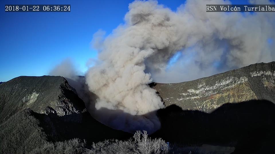 |
Figure 49. Webcam photo of an ash emission at Turrialba on 22 January 2018. Courtesy of Red Sismologica Nacional (RSN: UCR-ICE); published by the Costa Rica Star. |
Eruptive activity resumed during the middle of May, but faded toward the end of the month to weak passive emissions, and finally ended. The volcano continued with a stable permanent Strombolian activity at the bottom of the crater. During June, the volcano was stable, with strong incandescence at night reflecting the presence of minor Strombolian activity that continued through at least early July.
On 3 July a weak explosion occurred and a thin layer of ash fell on the park ranger house and the Pica seismic station (2.5 km NW). A jet-like sound was heard on 4 July from a lookout. On 16 July incandescence continued at a low level. OVSICORI reported frequent weak ash emissions from 18 July through 2 August; the ash had a very low proportion of juvenile material and a high proportion of altered material. According to a news account (The Costa Rica Star) citing the RSN, persistent tremor accompanied these emissions, and a lahar descended the Toro Amarillo River on the W flank. Weak short-lived ash emissions resumed during the last half of August, and weak to moderate incandescence could still be observed.
Seismicity and deformation. During the first week of January, weak long-period (LP) earthquakes were recorded, but no volcanic-tectonic (VT) earthquakes or tremor. In February-April, weak VT earthquakes, a few LP earthquakes, and harmonic tremor were recorded. By May, seismic activity was almost non-existent, with VT signals below the crater and sporadic tremor. The latter disappeared by the end of May.
On 16 July, seismicity increased, particularly low-frequency earthquakes, to reach about 200 events the next day, but then decreased to normal on 18 July, with sporadic short tremor. During the last week of July, seismicity again increased until an internal explosion on 27 July, after which seismicity decreased. Tremor activity increased on 4 August, and by the middle of August, about 50 LP earthquakes per day were recorded, along with spasmodic tremor of low amplitude. This heightened activity continued during the following week.
Since June 2017, the volcano tended toward deflation, but then in early 2018 became stable until the middle of February, when inflation was recorded. By June, deformation was longer measured. No significant deformation was found in July or August.
Thermal anomalies. MODIS satellite instruments processed using the MODVOLC algorithm only recorded thermal anomalies on 22 March, 2 April, and 27 April (2 pixels). The MIROVA (Middle InfraRed Observation of Volcanic Activity) system recorded one hotspot during February, numerous hotspots between mid-March and mid-May, and only several hotspots after mid-May through the end of August. All recorded MIROVA anomalies were within 2.5 km of the volcano and of low radiative power.
Sulfur dioxide measurements. Significant sulfur dioxide levels near the volcano were recorded by NASA's satellite-borne ozone instruments between 30 March and 3 June, especially between 6-15 April.
According to OVSICORI, the CO2/SO2 ratio increased to a peak of 8 during the night of 21-22 January, then remained stable until the first week of February, when it decreased. By 20 February, the ratio was stable at about 4. The ratio was low during the middle of March, but rose on 29 March. On 10 April, the SO2 flow was normal (below 1000 t/d) and remained low until the middle of May, when CO2 levels increased. High CO2/SO2 levels were measured at the end of May, but decreased in early June. On 12 and 25 June, SO2 levels were about 400 and 500 tons/day, respectively. During early July, the ratio remained low at 4, with short periods of high measurements (about 10 on 5 July). The ratio remained stable throughout the rest of July. The ratio increased on 6 August during the last phase of eruptive activity, but then decreased to normal and stable levels for the rest of the month. Near the end of August, the two gas monitoring stations were vandalized.
Information Contacts: Observatorio Vulcanologico Sismologica de Costa Rica-Universidad Nacional (OVSICORI-UNA), Apartado 86-3000, Heredia, Costa Rica (URL: http://www.ovsicori.una.ac.cr/); Red Sismologica Nacional (RSN: UCR-ICE), Universidad de Costa Rica and Instituto Costarricense de Electricidad (URL: http://rsn.ucr.ac.cr/); Washington Volcanic Ash Advisory Center (VAAC), Satellite Analysis Branch (SAB), NOAA/NESDIS OSPO, NOAA Science Center Room 401, 5200 Auth Rd, Camp Springs, MD 20746, USA (URL: www.ospo.noaa.gov/Products/atmosphere/vaac, archive at: http://www.ssd.noaa.gov/VAAC/archive.html); Hawai'i Institute of Geophysics and Planetology (HIGP) - MODVOLC Thermal Alerts System, School of Ocean and Earth Science and Technology (SOEST), Univ. of Hawai'i, 2525 Correa Road, Honolulu, HI 96822, USA (URL: http://hotspot.higp.hawaii.edu/); MIROVA (Middle InfraRed Observation of Volcanic Activity), a collaborative project between the Universities of Turin and Florence (Italy) supported by the Centre for Volcanic Risk of the Italian Civil Protection Department (URL: http://www.mirovaweb.it/); Atmospheric Chemistry and Dynamics Laboratory, NASA Goddard Space Flight Center (URL: https://sO2.gsfc.nasa.gov/); Costa Rica Star (URL: https://news.co.cr); Q Costa Rica (URL: https://qcostarica.com).
Frequent passive ash emissions continue through February 2019
This report summarizes activity at Turrialba during September 2018-February 2019. During this period there was similar activity as described earlier in 2018 (BGVN 43:09), with occasional ash explosions and numerous, sometimes continuous, periods of gas-and-ash emissions (table 8). Data were provided by the Observatorio Vulcanologico Sismologica de Costa Rica-Universidad Nacional (OVSICORI-UNA).
Table 8. Ash emissions at Turrialba, September 2018-February 2019. Cloudy weather sometimes obscured observations. Maximum plume height is above the crater rim. Information courtesy of OVSICORI-UNA.
| Date | Time | Max plume height | Plume drift | Remarks |
| 27 Aug-05 Sep 2018 | -- | 100 m | SW, W | Continuous gas-and-ash emissions. |
| 06 Sep 2018 | -- | -- | -- | Mostly gas, punctuated by small sporadic ash plumes. |
| 10 Sep 2018 | 1210 | 300 m | NW | -- |
| 01-13 Sep 2018 | -- | -- | -- | Continuous gas-and-ash emissions. |
| 17-18 Sep 2018 | -- | 300 m | SW, NW | -- |
| 27 Sep 2018 | 0915 | 200 m | NW | -- |
| 30 Sep-01 Oct 2018 | -- | 500 m | NW, NE | -- |
| 03 Oct 2018 | -- | -- | -- | Incandescence. |
| 08 Oct 2018 | 0800 | 500 m | N | -- |
| 10-16 Oct 2018 | -- | 1,000 m | Various | Intermittent emissions; some explosions, including an energetic one on 14 Oct at 1712. Clouds prevented estimate of plume height. |
| 17-23 Oct 2018 | -- | 200-500 m | E, NW, SW | Periodic gas-and-ash emissions. Frequent Strombolian events since 5 Oct. |
| 25-30 Oct 2018 | -- | -- | -- | Periodic ash emissions when weather conditions allowed observations. |
| 26 Oct 2018 | 0134 | 500 m | NE | Ashfall in neighborhoods of Coronado (San José, 35 km WSW) and San Isidro de Heredia (Heredia, 38 km W). |
| 29 Oct 2018 | 0231 | 500 m | NW | -- |
| 30 Oct 2018 | 1406 | 500 m | W | -- |
| 24 Oct-01 Nov 2018 | -- | 500 m | -- | Continuous emissions. |
| 01-06 Nov 2018 | 0530-0640 | 500 m | SW | -- |
| 02 Nov 2018 | 1523, 1703 | 500 m | -- | -- |
| 03 Nov 2018 | 0109 | 500 m | -- | Short (2-3 minutes) duration events. Ashfall reported in Coronado. |
| 05 Nov 2018 | 0620 | 600 m | NW | -- |
| 06-11 Nov 2018 | -- | 500 m | -- | Low-level, continuous gas-and-ash emissions occasionally punctuated by energetic explosions that sent plumes as high as 500 m and caused ashfall in several areas downwind, including Cascajal de Coronado, Desamparados (35 km WSW), San Antonio, Guadalupe (32 km WSW), Sabanilla, San Pedro Montes de Oca, Moravia (31 km WSW), Heredia, and Coronado (San José, 35 km WSW). Weather prevented observations on 12 Nov. |
| 13-19 Nov 2018 | -- | -- | -- | Periodic, passive ash emissions visible in webcam images or during cloudy conditions inferred from the seismic data. |
| 22 Nov 2018 | 0710 | 100 m | W | -- |
| 23 Nov 2018 | -- | -- | -- | Frequent pulses of ash. |
| 23-25 Nov 2018 | -- | 500 m | -- | Occasional Strombolian explosions ejected lava bombs deposited near the crater; residents of Cascajal de Coronado reported hearing several booming sounds. |
| 26-27 Nov 2018 | -- | -- | -- | Passive emissions with small quantities of ash visible. Minor ashfall in San Jose (Cascajal de Coronado and Dulce Nombre), San Pedro Montes de Oca, and neighborhoods of Heredia. |
| 28 Nov-03 Dec 2018 | -- | 500 m | N, NW, SW | Ashfall in Santo Domingo (36 km WSW) on 2 Dec. |
| 05 Dec 2018 | -- | -- | -- | Minor emission. |
| 06 Dec 2018 | -- | -- | S | Emission. |
| 08 Dec 2018 | 0749 | 500 m | NW | -- |
| 09 Dec 2018 | -- | 1,000 m | -- | Ashfall in areas of Valle Central. |
| 10 Dec 2018 | -- | -- | -- | Emissions periodically observed during periods of clear viewing. Ashfall in Moravia (31 km WSW) and Santa Ana, and residents of Heredia noted a sulfur odor. |
| 11-12 Dec 2018 | -- | 500 m | NW, SW | The Tico Times stated some flights were delayed at San Jose airport, 67 km away. |
| 13 Dec 2018 | -- | -- | -- | Pulsing ash emissions; ashfall in Guadalupe (32 km WSW) and Valle Central. |
| 14-16 Dec 2018 | -- | -- | W, SW | Emissions with diffuse amounts of ash. |
| 05-06 Jan 2019 | 0815 | -- | -- | Increased after midnight on 6 Jan. |
| 28 Jan-04 Feb 2019 | -- | -- | -- | Minor, sporadic ash emissions rose to low heights during most days. |
| 01 Feb 2019 | 0640 | 1,500 m | NW | -- |
| 08 Feb 2019 | 0540 | 200 m | -- | Sporadic ash emissions for more than one hour. |
| 11 Feb 2019 | -- | -- | -- | Very small ash emission. |
| 13-15 Feb 2019 | 200-300 m | NW, W, SW | Almost continuous gas emissions with minor ash content. | |
| 15 Feb 2019 | 1330 | 1,000 m | W | -- |
| 18 Feb 2019 | 1310 | 500 m | W | -- |
| 21 Feb 2019 | -- | 300 m | NW | Frequent ash pulses. |
| 22-24 Feb 2019 | -- | 300 m | NW, SW | Frequent ash emissions of variable intensity and duration. On 22 Feb ash fell in Santa Cruz (31 km WSW) and Santa Ana, and a sulfur odor was evident in Moravia. |
| 28 Feb 2019 | 1050 | 500 m | SW | Ash pulses. |
According to OVSICORI-UNA's annual summary for 2018, a slow decline in activity occurred after the volcano reached its highest emission rate during 2016. Activity during 2018 was consistent with an open system, generating frequent passive ash emissions. The volcano emitted ash on 58% of the days during the year. Some explosions were large enough to eject ballistics more than 400 m around the crater. Typical activity can be seen in a photo from 11 September 2018 (figure 50) and satellite imagery on 7 November 2018 (figure 51).
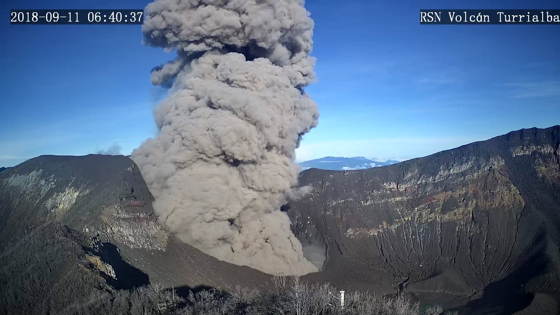 |
Figure 50. Photo of an ash explosion at Turrialba taken on 11 September 2018. Courtesy of Red Sismologica Nacional (RSN: UCR-ICE), Universidad de Costa Rica. |
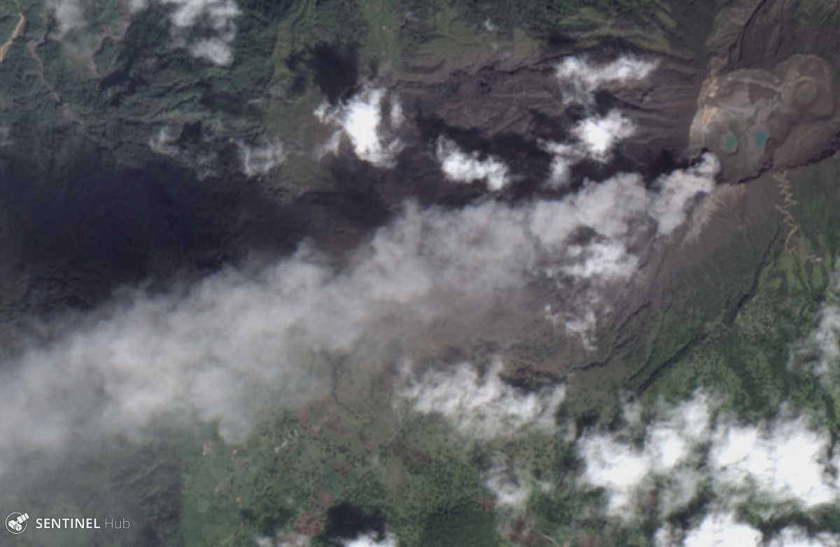 |
Figure 51. Sentinel-2 satellite image of an ash emission from Turrialba on 7 November 2018, taken in natural color (gamma adjusted). Courtesy of Sentinel Hub Playground. |
During January into early February 2019, passive ash emissions continued irregularly and with less intensity and duration. Emissions sometimes lacked ash. In their report of 4 February 2019, OVSICORI-UNA indicated that passive ash emissions were weak and slow. For the rest of February, they characterized ash emissions as frequent, but of low intensity.
Seismic activity. On 1 November 2018 OVSICORI-UNA reported that seismicity remained high, and involved low-amplitude banded volcanic tremor along with long-period (LP) and volcano-tectonic (VT) earthquakes. In late January-early February 2019, OVSICORI-UNA reported that seismicity remained relatively stable, although a small increase was associated with the hydrothermal system. VT earthquakes were absent, and tremors had decreased in both energy and duration. The number of low-frequency LP volcanic earthquakes remained stable, although they had decreasing amplitudes. No explosions were documented, and emissions were weak and had short durations and very dilute ash content.
Thermal anomalies. No thermal anomalies were recorded during the reporting period using MODIS satellite instruments processed by MODVOLC algorithm. The MIROVA (Middle InfraRed Observation of Volcanic Activity) system detected five scattered hotspots during September-October 2018, none during November-December 2018, and two during January-February 2019. All were within 2 km of the volcano and of low radiative power.
Gas measurements. Significant sulfur dioxide levels near the volcano were recorded by NASA's satellite-borne ozone instruments only on 29 September 2018 (both NPP/OMPS and Aura/OMI instruments) and on 11 February 2019 (Sentinel 5P/TROPOMI instrument). OVSICORI-UNA's gas measuring instruments were compromised in September 2018 through January 2019 due to vandalism. In early February, however, they detected hydrogen sulfide for the first time since 2016.
Information Contacts: Observatorio Vulcanologico Sismologica de Costa Rica-Universidad Nacional (OVSICORI-UNA), Apartado 86-3000, Heredia, Costa Rica (URL: http://www.ovsicori.una.ac.cr/); Red Sismologica Nacional (RSN) a collaboration between a) the Sección de Sismología, Vulcanología y Exploración Geofísica de la Escuela Centroamericana de Geología de la Universidad de Costa Rica (UCR), and b) the Área de Amenazas y Auscultación Sismológica y Volcánica del Instituto Costarricense de Electricidad (ICE), Costa Rica (URL: https://rsn.ucr.ac.cr/); Sentinel Hub Playground (URL: https://www.sentinel-hub.com/explore/sentinel-playground); Hawai'i Institute of Geophysics and Planetology (HIGP) - MODVOLC Thermal Alerts System, School of Ocean and Earth Science and Technology (SOEST), Univ. of Hawai'i, 2525 Correa Road, Honolulu, HI 96822, USA (URL: http://hotspot.higp.hawaii.edu/); MIROVA (Middle InfraRed Observation of Volcanic Activity), a collaborative project between the Universities of Turin and Florence (Italy) supported by the Centre for Volcanic Risk of the Italian Civil Protection Department (URL: http://www.mirovaweb.it/); Global Sulfur Dioxide Monitoring Page, Atmospheric Chemistry and Dynamics Laboratory, NASA Goddard Space Flight Center (NASA/GSFC), 8800 Greenbelt Road, Goddard, Maryland, USA (URL: https://so2.gsfc.nasa.gov/); Costa Rica Star (URL: https://news.co.cr); The Tico Times (URL: https://ticotimes.net).
Activity diminishes during March-October 2019, but small ash emissions continue
This report summarizes activity at Turrialba during March-October 2019. Typical activity similar to that reported in late 2018 and early 2019 (BGVN 44:04) included periodic weak ash explosions and numerous emissions containing some ash. However, during this period activity appeared to diminish with time. Data were provided by weekly reports by the Observatorio Vulcanologico Sismologica de Costa Rica-Universidad Nacional (OVSICORI-UNA).
According to OVSICORI-UNA, only highly diluted ash emissions were recorded from 22 April to 27 May (note that no reports were available online from the last week of March until 22 April). Weak ash explosions were again noted on 28 July, 4 August, and possibly on 20 October. OVSICORI-UNA reported more explosions or emissions containing ash on 25 and 28 October (table 9).
Table 9. Summary of reported activity at Turrialba, March-October 2019. Cloudy weather sometimes obscured observations. Maximum plume height is above the crater rim. Information courtesy of OVSICORI-UNA.
| Date | Time | Max plume height | Plume drift | Remarks |
| 01 Mar 2019 | 0444 | 200 m | NE | -- |
| 02-04 Mar 2019 | -- | 200-300 m | -- | Continuous emissions with minor amounts of ash. |
| 09-12 Mar 2019 | -- | 1,000 m | -- | Gas plumes containing minor amounts of ash. |
| 16-17 Mar 2019 | -- | -- | -- | Frequent and discontinuous emissions, but no visual confirmation due to poor visibility. |
| 20-22 Mar 2019 | -- | 300 m | W, SW | Continuous emissions of steam with periodic pulses of diffuse ash; sulfur odor noted in Tierra Blanca de Cartago on 22 March. |
| 23-26 Mar 2019 | -- | -- | -- | Steam plumes with low concentration of magmatic gases. |
| 24 Mar 2019 | 0503 | 500 m | -- | Series of four pulses with ash. |
| 31 Mar 2019 | 0735 | -- | -- | Explosion followed by passive emissions with low concentration of magmatic gases. Seismicity dominated by low-frequency events. |
| 08 Apr 2019 | -- | -- | -- | Minor ash emissions. |
| 24 Apr 2019 | -- | -- | -- | Diffuse ash emission. |
| 26 Apr 2019 | -- | -- | N | Emission with low ash content. |
| 27 Apr 2019 | 0722 | below 100 m | -- | Weak, brief explosion with ash plume. |
| 04 May 2019 | 0524 | -- | -- | Emission of very diluted ash. |
| 12-19 May 2019 | -- | -- | -- | Passive, short-duration emissions with small amounts of ash occurred sporadically. |
| 19-20 May 2019 | -- | -- | -- | Prolonged and intermittent periods of emissions with minor amounts of ash. |
| 28 Jul 2019 | 1441 | -- | -- | Weak explosion and ash emission after 30 minutes of heavy rain. Inclement weather prevented visual confirmation. Ashfall in La Picada (N) and El Retiro farms. |
| 03-04 Aug 2019 | -- | -- | -- | Two small explosions, with some ash in the second. |
| 11 Aug 2019 | -- | -- | -- | Weak emission during night, identified by its seismic signal. No ash emission observed. |
| 05 Aug-19 Oct 2019 | -- | -- | -- | No ash detected. |
| 20 Oct 2019 | 2100 | -- | -- | Explosion identified with seismicity; weather conditions prevented visual observation. No ashfall reported. |
| 25 Oct 2019 | 0400, 0700 | -- | -- | Weak explosion at 0400, with ash. Ash at 0700 not associated with seismic signal, so could be a small intra-crater collapse. |
| 28 Oct 2019 | 1500 | -- | -- | Weak emission containing ash. |
A report from Red Sismologica Nacional (RSN) about the 28 October ash explosion noted that it occurred at 1501 local time and lasted about 5 minutes. There were no reports of ashfall, but the crater webcam captured the small plume rising from the active vent. Incandescence in the active crater continued to be seen on the monitoring cameras.
Information Contacts: Observatorio Vulcanologico Sismologica de Costa Rica-Universidad Nacional (OVSICORI-UNA), Apartado 86-3000, Heredia, Costa Rica (URL: http://www.ovsicori.una.ac.cr/); Red Sismologica Nacional (RSN) a collaboration between a) the Sección de Sismología, Vulcanología y Exploración Geofísica de la Escuela Centroamericana de Geología de la Universidad de Costa Rica (UCR), and b) the Área de Amenazas y Auscultación Sismológica y Volcánica del Instituto Costarricense de Electricidad (ICE), Costa Rica (URL: https://rsn.ucr.ac.cr/).
New eruptive period on 18 June 2020 consisted of ash eruptions
Turrialba is a stratovolcano located in Costa Rica that overlooks the city of Cartago. Three well-defined craters occur at the upper SW end of a broad 800 x 2,200 m summit depression that is breached to the NE. Activity described in the previous report primarily included weak ash explosions and minor ash emissions (BGVN 44:11). This reporting period updates information from November 2019-August 2020; volcanism dominantly consists of ash emissions during June-August, based on information from daily and weekly reports by the Observatorio Vulcanologico Sismologica de Costa Rica-Universidad Nacional (OVSICORI-UNA) and satellite data.
Volcanism during November 2019 through mid-June was relatively low, dominated by low SO2 emissions (100-300 tons/day) and typical low seismic tremors. A single explosion was recorded at 1850 on 7 December 2019, and two gas-and-steam plumes rose 800 m and 300 m above the crater on 25 and 27 December, respectively. An explosion was detected on 29 January 2020 but did not result in any ejecta. An overflight during the week of 10 February measured the depth of the crater (140 m); since the previous measurements made in February 2019 (220 m), the crater has filled with 80 m of debris due to frequent collapses of the NW and SE internal crater walls. Beginning around February and into at least early May 2020 the Sentinel-2 MODIS Thermal Volcanic Activity graph provided by the MIROVA system detected a small cluster of thermal anomalies (figure 52). Some of these anomalies were faintly registered in Sentinel-2 thermal satellite imagery during 10 and 25 April, with a more distinct anomaly occurring on 15 May (figure 53).
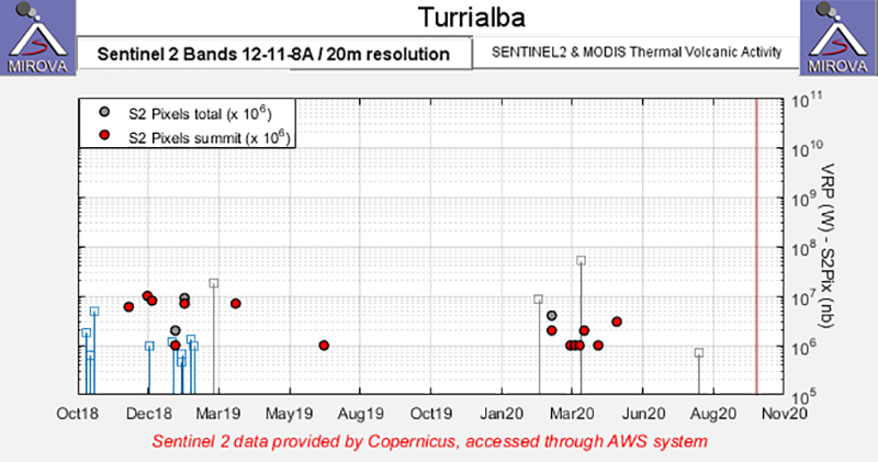 |
Figure 52. A small cluster of thermal anomalies were detected in the summit area of Turrialba (red dots) during February-May 2020 as recorded by the Sentinel-2 MODIS Thermal Volcanic Activity data (bands 12, 11, 8A). Courtesy of MIROVA. |
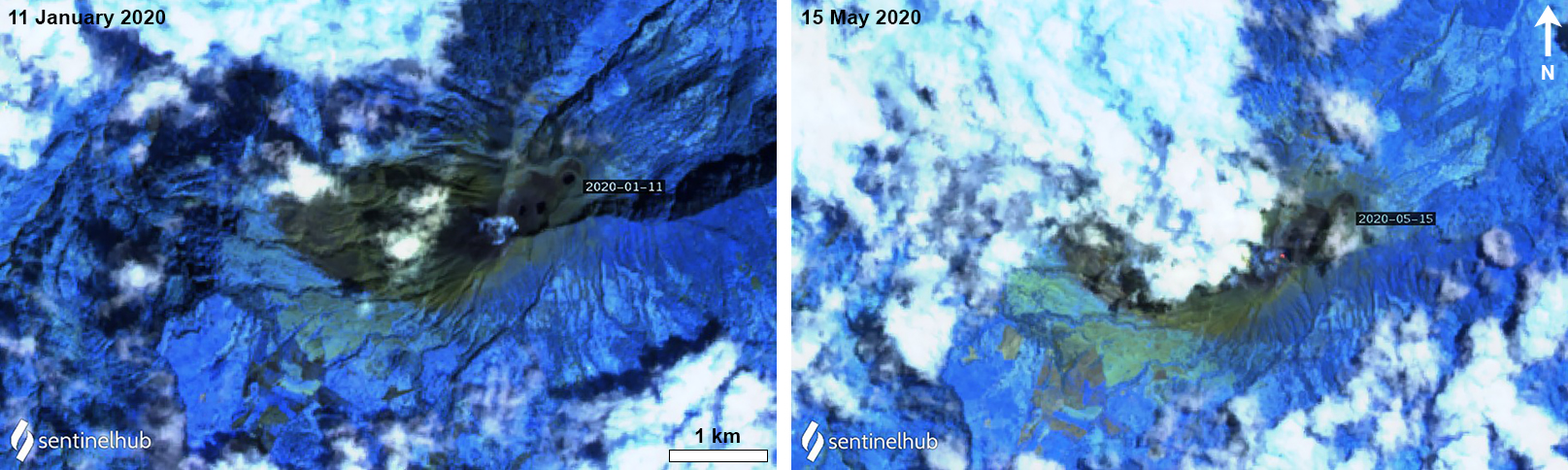 |
Figure 53. Sentinel-2 thermal satellite imagery detected minor gas-and-steam emissions (left) and a weak thermal anomaly (right) in the summit crater at Turrialba on 11 January and 15 May 2020, respectively. Sentinel-2 atmospheric penetration (bands 12, 11, 8A) images courtesy of Sentinel Hub Playground. |
On 18 June activity increased, which marked the start of a new eruptive period that produced ash emissions rising 100 m above the crater rim at 1714, 1723, and 1818. The next morning, 19 June, two more events at 1023 and 1039 resulted in ash emissions rising 100 m above the crater. During 23-26 June small ash emissions continued to occur each day, rising no higher than 100 m above the crater. A series of small ash eruptions that rose 100 m above the crater occurred during 28 and 29 June; four events were recorded at 0821, 1348, 1739, and 2303 on 28 June and five more were recorded at 0107, 0232, 0306, 0412, and 0818 on 29 June. The two events at 0107 and 0412 were accompanied by ballistics ejected onto the N wall of the crater, according to OVSICORI-UNA.
Almost daily ash emissions continued during 1-7 July, rising less than 100 m above the crater; no ash emissions were observed on 3 July. On 6 July, gas-and-steam and ash emissions rose hundreds of meters above the crater at 0900, resulting in local ashfall. Passive gas-and-steam emissions with minor amounts of ash were occasionally visible during 9-10 July. On 14 July an eruptive pulse was observed, generating brief incandescence at 2328, which was likely associated with a small ash emission. Dilute ash emissions at 1028 on 16 July preceded an eruption at 1209 that resulted in an ash plume rising 200 m above the crater. Ash emissions of variable densities continued through 20 July rising as high as 200 m above the crater; on 20 July incandescence was observed on the W wall of the crater. An eruptive event at 0946 on 29 July produced an ash plume that rose 200-300 m above the crater rim. During 30-31 July a series of at least ten ash eruptions were detected, rising no higher than 200 m above the crater, each lasting less than ten minutes. Some incandescence was visible on the SW wall of the crater during this time.
On 1 August at 0746 an ash plume rose 500 m above the crater. During 4-5 August a total of 19 minor ash emissions occurred, accompanied by ash plumes that rose no higher than 200 m above the crater. OVSICORI-UNA reported on 21 August that the SW wall of the crater had fractured; some incandescence in the fracture zone had been observed the previous month. Two final eruptions were detected on 22 and 24 August at 1253 and 2023, respectively. The eruption on 24 August resulted in an ash plume that rose to a maximum height of 1 km above the crater.
Information Contacts: Observatorio Vulcanologico Sismologica de Costa Rica-Universidad Nacional (OVSICORI-UNA), Apartado 86-3000, Heredia, Costa Rica (URL: http://www.ovsicori.una.ac.cr/, https://www.facebook.com/OVSICORI/); MIROVA (Middle InfraRed Observation of Volcanic Activity), a collaborative project between the Universities of Turin and Florence (Italy) supported by the Centre for Volcanic Risk of the Italian Civil Protection Department (URL: http://www.mirovaweb.it/); Sentinel Hub Playground (URL: https://www.sentinel-hub.com/explore/sentinel-playground).
Small phreatic explosions in June and July 2021
Volcanism at Turrialba increased after September 2014 with cycles of ash explosions, numerous weak and passive ash plumes, and emissions that continued into 2019; thereafter activity progressively diminished until weak explosions and ash emissions took place between mid-June and 24 August 2020 (BGVN 43:09, 44:04, 44:11, 45:09). The following report summarizes activity from September 2020 through August 2021 and is based primarily on information from weekly reports published by the Observatorio Vulcanologico Sismologica de Costa Rica-Universidad Nacional (OVSICORI-UNA) and satellite data.
Based on OVSICORI-UNA’s annual report, cooling allowed the reappearance of a hydrothermal system, as indicated by the presence of H2S in the gas plume. Landslides along the rim filled in the crater by 50 m, raising the floor from 180 m depth in 2017 to only 130 m deep by the end of 2020. The crater’s diameter also increased, particularly in the S. Seismicity during this period was generally low, with some fluctuations attributed to changes in the hydrothermal system due to infiltration by rainwater. White emissions were observed throughout the reporting period in Sentinel-2 satellite images and OVSICORI-UNA webcam images (figure 54).
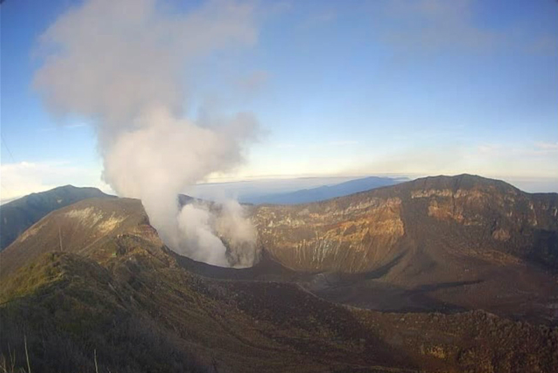 |
Figure 54. Webcam image of a typical white degassing plume with no ash at Turrialba, seen here on 23 March 2021. Courtesy of OVSICORI-UNA. |
OVSICORI-UNA reported a weak 2-minute phreatic explosion at 1800 on 13 June that ejected a small amount of non-juvenile ash to 300 m above the crater and drifted SW. Trace ashfall (less than 1 mm accumulation) was reported in Monte Calas (2 km SSE) and in La Central (2 km SW). Strong gas odors were reported in La Pastora (6 km SSW) in the early morning, and rumbles were heard from various places around the volcano. The explosion was not associated with changes in seismicity, deformation, or gas chemistry, but may have been related to rainfall. Observation with infrared cameras showed a decrease in area of the fumarolic zone within the active crater between November 2020 and 16 June 2021, as well as the presence of some very active fumaroles. Fieldwork by OVSICORI-UNA in mid-March found a fumarole temperature at 440°C on the inner NW wall of the active crater.
According to OVSICORI-UNA, a one-minute explosion was recorded at 1130 on 23 July 2021, though weather clouds prevented visual confirmation of a plume; ash fell in areas 3.5 km W. Heavy rainfall in the area on 22 July had caused major flooding in a nearby town of Turrialba (SW of the volcano) and may have triggered the explosion. By 24 July lakes had formed in and near the central crater (figure 55). Seismicity did not change, and geodesic measurements confirmed that slight contraction continued.
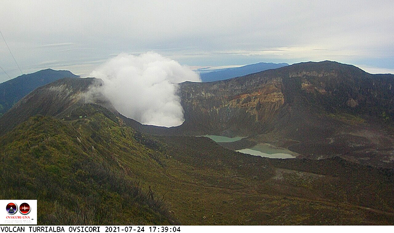 |
Figure 55. Image of Turrialba on 24 July 2021 showing that a lake(s) has formed in the central crater and between craters as a result of heavy rainfall. Courtesy of OVSICORI-UNA. |
Meteorological clouds usually obscured Sentinel-2 satellite observations. However, there was a weak but persistent thermal signal throughout September 2020-August 2021, along with the weak white emissions. TROPOMI data from the Sentinel-5P satellite did not show significant SO2 levels near the Irazú-Turrialba massif during September 2020-January 2021. However, some SO2 emissions were recorded thereafter, most prominently on 15 March, 23 March (figure 56), and 24 April 2021. None were recorded during the 13 June or 23 July explosions.
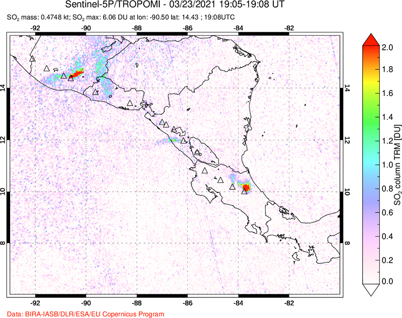 |
Figure 56. Sulfur dioxide emission drifting N from the Irazú-Turrialba massif on 23 March 2021 (lower right), as recorded by the TROPOMI instrument aboard the Sentinel-5P satellite. Courtesy of NASA Global Sulfur Dioxide Monitoring Page. |
Information Contacts: Observatorio Vulcanologico Sismologica de Costa Rica-Universidad Nacional (OVSICORI-UNA), Apartado 86-3000, Heredia, Costa Rica (URL: http://www.ovsicori.una.ac.cr/, https://www.facebook.com/OVSICORI/); Sentinel Hub Playground (URL: https://www.sentinel-hub.com/explore/sentinel-playground); NASA Global Sulfur Dioxide Monitoring Page, Atmospheric Chemistry and Dynamics Laboratory, NASA Goddard Space Flight Center (NASA/GSFC), 8800 Greenbelt Road, Goddard MD, USA (URL: https://so2.gsfc.nasa.gov/).
Occasional weak phreatic explosions during November 2021-February 2022
Turrialba, in Costa Rica, is a large stratovolcano that covers an area of 500 km2. Three well-defined craters occur at the upper SW end of a broad 800 x 2,200 m summit depression that is breached to the NE. Five major explosive eruptions have occurred during the past 3,500 years. A series of explosive eruptions during the 19th century were sometimes accompanied by pyroclastic flows. Minor eruptive activity has been frequent since 2010. The following report summarizes activity from September 2021-February 2022 and is based primarily on information from periodic reports published by the Observatorio Vulcanologico Sismologica de Costa Rica-Universidad Nacional (OVSICORI-UNA) and satellite data. During this period, activity continued at a low level, similar to that observed since the beginning of September 2020 (BGVN 46:09), with occasional weak ash explosions and ash emissions.
Based on OVSICORI-UNA’s 2021 annual report, activity continued to decrease in 2021, a trend that began in 2019. Frequent rim collapses into the bottom of the crater were evident. Sporadic ash emissions occurred between 13 June and 23 July 2021 (BGVN 46:09), and again beginning on 3 November continuing into late February 2022. Neither the seismic nor geodetic data suggested a new supply of magma, and petrological observations from ash samples revealed a large amount of lithic material and less than 12% of fresh magmatic material. These observations strongly suggested to OVSICORI-UNA that the explosions were phreatic (caused by the interaction between rainwater and a hot body or shallow magma).
A one-minute explosion from the West Crater at 0646 on 3 November produced a plume that rose 200 m above the crater rim and drifted W. Ash from the plume contained very few fragments of juvenile glassy material (less than 5%), and abundant porous and lithic material (~85%), indicating to OVSICORI-UNA that the explosion was mainly phreatic. Another small explosion was recorded on 7 November. On 11 November, a small area of incandescence was visible on the internal SW wall of the summit vent, which was vigorously degassing. An explosion at 0624 on 23 November lasted less than a minute and produced a plume that rose less than 500 m above the crater rim that drifted SW.
Incandescence on the NW inner wall of the West Crater, which had been periodically visible since mid-November, was visible during 26-27 December, suggesting that fumarolic temperatures exceeded 300°C. OVSICORI-UNA reported three weak ash explosions on 28 December. The first, at 0644, was one minute long and produced an ash emission that rose 50 m above the crater rim and drifted W. Another, recorded at 1105 by the seismic and infrasound networks, was also heard by authorities in the Parque Nacional Volcán Turrialba. No data were reported for the third explosion.
An OVSICORI-UNA report on 14 January 2022 indicated that atmospheric SO2 levels measured by the TROPOMI Sentinel-5P satellite showed an almost daily detection from the volcanic plume. However, detected values were relatively low (less than 50 tons) except for a few days, particularly on 29 December 2021 (~126 tons) and 7 January 2022 (84 tons).
Incandescence from the West Crater was visible overnight during 15-16 January 2022. Four explosions were recorded on 17 January, including one at 2126 and another at 2131. The second explosion was the strongest since June 2021 and generated an ash-rich plume that rose about 1 km above the summit and was accompanied by a pyroclastic flow that extended more than 400 m. Ashfall and a sulfur odor were reported by residents in Coronado, Tres Rios (30 km SW), Alajuela (50 km W), and Santa Ana (46 km WSW). The ash contained less than 3% juvenile material, indicating that the explosion was phreatic. Another explosion at 1115 on 18 January generated a plume that rose 300 m and drifted SW.
During 19-24 January, periodic explosions lasting 1-2 minutes each were recorded at the West Crater. At 0546 on 19 January an explosion produced an ash plume that rose 200 m above the summit and drifted W. In addition, a small explosion at 1052 generated a plume that rose 50 m and drifted NW. At 0706 on 24 January, an explosion generated a plume that rose 100 m and drifted SW. Two points of incandescence on the internal SW crater wall were also visible. Three areas of incandescence in the West Crater were visible during 26-27 January. A weak explosion was recorded on 30 January.
According to OVSICORI-UNA, on 6 February at 1259, a weak phreatic explosion at West Crater produced an ash plume that rose 100 m above the crater rim. Two incandescent points in the crater were visible in overnight webcam images during 7-8 February. Another explosion at the West Crater on 19 February at 0412 produced a small ash plume that rose 100 m above the summit and drifted W. Minor ashfall was reported by park rangers in Parque Nacional Volcán Irazú. A weaker explosion was recorded later that day at 1624, though weather clouds prevented visual confirmation.
A point of incandescence on the SW wall of the West Crater was visible on 23 February, coincident with the area of strongest gas emissions. An explosion at 1955 on 27 February produced a diffuse ash plume that rose 300 m above the summit and drifted NE. Rumbling sounds heard on 28 February were sometimes coincident with minor ash emissions.
Information Contacts: Observatorio Vulcanologico Sismologica de Costa Rica-Universidad Nacional (OVSICORI-UNA), Apartado 86-3000, Heredia, Costa Rica (URL: http://www.ovsicori.una.ac.cr).
Small phreatic eruption on 17 July 2022
Activity began to subside at Turrialba after 2019, following a period of weak ash explosions and emissions, allowing for the reappearance of a hydrothermal system. Thereafter, occasional weak explosions at this Costa Rican stratovolcano were thought to be phreatic (steam-driven), with associated minor passive ash emissions (BGVN 46:09, 47:04). The following report summarizes activity from March-August 2022 and is based primarily on information from periodic reports published by the Observatorio Vulcanologico Sismologica de Costa Rica-Universidad Nacional (OVSICORI-UNA) and satellite data.
Overall activity was at a low level during this reporting period. Occasional small rumblings were recorded, some associated with minor ash emissions. Seismicity remained low, eventually returning to the pre-June 2021 level, and geodetic monitoring showed that the Irazú-Turrialba massif continued to subside and contract, especially around the active Turrialba crater.
In early April 2022 an inspection of the bottom of the West Crater (or Bat Crater) with a drone revealed some fumaroles, mainly in the eastern sector, releasing steam and sulfur gases. The fumaroles registered temperatures of at least 113°C according to remote measurement with an infrared thermograph.
According to OVSICORI-UNA, at 0749 on 17 July a brief phreatic eruption was recorded. An ash emission rose less than 500 m above the crater and drifted SW, with minor ashfall in Irazú Volcano National Park. This was the only eruption during the reporting period, and the first since 27 February 2022. Seismic activity continued to decrease.
A sulfur dioxide plume was detected originating from Turrialba on 30 August, using the TROPOMI instrument on the Sentinel-5P satellite. According to OVSICORI-UNA, the plume contained 108 tons of SO2.
Information Contacts: Observatorio Vulcanologico Sismologica de Costa Rica-Universidad Nacional (OVSICORI-UNA), Apartado 86-3000, Heredia, Costa Rica (URL: http://www.ovsicori.una.ac.cr/); NASA Global Sulfur Dioxide Monitoring Page, Atmospheric Chemistry and Dynamics Laboratory, NASA Goddard Space Flight Center (NASA/GSFC), 8800 Greenbelt Road, Goddard MD, USA (URL: https://so2.gsfc.nasa.gov/).
This compilation of synonyms and subsidiary features may not be comprehensive. Features are organized into four major categories: Cones, Craters, Domes, and Thermal Features. Synonyms of features appear indented below the primary name. In some cases additional feature type, elevation, or location details are provided.
Cones |
||||
| Feature Name | Feature Type | Elevation | Latitude | Longitude |
| Armado, El | Cone | 2750 m | ||
| Dos Novillos, Volcán | Stratovolcano | 2530 m | ||
| Finca Liebres, Volcán | Stratovolcano | 3074 m | ||
| Tiendilla | Cone | 2791 m | ||
|
|
||||||||||||||||||||||||
There is data available for 21 confirmed Holocene eruptive periods.
2022 Jul 17 - 2022 Jul 17 Confirmed Eruption Max VEI: 1
| Episode 1 | Eruption Episode | |||||||||||||||
|---|---|---|---|---|---|---|---|---|---|---|---|---|---|---|---|
| 2022 Jul 17 - 2022 Jul 17 | Evidence from Observations: Reported | ||||||||||||||
|
List of 1 Events for Episode 1
| |||||||||||||||
2021 Nov 3 - 2022 Feb 28 Confirmed Eruption Max VEI: 1
| Episode 1 | Eruption Episode | ||||||||||||||||||||
|---|---|---|---|---|---|---|---|---|---|---|---|---|---|---|---|---|---|---|---|---|
| 2021 Nov 3 - 2022 Feb 28 | Evidence from Observations: Reported | |||||||||||||||||||
|
List of 2 Events for Episode 1
| ||||||||||||||||||||
2021 Jun 13 - 2021 Jul 23 Confirmed Eruption Max VEI: 1
| Episode 1 | Eruption Episode | ||||||||||||||||||||||||||||||
|---|---|---|---|---|---|---|---|---|---|---|---|---|---|---|---|---|---|---|---|---|---|---|---|---|---|---|---|---|---|---|
| 2021 Jun 13 - 2021 Jul 23 | Evidence from Observations: Reported | |||||||||||||||||||||||||||||
|
List of 4 Events for Episode 1
| ||||||||||||||||||||||||||||||
2020 Jun 18 - 2020 Aug 24 Confirmed Eruption Max VEI: 1
| Episode 1 | Eruption Episode | |||||||||||||||
|---|---|---|---|---|---|---|---|---|---|---|---|---|---|---|---|
| 2020 Jun 18 - 2020 Aug 24 | Evidence from Observations: Reported | ||||||||||||||
|
List of 1 Events for Episode 1
| |||||||||||||||
2015 Mar 8 - 2019 Dec 7 Confirmed Eruption Max VEI: 3
| Episode 1 | Eruption Episode | Cráter Central, Cráter Oeste | |||||||||||||||||||||||||||||||||||||||||||||||||||||||||||||||||||||||||||||||||||||||||||||||||||||||||||||||||||||||||||||||||||||||||||||||||||||||||||||||||||||||||||||||||||||||||||||||||||||||||||||||||||||||||||
|---|---|---|---|---|---|---|---|---|---|---|---|---|---|---|---|---|---|---|---|---|---|---|---|---|---|---|---|---|---|---|---|---|---|---|---|---|---|---|---|---|---|---|---|---|---|---|---|---|---|---|---|---|---|---|---|---|---|---|---|---|---|---|---|---|---|---|---|---|---|---|---|---|---|---|---|---|---|---|---|---|---|---|---|---|---|---|---|---|---|---|---|---|---|---|---|---|---|---|---|---|---|---|---|---|---|---|---|---|---|---|---|---|---|---|---|---|---|---|---|---|---|---|---|---|---|---|---|---|---|---|---|---|---|---|---|---|---|---|---|---|---|---|---|---|---|---|---|---|---|---|---|---|---|---|---|---|---|---|---|---|---|---|---|---|---|---|---|---|---|---|---|---|---|---|---|---|---|---|---|---|---|---|---|---|---|---|---|---|---|---|---|---|---|---|---|---|---|---|---|---|---|---|---|---|---|---|---|---|---|---|---|---|---|---|---|---|---|---|---|---|
| 2015 Mar 8 - 2015 Aug 15 | Evidence from Observations: Reported | |||||||||||||||||||||||||||||||||||||||||||||||||||||||||||||||||||||||||||||||||||||||||||||||||||||||||||||||||||||||||||||||||||||||||||||||||||||||||||||||||||||||||||||||||||||||||||||||||||||||||||||||||||||||||||
|
List of 42 Events for Episode 1 at Cráter Central, Cráter Oeste
| ||||||||||||||||||||||||||||||||||||||||||||||||||||||||||||||||||||||||||||||||||||||||||||||||||||||||||||||||||||||||||||||||||||||||||||||||||||||||||||||||||||||||||||||||||||||||||||||||||||||||||||||||||||||||||||
| Episode 2 | Eruption Episode | Cráter Central, Cráter Oeste | |||||||||||||||||||||||||||||||||||||||||||||||||||||||||||||||||||||||||||||||||||||||||||||||||||
|---|---|---|---|---|---|---|---|---|---|---|---|---|---|---|---|---|---|---|---|---|---|---|---|---|---|---|---|---|---|---|---|---|---|---|---|---|---|---|---|---|---|---|---|---|---|---|---|---|---|---|---|---|---|---|---|---|---|---|---|---|---|---|---|---|---|---|---|---|---|---|---|---|---|---|---|---|---|---|---|---|---|---|---|---|---|---|---|---|---|---|---|---|---|---|---|---|---|---|---|---|
| 2015 Oct 16 - 2015 Nov 30 | Evidence from Observations: Reported | |||||||||||||||||||||||||||||||||||||||||||||||||||||||||||||||||||||||||||||||||||||||||||||||||||
|
List of 18 Events for Episode 2 at Cráter Central, Cráter Oeste
| ||||||||||||||||||||||||||||||||||||||||||||||||||||||||||||||||||||||||||||||||||||||||||||||||||||
| Episode 3 | Eruption Episode | Cráter Central, Cráter Oeste | ||||||||||||||||||||||||||||||||||||||||||||||||||||||||||||||||||||||||||||||||||||||||||||||||||||||||||||||||||||||||||||||||||||||||||||||||||||||||||||||||||||||||||||||||||||||||||||||||||||||||||||||||||||||||||||||||||||||||||||||||||||||||||||||||||||||||||||||||||||||||||||||||||||||||||||||||||||||||||||||||||||||||||||||||||||||||||||||||||||||||||||||||||||||||||||||||||||||||||||||||||||||||||||||||||||||||||||||||||||||||||||||||||||||||||||||||||||||||||||||||||||||||||||||||||||||||||||||||||||||||||||||||||||||||||||||||||||||||||||||||||||||||||||||||||||||||||||||||||||||||||||||||||||||||||||||||||||||||||||||||||||||||||||||||||||||||||||||||||||||||||||||||||||||||||||||||||||||||||||||||||||||||||||||||||||||||||||||||||||||||||||||||||||||||||||||||||||||||||||||||||||||||||||||||||||||||||||||||||||||||||||||||||||||||||||||||||||||||||||||||||||||||||||||||||||||||||||||||||||||||||||||||||||||||||||||||||||||||||||||||||||||||||||||||||||||||||||||||||||||
|---|---|---|---|---|---|---|---|---|---|---|---|---|---|---|---|---|---|---|---|---|---|---|---|---|---|---|---|---|---|---|---|---|---|---|---|---|---|---|---|---|---|---|---|---|---|---|---|---|---|---|---|---|---|---|---|---|---|---|---|---|---|---|---|---|---|---|---|---|---|---|---|---|---|---|---|---|---|---|---|---|---|---|---|---|---|---|---|---|---|---|---|---|---|---|---|---|---|---|---|---|---|---|---|---|---|---|---|---|---|---|---|---|---|---|---|---|---|---|---|---|---|---|---|---|---|---|---|---|---|---|---|---|---|---|---|---|---|---|---|---|---|---|---|---|---|---|---|---|---|---|---|---|---|---|---|---|---|---|---|---|---|---|---|---|---|---|---|---|---|---|---|---|---|---|---|---|---|---|---|---|---|---|---|---|---|---|---|---|---|---|---|---|---|---|---|---|---|---|---|---|---|---|---|---|---|---|---|---|---|---|---|---|---|---|---|---|---|---|---|---|---|---|---|---|---|---|---|---|---|---|---|---|---|---|---|---|---|---|---|---|---|---|---|---|---|---|---|---|---|---|---|---|---|---|---|---|---|---|---|---|---|---|---|---|---|---|---|---|---|---|---|---|---|---|---|---|---|---|---|---|---|---|---|---|---|---|---|---|---|---|---|---|---|---|---|---|---|---|---|---|---|---|---|---|---|---|---|---|---|---|---|---|---|---|---|---|---|---|---|---|---|---|---|---|---|---|---|---|---|---|---|---|---|---|---|---|---|---|---|---|---|---|---|---|---|---|---|---|---|---|---|---|---|---|---|---|---|---|---|---|---|---|---|---|---|---|---|---|---|---|---|---|---|---|---|---|---|---|---|---|---|---|---|---|---|---|---|---|---|---|---|---|---|---|---|---|---|---|---|---|---|---|---|---|---|---|---|---|---|---|---|---|---|---|---|---|---|---|---|---|---|---|---|---|---|---|---|---|---|---|---|---|---|---|---|---|---|---|---|---|---|---|---|---|---|---|---|---|---|---|---|---|---|---|---|---|---|---|---|---|---|---|---|---|---|---|---|---|---|---|---|---|---|---|---|---|---|---|---|---|---|---|---|---|---|---|---|---|---|---|---|---|---|---|---|---|---|---|---|---|---|---|---|---|---|---|---|---|---|---|---|---|---|---|---|---|---|---|---|---|---|---|---|---|---|---|---|---|---|---|---|---|---|---|---|---|---|---|---|---|---|---|---|---|---|---|---|---|---|---|---|---|---|---|---|---|---|---|---|---|---|---|---|---|---|---|---|---|---|---|---|---|---|---|---|---|---|---|---|---|---|---|---|---|---|---|---|---|---|---|---|---|---|---|---|---|---|---|---|---|---|---|---|---|---|---|---|---|---|---|---|---|---|---|---|---|---|---|---|---|---|---|---|---|---|---|---|---|---|---|---|---|---|---|---|---|---|---|---|---|---|---|---|---|---|---|---|---|---|---|---|---|---|---|---|---|---|---|---|---|---|---|---|---|---|---|---|---|---|---|---|---|---|---|---|---|---|---|---|---|---|---|---|---|---|---|---|---|---|---|---|---|---|---|---|---|---|---|---|---|---|---|---|---|---|---|---|---|---|---|---|---|---|---|---|---|---|---|---|---|---|---|---|---|---|---|---|---|---|---|---|---|---|---|---|---|---|---|---|---|---|---|---|---|---|---|---|---|---|---|---|---|---|---|---|---|---|---|---|---|---|---|---|---|---|---|---|---|---|---|---|---|---|---|---|---|---|---|---|---|---|---|---|---|---|---|---|---|---|---|---|---|---|---|---|---|---|---|---|---|---|---|---|---|---|---|---|---|---|---|---|---|---|---|---|---|---|---|---|---|---|---|---|---|---|---|---|---|---|---|---|---|---|---|---|---|---|---|---|---|---|---|---|---|---|---|---|---|---|---|---|---|---|---|---|---|---|---|---|---|---|---|---|---|---|---|---|---|---|---|---|---|---|---|---|---|---|---|---|---|---|---|---|---|---|---|---|---|---|---|---|---|---|---|---|---|---|---|---|---|---|---|---|---|---|---|---|---|---|---|---|---|---|---|---|---|---|---|---|---|---|---|---|---|---|---|---|---|---|---|---|---|---|---|---|---|---|---|---|---|---|---|---|---|---|---|---|---|---|---|---|---|---|---|---|---|---|---|---|---|---|---|---|---|---|---|---|---|---|---|---|---|---|---|---|---|---|---|---|---|---|---|---|---|---|---|---|---|---|---|---|---|---|---|---|---|---|---|---|
| 2016 Feb 2 - 2019 Dec 7 | Evidence from Observations: Reported | ||||||||||||||||||||||||||||||||||||||||||||||||||||||||||||||||||||||||||||||||||||||||||||||||||||||||||||||||||||||||||||||||||||||||||||||||||||||||||||||||||||||||||||||||||||||||||||||||||||||||||||||||||||||||||||||||||||||||||||||||||||||||||||||||||||||||||||||||||||||||||||||||||||||||||||||||||||||||||||||||||||||||||||||||||||||||||||||||||||||||||||||||||||||||||||||||||||||||||||||||||||||||||||||||||||||||||||||||||||||||||||||||||||||||||||||||||||||||||||||||||||||||||||||||||||||||||||||||||||||||||||||||||||||||||||||||||||||||||||||||||||||||||||||||||||||||||||||||||||||||||||||||||||||||||||||||||||||||||||||||||||||||||||||||||||||||||||||||||||||||||||||||||||||||||||||||||||||||||||||||||||||||||||||||||||||||||||||||||||||||||||||||||||||||||||||||||||||||||||||||||||||||||||||||||||||||||||||||||||||||||||||||||||||||||||||||||||||||||||||||||||||||||||||||||||||||||||||||||||||||||||||||||||||||||||||||||||||||||||||||||||||||||||||||||||||||||||||||||||||
|
List of 239 Events for Episode 3 at Cráter Central, Cráter Oeste
| |||||||||||||||||||||||||||||||||||||||||||||||||||||||||||||||||||||||||||||||||||||||||||||||||||||||||||||||||||||||||||||||||||||||||||||||||||||||||||||||||||||||||||||||||||||||||||||||||||||||||||||||||||||||||||||||||||||||||||||||||||||||||||||||||||||||||||||||||||||||||||||||||||||||||||||||||||||||||||||||||||||||||||||||||||||||||||||||||||||||||||||||||||||||||||||||||||||||||||||||||||||||||||||||||||||||||||||||||||||||||||||||||||||||||||||||||||||||||||||||||||||||||||||||||||||||||||||||||||||||||||||||||||||||||||||||||||||||||||||||||||||||||||||||||||||||||||||||||||||||||||||||||||||||||||||||||||||||||||||||||||||||||||||||||||||||||||||||||||||||||||||||||||||||||||||||||||||||||||||||||||||||||||||||||||||||||||||||||||||||||||||||||||||||||||||||||||||||||||||||||||||||||||||||||||||||||||||||||||||||||||||||||||||||||||||||||||||||||||||||||||||||||||||||||||||||||||||||||||||||||||||||||||||||||||||||||||||||||||||||||||||||||||||||||||||||||||||||||||||||
2014 Oct 29 - 2014 Dec 8 Confirmed Eruption Max VEI: 2
| Episode 1 | Eruption Episode | West Crater | ||||||||||||||||||||||||||||||||||||||||||||||||||||||||||||||||||||||||||||||||||||||||||||||||||||||||||||||||||||||||||||||||||||||
|---|---|---|---|---|---|---|---|---|---|---|---|---|---|---|---|---|---|---|---|---|---|---|---|---|---|---|---|---|---|---|---|---|---|---|---|---|---|---|---|---|---|---|---|---|---|---|---|---|---|---|---|---|---|---|---|---|---|---|---|---|---|---|---|---|---|---|---|---|---|---|---|---|---|---|---|---|---|---|---|---|---|---|---|---|---|---|---|---|---|---|---|---|---|---|---|---|---|---|---|---|---|---|---|---|---|---|---|---|---|---|---|---|---|---|---|---|---|---|---|---|---|---|---|---|---|---|---|---|---|---|---|---|---|---|---|
| 2014 Oct 29 - 2014 Dec 8 | Evidence from Observations: Reported | ||||||||||||||||||||||||||||||||||||||||||||||||||||||||||||||||||||||||||||||||||||||||||||||||||||||||||||||||||||||||||||||||||||||
|
List of 25 Events for Episode 1 at West Crater
| |||||||||||||||||||||||||||||||||||||||||||||||||||||||||||||||||||||||||||||||||||||||||||||||||||||||||||||||||||||||||||||||||||||||
2013 May 21 - 2013 Jun 4 Confirmed Eruption Max VEI: 2
| Episode 1 | Eruption Episode | West Crater | ||||||||||||||||||||||||||||||||||||||||||||
|---|---|---|---|---|---|---|---|---|---|---|---|---|---|---|---|---|---|---|---|---|---|---|---|---|---|---|---|---|---|---|---|---|---|---|---|---|---|---|---|---|---|---|---|---|---|
| 2013 May 21 - 2013 Jun 4 | Evidence from Observations: Reported | ||||||||||||||||||||||||||||||||||||||||||||
| Eruptions from West Crater occurred at 0830 and after 1100 on 21 May 2013 from two vents which opened in January 2010 (Boca 2010, on the W wall) and January 2012 (Boca 2012, on the E wall). Ash plumes rose more than 500 m and ashfall was reported in nearby communities. A second minor ash plume produced traces of ashfall on 4 June 2013. | |||||||||||||||||||||||||||||||||||||||||||||
|
List of 7 Events for Episode 1 at West Crater
| |||||||||||||||||||||||||||||||||||||||||||||
2012 Jan 12 - 2012 Jan 18 Confirmed Eruption Max VEI: 2
| Episode 1 | Eruption Episode | West Crater (SE flank) | ||||||||||||||||||||||||||||||||||||||||||||||||||||||||||||||||||||||||||||||||||||
|---|---|---|---|---|---|---|---|---|---|---|---|---|---|---|---|---|---|---|---|---|---|---|---|---|---|---|---|---|---|---|---|---|---|---|---|---|---|---|---|---|---|---|---|---|---|---|---|---|---|---|---|---|---|---|---|---|---|---|---|---|---|---|---|---|---|---|---|---|---|---|---|---|---|---|---|---|---|---|---|---|---|---|---|---|---|
| 2012 Jan 12 - 2012 Jan 18 | Evidence from Observations: Reported | ||||||||||||||||||||||||||||||||||||||||||||||||||||||||||||||||||||||||||||||||||||
|
List of 15 Events for Episode 1 at West Crater (SE flank)
| |||||||||||||||||||||||||||||||||||||||||||||||||||||||||||||||||||||||||||||||||||||
2011 Jan 14 - 2011 Jan 14 Confirmed Eruption Max VEI: 1
| Episode 1 | Eruption Episode | West Crater | ||||||||||||||||||||||||||||||||||||||||||||
|---|---|---|---|---|---|---|---|---|---|---|---|---|---|---|---|---|---|---|---|---|---|---|---|---|---|---|---|---|---|---|---|---|---|---|---|---|---|---|---|---|---|---|---|---|---|
| 2011 Jan 14 - 2011 Jan 14 | Evidence from Observations: Reported | ||||||||||||||||||||||||||||||||||||||||||||
|
List of 7 Events for Episode 1 at West Crater
| |||||||||||||||||||||||||||||||||||||||||||||
[ 2010 Jul 24 - 2010 Aug 15 ] Uncertain Eruption
| Episode 1 | Eruption Episode | |||||||||||||||
|---|---|---|---|---|---|---|---|---|---|---|---|---|---|---|---|
| 2010 Jul 24 - 2010 Aug 15 | Evidence from Observations: Photo / Video | ||||||||||||||
|
List of 1 Events for Episode 1
| |||||||||||||||
2010 Jan 5 - 2010 Mar 7 (?) Confirmed Eruption Max VEI: 2
| Episode 1 | Eruption Episode | SW crater | |||||||||||||||||||||||||||||||||||||||||||||||||||||||||||
|---|---|---|---|---|---|---|---|---|---|---|---|---|---|---|---|---|---|---|---|---|---|---|---|---|---|---|---|---|---|---|---|---|---|---|---|---|---|---|---|---|---|---|---|---|---|---|---|---|---|---|---|---|---|---|---|---|---|---|---|---|
| 2010 Jan 5 - 2010 Mar 7 (?) | Evidence from Observations: Reported | |||||||||||||||||||||||||||||||||||||||||||||||||||||||||||
|
List of 10 Events for Episode 1 at SW crater
| ||||||||||||||||||||||||||||||||||||||||||||||||||||||||||||
1866 Jan - 1866 May 8 Confirmed Eruption Max VEI: 3
| Episode 1 | Eruption Episode | Central and SW summit craters | ||||||||||||||||||||||||||||||||||||||||||||
|---|---|---|---|---|---|---|---|---|---|---|---|---|---|---|---|---|---|---|---|---|---|---|---|---|---|---|---|---|---|---|---|---|---|---|---|---|---|---|---|---|---|---|---|---|---|
| 1866 Jan - 1866 May 8 | Evidence from Observations: Reported | ||||||||||||||||||||||||||||||||||||||||||||
|
List of 7 Events for Episode 1 at Central and SW summit craters
| |||||||||||||||||||||||||||||||||||||||||||||
1864 Aug 17 - 1865 Mar Confirmed Eruption Max VEI: 2
| Episode 1 | Eruption Episode | Central and SW summit craters | |||||||||||||||||||||||||||||||||||||||||||||||||
|---|---|---|---|---|---|---|---|---|---|---|---|---|---|---|---|---|---|---|---|---|---|---|---|---|---|---|---|---|---|---|---|---|---|---|---|---|---|---|---|---|---|---|---|---|---|---|---|---|---|---|
| 1864 Aug 17 - 1865 Mar | Evidence from Observations: Reported | |||||||||||||||||||||||||||||||||||||||||||||||||
|
List of 8 Events for Episode 1 at Central and SW summit craters
| ||||||||||||||||||||||||||||||||||||||||||||||||||
[ 1861 ] Uncertain Eruption
| Episode 1 | Eruption Episode | |||||||||||||||
|---|---|---|---|---|---|---|---|---|---|---|---|---|---|---|---|
| 1861 - Unknown | Evidence from Unknown | ||||||||||||||
|
List of 1 Events for Episode 1
| |||||||||||||||
1855 May Confirmed Eruption Max VEI: 2
| Episode 1 | Eruption Episode | |||||||||||||||||||||||||
|---|---|---|---|---|---|---|---|---|---|---|---|---|---|---|---|---|---|---|---|---|---|---|---|---|---|
| 1855 May - Unknown | Evidence from Observations: Reported | ||||||||||||||||||||||||
|
List of 3 Events for Episode 1
| |||||||||||||||||||||||||
1853 Confirmed Eruption Max VEI: 2
| Episode 1 | Eruption Episode | |||||||||||||||||||||||||
|---|---|---|---|---|---|---|---|---|---|---|---|---|---|---|---|---|---|---|---|---|---|---|---|---|---|
| 1853 - Unknown | Evidence from Observations: Reported | ||||||||||||||||||||||||
|
List of 3 Events for Episode 1
| |||||||||||||||||||||||||
[ 1847 ] Uncertain Eruption
| Episode 1 | Eruption Episode | |||||||||||||||
|---|---|---|---|---|---|---|---|---|---|---|---|---|---|---|---|
| 1847 - Unknown | Evidence from Unknown | ||||||||||||||
|
List of 1 Events for Episode 1
| |||||||||||||||
[ 1723 ] Uncertain Eruption
| Episode 1 | Eruption Episode | |||||||||||||||||||||||||
|---|---|---|---|---|---|---|---|---|---|---|---|---|---|---|---|---|---|---|---|---|---|---|---|---|---|
| 1723 - Unknown | Evidence from Unknown | ||||||||||||||||||||||||
|
List of 3 Events for Episode 1
| |||||||||||||||||||||||||
1350 (?) Confirmed Eruption
| Episode 1 | Eruption Episode | |||||||||||||||
|---|---|---|---|---|---|---|---|---|---|---|---|---|---|---|---|
| 1350 (?) - Unknown | Evidence from Isotopic: 14C (uncalibrated) | ||||||||||||||
|
List of 1 Events for Episode 1
| |||||||||||||||
0640 ± 40 years Confirmed Eruption
| Episode 1 | Eruption Episode | |||||||||||||||||||||||||
|---|---|---|---|---|---|---|---|---|---|---|---|---|---|---|---|---|---|---|---|---|---|---|---|---|---|
| 0640 ± 40 years - Unknown | Evidence from Isotopic: 14C (calibrated) | ||||||||||||||||||||||||
|
List of 3 Events for Episode 1
| |||||||||||||||||||||||||
0040 ± 50 years Confirmed Eruption Max VEI: 4
| Episode 1 | Eruption Episode | Central summit crater | |||||||||||||||||||||||||||||||||||||||||||||||||
|---|---|---|---|---|---|---|---|---|---|---|---|---|---|---|---|---|---|---|---|---|---|---|---|---|---|---|---|---|---|---|---|---|---|---|---|---|---|---|---|---|---|---|---|---|---|---|---|---|---|---|
| 0040 ± 50 years - Unknown | Evidence from Isotopic: 14C (calibrated) | |||||||||||||||||||||||||||||||||||||||||||||||||
|
List of 8 Events for Episode 1 at Central summit crater
| ||||||||||||||||||||||||||||||||||||||||||||||||||
0830 BCE ± 150 years Confirmed Eruption
| Episode 1 | Eruption Episode | ||||||||||||||||||||||||||||||
|---|---|---|---|---|---|---|---|---|---|---|---|---|---|---|---|---|---|---|---|---|---|---|---|---|---|---|---|---|---|---|
| 0830 BCE ± 150 years - Unknown | Evidence from Isotopic: 14C (calibrated) | |||||||||||||||||||||||||||||
|
List of 4 Events for Episode 1
| ||||||||||||||||||||||||||||||
1120 BCE ± 200 years Confirmed Eruption
| Episode 1 | Eruption Episode | |||||||||||||||||||||||||||||||||||
|---|---|---|---|---|---|---|---|---|---|---|---|---|---|---|---|---|---|---|---|---|---|---|---|---|---|---|---|---|---|---|---|---|---|---|---|
| 1120 BCE ± 200 years - Unknown | Evidence from Correlation: Tephrochronology | ||||||||||||||||||||||||||||||||||
|
List of 5 Events for Episode 1
| |||||||||||||||||||||||||||||||||||
1420 BCE ± 300 years Confirmed Eruption
| Episode 1 | Eruption Episode | ||||||||||||||||||||
|---|---|---|---|---|---|---|---|---|---|---|---|---|---|---|---|---|---|---|---|---|
| 1420 BCE ± 300 years - Unknown | Evidence from Isotopic: 14C (calibrated) | |||||||||||||||||||
|
List of 2 Events for Episode 1
| ||||||||||||||||||||
7260 BCE ± 300 years Confirmed Eruption
| Episode 1 | Eruption Episode | NE summit crater | ||||||||||||||||||||||||
|---|---|---|---|---|---|---|---|---|---|---|---|---|---|---|---|---|---|---|---|---|---|---|---|---|---|
| 7260 BCE ± 300 years - Unknown | Evidence from Isotopic: 14C (calibrated) | ||||||||||||||||||||||||
|
List of 3 Events for Episode 1 at NE summit crater
| |||||||||||||||||||||||||
There is no Deformation History data available for Turrialba.
There is data available for 1 emission periods. Expand each entry for additional details.
| Start Date: 2014 Oct 30 | Stop Date: 2014 Oct 30 | Method: Satellite (Aura OMI) |
| SO2 Altitude Min: 5 km | SO2 Altitude Max: 5 km | Total SO2 Mass: 3 kt |
Data Details
| Date Start | Date End | Assumed SO2 Altitude | SO2 Algorithm | SO2 Mass |
| 20141030 | 5.0 | 3.000 |
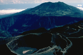 The foreground crater in this aerial photo from the SW is the principal summit crater of 3432-m-high Irazú volcano. The massive stratovolcano in the background is 3340-m-high Turrialba volcano. Roads of widely divergent quality lead to the summit craters of both these historically active volcanoes, the two highest in Costa Rica.
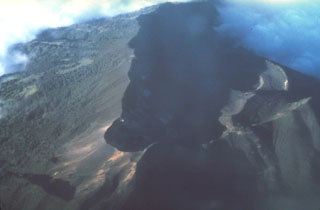 The summit crater complex of 3340-m-high Turrialba volcano appears in the shadow of this aerial view from the south. Three overlapping craters, each of which contains sub-craters, occur within the 2 x 4 km summit depression. A cloud bank at the upper right covers the breached NE end of the summit crater complex.
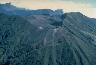 The summit crater complex of Turrialba, Costa Rica's 2nd-highest volcano, is seen here from the SW. Three overlapping summit craters are located at the apex of a large 2 x 4 km summit depression that is widely breached to the NE. The massive stratovolcano had four explosive eruptions during the past 2000 years. These produced pyroclastic flows and surges that devastated areas currently used for agricultural purposes. The most recent eruptions of Turrialba took place during the 19th century.
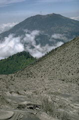 Turrialba is the SE-most Holocene volcano in Costa Rica, seen here from the upper flank of Irazú to its SW. There are three craters in the upper end of a broad summit scarp that opens towards the NE.
 Massive Turrialba volcano, seen here from the west, lies 24 km NW of the city of the same name. The stratovolcano covers an area of about 500 km2. The flanks of the volcano display youthful-looking lava flows, and historical eruptions have taken place from summit craters. Guayabo National Monument, an important archaeological park, lies at the southern base of the volcano and marks the site of human occupation that dates back to 500 BCE.
 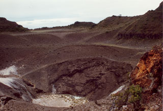 The 50-m-deep Turrialba central crater (seen here looking NE) and the SW crater were the source of a large eruption in 1866. Phreatomagmatic that year produced ashfall in Costa Rica's Central Valley for four days in January, and three days in February. Ash fell as far as Puntarenas and El Realejo in Nicaragua. Pyroclastic surges traveled more than 4 km, and small lahars traveled down the Río Aquiares and presumably other valleys.
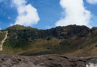 The rim of one of the three craters filling the large summit depression of Turrialba volcano is seen in the foreground. A scarp wall is visible in the background. Eruptions during the 18th and 19th centuries have originated from the three small craters.
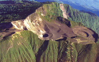 This photo shows the large scarp area that opens towards the NE (right) at the summit of Turrialba, the easternmost Holocene volcano in Costa Rica. The upper part of the scarp is partially filled by a smaller edifice with a roughly 1.3-km-wide crater, containing three smaller craters that erupted during the 18th-19th centuries. The walls of the two SW-most craters expose light-colored, hydrothermally altered rocks. Geothermal activity continues at these craters.
 The Turrialba summit crater complex is seen here from the north, with the Central Valley of Costa Rica in the background. Three well-defined craters can be seen at the upper SW end of the broad summit area. Hydrothermally altered deposits can be seen at the central and SW summit craters (right), where geothermal activity continues.
 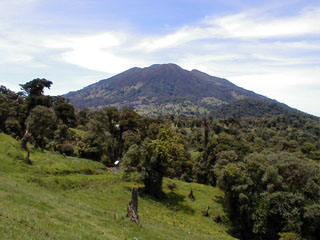 The summit of Turrialba, the easternmost volcano in the Cordillera Central, is seen here from the SW. It is about 25 km NW of the city of the same name. The summit area is designated as Turrialba National Park, and its northern flanks are part of the extensive Cordillera Volcánica Central forest reserve.
The maps shown below have been scanned from the GVP map archives and include the volcano on this page. Clicking on the small images will load the full 300 dpi map. Very small-scale maps (such as world maps) are not included. The maps database originated over 30 years ago, but was only recently updated and connected to our main database. We welcome users to tell us if they see incorrect information or other problems with the maps; please use the Contact GVP link at the bottom of the page to send us email.
The following 67 samples associated with this volcano can be found in the Smithsonian's NMNH Department of Mineral Sciences collections, and may be availble for research (contact the Rock and Ore Collections Manager). Catalog number links will open a window with more information.
| Catalog Number | Sample Description | Lava Source | Collection Date |
|---|---|---|---|
| NMNH 116066-146 | Volcanic Rock | -- | -- |
| NMNH 116066-147 | Tephra | -- | -- |
| NMNH 116066-150 | Volcanic Rock | -- | -- |
| NMNH 116066-151 | Volcanic Rock | -- | -- |
| NMNH 116066-152 | Carbonized Wood | -- | -- |
| NMNH 116066-156 | Scoriaceous Volcanic Bomb | -- | -- |
| NMNH 116066-157 | Volcanic Bomb | -- | -- |
| NMNH 116066-158 | Scoriaceous Volcanic Bomb | -- | -- |
| NMNH 116066-159 | Scoria | -- | -- |
| NMNH 116066-160 | Scoria | -- | -- |
| NMNH 116066-161 | Scoria | -- | -- |
| NMNH 116066-162 | Scoria | -- | -- |
| NMNH 116066-163 | Scoria | -- | -- |
| NMNH 116066-164 | Scoria | -- | -- |
| NMNH 116066-165 | Scoria | -- | -- |
| NMNH 116066-166 | Scoria | -- | -- |
| NMNH 116066-167 | 116066167 | -- | -- |
| NMNH 116066-168 | Scoria | -- | -- |
| NMNH 116066-169 | 116066169 | -- | -- |
| NMNH 116066-170 | Carbonized Wood | -- | -- |
| NMNH 116066-463 | Volcanic Rock | -- | 30 Apr 1985 |
| NMNH 116066-464 | Volcanic Rock | -- | 30 Apr 1985 |
| NMNH 116066-465 | Tephra | -- | 30 Apr 1985 |
| NMNH 116066-466 | Tephra | -- | 30 Apr 1985 |
| NMNH 116066-884 | Tephra | -- | 25 Jun 1985 |
| NMNH 116066-885 | Tephra | -- | 25 Jun 1985 |
| NMNH 116066-886 | Tephra | -- | 25 Jun 1985 |
| NMNH 116066-887 | Tephra | -- | 25 Jun 1985 |
| NMNH 116066-888 | Andesite | -- | -- |
| NMNH 116066-891 | Tephra | -- | 25 Jun 1985 |
| NMNH 116066-892 | Tephra | -- | 25 Jun 1985 |
| NMNH 116066-893 | Tephra | -- | 25 Jun 1985 |
| NMNH 116066-895 | Tephra | -- | -- |
| NMNH 116066-896 | Tephra | -- | -- |
| NMNH 116066-897 | Tephra | -- | -- |
| NMNH 116066-898 | Tephra | -- | -- |
| NMNH 116066-900 | Tephra | -- | -- |
| NMNH 116066-901 | Tephra | -- | -- |
| NMNH 116066-902 | Tephra | -- | -- |
| NMNH 116066-903 | Tephra | -- | -- |
| NMNH 116066-904 | Tephra | -- | -- |
| NMNH 116066-905 | Tephra | -- | -- |
| NMNH 116066-906 | Tephra | -- | -- |
| NMNH 116066-907 | Tephra | -- | -- |
| NMNH 116066-909 | Tephra | -- | -- |
| NMNH 116066-910 | Tephra | -- | -- |
| NMNH 116066-911 | Tephra | -- | -- |
| NMNH 116066-912 | Tephra | -- | -- |
| NMNH 116066-913 | Tephra | -- | -- |
| NMNH 116066-914 | Tephra | -- | -- |
| NMNH 116066-915 | Tephra | -- | -- |
| NMNH 116066-916 | Tephra | -- | -- |
| NMNH 116066-917 | Tephra | -- | -- |
| NMNH 116066-918 | Tephra | -- | -- |
| NMNH 116066-921 | Tephra | -- | -- |
| NMNH 116066-922 | Tephra | -- | -- |
| NMNH 116066-923 | Tephra | -- | -- |
| NMNH 116066-925 | Tephra | -- | -- |
| NMNH 116066-926 | Tephra | -- | -- |
| NMNH 116066-927 | Tephra | -- | -- |
| NMNH 116066-928 | Tephra | -- | -- |
| NMNH 116066-929 | Tephra | -- | -- |
| NMNH 116066-930 | Tephra | -- | -- |
| NMNH 116066-931 | Tephra | -- | -- |
| NMNH 116066-932 | Tephra | -- | -- |
| NMNH 116066-933 | Tephra | -- | -- |
| NMNH 116066-934 | Tephra | -- | -- |
| Copernicus Browser | The Copernicus Browser replaced the Sentinel Hub Playground browser in 2023, to provide access to Earth observation archives from the Copernicus Data Space Ecosystem, the main distribution platform for data from the EU Copernicus missions. |
| MIROVA | Middle InfraRed Observation of Volcanic Activity (MIROVA) is a near real time volcanic hot-spot detection system based on the analysis of MODIS (Moderate Resolution Imaging Spectroradiometer) data. In particular, MIROVA uses the Middle InfraRed Radiation (MIR), measured over target volcanoes, in order to detect, locate and measure the heat radiation sourced from volcanic activity. |
| MODVOLC Thermal Alerts | Using infrared satellite Moderate Resolution Imaging Spectroradiometer (MODIS) data, scientists at the Hawai'i Institute of Geophysics and Planetology, University of Hawai'i, developed an automated system called MODVOLC to map thermal hot-spots in near real time. For each MODIS image, the algorithm automatically scans each 1 km pixel within it to check for high-temperature hot-spots. When one is found the date, time, location, and intensity are recorded. MODIS looks at every square km of the Earth every 48 hours, once during the day and once during the night, and the presence of two MODIS sensors in space allows at least four hot-spot observations every two days. Each day updated global maps are compiled to display the locations of all hot spots detected in the previous 24 hours. There is a drop-down list with volcano names which allow users to 'zoom-in' and examine the distribution of hot-spots at a variety of spatial scales. |
|
WOVOdat
Single Volcano View Temporal Evolution of Unrest Side by Side Volcanoes |
WOVOdat is a database of volcanic unrest; instrumentally and visually recorded changes in seismicity, ground deformation, gas emission, and other parameters from their normal baselines. It is sponsored by the World Organization of Volcano Observatories (WOVO) and presently hosted at the Earth Observatory of Singapore.
GVMID Data on Volcano Monitoring Infrastructure The Global Volcano Monitoring Infrastructure Database GVMID, is aimed at documenting and improving capabilities of volcano monitoring from the ground and space. GVMID should provide a snapshot and baseline view of the techniques and instrumentation that are in place at various volcanoes, which can be use by volcano observatories as reference to setup new monitoring system or improving networks at a specific volcano. These data will allow identification of what monitoring gaps exist, which can be then targeted by remote sensing infrastructure and future instrument deployments. |
| Volcanic Hazard Maps | The IAVCEI Commission on Volcanic Hazards and Risk has a Volcanic Hazard Maps database designed to serve as a resource for hazard mappers (or other interested parties) to explore how common issues in hazard map development have been addressed at different volcanoes, in different countries, for different hazards, and for different intended audiences. In addition to the comprehensive, searchable Volcanic Hazard Maps Database, this website contains information about diversity of volcanic hazard maps, illustrated using examples from the database. This site is for educational purposes related to volcanic hazard maps. Hazard maps found on this website should not be used for emergency purposes. For the most recent, official hazard map for a particular volcano, please seek out the proper institutional authorities on the matter. |
| IRIS seismic stations/networks | Incorporated Research Institutions for Seismology (IRIS) Data Services map showing the location of seismic stations from all available networks (permanent or temporary) within a radius of 0.18° (about 20 km at mid-latitudes) from the given location of Turrialba. Users can customize a variety of filters and options in the left panel. Note that if there are no stations are known the map will default to show the entire world with a "No data matched request" error notice. |
| UNAVCO GPS/GNSS stations | Geodetic Data Services map from UNAVCO showing the location of GPS/GNSS stations from all available networks (permanent or temporary) within a radius of 20 km from the given location of Turrialba. Users can customize the data search based on station or network names, location, and time window. Requires Adobe Flash Player. |
| DECADE Data | The DECADE portal, still in the developmental stage, serves as an example of the proposed interoperability between The Smithsonian Institution's Global Volcanism Program, the Mapping Gas Emissions (MaGa) Database, and the EarthChem Geochemical Portal. The Deep Earth Carbon Degassing (DECADE) initiative seeks to use new and established technologies to determine accurate global fluxes of volcanic CO2 to the atmosphere, but installing CO2 monitoring networks on 20 of the world's 150 most actively degassing volcanoes. The group uses related laboratory-based studies (direct gas sampling and analysis, melt inclusions) to provide new data for direct degassing of deep earth carbon to the atmosphere. |
| Large Eruptions of Turrialba | Information about large Quaternary eruptions (VEI >= 4) is cataloged in the Large Magnitude Explosive Volcanic Eruptions (LaMEVE) database of the Volcano Global Risk Identification and Analysis Project (VOGRIPA). |
| EarthChem | EarthChem develops and maintains databases, software, and services that support the preservation, discovery, access and analysis of geochemical data, and facilitate their integration with the broad array of other available earth science parameters. EarthChem is operated by a joint team of disciplinary scientists, data scientists, data managers and information technology developers who are part of the NSF-funded data facility Integrated Earth Data Applications (IEDA). IEDA is a collaborative effort of EarthChem and the Marine Geoscience Data System (MGDS). |

