False Reports
False or otherwise incorrect reports of volcanic activity.
Bulletin Reports - Index
Reports are organized chronologically and indexed below by Month/Year (Publication Volume:Number), and include a one-line summary. Click on the index link or scroll down to read the reports.
August 1968 (CSLP 68:30)
Sangihe Islands: News reports of possible activity at four volcanoes
[The following reports of possible volcanic activity were received following the Northern Celebes Earthquake and resulting tsunami on 10 August 1968 that killed many people on the Northern Celebes island of Tuguan. The reports, based mostly on news organizations, are vague and were never substantiated. However, later information from the CSLP and Bulletin of Volcanic Eruptions indicated some level of activity at Banua Wuhu volcano and crater avalanches at Awu during this period that may have been the original events that caused these reports.]
Card 0018 (26 August 1968) News reports of smoking and rumbling from four volcanoes
The following was reported by Reuters News Service on 24 August 1968. "Antara reported today that four volcanoes in the Sangihe Talud island group off the northern tip of the Celebes had begun rumbling and smoking following the earthquakes."
Card 0021 (28 August 1968) News reports of ships asked to help evacuate residents
The following information was reported by the United Press International on 25 August 1968. "Ships in the Celebes Sea have been asked to help evacuate residents from the volcano-threatened Talaud and Sangi island groups. The Antara News Agency reported increased activity by four volcanoes on the area about 100 miles south of the tip of the Philippine island of Mindanao. About 200,000 people live in the island groups."
Information Contacts:
Card 0018 (26 August 1968) Reuters; Antara News Agency, Indonesia.
Card 0021 (28 August 1968) UPI; Antara News Agency, Indonesia.
September 1968 (CSLP 68:30)
Sangihe Islands: Scientist who visited the area unable to confirm activity
Card 0037 (06 September 1968) Scientific team sent to confirm volcanic activity
"Sujatno of Institute of Marine Research reports that scientific team, including Soetadi of Geophysics Section, Office of Meteorology and Geophysics, Djakarta, travelled to Celebes to investigate reported subsidence Taguan Island and volcanic activity Sangihe and Talaud islands. Confirmation of island subsidence and volcanic activity must await return of investigating team."
Card 0040 (09 September 1968) Minor seismicity continues three weeks after main shock
"...Volcanoes in the Sangihe-Talaud Island Group off the northern tip of the Celebes Islands had begun rumbling and smoking following the earthquakes. Minor earthquake activity is still being recorded in the area three weeks later, and activity of the volcanoes in the Talaud and Sangihe Island Groups are threatening the 200,000 people who live in the islands. Authorities have asked ships in the area to assist in the evacuation of residents."
Card 0043 (10 September 1968) Scientist who visited area uncertain about activity reports
"Uncertain about volcanic activity Sangihe and Talaud islands. Gunung Awu (Mount Awu) on Sangi Island was active and erupted in 1966. Will attempt obtain further information."
Information Contacts:
Card 0037 (06 September 1968) American Embassy, Djakarta, Indonesia.
Card 0040 (09 September 1968) International Tsunami Information Center, Honolulu, Hawaii, USA.
Card 0043 (10 September 1968) Soetadi, Office of Meteorology and Geophysics, Djakarta, Indonesia.
October 1976 (SEAN 01:13)  Cite this Report
Colombia: Evacuation due to possible unconfirmed eruption
A possible volcanic eruption began during the afternoon of 21 October 1976. Forty families were evacuated. No human casualties were reported, but 100 head of cattle have been killed and another 100 trapped by the activity. A lava flow was reported, but it should be noted that La Lorenza is on the Caribbean coast, in an area where mud volcanoes are common.
Information Contacts: AFP.
November 1976 (SEAN 01:14) Cite this Report
Colombia: Previously reported activity confirmed to be a mud volcano
The possible eruption reported from La Lorenza was mud volcano activity, as suspected. At 0800 on 21 October, ambient-temperature gray mud was ejected. At 0900, the petroleum gases (largely methane) emitted by the mud volcano ignited, producing a flame several hundred meters high, which lasted for several days. Contrary to press reports, no lava was emitted. People and cattle fled the area, but there were no deaths. Some livestock were injured.
Information Contacts: E. Ramirez, Univ. Javeriana, Bogotá, Colombia.
July 1983 (SEAN 08:07) Cite this Report
Papua New Guinea: Earthquake swarm; sounds and glow
"An unnamed seamount, 30 km NNE of Cape Gloucester, western New Britain, may have been the site of a short-lived eruption on 15-16 June. A subcontinuous swarm of long-period earthquakes was registered by several seismic stations in Papua New Guinea at 1913-2001 on 15 June and 0427-0450 on 16 June. The swarm was recognized when the records were analyzed at RVO in early July. Preliminary determinations indicated shallow origins over a broad area at the W extremity of New Britain.
"Inquiries with the local people resulted in accounts of sounds like a jet plane coming from the sea, and glow in the sea a long distance from the coast. Northeastward migration of the incandescence was also reported, possibly suggesting a fissure eruption. Airborne observations on 28 July failed to find water discolouration or any other evidence of the 6-week-old event.
"Until further information is obtained, the most likely source for these phenomena is a large seamount mapped in the general area of earthquake locations and visible reports."
Information Contacts: P. de Saint Ours and C. McKee, RVO.
October 1986 (BGVN 11:10) Cite this Report
Kermadec Islands: Violent underwater explosion reported
On 11 November at 0710, the yacht Nutra, traveling from Rarotonga to Auckland, was shaken violently in what was described as an underwater explosion [but see BGVN 11:11]. Disturbed sea conditions preceded the main explosion.
The reported location is ~100 km E of the trend of the Tonga-Kermadec chain, over the W edge of the Tonga Trench at its S end; 570 km NNE of Raoul Island and 380 km S of Tongatapu. We are not aware of previous reports of activity in this area. The Worldwide Standardized Seismic Network recorded no nearby earthquakes at the time, although aftershocks of the M 8.2 Kermadec Islands event of 20 October continued 400 km to the S.
Information Contacts: J. Latter, DSIR Geophysics, Wellington; NEIC.
November 1986 (BGVN 11:11) Cite this Report
Kermadec Islands: Probably an earthquake in the Tonga Trench
The 11 November submarine explosion is now believed to have been an earthquake. To persons on board the yacht Nutra, the event sounded like a dynamite blast followed by a pair of echoes with a total duration of 1 second. Intensities of the blast and echoes were estimated by crewmen at 100, 90, and 80 decibels. No pumice, ash, or water discoloration were observed.
P and S waves, apparently from this event, were recorded at Rarotonga, Cook Islands, and Mangahao, New Zealand; local magnitude was about 4.5-5. The yacht's position at the time of the event, over the W side of the Tonga Trench, was determined by satellite navigation, accurate to within ~1.5 km.
Information Contacts: J. Latter, DSIR Geophysics Division, Wellington; P. Black, Univ of Auckland, Auckland.
June 1990 (BGVN 15:06) Cite this Report
Chile: Press reports of boiling water were apparently fabricated
The press reported that a submarine volcano was suspected to be the cause of an area of boiling water, roughly 500 m in radius, reported by a fishing boat 70 km W of Papudo (60 km NNW of Valparaíso, 32.3°S, 72.30°W). Upon investigation, it was determined that the initial report had never been verified and was apparently a fabricated message. Scientists onboard the Chilean naval vessal Carlos Arevalo found no evidence of a volcano in the area, a seismically active zone on the continental slope far from any known volcanism.
Information Contacts: M. Gardeweg, SERNAGEOMIN, Santiago, Chile.
May 1997 (BGVN 22:05) Cite this Report
Mexico: Rumors of new volcano prove false; methane combustion implicated
Although mid-May speculations suggested that a new volcano might be developing in the SE part of the State of Zacatecas, the incident has been attributed to methane combustion unrelated to volcanism. The event took place near the town of Jerez, ~50 km SW of Zacatecas city. Hugo Delgado received a video made by local residents, asked officials about the event, and provided the following report.
"The place where this phenomena is happening is a flat area (a square area [~20 m on each side]) where the ground is smoking (combustion-like blue smoke). There are several cracks on the ground and inside the cracks the earth looks reddish and hot. The people who sent me the video show how a piece of wood burns [when] they put it inside the crack. The area was isolated from the curious people (crowds of families who want to see what is happening visit the place) [by] digging a furrow around the hot site and posting policemen in order to [prevent] children [from falling] into the hot cracks.
"People from the University of Zacatecas and from the SEMARNAP (Ministry of the Environment, Natural Resources, and Fisheries) have visited the area and concluded that microbial activity on concentrated organic material in the area has produced methane and this started to burn since the beginning of May. Burning of methane has [caused] the ground to glow. According to their report, no deformation of the ground has been detected, nor [were] ashes or sulfuric odors detected during their visit. Samples taken from the ground were chemically analyzed [revealing] mainly organic material in them. This kind of [incident] has occurred before in other [parts] of Zacatecas, according to SEMARNAP.
"[It] seems that somebody (unidentified, but according to the local people, it was a retired scientist [transporting] equipment) came to the region to see the phenomena, and commented that it was the birth of a volcano. Thus, the inhabitants became alarmed. Local newspapers have also published that methane is burning there according to the researchers of the University of Zacatecas.
"Officials from the National Center for Disaster Prevention (CENAPRED) knew about this event, and have received the reports from SEMARNAP and the University of Zacatecas. This has been treated not as a volcanic problem but [an] environmental [one].
"A year ago, there was a similar event in the region. Carlos Gutierrez from CENAPRED visited the zone in order to deploy seismic equipment to observe this event. It was determined that organic material (sedimentary carbon[aceous] deposit[s] in a lacustrine environment during the Pleistocene) was burning underground after the local people incinerated dry grass (a common practice in Mexico to fertilize the land before the rainy season)."
Luca Ferrari provided geological insight into the area. It is on the E flank of the Sierra Madre Occidental, a huge mid-Tertiary volcanic pile related to subduction of the Farallon Plate. Volcanic rocks in the area include extensive silicic ashflow tuffs of late Oligocene to early Miocene age; these are sometimes capped by small volumes of andesitic and basaltic lavas ~20 Ma old. The incident took place more than 200 km N of the active volcanic arc (the Mexican Volcanic Belt, related to the ongoing subduction of the Rivera and Cocos plates). Quaternary intra-plate basalts are absent within a 200 km radius of the site of the incident. From a tectonic point of view, the village of Jerez lies at the N end of the Tlaltenango graben, which formed during Basin and Range extension in the early Miocene. Tectonic activity appears to have slowed since then and no Quaternary faulting is reported in the region.
Information Contacts: Hugo Delgado, Instituto de Geofisica, U.N.A.M.Circuito Cientifico, C.U. 04510, Mexico D.F., Mexico; Luca Ferrari, Instituto de Geologia, UNAM, Apdo. Postal 376, 36000 Guanajuato, Gto., Mexico.
August 1997 (BGVN 22:08) Cite this Report
Philippines: False report of volcanism intended to exclude would-be gold miners
In discussing the week ending on 12 September, "Earthweek" (Newman, 1997) incorrectly claimed that a volcano named "Mount Pinukis" had erupted. Widely read in the US, the dramatic Earthweek report described terrified farmers and a black mushroom cloud that resembled a nuclear explosion. The mountain's location was given as "200 km E of Zamboanga City," a spot well into the sea. The purported eruption had received mention in a Manila Bulletin newspaper report nine days earlier, on 4 September. Their comparatively understated report said that a local police director had disclosed that residents had seen a dormant volcano showing signs of activity.
In response to these news reports Emmanuel Ramos of the Philippine Institute of Volcanology and Seismology (PHIVOLCS) sent a reply on 17 September. PHIVOLCS staff had initially heard that there were some 12 alleged families who fled the mountain and sought shelter in the lowlands. A PHIVOLCS investigation team later found that the reported "families" were actually individuals seeking respite from some politically motivated harassment. The story seems to have stemmed from a local gold rush and an influential politician who wanted to use volcanism as a ploy to exclude residents. PHIVOLCS concluded that no volcanic activity had occurred. They also added that this finding disappointed local politicians but was much welcomed by the residents.
PHIVOLCS spelled the mountain's name as "Pinokis" and from their report it seems that it might be an inactive volcano. There is no known Holocene volcano with a similar name (Simkin and Siebert, 1994). No similar names (Pinokis, Pinukis, Pinakis, etc.) were found listed in the National Imagery and Mapping Agency GEOnet Names Server (http://geonames.nga.mil/gns/html/index.html), a searchable database of 3.3 million non-US geographic-feature names.
The Manila Bulletin report suggested that Pinokis resides on the Zamboanga Peninsula. The Peninsula lies on Mindanao Island's extreme W side where it bounds the Moro Gulf, an arm of the Celebes Sea. The mountainous Peninsula trends NNE-SSW and contains peaks with summit elevations near 1,300 m. Zamboanga City sits at the extreme end of the Peninsula and operates both a major seaport and an international airport.
[Later investigation found that Mt. Pinokis is located in the Lison Valley on the Zamboanga Peninsula, about 170 km NE of Zamboanga City and 30 km NW of Pagadian City. It is adjacent to the two peaks of the Susong Dalaga (Maiden's Breast) and near Mt. Sugarloaf. 7.975°N, 123.23°E; summit elev. 1510 m]
References. Newman, S., 1997, Earthweek, a diary of the planet (week ending 12 September): syndicated newspaper column (URL: http://www.earthweek.com/).
Manila Bulletin, 4 Sept. 1997, Dante's Peak (URL: http://www.mb.com.ph/).
Simkin, T., and Siebert, L., 1994, Volcanoes of the world, 2nd edition: Geoscience Press in association with the Smithsonian Institution Global Volcanism Program, Tucson AZ, 368 p.
Information Contacts: Emmanuel G. Ramos, Deputy Director, Philippine Institute of Volcanology and Seismology, Department of Science and Technology, PHIVOLCS Building, C. P. Garcia Ave., University of the Philippines, Diliman campus, Quezon City, Philippines.
August 1997 (BGVN 22:08) Cite this Report
Vietnam: News report of alleged volcanic subsidence near "Ham Rong"
A 21 February Reuters news report described land subsidence near Ham Rong (Dragon's Mouth) in Gia Lai province in the central highlands of Vietnam. The report stated that several thousand square meters of cropland had subsided up to 3 m beginning between September and November 1996. The ground around the sunken patches, some of which were kilometers apart, was covered with small cracks. The news report stated that movement of underground gases was being investigated as a possible cause of the ground subsidence and that the spot lies near a volcano that has reportedly been extinct for about 1,000 years.
Attempts to corroborate this story with Vietnamese authorities having failed, we tried to ascertain the location of Ham Rong. To do this, we queried the National Imagery and Mapping Agency GEOnet Names Server, a searchable database of 3.3 million non-US geographic-feature names. No feature by the name "Ham Rong" was listed in the Gia Lai province. However, there is a mountain feature by the name "H?drông" near Pleiku-Bantour, a catalogued volcanic area at 14°N, 108°E. Pleiku-Bantour is an area of extensive basaltic lava containing five calderas and two basaltic lava cones (Whitford-Stark, 1987). A second possibility for the location of the volcanic activity is Toroeng Prong, a basaltic volcano at 14.9°N, 108°E (Whitford-Stark, 1987).
Reference. Whitford-Stark, J.L., 1987, A survey of Cenozoic volcanism in mainland Asia: Geological Society of America Special Paper 213, p. 16-19.
Information Contacts: Reuters News Service; National Imagery and Mapping Agency (NIMA), General Help Desk (L-52), 3200 South Second St., St. Louis, MO 63118-3399 USA.
December 1997 (BGVN 22:12) Cite this Report
Somalia: Press reports of Somalia's first historical eruption were likely in error
Xinhua News Agency filed a news report on 27 February under the headline "Volcano erupts in Somalia" but the veracity of the story now appears doubtful. The report disclosed the volcano's location as on the W side of the Gedo region [3.25°N, 41.667°E; summit elev. 500 m], an area along the Ethiopian border just NE of Kenya. The report had relied on the commissioner of the town of Bohol Garas (a settlement described as 40 km NE of the main Al-Itihad headquarters of Luq town) and some or all of the information was relayed by journalists through VHF radio. The report claimed the disaster "wounded six herdsmen" and "claimed the lives of 290 goats grazing near the mountain when the incident took place." Further descriptions included such statements as "the volcano which erupted two days ago [25 February] has melted down the rocks and sand and spread...."
Giday WoldeGabriel returned from three weeks of geological fieldwork in SW Ethiopia, near the Kenyan border, on 25 August. During his time there he inquired of many people, including geologists, if they had heard of a Somalian eruption in the Gedo area; no one had heard of the event. WoldeGabriel stated that he felt the news report could have described an old mine or bomb exploding. Heavy fighting took place in the Gedo region during the Ethio-Somalian war of 1977. Somalia lacks an embassy in Washington DC; when asked during late August, Ayalaw Yiman, an Ethiopian embassy staff member in Washington DC also lacked any knowledge of a Somalian eruption.
A Somalian eruption would be significant since the closest known Holocene volcanoes occur in the central Ethiopian segment of the East African rift system S of Addis Ababa, ~500 km NW of the Gedo area. These Ethiopian rift volcanoes include volcanic fields, shield volcanoes, cinder cones, and stratovolcanoes.
Information Contacts: Xinhua News Agency, 5 Sharp Street West, Wanchai, Hong Kong; Giday WoldeGabriel, EES-1/MS D462, Geology-Geochemistry Group, Los Alamos National Laboratory, Los Alamos, NM 87545, USA; Ayalaw Yiman, Ethiopian Embassy, 2134 Kalorama Rd. NW, Washington DC 20008, USA.
November 1999 (BGVN 24:11) Cite this Report
Turkey: UFO adherent claims new volcano in Sea of Marmara
Following the Ms 7.8 earthquake in Turkey on 17 August (BGVN 24:08) an Email message originating in Turkey was circulated, claiming that volcanic activity was observed coincident with the earthquake and suggesting a new (magmatic) volcano in the Sea of Marmara [40.683°N, 29.1°E]. For reasons outlined below, and in the absence of further evidence, editors of the Bulletin consider this a false report.
The report stated that fishermen near the village of Cinarcik, at the E end of the Sea of Marmara "saw the sea turned red with fireballs" shortly after the onset of the earthquake. They later found dead fish that appeared "fried." Their nets were "burned" while under water and contained samples of rocks alleged to look "magmatic."
No samples of the fish were preserved. A tectonic scientist in Istanbul speculated that hot water released by the earthquake from the many hot springs along the coast in that area may have killed some fish (although they would be boiled rather than fried).
The phenomenon called earthquake lights could explain the "fireballs" reportedly seen by the fishermen. Such effects have been reasonably established associated with large earthquakes, although their origin remains poorly understood. In addition to deformation-triggered piezoelectric effects, earthquake lights have sometimes been explained as due to the release of methane gas in areas of mass wasting (even under water). Omlin and others (1999), for example, found gas hydrate and methane releases associated with mud volcanoes in coastal submarine environments.
The astronomer and author Thomas Gold (Gold, 1998) has a website (Gold, 2000) where he presents a series of alleged quotes from witnesses of earthquakes. We include three such quotes here (along with Gold's dates, attributions, and other comments):
(A) Lima, 30 March 1828. "Water in the bay 'hissed as if hot iron was immersed in it,' bubbles and dead fish rose to the surface, and the anchor chain of HMS Volage was partially fused while lying in the mud on the bottom." (Attributed to Bagnold, 1829; the anchor chain is reported to be on display in the London Navy Museum.)
(B) Romania, 10 November 1940. ". . . a thick layer like a translucid gas above the surface of the soil . . . irregular gas fires . . . flames in rhythm with the movements of the soil . . . flashes like lightning from the floor to the summit of Mt Tampa . . . flames issuing from rocks, which crumbled, with flashes also issuing from non-wooded mountainsides." (Phrases used in eyewitness accounts collected by Demetrescu and Petrescu, 1941).
(C) Sungpan-Pingwu (China), 16, 22, and 23 August 1976. "From March of 1976, various large anomalies were observed over a broad region. . . . At the Wanchia commune of Chungching County, outbursts of natural gas from rock fissures ignited and were difficult to extinguish even by dumping dirt over the fissures. . . . Chu Chieh Cho, of the Provincial Seismological Bureau, related personally seeing a fireball 75 km from the epicenter on the night of 21 July while in the company of three professional seismologists."
Yalciner and others (1999) made a study of coastal areas along the Sea of Marmara after the Izmet earthquake. They found evidence for one or more tsunamis with maximum runups of 2.0-2.5 m. Preliminary modeling of the earthquake's response failed to reproduce the observed runups; the areas of maximum runup instead appeared to correspond most closely with several local mass-failure events. This observation together with the magnitude of the earthquake, and bottom soundings from marine geophysical teams, suggested mass wasting may have been fairly common on the floor of the Sea of Marmara.
Despite a wide range of poorly understood, dramatic processes associated with earthquakes (Izmet 1999 apparently included), there remains little evidence for volcanism around the time of the earthquake. The nearest Holocene volcano lies ~200 km SW of the report location. Neither Turkish geologists nor scientists from other countries in Turkey to study the 17 August earthquake reported any volcanism. The report said the fisherman found "magmatic" rocks; it is unlikely they would be familiar with this term.
The motivation and credibility of the report's originator, Erol Erkmen, are unknown. Certainly, the difficulty in translating from Turkish to English may have caused some problems in understanding. Erkmen is associated with a website devoted to reporting UFO activity in Turkey. Photographs of a "magmatic rock" sample were sent to the Bulletin, but they only showed dark rocks photographed devoid of a scale on a featureless background. The rocks shown did not appear to be vesicular or glassy. What was most significant to Bulletin editors was the report author's progressive reluctance to provide samples or encourage follow-up investigation with local scientists. Without the collaboration of trained scientists on the scene this report cannot be validated.
References. Omlin, A, Damm, E., Mienert, J., and Lukas, D., 1999, In-situ detection of methane releases adjacent to gas hydrate fields on the Norwegian margin: (Abstract) Fall AGU meeting 1999, Eos, American Geophysical Union.
Yalciner, A.C., Borrero, J., Kukano, U., Watts, P., Synolakis, C. E., and Imamura, F., 1999, Field survey of 1999 Izmit tsunami and modeling effort of new tsunami generation mechanism: (Abstract) Fall AGU meeting 1999, Eos, American Geophysical Union.
Gold, T., 1998, The deep hot biosphere: Springer Verlag, 256 p., ISBN: 0387985468.
Gold, T., 2000, Eye-witness accounts of several major earthquakes (URL: http://www.people.cornell.edu/ pages/tg21/eyewit.html).
Information Contacts: Erol Erkmen, Tuvpo Project Alp.
May 2003 (BGVN 28:05) Cite this Report
Mongolia: Fumaroles and minor seismicity since October 2002
In December 2002 information appeared in Mongolian and Russian newspapers and on national TV that a volcano in Central Mongolia, the Har-Togoo volcano, was producing white vapors and constant acoustic noise. Because of the potential hazard posed to two nearby settlements, mainly with regard to potential blocking of rivers, the Director of the Research Center of Astronomy and Geophysics of the Mongolian Academy of Sciences, Dr. Bekhtur, organized a scientific expedition to the volcano on 19-20 March 2003. The scientific team also included M. Ulziibat, seismologist from the same Research Center, M. Ganzorig, the Director of the Institute of Informatics, and A. Ivanov from the Institute of the Earth's Crust, Siberian Branch of the Russian Academy of Sciences.
Geological setting. The Miocene Har-Togoo shield volcano is situated on top of a vast volcanic plateau (figure 1). The 5,000-year-old Khorog (Horog) cone in the Taryatu-Chulutu volcanic field is located 135 km SW and the Quaternary Urun-Dush cone in the Khanuy Gol (Hanuy Gol) volcanic field is 95 km ENE. Pliocene and Quaternary volcanic rocks are also abundant in the vicinity of the Holocene volcanoes (Devyatkin and Smelov, 1979; Logatchev and others, 1982). Analysis of seismic activity recorded by a network of seismic stations across Mongolia shows that earthquakes of magnitude 2-3.5 are scattered around the Har-Togoo volcano at a distance of 10-15 km.
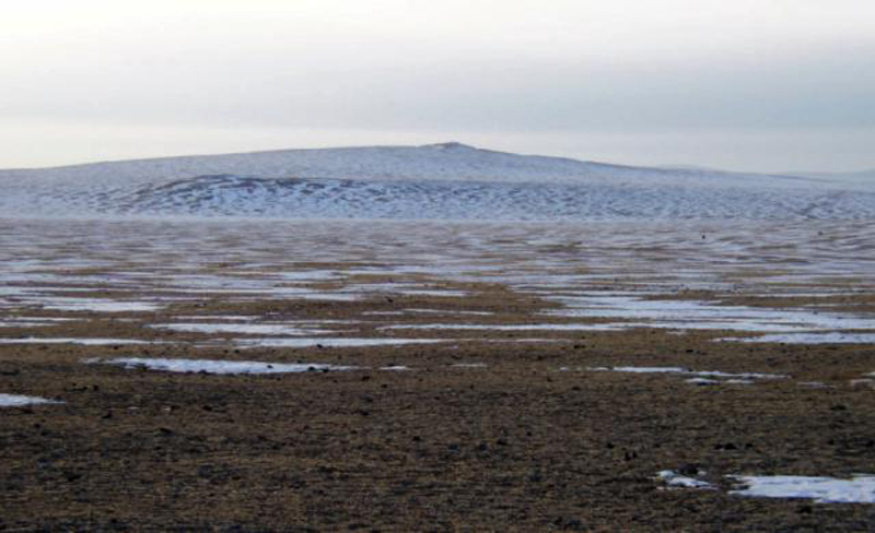 |
Figure 1. Photograph of the Har-Togoo volcano viewed from west, March 2003. Courtesy of Alexei Ivanov. |
Observations during March 2003. The name of the volcano in the Mongolian language means "black-pot" and through questioning of the local inhabitants, it was learned that there is a local myth that a dragon lived in the volcano. The local inhabitants also mentioned that marmots, previously abundant in the area, began to migrate westwards five years ago; they are now practically absent from the area.
Acoustic noise and venting of colorless warm gas from a small hole near the summit were noticed in October 2002 by local residents. In December 2002, while snow lay on the ground, the hole was clearly visible to local visitors, and a second hole could be seen a few meters away; it is unclear whether or not white vapors were noticed on this occasion. During the inspection in March 2003 a third hole was seen. The second hole is located within a 3 x 3 m outcrop of cinder and pumice (figure 2) whereas the first and the third holes are located within massive basalts. When close to the holes, constant noise resembled a rapid river heard from afar. The second hole was covered with plastic sheeting fixed at the margins, but the plastic was blown off within 2-3 seconds. Gas from the second hole was sampled in a mechanically pumped glass sampler. Analysis by gas chromatography, performed a week later at the Institute of the Earth's Crust, showed that nitrogen and atmospheric air were the major constituents.
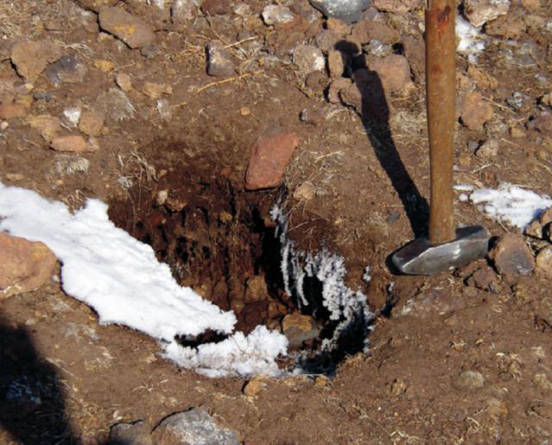 |
Figure 2. Photograph of the second hole sampled at Har-Togoo, with hammer for scale, March 2003. Courtesy of Alexei Ivanov. |
The temperature of the gas at the first, second, and third holes was +1.1, +1.4, and +2.7°C, respectively, while air temperature was -4.6 to -4.7°C (measured on 19 March 2003). Repeated measurements of the temperatures on the next day gave values of +1.1, +0.8, and -6.0°C at the first, second, and third holes, respectively. Air temperature was -9.4°C. To avoid bias due to direct heating from sunlight the measurements were performed under shadow. All measurements were done with Chechtemp2 digital thermometer with precision of ± 0.1°C and accuracy ± 0.3°C.
Inside the mouth of the first hole was 4-10-cm-thick ice with suspended gas bubbles (figure 5). The ice and snow were sampled in plastic bottles, melted, and tested for pH and Eh with digital meters. The pH-meter was calibrated by Horiba Ltd (Kyoto, Japan) standard solutions 4 and 7. Water from melted ice appeared to be slightly acidic (pH 6.52) in comparison to water of melted snow (pH 7.04). Both pH values were within neutral solution values. No prominent difference in Eh (108 and 117 for ice and snow, respectively) was revealed.
Two digital short-period three-component stations were installed on top of Har-Togoo, one 50 m from the degassing holes and one in a remote area on basement rocks, for monitoring during 19-20 March 2003. Every hour 1-3 microseismic events with magnitude
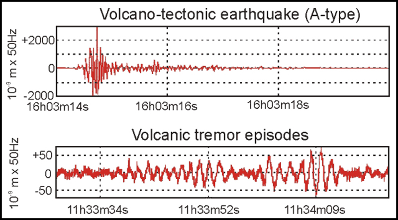 |
Figure 3. Examples of an A-type volcano-tectonic earthquake and volcanic tremor episodes recorded at the Har-Togoo station on 19 March 2003. Courtesy of Alexei Ivanov. |
Conclusions. The abnormal thermal and seismic activities could be the result of either hydrothermal or volcanic processes. This activity could have started in the fall of 2002 when they were directly observed for the first time, or possibly up to five years earlier when marmots started migrating from the area. Further studies are planned to investigate the cause of the fumarolic and seismic activities.
At the end of a second visit in early July, gas venting had stopped, but seismicity was continuing. In August there will be a workshop on Russian-Mongolian cooperation between Institutions of the Russian and Mongolian Academies of Sciences (held in Ulan-Bator, Mongolia), where the work being done on this volcano will be presented.
References. Devyatkin, E.V. and Smelov, S.B., 1979, Position of basalts in sequence of Cenozoic sediments of Mongolia: Izvestiya USSR Academy of Sciences, geological series, no. 1, p. 16-29. (In Russian).
Logatchev, N.A., Devyatkin, E.V., Malaeva, E.M., and others, 1982, Cenozoic deposits of Taryat basin and Chulutu river valley (Central Hangai): Izvestiya USSR Academy of Sciences, geological series, no. 8, p. 76-86. (In Russian).
Information Contacts: Alexei V. Ivanov, Institute of the Earth Crust SB, Russian Academy of Sciences, Irkutsk, Russia; Bekhtur andM. Ulziibat, Research Center of Astronomy and Geophysics, Mongolian Academy of Sciences, Ulan-Bator, Mongolia; M. Ganzorig, Institute of Informatics MAS, Ulan-Bator, Mongolia.
November 2004 (BGVN 29:11) Cite this Report
Andaman Islands: False reports of eruptions and confusion following the M 9 earthquake
False reports of volcanism surfaced describing eruptions at Barren Island and Narcondum volcanoes (figure 1) following the 26 December 2004, M 9 earthquake off the W coast of northern Sumatra. Clarification was provided by Dornadula Chandrasekharam of the Indian Institute of Technology. He reported an absence of volcanic activity at these volcanoes, and at Sumatran volcanoes, as recently as 4 January 2005.
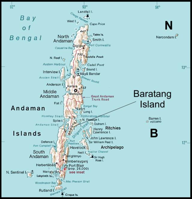 |
Figure 1. A map of the Andaman Islands showing the only volcanoes known to have erupted during the Holocene period (past 10,000 years), Narcondum and Barren Island (N and B, respectively). Note that narrow straits break Andaman island into multiple smaller islands (eg., Middle Andaman and Baratang islands). Baratang Island contains an established, studied, active mud volcano that reactivated after the M 9 earthquake. |
The erroneous accounts were discovered by Chandrasekharam while watching television news. He immediately contacted people in the Andaman region. Upon learning that these reports were incorrect, he contacted media sources and the Global Volcanism Network. Many Indian news sources that proclaimed eruptions at Barren Island later withdrew their reports. The erroneous information prevailed for a day to perhaps a week, although non-Indian news agencies were slower to recognize and acknowledge the error.
Regional tectonic setting. Figure 2 illustrates the rudiments of the regional tectonic setting, including the primary M 9 earthquake and aftershocks for the next 10 days. The tectonic reconstructions are far more complex than shown here, and the details are variously interpreted.
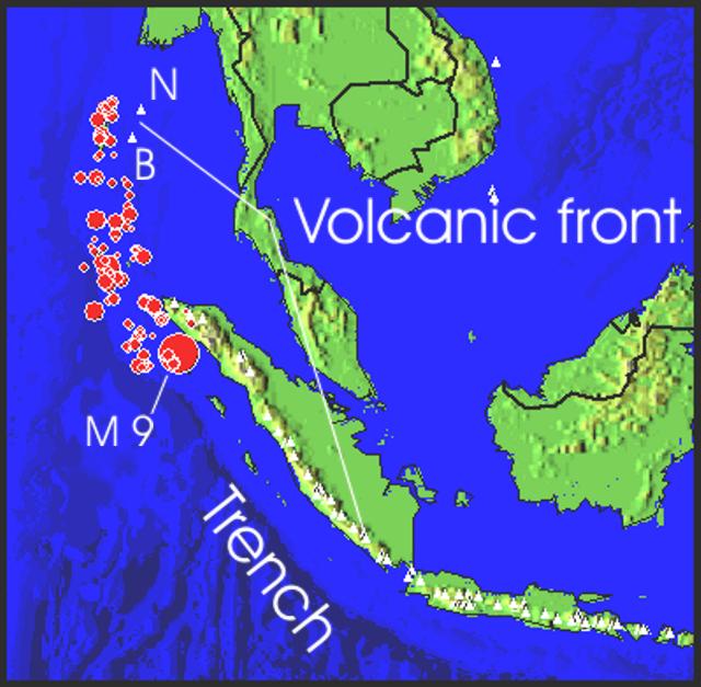 |
Figure 2. Map showing the broad tectonic setting on which Barren Island and Narcondam volcanoes reside. The map began with the main shock of the M 9 earthquake and the earthquakes that followed during the next 11 days. USGS preliminary tabulations computed the main shock as Mw 9.0 with a focus at 30 km depth. |
In terms of local time (in the Andaman Islands and India, i.e. India Standard Time), the epicenters shown occurred during the time interval 06:28:53 on 26 December to about 06:57 on 6 January. (In terms of UTC, this represents the interval 00:58:53 on 25 December to about 19:57 on 5 January 2004). This digital map was extracted by applying a video simulation of epicenters with time (Jones and others, 2002) to the recent seismic data.
The figure shows two prominent curving tectonic features crossing both Java-Sumatra and the Andaman Sea (the Nicobar and Andaman Islands region). One such curving feature is the volcanic front, on which lie all the active volcanoes of Java and Sumatra, and farther N, Barren Island and Narcondam. Outboard of that (to the W) is the second curving feature, the Sunda trench and islands adjacent to it (the Andaman Islands, and islands to the W of northern Sumatra hard-hit by the M 9 earthquake and tsunami). The trench reflects the sea-floor expression of the subduction zone, and represents the region where the M 9 earthquake occurred. The offset, often termed a 'megathrust,' involved 1,200 km of rupture along the subduction zone, and suddenly shifted the Indian Ocean's floor ~15 m towards Sumatra (Hopkin, 2005).
Regarding the M 9 earthquake, according to the USGS, the local time and date in terms of local time in N Sumatra at the epicenter was Sunday, 26 December 2004 at 07:58:53 (i.e., roughly 8 am). The USGS provided a table showing the time of the main shock in a variety of time zones.
Some excellent tutorials have provided background on the tectonic setting, the earthquake, and the tsunami. These have appeared in the press and on the web (eg. Sieh, 2004, 2005; NOAA, http://www.noaa.gov/tsunamis.html). Although large earthquakes may trigger volcanism (Linde and Sacks, 1998), so far this does not appear to be the case, at least at the volcanoes of Barren Island and Narcondum.
Mud volcanoes and ensuing confusion. Post-earthquake reports of active 'mud volcanoes' in the Andaman Islands caused panic and confusion in the region, and came at a particularly bad time. Chandrasekharam pointed out that in Andaman, like many other arc provinces, several mud volcanoes are present. These are not real volcanoes in the usual sense, but because they may build a small, low-profile cone of local extent around the hole through which the mud is thrown out, they are known as mud volcanoes (figure 3).
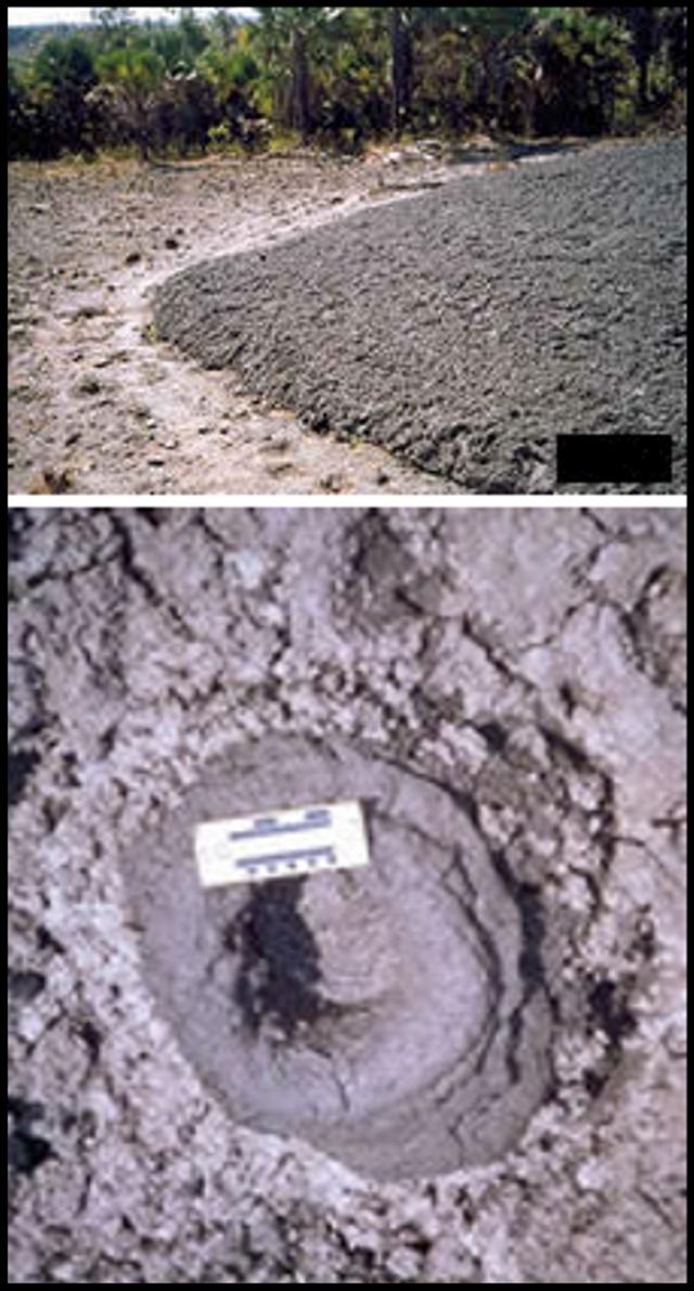 |
Figure 3. A 2003 photograph showing about a quarter to one half of a mud volcano on Baratang island (top) and its largest crater (~20 cm in diameter, ~ 28 cm in depth) (bottom). This site was known as a minor fissure prior to 1983; but in that year the largest outburst occurred, chiefly emitting warm (~ 30°C) mud. Mud again began emerging in February 2003. The dominant feature was a sub-circular mound of mud, ~30 m in diameter with a height of ~2 m at the center. Observers noted a colorless, sulfurous smelling gas. The mud contained angular to sub-rounded rock fragments from underlying strata. No photos nor similarly detailed technical reports have been received showing alleged recent activity that began 27 December 2004 (see text for news report). All photos and data courtesy of the Geological Survey of India, Eastern Region. |
Some of the difficulty with the news reports was that the mud volcanoes' locations, numbers, and impacts remained vague, and that Barren Island became intertwined with story. An extreme example came from an irresponsible report in the tabloid India Daily(2 January 2005), which contained the title "Volcano[es] Barren-1 and Narcondam erupt in Andaman—Seismic disturbance can cause more tsunami." It continued with wild claims such as, "Severe seismic activities are seen in these islands... personnel who have reached these remote areas are facing shattering earth vibrations and high waves," and "Some scientists are predicting severe earthquake again in the North of Andaman Nicobar Islands. The effect can be severe on Myanmar, Andaman, Indi[a]'s east coast, Bangladesh and Sumatra...." They added, "Andaman's tribals strangely are unaffected as most of them somehow went [to] higher ground before the tsunami. So did the animals." Science journalism clearly has a lot to compete with (see Oldenburg, 2005, for more discussion of these topics).
One alleged mud volcano 'Barren-1' has a name so close to the volcano's name (Barren Island) that it was frequently confused. The mud volcano's name (if there is one) appears to be absent from the technical literature at the Geological Survey of India's website.
On a positive note, one mud volcano received consistent mention in a number of news articles and provided coverage generally congruent with geological data posted by the Geological Survey of India. According to an article in India News(with the leader, "Port Blair, 30 December"), "A mud volcano at the inhabited Baratang Island in Middle Andaman has erupted but the administration said there was no cause for concern. 'Mud keeps bubbling in the volcano, but on December 28, the eruption was up to three meters and there was considerable heat,' Inspector General of Police S. B. Deol said here."
"He [also] said the mud volcano was located on one side of the Baratang Island, which was about 100 km from Port Blair. People live on the other side, but there is no cause for concern."
A report in the India Dailywas nearly identical. Details on a Geological Survey of India website noted that the Baratang mud volcano began erupting on 27 December 2003 (figure 3 and caption). Mud volcanoes may have also occurred elsewhere in the region, but the available news reports consistently failed to disclose locations.
Often associated with active faults and with petroleum fields, mud volcanoes on land consist of low-lying surface mud extrusions that vary in size from meters to several kilometers across. They emit mud at temperatures significantly below magmatic, which are typically at least 800°C. Eruptions from mud volcanoes can reach heights of several hundred meters and consist of mud, fluids and gases, and sometimes burning hydrocarbons. Although in submarine environments mud volcanoes can be extensive, deadly mud volcano eruptions are extremely rare because their eruptions seldom move far enough to affect large areas of the land surface. Their greatest danger may be to curious onlookers who venture too close.
References.Jones, A., Siebert, L., Kimberly, P., and Luhr, J.F., 2002, Earthquakes and Eruptions, v. 2.0 (CD-ROM): Smithsonian Institution, Global Volcanism Program, Digital Information Series, GVP-2.
Hopkin, M., 2005, Triple slip of tectonic plates caused seafloor surge: Nature, v. 433, no. 3 (06 Jan 2005).
Linde, A.T., and Sacks, I.S., 1998, Triggering of volcanic eruptions: Nature, v. 395, p. 888-890.
Oldenburg, D., 2005, A sense of doom: Animal instinct for disaster—Scientists investigate wildlife's possible warning systems: The Washington Post (8 January 2005), p. C1, C3 (URL: http://www.washingtonpost.com/).
Sieh, K., 2004, The science behind the Aceh earthquake: Caltech Media Relations (30 December 2004), (URL: http://pr.caltech.edu/media/Press_Releases/PR12628.html).
Sieh, K., 2005, In Sumatra: Notes From a Geologist in the Field: Caltech Today (1 January 2005, URL: http://today.caltech.edu/today/).
U.S. National Earthquake Information Center (NEIC) (URL: https://earthquake.usgs.gov)./
U.S. National Oceanic and Atmospheric Administration (NOAA) (URL: http://www.noaa.gov/tsunamis.html).
Information Contacts: Dornadula Chandrasekharam, Department of Earth Sciences, Indian Institute of Technology, Bombay 400076, India; India News (URL: http://news.newkerala.com/india-news/); India Daily (URL: http://www.indiadaily.com/); The Washington Post, Washington DC, USA (URL: https://www.washingtonpost.com/); Geological Survey of India, 27 Jawaharlal Nehru road, Kolkata (Calcutta) 700016, India.
December 2005 (BGVN 30:12) Cite this Report
Uganda: False report of activity; confusion caused by burning dung in a lava tube
An eruption at Mount Elgon [1.136°N, 34.559°E; summit elev. 3,885 m] was mistakenly inferred when fumes escaped from this otherwise quiet volcano. The fumes were eventually traced to dung burning in a lava-tube cave. The cave is home to, or visited by, wildlife ranging from bats to elephants. Mt. Elgon (Ol Doinyo Ilgoon) is a stratovolcano on the SW margin of a 13 x 16 km caldera that straddles the Uganda-Kenya border 140 km NE of the N shore of Lake Victoria. No eruptions are known in the historical record or in the Holocene.
On 7 September 2004 the web site of the Kenyan newspaper The Daily Nation reported that villagers sighted and smelled noxious fumes from a cave on the flank of Mt. Elgon during August 2005. The villagers' concerns were taken quite seriously by both nations, to the extent that evacuation of nearby villages was considered.
The Daily Nation article added that shortly after the villagers' reports, Moses Masibo, Kenya's Western Province geology officer visited the cave, confirmed the villagers observations, and added that the temperature in the cave was 170°C. He recommended that nearby villagers move to safer locations. Masibo and Silas Simiyu of KenGens geothermal department collected ashes from the cave for testing.
Gerald Ernst reported on 19 September 2004 that he spoke with two local geologists involved with the Elgon crisis from the Geology Department of the University of Nairobi (Jiromo campus): Professor Nyambok and Zacharia Kuria (the former is a senior scientist who was unable to go in the field; the latter is a junior scientist who visited the site). According to Ernst their interpretation is that somebody set fire to bat guano in one of the caves. The fire was intense and probably explains the vigorous fuming, high temperatures, and suffocated animals. The event was also accompanied by emissions of gases with an ammonia odor. Ernst noted that this was not surprising considering the high nitrogen content of guano—ammonia is highly toxic and can also explain the animal deaths. The intense fumes initially caused substantial panic in the area.
It was Ernst's understanding that the authorities ordered evacuations while awaiting a report from local scientists, but that people returned before the report reached the authorities. The fire presumably prompted the response of local authorities who then urged the University geologists to analyze the situation. By the time geologists arrived, the fuming had ceased, or nearly so. The residue left by the fire and other observations led them to conclude that nothing remotely related to a volcanic eruption had occurred.
However, the incident emphasized the problem due to lack of a seismic station to monitor tectonic activity related to a local triple junction associated with the rift valley or volcanic seismicity. In response, one seismic station was moved from S Kenya to the area of Mt. Elgon so that local seismicity can be monitored in the future.
Information Contacts: Gerald Ernst, Univ. of Ghent, Krijgslaan 281/S8, B-9000, Belgium; Chris Newhall, USGS, Univ. of Washington, Dept. of Earth & Space Sciences, Box 351310, Seattle, WA 98195-1310, USA; The Daily Nation (URL: http://www.nationmedia.com/dailynation/); Uganda Tourist Board (URL: http://www.visituganda.com/).
March 2012 (BGVN 37:03) Cite this Report
Pakistan: Peculiar activity emitted less than 5 m3 of frothy basalt
According to a report by Rana and Akhtar (2010) of the Geological Survey of Pakistan (GSP), an M 3.9 earthquake with a focal depth of 60 km occurred on 27 January 2010. It was accompanied by "spewing of molten material, burning of rock fragments, emission of steam, sparks and fumes in Sari (Charri) near Wam (Waam) in Ziarat Valley . . .. The molten material expelled from a small scoria cone and four smaller fissures in Tor Zawar mountain." The village of Wam was devastated on 29 October 2008 when a severe earthquake (M 6.2, focal depth 10 km) hit the city of Ziarat (~28 km ESE from Wam). [Note - Throughout this report we have tried to use the spelling of geographic and geologic features as found in the GSP report, with alternative spellings found in other referenced reports placed in parentheses.]
The frothy basalt emitted at Tor Zawar occurred at a spot located hundreds of kilometers from the nearest known Holocene volcanism. The news and various discussions of the site incorrectly attributed the eruption to activity at a mud volcano, a process common in the region. This may be the smallest volume eruption ever documented at a new locality.
Figure 1 shows a geological sketch map of the area of Balochistan Province, Pakistan, where the eruption occurred. The news of volcanic activity was surprising because volcanism has seemingly been absent here for at least the last 10,000 years. The closest identified Holocene volcanoes occur ~400 km N in Afghanistan (Vakak Group and Dacht-Navar Group) and ~800 km W in Iran (Taftan, Bazman, and unnamed volcanoes; figure 2).
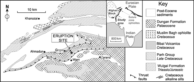 |
Figure 1. Geological sketch map showing the location of the eruption site at Tor Zawar, Pakistan, on 27 January 2010. The site is in the Sari (alternatively Jhari, Charri, or Cherri) area of the Ziarat District of Balochistan Province ~10.6 km N of the village of Wam (Waam). The event took place ~55 km NW of Quetta, Pakistan (~70 km E of the border with Afghanistan) and ~8.1 km E of the town of Gogai. The geological formations on the map are keyed to the stratigraphic section on the right-hand side of the figure. From Kerr, Khan, and McDonald (2010), modified from Khan, Kassi, and Khan (2000). |
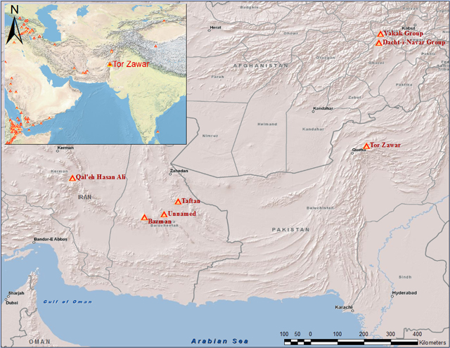 |
Figure 2. Map of the Pakistan-Afghanistan-Iran region showing the relative locations of known Holocene volcanoes with respect to the Tor Zawar event. Of those Holocene volcanoes shown, only Taftan volcano in Iran has possible historically recorded eruptions, which occurred in 1902 and 1993. Locations from Siebert and others (2010); map produced by S. Purcell (GVP). |
News reports from several sources (e.g., The Nation, 3 February 2010; Balochistan Times, 23 February 2010 and 7 March 2010; Ary News, 2 February 2010) noted that residents in nearby areas observed flames at the mountain top for several nights and, on 1 February 2010, the volcano began erupting lava. Explosions followed by smoke emissions were observed. District Coordinator Officer Siddiq Mandokhel confirmed that lava spewed from the volcano. The newspaper Pak Tribune reported on 3 February 2010 that Mandokhel said "he had personally surveyed the site of occurrence, and said that emittance of chemical gases had begun last night, after which it spewed out a molten lava, the size of a meter".
At least two small groups of earth scientists visited the site within 3 to 5 days after the reported 'eruption' event. The field observations by scientists from the GSP were reported in a GSP Information Release (Rana and Akhtar, 2010). Khadim Durrani (2010) issued on his web site an illustrated interview conducted with Din Mohammed Kakar. The two reports mentioned above contain occasional discrepancies within and between the reports, and both include unlabeled figures. During the periods of field observations, no fresh extrusion of volcanic material or sparks was observed. However, heat was still being emitted.
Table 1 contains a brief summary of possible causes and/or production-mechanisms for the molten material that have been suggested by various sources. Additional details are found in sections below.
Table 1. Various explanations for a molten material source and proposed mechanism of erupted surface deposit at Tor Zawar. See original papers for more details.
| Proposed source or mechanism | Comments |
| Melting of existing Bibai volcanics caused by resistive heating due to local power line, lightning, or some combination of surface sources. | Mentioned but dismissed by Rana and Akhtar (2010); 'unsupported' according to Kerr and others (2010; Kakar, in Durrani (2010). |
| Frictionally derived melting along thrust fault. | Rana and Akhtar (2010). |
| Methane gas leakage and flaring with local heating/melting of existing Bibai volcanics. | Bilham (personal communication). |
| Rupture on Gogai Wam fault during 2008 earthquake created chambers from which molten materials rose and eventually erupted through channels in the weak zone. | Rana and Akhtar (2010). |
| Melting from heating of lithosphere either by conduction from below or by advection from an intruding magma. | "It is more likely that a small amount of asthenospheric-derived melt has invaded the lower lithosphere," concluded Kerr and others (2010). |
| 60-80 km deep magma ascended to the surface along Bibai and Gogai thrust faults. | "Eruption represents a geological event of deep origin," according to Kerr and others (2010). |
Field observations by GSP. Two GSP geoscientists, Asif Nazeer Rana and Sardar Saeed Akhtar, visited the site of the molten material (figure 3) on 2 February 2010 and summarized their observations in a GSP report (Rana and Akhtar, 2010). The following information came from that report. Note that most of the figures reproduced below from the GSP report lacked captions.
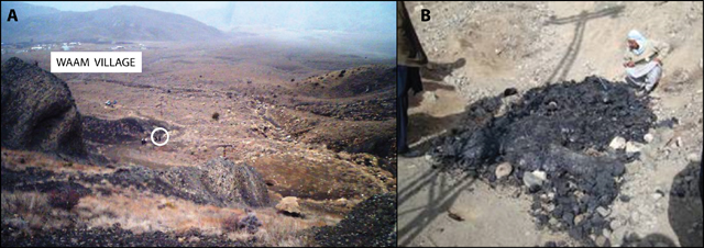 |
Figure 3. Photo of the study site (a) and deposit of solidified molten material (b). The circled area in 'a' shows the location of the molten material deposit. The surrounding dark colored rocks are part of the Cretaceous Bibai Volcanics. The village of Wam (Waam) is visible in the upper part of the picture. Note in figure 'b' the shadow of nearby overhead power lines. Photo 'a' by Din Mohammed Kakar in Durrani (2010); photo 'b' courtesy of Rana and Akhtar (2010). |
The investigators were told on 2 February 2010 by locals that emission of black, molten material started along with tremors on the night of 27 January 2010. The locals observed that steam was continuously emitted from six fissures, and rock fragments were too hot to handle with bare hands. The erupted molten material (looking like lava, scoria and volcanic glass) was found to be cold and solidified on the surface (figures 4 and 5), but was still hot in the subsurface. Heat was still rising from the site during the 3 days of observation.
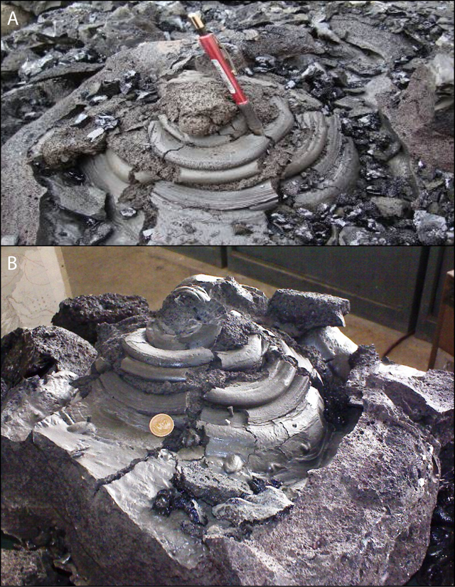 |
Figure 4. (a) Photo of the ejecta cone seen at the surface in the field. Scale provided by red-handled marker pen. Courtesy of Rana and Akhtar (2010). (b) Photo of the ejecta cone removed from the field; some breaking and/or displacement of parts of the cone is apparent. Coin shown was of unknown diameter. Photo courtesy of Kakar, in Durrani (2010). |
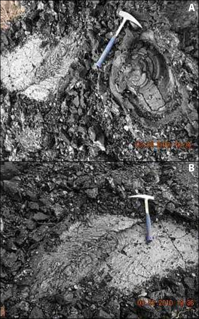 |
Figure 5. Two photos showing the eruption site and the in situ chilled molten material; geological hammers for scale. Courtesy of Rana and Akhtar (2010). |
The molten material flow solidified in concentric layers on reaching the surface (figure 4). The flow structure was ~15 m2 in area and 15 to 60 cm thick. By 2 February, most of the material had been removed as souvenirs by the locals. Rana and Akhtar (2010) reported that the dimension of the lava structure was "1.9 m x 8.2 m in length and 15 cm to 0.6 m thick." The material remaining on the surface after pilferage "was 2.9 m long and 1.5 m wide," covering a area of ~4.3 m2. The ejecta cone was formed from the molten material; the vent pipe of the cone was 0.9 m deep below the surface, but upon excavation it was observed that the cone widened and became inclined below the surface (figure 6).
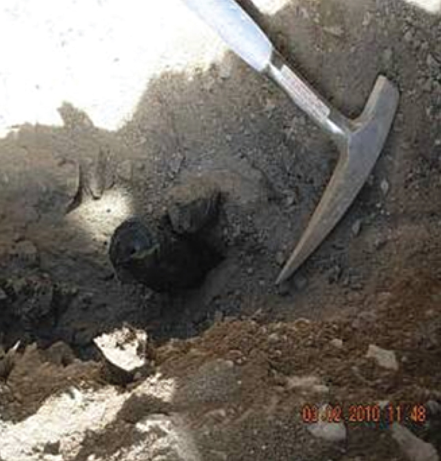 |
Figure 6. Photo of the volcanic pipe from which the ejecta cone in figure 4 was extracted; geological hammer shown for scale. Courtesy of Rana and Akhtar (2010). |
The ejected molten material and ejecta cone were excavated. A ditch was dug along the fissures to find the opening of the vent. The solidified sheet of this molten material was removed from the surface after documentation, measurement, and photography. Samples of various volcanic materials, including volcanic glass, scoria, pumice, and lava, were collected for lab analyses and petrographic studies. The newly erupted material at the surface was removed, and the complete structure of the ejecta cone was preserved and packed for display in the GSP Museum of Earth Sciences (figure 7). Deeper areas were excavated, a pipe-shaped feature was discovered at a depth of 1 m, leading down to a cone-shaped vent.
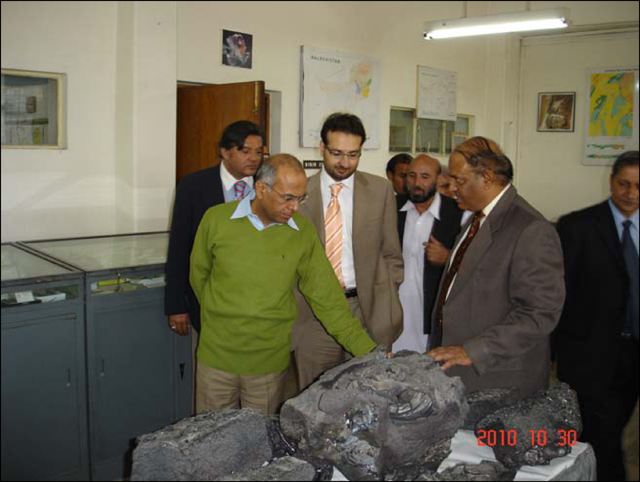 |
Figure 7. Lava excavated from vent on display at the GSP Museum of Earth Sciences. On the right is Imran Khan, Director General of GSP; on the left front in green sweater is Imtiaz Kazi, Federal Secretary, Ministry of Petroleum and Natural Resources. From GSP 2010-2011 Annual Report. |
The cone-shaped vent was fused shut by the solidification of the material in the orifice. Under the ejecta cone, a pipe of 1 m length and 5 cm diameter led vertically down to a funnel-shaped structure (i.e., wider at the top). The ejecta cone was found to be hollow on breaking the pipe and edifice; the structure looked like an oven, with a shiny, black, fine coating on the walls all around. The cone was underlain by two chambers oriented in the NW-SE direction; dimensions of these chambers were not disclosed.
The temperature of the chamber walls was still burning hot, and when dry bushes were put on the mouth of these chambers, they caught fire. The team did not carry a device for measuring soil temperature and steam from the chambers. The smaller, deeper chamber, ~4.75 m from the main chamber, led SE towards an electric power line pole. The temperature of the smaller chamber was seemingly higher than that of the main chamber. The walls of the chambers were still too hot to touch even 10 days after the lava eruption.
Two rock samples, one described as glassy and one as spongy, collected from the Tor Zawar formerly molten material were analyzed chemically at the GSP Geoscience Advance Research Laboratories for major and trace elements chemistry. Analysis revealed sample compositions of silica (SiO2) of 48.02 and 48.27 wt % and total Na2O+K2O of 5.18 and 5.23 wt. %. The two samples were classified as alkaline basalt (based on classification of Cox, Bell, and Pankhurst, 1979).
The depth of the 27 January 2010 M 3.9 earthquake was reported by the Pakistan Meteorological Department to be 60 km. The investigators found this depth to be quite unusual, as a majority of the tremors in this region have had their origin at shallow depths, generally 10-12 km. It was inferred from the previous seismotectonic investigations of 29 October 2009 earthquake (Rana, Sardar, and Qadir, 2008) that earthquake intensities and the alignment and location of most of their epicenters in this area indicated that a blind fault might be running between Gogai and Wam, passing in close proximity to this erution. There is a strong possibility that the present eruption might have occurred close to the fault plane. This blind fault, the Gogai-Wam fault, is suspected to run for nearly 40 km NW-SE, but no trace of any surface rupture was recorded either in the previous study or in the present study.
Visit and assessment by Din Mohammad Kakar. Khadim Durrani interviewed Din Muhammad Kakar, a sedimentary geologist from the University of Balochistan, about his visit and impressions of the site (Durrani, 2010). Kakar noted that a new, small volcano began spewing lava on 29 January 2010 in Pakistan (rather than the 27 January start date reported in the GSP report above). He visited the site on "day 5 after the start of the volcanic activity" (from this, one might infer that his observations were made on 3 February). Kakar observed little molten material other than two "volcanic vents," 2-3 m apart, and the 2-m-deep pit that was dug out by the GSP (figures 8 and 9). He discovered that the GSP and the Frontier Corps (figure 10) had earlier removed parts of the newly erupted cone and the remaining debris. Kakar noted that the heat of the presumed volcanic activity could still be felt in the openings.
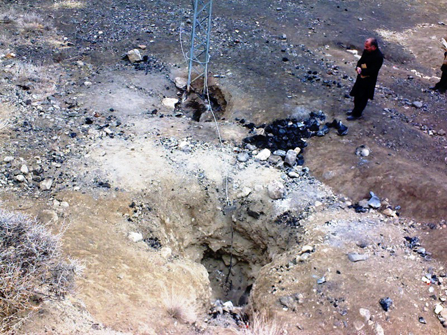 |
Figure 8. Photo of the two volcanic vents (pits/holes/chambers) and scattered pumice fragments. Note the presence of electrical cables and the foot of a power pole, with grounding wire and stake. Photo by Din Mohammed Kakar; courtesy of Durrani (2010). |
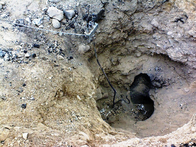 |
Figure 9. A close-up view of one of the vents with grounding wire and ground in figure 8. Photo by Din Mohammed Kakar; courtesy of Durrani (2010). |
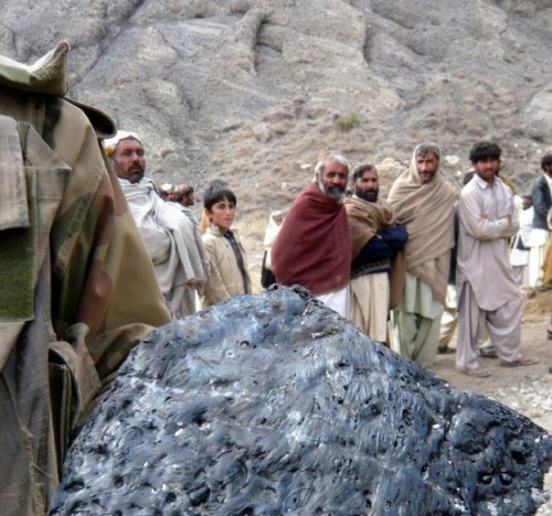 |
Figure 10. Photo of Pakistan Frontier Corps soldier taking away a large piece of the solidified molten material. Photo published 3 February by European Press Agency; courtesy of Durrani (2010). |
According to an Email note from Kakar to Bulletin editors, the chemistry indicates the same alkali basaltic lava as is found in the Bibai volcanics. Kakar noted that the eruption took place within the Late Cretaceous Bibai formation volcanics (see figure 1) (Kahn, 1998). Other exposed rocks in the area include the Parh group (Cretaceous), Dungan formation (Paleocene), and the Ghazij formation (Eocene). In the Kach-Ziarat area, the Bibai formation is sandwiched between Dungan limestone (above) and the Parh formation (below).
Eye witnesses said that there were flames coming out from the vent, possibly the result of ignited natural gas. In discussion with Bulletin editors, Roger Bilham of the University of Colorado offered the possible explanation that the eruption may have represented the remelting of pre-existing rocks of Bibai Volcanics due to ignition and combustion of natural gas.
Kakar said that the regional tectonics and the volcano's origin were not clear. However, the volcano was not a mud volcano, common in Pakistan. There is the possibility of a partial melting at shallow depth due to recent earthquake activities. He recalled the area had been hit by thousands of aftershocks since October 2008. He noted that his research had found a rupture in the basement rock below the 15-km sedimentary cover, and suggested that reactivation of the Bibai thrust might have been responsible for the recent volcanic activity. According to Kakar, the area is sparsely populated and the eruption caused no damage except for cables and poles associated with a tube well used for agricultural purposes.
Petrographic analyses.Two rock samples were sent by the GSP to Cardiff University and analyzed by Kerr and others (2010). The samples showed two petrographically distinct basalt types (figure 11). One type (sample P2) consisted of completely fresh, light brown glass with a few (
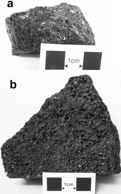 |
Figure 11. Photographs of the 2010 Tor Zawar samples analyzed by Kerr and others (2010). (a) devitrified sample (P1); and (b) glassy sample (P2). Courtesy of Kerr and others (2010). |
According to Kerr and others (2010), these two rock types "also have slightly different geochemical signatures that can be partially explained by crustal assimilation. Re-melting of local basaltic rocks by short circuiting of a ruptured high-tension electrical cable is considered unlikely. Mantle melt modeling suggests that the lavas have been largely derived from a source in the garnet-spinel transition zone, i.e. well within the lithosphere [i.e., melt from a depth of 60-80 km]. It is proposed that localized asthenospheric melting resulted in relatively depleted melts which were substantially contaminated by [a] fusible lithospheric mantle en route to the surface. Further small-scale eruptions cannot be ruled out."
Recent geophysical research. In the last week of March 2010, the GSP conducted a geophysical survey in the region of the Tor Zawar vent site (Saeed, Rehman, and Abbas, 2011). According to the report, "The syntheses of the magnetic, resistivity soundings and profiling and ground penetration radar (GPR) survey indicate the presence of highly magnetic dual lobe sources, resistive and prominent reflectors from the radar soundings in and around the vent site. The resistivity pseudo sections delineate the lateral and vertical molten flows which have apparently solidified at shallow depth."
The report concluded that "the radar imaging explicitly shows folding of the overlying fine grained clastics", and that they also saw "fracturing in the compact, hard and brittle rock units of compact gravels/limestone and volcanics due to the pressure exerted by the intrusion."
The presence of older volcanic rocks in the area made it difficult to separate older volcanic rocks and structures from the present eruption activity. The geophysical survey was unable to resolve the source or sources of the molten material that erupted as basalt.
References. Cox, K.G., Bell, J.D., and Pankhurst, R.J., 1979, The interpretation of igneous rocks, George Allen and Unwin, Boston, 450 pp.
Durrani, K., 2010, Ziarat's volcanic coughing - an interview with Din Mohammed Kakar, published by admin, March 2, 2010 in Environment, Geology of Pakistan and Natural Disasters, URL: www.khadimsquetta.com/?p=640. (Note that many of the photos in this website item are not described or labeled.)
Geological Survey of Pakistan (GSP), 2011, GSP Year Book 2010-2011, on GSP web site: http://www.gsp.gov.pk.
Kakar, D.M., Szeliga, W., and Bilham, R., 2010, Seismic Potential of the Pishin/Mach Shear Zone in Northern Baluchistan, Pakistan, Seismological Research Letters, v. 81, no. 2, pp. 324.
Khan, A.T., 1998, Sedimentology and petrology of the volcaniclastic rocks of the Bibai Formation, Ziarat District, Balochistan, Pakiston, Thesis, University of Balochistan, Quetta, 179p.
Khan, A.T., Kassi, M.T. and Khan, A.S., 2000, The Upper Cretaceous Bibai submarine Fan (Bibai Formation), Kach Ziatrat Valley, western Suleiman Thrust-Fold Belt, Pakistan, Acta Mineralogica Pakistanica, v. 11, pp. 1-24.
Kerr, A.C., Khan, M., and McDonald, I., 2010, Eruption of basaltic magma at Tor Zawar, Balochistan, Pakistan on 27 January 2010: geochemical and petrological constraints on petrogenesis, Mineralogical Magazine, v. 74, no. 6, pp. 1027-1036.
MonaLisa, and Jan, M.Q., 2010 (10 January), Geoseismological study of the Ziarat (Balochistan) earthquake (doublet?) Of 28 October 2008, Current Science, v. 98, no. 1, p. 50-57.
Rana, A.N., Sardar, S.A., and Qadir, G.T., 2008, Seismotectonic investigations of October 29, 2008 earthquake of Gogai Ziarat, Balochistan, Information Release No. 874, Geological Survey of Pakistan, Islamabad.
Rana, A.N., and Akhtar, S.S., 2010, Preliminary Report on Eruption of Molten Material in Tor Zawar Mountain, Sari, Ziarat, Balochistan on January 27, 2010, Information Release No. 891, Geological Survey of Pakistan, Islamabad, 24 pp. (Summarized in GSP News. V. 17, no. 1-12, p. 12.) (Note that many of the photos in this website item are not described or labeled.)
Saeed, M., Rehman, M., and Abbas, S.A., 2011, Integrated geophysical modeling of volcanic eruption at Tor Zawar, Ziarat, Balochistan, Information Release No. 920, Geological Survey of Pakistan, Islamabad, 79 pp.
Siebert, L., Simkin, T., and Kimberly, P., 2010, Volcanoes of the World, Third Edition, Smithsonion Institution, Washington, D.C., and University of California Press, Berkeley, CA, 551 pp.
Information Contacts: Imran Khan, Director General, Geological Survey of Pakistan, Sariab Road, Quetta, Pakistan (URL: http://www.gsp.gov.pk); Din Mohammed Kakar, Geology Department, University of Balochistan, Quetta, Pakistan (URL: http://www.uob.edu.pk/); Andrew C. Kerr, Cardiff University, School of Earth and Ocean Sciences, Cardill, Wales, UK (URL: http://www.Cardiff.ac.uk/earth/contactsandpeople/profiles/kerr-andrew.html); Khadim Durrani; Roger Bilham, University of Colorado.