Etna (Italy) | 9 April-15 April 2025 | New Activity / Unrest
 Cite this Report Cite this Report
|
 Etna Etna
Sicily Volcanic Province
|
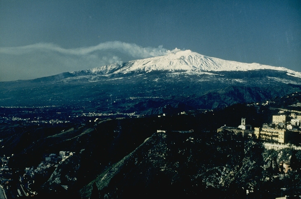
The Sezione di Catania - Osservatorio Etneo (INGV) reported continuing activity at Etna during 7-15 April. All the summit craters were characterized by degassing during the week and Strombolian activity was reported at SE Crater during 7-8, 11, and 15 April. At around 2300 on 7 April explosive activity produced a plume that drifted SE and resulted in ashfall in both Catania (29 km SSE) and Nicolosi (16 km S). At 0040 on 8 April a lava effusion began, with a flow descending the S flank. According to a Skysat image from 11 April, the lava flow covered an area of 14,000 m2, was 500 m long, and reached an elevation of 3 km (9,800 ft) a.s.l. Another Strombolian event began around 1400 on 11 April, though weather conditions prevented clear views of the summit. An active lava flow observed on the E flank around 2000 on 11 April had stopped by midnight. An ash plume during this time extended SE and resulted in light ashfall in Lavinaio, Acireale (20 km SE), and Aci San Antonio (18 km SE). By 12 April Strombolian activity was no longer observed. On 15 April Strombolian activity resumed at SE Crater, accompanied by moderate ash emissions, based on webcam images and INGV-OE personnel in the field.
Source: Sezione di Catania - Osservatorio Etneo (INGV)
|
Klyuchevskoy (Russia) | 9 April-15 April 2025 | New Activity / Unrest
Cite this Report
|
 Klyuchevskoy Klyuchevskoy
Eastern Kamchatka Volcanic Arc
|
The Tokyo VAAC reported ash plumes from Klyuchevskoy that rose to 6 km (19,700 ft) a.s.l. and drifted W at 1949 and E at 2050 on 8 April. The Institute of Volcanology and Seismology (IVS) of the Far Eastern Branch of the Russian Academy of Sciences (FEB RAS) reported that an ash plume rose 500 m and drifted E on 9 April. IVS reported an Aviation Color Code of Yellow (the second lowest level on a four-color scale) on 9 April and Green (the lowest level on a four-color scale) the rest of the week.
Sources: Institute of Volcanology and Seismology (IVS) of the Far Eastern Branch of the Russian Academy of Sciences (FEB RAS), Tokyo Volcanic Ash Advisory Center (VAAC)
|
Poas (Costa Rica) | 9 April-15 April 2025 | New Activity / Unrest
Cite this Report
|
 Poas Poas
Central America Volcanic Arc
|
The Observatorio Vulcanológico y Sismológico de Costa Rica-Universidad Nacional (OVSICORI-UNA) reported ongoing inflation and frequent explosions at Poás during 9-15 April. Sulfur dioxide emissions recorded by a mobile Differential Optical Absorption Spectroscopy (DOAS) instrument measured an average of 223 ± 210 tonnes per day (t/d) and a maximum flux of 5,524 ± 854 t/d on 9 April. Seismographs and infrasound sensors recorded volcanic tremor and acoustic signals. Gas-and-ash emissions typically rose 100-400 m above the crater.
At 2144 on 8 April a large phreatomagmatic event lasting 15-20 minutes produced an ash plume that rose 1.5 km above the crater and drifted SW. Blocks were ejected onto the crater floor. Frequent ash emissions rising less than 100 m above the crater continued following this event. The Washington VAAC reported that an ash plume rose 1.5 km above the crater and drifted S at 2350 on 8 April, based on webcam imagery. At 0738 on 9 April there was a transition to continuous ash emissions that rose 300 m above the crater and drifted W. Light ashfall and a sulfur odor was reported, along with damage to nearby vegetation and crops, on the middle and upper parts of the W flank near San Luis (11 km SW) and Trojas de Grecia. According to the Washington VAAC, at 0820 on 9 April an ash plume rose to 3 km (9,800 ft) a.s.l. and drifted W, based on webcam images.
During 1116 and 1126 on 11 April several short, intense, eruptive events were recorded. Residents of Poás, Grecia (16 km SW), and Zarcero reported a sulfurous odor and symptoms that included headaches, nausea, sore throat, teary eyes, nasal drip, and allergies relating to the gas emissions and volcanic particles. During 12-13 April ash emissions and higher energy tremors and acoustic infrasound signals were recorded; the height of the ash emissions could not be determined due to cloudy weather conditions. On 12 April at 0710 the Washington VAAC reported a possible ash plume that rose to 3 km (9,800 ft) a.s.l. and drifted SW, though cloudy weather obscured clear views of the summit. The volcano’s Alert Level remained at 3 (the second highest level on a four-level scale) and the Aviation Color Code remained at Orange (the second highest color on a four-color scale).
Sources: Observatorio Vulcanologico y Sismologico de Costa Rica-Universidad Nacional (OVSICORI-UNA), Washington Volcanic Ash Advisory Center (VAAC)
|
Ahyi (United States) | 9 April-15 April 2025 | Continuing ActivityCite this Report |
 Ahyi Ahyi
Mariana Volcanic Arc
|
Unrest at Ahyi Seamount may have continued during 4-11 April. A diffuse plume of discolored water in the vicinity of the seamount was last identified in a satellite image on 30 March, indicating possible submarine activity. No signals coming from the direction of Ahyi were identified in data from underwater pressure sensors near Wake Island (about 2,270 km E of Ahyi), though sporadic data outages occurred during the week. The Aviation Color Code remained at Yellow (the second lowest level on a four-color scale) and the Volcano Alert Level remained at Advisory (the second lowest level on a four-level scale).
Source: US Geological Survey
|
Aira (Japan) | 9 April-15 April 2025 | Continuing ActivityCite this Report |
 Aira Aira
Ryukyu Volcanic Arc
|
The Japan Meteorological Agency (JMA) reported ongoing eruptive activity at Minamidake Crater (Aira Caldera’s Sakurajima volcano) during 7-14 April. Nightly crater incandescence was visible in webcam images. An explosion at 1148 on 7 April generated an ash plume that rose 2.9 km above the crater rim and drifted SE. Large blocks were ejected 600-900 m from the vent. An eruptive event at 1227 on 7 April generated an ash plume that rose 1.3 km above the crater rim and drifted SE. An explosion at 2220 on 13 April generated an ash plume that rose 1.2 km above the crater rim and drifted E. Large blocks were ejected 500-700 m from the vent. On 7 April sulfur dioxide emissions were slightly higher than average at 1,800 tons per day. The Alert Level remained at 3 (on a 5-level scale), and the public was warned to stay 2 km away from both the Minimadake and Showa craters.
Source: Japan Meteorological Agency (JMA)
|
Bezymianny (Russia) | 9 April-15 April 2025 | Continuing ActivityCite this Report |
 Bezymianny Bezymianny
Eastern Kamchatka Volcanic Arc
|
The Kamchatkan Volcanic Eruption Response Team (KVERT) reported that a thermal anomaly over Bezymianny was identified in satellite images during 3-10 April. According to the Institute of Volcanology and Seismology (IVS) of the Far Eastern Branch of the Russian Academy of Sciences (FEB RAS), incandescent debris avalanches descended the SE and/or E flanks, and daily crater incandescence was visible during dark hours. Ash plumes generated from these debris avalanches rose 200-1,100 m above the summit and drifted in different directions during 4-5 and 8-10 April. Lava-dome extrusion significantly increased on 11 April, causing collapses and hot avalanches of material from the E part of the dome; subsequent ash plumes rose as high as 1.1 km above the summit and drifted at least 90 km NE. The Aviation Color Code remained at Orange (the second highest level on a four-color scale). Dates are reported in UTC; specific events are in local time where noted.
Sources: Kamchatkan Volcanic Eruption Response Team (KVERT), Institute of Volcanology and Seismology (IVS) of the Far Eastern Branch of the Russian Academy of Sciences (FEB RAS)
|
Dukono (Indonesia) | 9 April-15 April 2025 | Continuing ActivityCite this Report |
 Dukono Dukono
Halmahera Volcanic Arc
|
The Pusat Vulkanologi dan Mitigasi Bencana Geologi (PVMBG) reported that the eruption at Dukono continued during 9-15 April. White-and-gray ash plumes rose 200-1,000 m above the crater rim and drifted in multiple directions. Ash plumes were reported during 10-15 April that rose 600-1,300 m above the crater and drifted in different directions. On 11 April at 1038 a white-to-gray ash plume rose 1.3 km above the summit and drifted SE to S. The Alert Level remained at Level 2 (on a scale of 1-4) and the public was warned to stay 4 km away from the Malupang Warirang Crater.
Source: Pusat Vulkanologi dan Mitigasi Bencana Geologi (PVMBG, also known as CVGHM)
|
Great Sitkin (United States) | 9 April-15 April 2025 | Continuing ActivityCite this Report |
 Great Sitkin Great Sitkin
Aleutian Ridge Volcanic Arc
|
The Alaska Volcano Observatory (AVO) reported that slow lava effusion continued to feed a thick flow in Great Sitkin’s summit crater during 9-15 April. Small daily earthquakes were detected by the seismic network. Steaming from the vent region and slightly elevated surface temperatures were detected in satellite and webcam images during 9-10 March. Weather clouds often obscured views of the volcano. The Volcano Alert Level remained at Watch (the third level on a four-level scale) and the Aviation Color Code remained at Orange (the third color on a four-color scale).
Source: US Geological Survey Alaska Volcano Observatory (AVO)
|
Ibu (Indonesia) | 9 April-15 April 2025 | Continuing ActivityCite this Report |
 Ibu Ibu
Halmahera Volcanic Arc
|
The Pusat Vulkanologi dan Mitigasi Bencana Geologi (PVMBG) reported that the eruption at Ibu continued during 9-15 April. Daily dense gray ash plumes rose 300-700 m above the summit and drifted in multiple directions. Nighttime crater incandescence was visible in a webcam image on 15 April. The Alert Level remained at 3 (the second highest level on a four-level scale) and the public was advised to stay 4 km away from the active crater and 5 km away from the N crater wall opening.
Source: Pusat Vulkanologi dan Mitigasi Bencana Geologi (PVMBG, also known as CVGHM)
|
Kanlaon (Philippines) | 9 April-15 April 2025 | Continuing ActivityCite this Report |
 Kanlaon Kanlaon
Negros-Sulu Volcanic Arc
|
The Philippine Institute of Volcanology and Seismology (PHIVOLCS) reported continuing eruptive activity at Kanlaon during 9-15 April, following a notable explosion on 8 April. The seismic network recorded 7-33 daily volcanic earthquakes, including one period of volcanic tremor lasting 18 minutes during 8-9 April, and five periods of tremor lasting 8-23 minutes during 14-15 April. Daily sulfur dioxide emissions ranged from 1,633 to 2,202 tonnes per day. Gas-and-steam emissions that occasionally contained ash rose 50-800 m above the crater rim and drifted NW, SW, W, and WNW. Ash emissions were recorded at 1152, 1453, and 1717 on 14 April that lasted as long as four hours and 13 minutes. A voluminous gray ash plume rose 800 m, 600 m, and 300-350 m above the crater rim and drifted WNW, WNW, and W, respectively. Light ashfall and a sulfur odor was reported in Bago City. The Alert Level remained at 3 (on a scale of 0-5); the public was warned to stay 6 km away from the summit and pilots were warned not to fly close to the volcano.
Source: Philippine Institute of Volcanology and Seismology (PHIVOLCS)
|
Kilauea (United States) | 9 April-15 April 2025 | Continuing ActivityCite this Report |
 Kilauea Kilauea
Hawaiian-Emperor Hotspot Volcano Group
|
The Hawaiian Volcano Observatory (HVO) reported that the eruption within Kilauea’s Kaluapele summit caldera, from vents along the SW margin of Halema’uma’u Crater, continued at variable levels during 9-15 April. Seismic tremor rapidly dropped in intensity on 9 April at 0945 but continued at low levels. Around the same time, lava fountaining at the S vent had stopped, but gas-and-steam emissions and weak-to-moderate nighttime incandescence persisted. Sulfur dioxide emission rates were 1,200 tonnes per day. During 13-14 April both the N and S vents had strong incandescence and continued to emit gas-and-steam. Occasional spattering was visible at the N vent based on webcam images. Tremor increased late on 13 April. The Volcano Alert Level remained at Watch (the third level on a four-level scale) and the Aviation Color Code remained at Orange (the third color on a four-color scale).
Source: US Geological Survey Hawaiian Volcano Observatory (HVO)
|
Lewotobi (Indonesia) | 9 April-15 April 2025 | Continuing ActivityCite this Report |
 Lewotobi Lewotobi
Sunda Volcanic Arc
|
The Pusat Vulkanologi dan Mitigasi Bencana Geologi (PVMBG) reported that eruptive activity at Lewotobi Laki-laki continued during 9-15 April. Dense gray ash plumes that rose 300-1,700 m above the summit during 9-11 and 14-15 April drifted NW, W, N, and NE. The Alert Level remained at 3 (on a scale of 1-4) and the public was warned to stay 6 km away from the center of Laki-laki.
Source: Pusat Vulkanologi dan Mitigasi Bencana Geologi (PVMBG, also known as CVGHM)
|
Lewotolok (Indonesia) | 9 April-15 April 2025 | Continuing ActivityCite this Report |
 Lewotolok Lewotolok
Sunda Volcanic Arc
|
The Pusat Vulkanologi dan Mitigasi Bencana Geologi (PVMBG) reported that an eruption at Lewotolok was ongoing during 9-15 April. White steam-and-gas plumes rose 20-400 m above the summit of the cone and drifted W and NW on most days; white-and-gray plumes rose 50-100 m and drifted E and SE on 14 April. Ash plumes rose 300-900 m above the summit and drifted W, NW, and SE on 10-12 and 15 April. Some nighttime crater incandescence was visible on 15 April. The Alert Level remained at 2 (on a scale of 1-4) and the public was warned to stay 2 km away from the vent and 2.5 km away on the S, SE, and W flanks.
Source: Pusat Vulkanologi dan Mitigasi Bencana Geologi (PVMBG, also known as CVGHM)
|
Marapi (Indonesia) | 9 April-15 April 2025 | Continuing ActivityCite this Report |
 Marapi Marapi
Sunda Volcanic Arc
|
The Pusat Vulkanologi dan Mitigasi Bencana Geologi (PVMBG) reported that eruptive activity at Marapi’s Verbeek Crater (on Sumatra) continued during 9-15 April. At 0750 on 9 April the Darwin VAAC reported an ash plume that rose to 4.3 km (14,000 ft) a.s.l. and drifted W, according to a ground observer. White gas-and-steam emissions rose 100-200 m above the summit and drifted in multiple directions on 9, 10, 13, and 14 April. The Alert Level remained at 2 (on a scale of 1-4) and the public was warned to stay 3 km away from the active crater.
Sources: Pusat Vulkanologi dan Mitigasi Bencana Geologi (PVMBG, also known as CVGHM), Darwin Volcanic Ash Advisory Centre (VAAC)
|
Merapi (Indonesia) | 9 April-15 April 2025 | Continuing ActivityCite this Report |
 Merapi Merapi
Sunda Volcanic Arc
|
The Balai Penyelidikan dan Pengembangan Teknologi Kebencanaan Geologi (BPPTKG) reported that the eruption at Merapi (on Java) continued during 4-10 April. Seismicity remained at high levels. The SW lava dome produced 31 lava avalanches that traveled as far as 2 km SW down the Bebeng drainage, 18 that traveled as far as 1.8 km SW down the Krasak drainage, 37 that traveled as far as 1.9 km W down the Sat/Putih drainage, and one that descended the Boyong drainage on the S flank as far as 1.5 km. Small morphological changes to the SW lava dome resulted from minor collapses of material. The Alert Level remained at 3 (on a scale of 1-4), and the public was warned to stay 3-7 km away from the summit, based on location.
Source: Balai Penyelidikan dan Pengembangan Teknologi Kebencanaan Geologi (BPPTKG)
|
Popocatepetl (Mexico) | 9 April-15 April 2025 | Continuing ActivityCite this Report |
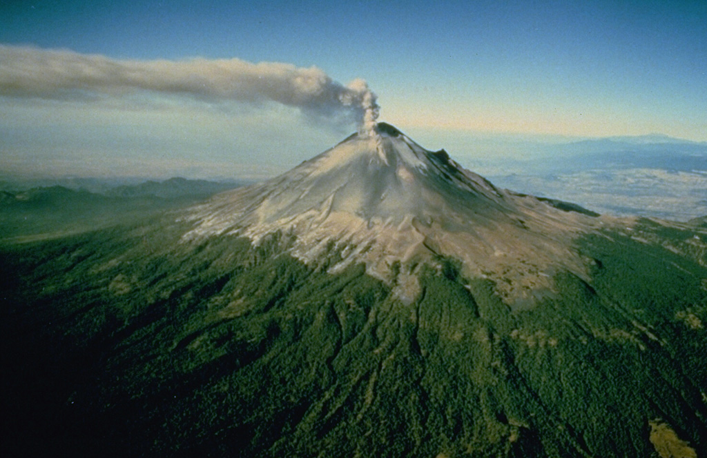 Popocatepetl Popocatepetl
Trans-Mexican Volcanic Arc
|
The Centro Nacional de Prevención de Desastres (CENAPRED) reported that eruptive activity continued at Popocatépetl during 9-15 April. The seismic network recorded 18-94 long-period events per day on most days, accompanied by steam-and-gas emissions. In addition, the seismic network also recorded daily low-amplitude tremor, characterized by harmonic and high-frequency signals, with periods lasting from 11 minutes to five hours and 11 minutes. A single volcano-tectonic earthquake was detected on 9 April. According to the Washington VAAC an ash plume was visible in webcam and satellite images on 10 April rising 6 km (20,000 ft) a.s.l. and drifting E. The Alert Level remained at Yellow, Phase Two (the middle level on a three-color scale) and the public was warned to stay 12 km away from the crater.
Sources: Centro Nacional de Prevencion de Desastres (CENAPRED), Washington Volcanic Ash Advisory Center (VAAC)
|
Reventador (Ecuador) | 9 April-15 April 2025 | Continuing ActivityCite this Report |
 Reventador Reventador
Northern Andean Volcanic Arc
|
The Instituto Geofísico-Escuela Politécnica Nacional (IG-EPN) reported that eruptive activity continued at Reventador during 9-15 April. Seismicity included 60-106 daily explosions, long-period earthquakes, harmonic tremor, and tremor associated with emissions. Multiple daily ash-and-gas plumes rose 200-2,200 m above the crater rim and drifted mainly NW, SW, and W. Webcams recorded multiple nightly instances of incandescent material descending the flanks as far as 1.1 km below the crater rim. During 8-9 April several pyroclastic flows were recorded, reaching more than 700 m below the crater on the SSW flanks. On the morning of 10 April a small lahar was recorded descending the S flank. That same day, a pyroclastic flow traveled down the SSW flank. Webcam images on 11 April showed another pyroclastic flow descending the SSW flank, with another on 12 April reaching 500 m below the crater on the SW flank. Several pyroclastic flows on the SW flank reached 1 km below the crater on 13 April. On 14 April two pyroclastic flows descended the SE flank as far as 800 m below the crater. Secretaría de Gestión de Riesgos maintained the Alert Level at Orange (the second highest level on a four-color scale).
Sources: Instituto Geofísico-Escuela Politécnica Nacional (IG-EPN), Secretaría de Gestión de Riesgos (SGR)
|
Sangay (Ecuador) | 9 April-15 April 2025 | Continuing ActivityCite this Report |
 Sangay Sangay
Northern Andean Volcanic Arc
|
The Instituto Geofísico-Escuela Politécnica Nacional (IG-EPN) reported that moderate levels of eruptive activity continued at Sangay during 9-15 April. The seismic network recorded 45-125 daily explosions. Weather clouds often obscured views, but daily gas-and-ash plumes were visible rising 300-2,100 m above the summit and drifting in different directions. Nighttime crater incandescence was often visible. During the night of 8 April several incandescent avalanches were detected 400 m below the crater rim. During the early morning of 11 April several incandescent eruptions were visible above the crater level. A webcam image showed incandescent ejecta on the SE drainage. Secretaría de Gestión de Riesgos (SGR) maintained the Alert Level at Yellow (the second highest level on a four-color scale).
Sources: Instituto Geofísico-Escuela Politécnica Nacional (IG-EPN), Secretaría de Gestión de Riesgos (SGR)
|
Santa Maria (Guatemala) | 9 April-15 April 2025 | Continuing ActivityCite this Report |
 Santa Maria Santa Maria
Central America Volcanic Arc
|
The Instituto Nacional de Sismología, Vulcanología, Meteorología e Hidrología (INSIVUMEH) reported ongoing eruptive activity at Santa Maria’s Santiaguito dome complex during 9-15 April with continuing lava extrusion at Caliente dome. Daily explosions, as many as seven per hour when reported, generated gas-and-ash plumes that rose as high as 1.2 km above the dome and possibly drifted as far as 40 km S, E, SE, and NE. Effusion of blocky lava and collapses of material produced block avalanches that mainly descended the S, SW, and W flanks. Collapsed material sometimes produced short pyroclastic flows that descended the flanks in all directions. Incandescence was visible at Caliente dome and upper part of the SW flank lava flow. On 9 April heavy rainfall generated lahars in the Tambor drainage (SSW) that carried blocks up to 1 m in diameter mixed with fine sediment, tree trunks, and branches. A sulfurous odor was also reported. Ashfall was reported from Nuevo Palmar (12 km SSW) and Pueblo Nuevo to San Felipe (15 km SSW) and Loma Linda (7 km W) during 11-12 April and in Las Marías (9.5 km S), Calaguaché (9 km S), and Belén (10 km S) during 12-13 April.
Source: Instituto Nacional de Sismologia, Vulcanologia, Meteorologia, e Hidrologia (INSIVUMEH)
|
Semeru (Indonesia) | 9 April-15 April 2025 | Continuing ActivityCite this Report |
 Semeru Semeru
Sunda Volcanic Arc
|
The Pusat Vulkanologi dan Mitigasi Bencana Geologi (PVMBG) reported that activity continued at Semeru during 9-15 April. Daily ash plumes rose 400-1,000 m above the summit and drifted SW, S, and NE; ash plumes were not visible on 13 April. White gas-and-steam emissions rose 100 m above the summit and drifted N, NE, and S on 10 April. The Alert Level remained at 2 (the second lowest level on a scale of 1-4). The public was warned to stay at least 5 km away from the summit in all directions, 13 km from the summit to the SE, 500 m from the banks of the Kobokan drainage as far as 17 km from the summit, and to avoid other drainages including the Bang, Kembar, and Sat, due to lahar, avalanche, and pyroclastic flow hazards.
Source: Pusat Vulkanologi dan Mitigasi Bencana Geologi (PVMBG, also known as CVGHM)
|
Sheveluch (Russia) | 9 April-15 April 2025 | Continuing ActivityCite this Report |
 Sheveluch Sheveluch
Eastern Kamchatka Volcanic Arc
|
The Kamchatkan Volcanic Eruption Response Team (KVERT) reported that lava extrusion may have continued at Sheveluch’s “300 years of RAS” dome on the SW flank of Old Sheveluch and at the Young Sheveluch dome during 3-10 April. Daily thermal anomalies over the domes were identified in satellite images. The Aviation Color Code remained at Orange (the second highest level on a four-color scale). Dates are based on UTC times; specific events are in local time where noted.
Source: Kamchatkan Volcanic Eruption Response Team (KVERT)
|
Stromboli (Italy) | 9 April-15 April 2025 | Continuing ActivityCite this Report |
 Stromboli Stromboli
Aeolian Volcanic Arc
|
The Sezione di Catania - Osservatorio Etneo (INGV) reported that eruptive activity continued at Stromboli during 7-13 April. Webcam images showed Strombolian activity at four vents in Area N within the upper part of the Sciara del Fuoco and from at least two vents in Area C-S (South-Central Crater) on the crater terrace. The vents in Area N continued to produce low-to-medium-intensity explosions at a rate of 5-15 events per hour, ejecting lapilli and bombs less than 150 m above the vents. Explosions at the vents in Area C-S ejected tephra above the vent at a rate of 1-7 events per hour. The Alert Level remained at Orange (the second highest level on a four-level scale).
Source: Sezione di Catania - Osservatorio Etneo (INGV)
|
Suwanosejima (Japan) | 9 April-15 April 2025 | Continuing ActivityCite this Report |
 Suwanosejima Suwanosejima
Ryukyu Volcanic Arc
|
The Japan Meteorological Agency (JMA) reported that eruptive activity at Suwanosejima's Ontake Crater continued during 7-14 April. Incandescence was observed nightly in webcam images. Eruptive activity generated emissions that rose 1 km above the crater rim. Ashfall was reported by the Suwanosejima Branch of the Toshima Village Office (3.5 km SSW). The Alert Level remained at 2 (the second level on a five-level scale) and the public was warned to stay at least 1.5 km away from the crater.
Source: Japan Meteorological Agency (JMA)
|
