Recovery efforts from the 14-15 January eruption of Hunga Tonga-Hunga Ha'apai continued in Tonga. According to a news article, the main undersea international fiber-optic communication cable that had been severed in multiple places due to the eruption had been repaired by 21 February, and internet connectivity was restored by 22 February. Repairs had begun on 3 February to rejoin 5-6 pieces and replace a 55 km section of the cable that was missing and likely buried in sediment. A domestic cable that was located closer to the volcano may take months to repair. Another news article noted that over 200 fishing boats had been destroyed by the tsunamis; dozens of new boats had been gifted by international donors.
Sources: Matangi Tonga Online, Matangi Tonga Online, Matangi Tonga Online, Associated Press
Surtseyan explosions with eruption plumes during 14-15 January 2022
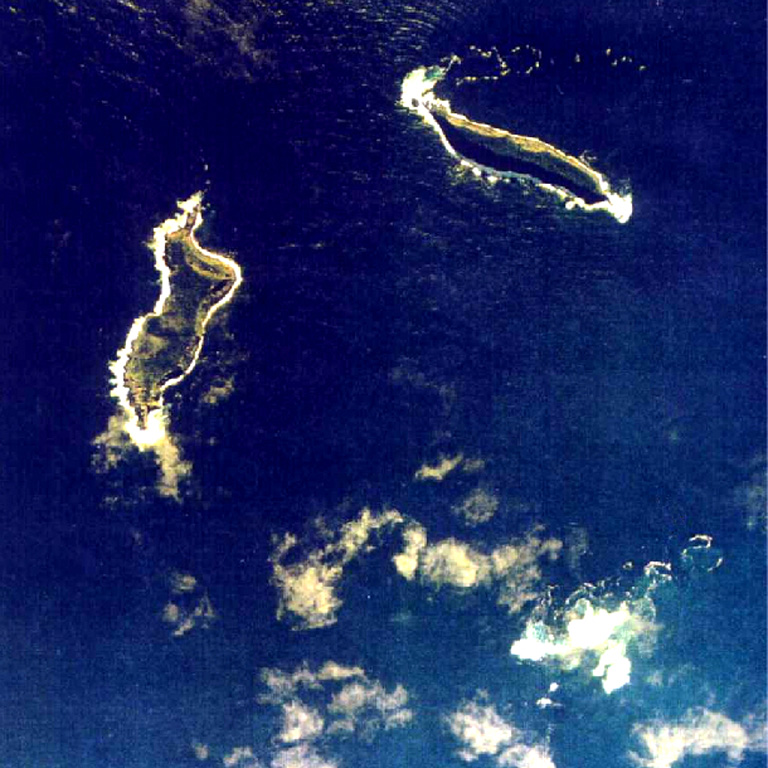
The Hunga Tonga-Hunga Ha’apai volcano includes the small islands of Hunga Tonga and Hunga Ha’apai along with shallow reefs along the caldera rim of a much larger submarine edifice in the western South Pacific Ocean (see figure 25; BGVN 47:02), west of the main inhabited islands in the Kingdom of Tonga. It is one of 12 confirmed submarine volcanoes along the Tofua Arc, a segment of the larger Tonga-Kermadec volcanic arc. The Tonga-Kermadec arc formed as a result of subduction of the Pacific Plate beneath the Indo-Australian Plate. The capital city of Tonga, Nuku’alofa, is located 65 km S on the island of Tongatapu. New Zealand lies 2,000 km S, and Australia is over 3,000 km SW.
The first recorded eruption at this site occurred in 1912, followed by an eruption in 1937, and then S of the islands in 1988. In 2009 a short eruption increased the land area at Hunga Ha’apai; around this time the two islands were each about 2 km long (BGVN 34:03). During December 2014 through January 2015 eruptive activity added land between the islands, creating the merged Hunga Tonga-Hunga Ha’apai island (BGVN 40:01). Major Surtseyan explosions and eruption plumes were detected beginning in late December 2021, which initially reshaped the central part of the combined island (BGVN 47:02) before stronger activity on 14 January 2022 removed most of the 2014-2015 material. The next day, 15 January, an even larger eruption generated a plume that reached at least 20 km altitude, caused a tsunami across the Pacific Ocean, and triggered shock waves through the atmosphere; only small remnant of the islands remained visible above the ocean surface. This report will update details of the large 14-15 January 2022 events using information primarily from the Tonga Geological Services (TGS), Tongan and New Zealand news outlets, the Wellington and Darwin Volcanic Ash Advisory Centers (VAAC), and various satellite data.
Activity during 1-13 January 2022. According to observations of satellite images, little eruptive activity was detected during 1-2 January. On 2 January a Sentinel-2 natural color image showed green-yellow discolored water in the area west of the volcano, accompanied by white gas-and-steam emissions drifting NE on the SW end of the westernmost island (figure 44). Pumice rafts roughly 10 m wide were also visible in Sentinel-2 satellite imagery, drifting about 100 km W of the volcano on 2 January (see figure 41; BGVN 47:02). The surface area of the island had grown from approximately 2 km2 on 10 December 2021 to 3.6 km2 on 2 January 2022. The vent was estimated to be at 90 m elevation and the base of the active cone had grown from 500 to 1,700 m wide.
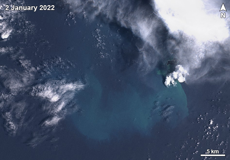 |
Figure 44. A Sentinel-2 satellite image showing green-yellow discolored water surrounding the area to the W of Hunga Tonga-Hunga Ha’apai captured on 2 January 2022. Some white gas-and-steam emissions are visible rising from the SW end of the island. Image uses “Natural color” rendering (bands 4, 3, 2). Courtesy of Sentinel Hub Playground. |
A small ash plume was detected during 2220-2230 on 3 January that rose to 6-7 km altitude and drifted 5-10 km NE, according to TGS (figure 45). At 2230 the plume decreased in altitude to 5 km. During 3-4 January a cyclone passed through the area, obscuring views of the volcano. A minor ash plume was again detected between 0000 and 0010 on 5 January, which rose to 8 km altitude and drifted 15 km NE; by 0010 the plume had drifted 18 km ENE. Some pumice had washed up on the northwestern beaches of Tongatapu Island on 5 January (see figure 42; BGVN 47:02) and a sulfurous odor was reported on the Nuku’alofa waterfront on 6 January.
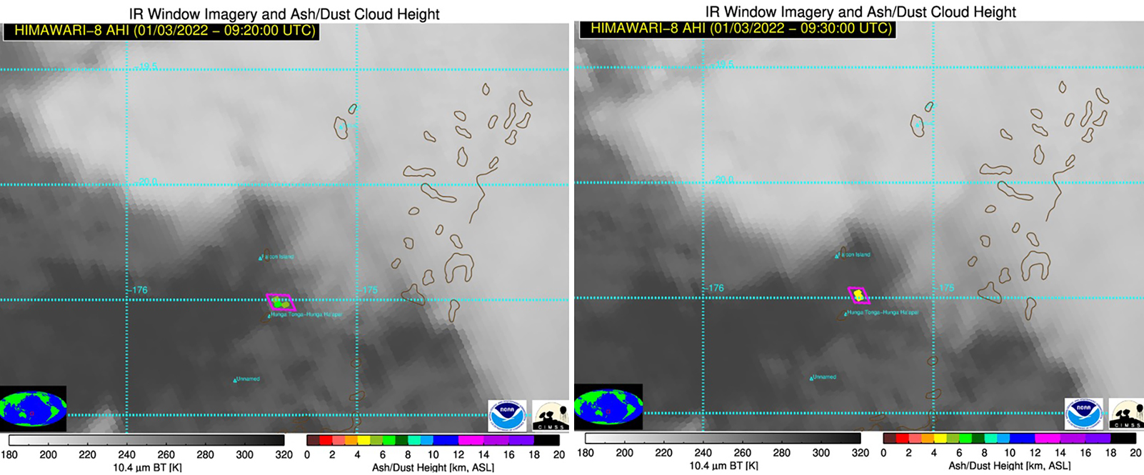 |
Figure 45. HIMAWARI-8 AHI satellite images captured a small ash plume rising 5-10 km NE from Hunga Tonga-Hunga Ha’apai (purple box) at 2220 (left) and 2230 (right) on 3 January 2022. At 2220 the plume rose to 6-7 km altitude and by 2230, it had decreased to 5 km, based on the color scale on the bottom right of each image. Courtesy of Tonga Geological Services. |
Activity during 14 January 2022. A sub-aerial eruption that began at 0420 on 14 January generated a mushroom-shaped eruption plume consisting of gas-and-steam and ash which was 5 km wide at the base and rose to the stratosphere, 18-20 km altitude, according to TGS (figure 46). The plume expanded radially to 240-260 km diameter and extended over Tongatapu (70 km S), ‘Eua (106 km SSE), Ha’apai (130 km NE), and Vava’u (270 km NNE). Geologists on a boat observed Surtseyan pulses ejecting dark, dense material into the air and pyroclastic flows expanding over the ocean around 1700-1830 (figure 47). The activity removed approximately the middle third of the island that had been enlarged over the previous weeks, according to analysis of a Planet Labs satellite image acquired at 1525 on 15 January (figure 48).
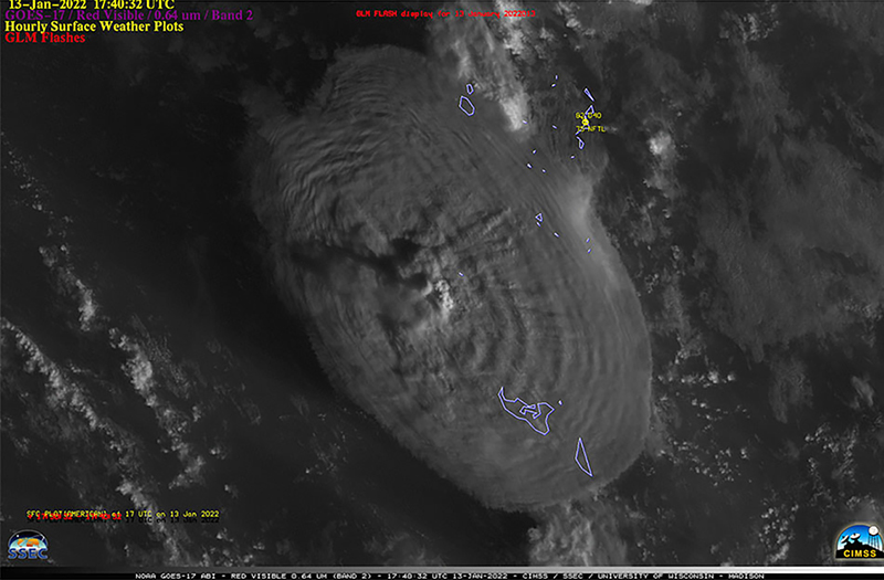 |
Figure 46. A massive eruption plume rising above Hunga Tonga-Hunga Ha’apai was captured by the GOES-17 satellite (NOAA) at 0640 on 14 January 2022. The plume rose above 16 km altitude and expanded radially at the top to 240-260 km in diameter. Tongan islands are outlined in blue. Courtesy of CIMSS and SSEC. |
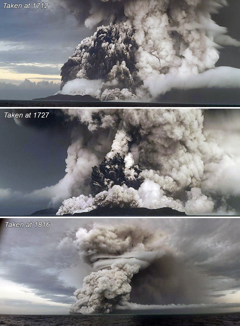 |
Figure 47. Successive photos of the explosion at Hunga Tonga-Hunga Ha’apai taken at 1712 (top), 1727 (middle), and 1816 (bottom) on 14 January 2022. The view at 1712 is towards the NE with the volcano in the foreground. The photo at 1727 looks E with Hunga Ha’apai in the foreground and Hunga Tonga on the far right. In the 1816 image the view is to the N with Hunga Ha’apai to the left of the plume. The plume measures 5 km wide at the base and rises to 18-20 km altitude in each of these photos. Courtesy of Tonga Geological Services. |
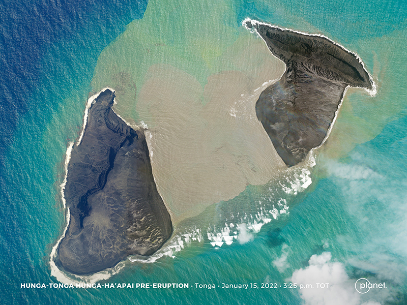 |
Figure 48. The center section of Hunga Tonga-Hunga Ha’apai became submerged as a result of the large explosion on 14 January 2022. It is surrounded by green-yellow discolored water and gray-brown pumice rafts. Image courtesy of Tanya Harrison, Planet Labs. |
A national tsunami warning was issued at 1112 due to abnormal swirling water off the coast of Nuku’alofa, according to a Matangitonga news article. The Tonga Meteorological Services (TMS) also issued tsunami warnings for areas including ‘otu Mu’omu’a in Ha’apai (Nomuka, Mango, Fonoifua), ‘Atataa, ‘Eueiki, and Tongatapu mo ‘Eua. Fluctuating tsunami waves were recorded off the coast of Tongatapu throughout the day; waves reached 200 m inland and rose as high as 15 m in elevation on the Good Samaritan Beach, according to TGS. The highest tsunami wave was recorded around 1800, measuring 30 cm, according to the Nuku’alofa tidal gauge.
The eruption on 14 January continued for more than 12 hours, with the plume reaching 20 km altitude, based on data from HIMAWARI-8 AHI satellite imagery captured between 1410 and 2330. Ashfall was reported on the Mango and Fonoi (75 km ENE) islands of Ha’apai. The eruption plume also contained an estimated sulfur dioxide mass of 0.05 Tg (50 kilotons), based on satellite data. As a result, the smell of sulfur was reported over Tongatapu, Ha’apai, and ‘Eua. Ashfall was reported on many islands, including Fonoi and Mango. All domestic flights in Tonga were canceled on 15 January. By 2230 the altitude of the plume had decreased to 18 km. The Global Lightning Detection Network (GLD360) ground-based network detected 191,309 lightning events from 0334 on 14 January through 0134 on 15 January, or up to 30,000 events per hour.
Activity during 15 January 2022. The eruption was intermittent during 0043 through 0604, according to the Wellington VAAC; plumes rose to 14 km altitude. The Nuku’alofa tidal gauge recorded waves less than 10 cm high through 1000 on 15 January, causing the National Tsunami Warning Centre to cancel the tsunami marine warning for Tongatapu, Ha’apai, and southern Tonga. Based on observations from satellite images, an ash plume rising to 14 km altitude was detected at 0720 on 15 January that drifted downwind to the E from the volcano due to an eruption that lasted 10-15 minutes.
A larger submarine eruption began at 1700 on 15 January from vents just below the surface of the ocean, generating an eruption plume of gas, steam, and some ash. A report from the Wellington VAAC stated that the plume had risen to 15.2 km altitude by 1918; the top of the plume was at least 600 km in diameter by 1903 as seen in satellite images (figure 49). According to news reports and social media posts, residents in Nuku’alofa heard multiple loud booms and saw a large expanding eruption plume that eventually covered all the Tongan islands. The eruptive activity lasted eight minutes.
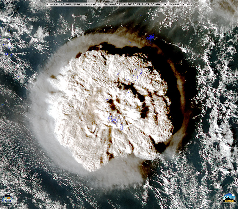 |
Figure 49. HIMAWARI-8 satellite image showing the significant eruption plume that rose from Hunga Tonga Hunga Ha’apai taken at 1800 (local time) on 15 January 2022. The top of the plume measured at least 600 km in diameter and rose to at least 20 km altitude, possibly higher. Tongan islands are outlined in blue. Courtesy of CIMSS. |
Ashfall eventually measuring several centimeters thick started around 1800 on 15 January and lasted about 10 hours (figure 50), which also affected water tanks and some residents reported having difficulty from breathing the ash in the air. The eruption caused a communications black out across the country, which included damaging the underwater fiber-optic cable providing access to the internet and damage to satellite terminals due to being covered in ash.
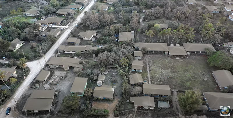 |
Figure 50. Drone image of the tsunami aftermath from the Hunga Tonga-Hunga Ha’apai eruption taken on 16 January 2022. Image shows ashfall in Nuku’alofa. Courtesy of Tonga Geological Services. |
During 1719-2300 on 15 January there were almost 400,000 lightning events recorded in the plume by the GLD360 network, with 200,000 of those occurring during 1800-1900. The plume continued to rise to at least 20 km altitude, though other satellite datasets suggested that some of it may have risen as high as 30 km. At 0343 on 16 January the plume was at 19.2 km altitude. Based on volcanic ash advisories issued by the Wellington VAAC and then by the Darwin VAAC, the horizontal extent of the plume grew from 18,000 km2 at 1739 on the 15th to 12 million km2 by 1300 on 19 January. The plume narrowed and lengthened along an E-W axis, moving W over Australia. According to data from the TROPOMI instrument on the Sentinel-5P satellite, a sulfur dioxide plume was detected with a mass of roughly 50 kilotons on 14 January, 420 kilotons that drifted W on 16 January, and 400 kilotons that continued to drift W on 17 January (figure 51).
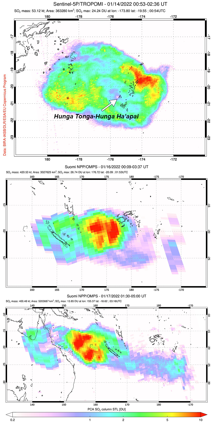 |
Figure 51. A large sulfur dioxide plume was released from Hunga Tonga-Hunga Ha’apai on 14 January 2022 (top) that measured roughly 50 kilotons. Significant plumes with a mass of roughly 400-420 kilotons continued to be visible on 16 January (middle) and 17 January (bottom) drifted W. Courtesy of NASA Global Sulfur Dioxide Monitoring Page via Simon Carn. |
The explosions produced multiple pressure (shock) waves that rippled through surrounding weather clouds at a rate of 300 m/s, though the pressure wave from the largest explosion propagated across the planet. The sonic boom from this wave was heard at great distances, including within about two hours in New Zealand (2,300 km SW), Samoa, Fiji (500 km NW), Vanuatu, Cook Islands, and Alaska (9,370 km NE km). The pressure wave was also recorded by infrasound and weather instruments worldwide as it circled the Earth, with instruments detecting it again when it arrived from the opposite direction.
Warnings were issued for the N and E coasts of New Zealand’s North Island and the Chatham Islands; multiple boats were destroyed overnight in Tutukaka Marina in Far North (figure 52). According to an RNZ article, more than 120 people had been evacuated from the Far North between 2300 and 0000. Tsunami waves reaching 1.2 m high hit Nuku’alofa during the evening, breaching the shoreline and flooding coastal roads and properties. At Mango Island (75 km ENE), the tsunami waves reached 500 m inland and rose as high as 12 m high, destroying buildings and trees (figure 53). According to the Tongan Navy, tsunami waves that hit Mango Island reached 5-10 m high. According to an official update from the Tongan government on 20 January, tsunami waves reached up to 15 m high, which affected the W coasts of Tongatapu, 'Eua, and Ha'apai Islands and the water depth in the village of Kanokupolu was 1.5 m.
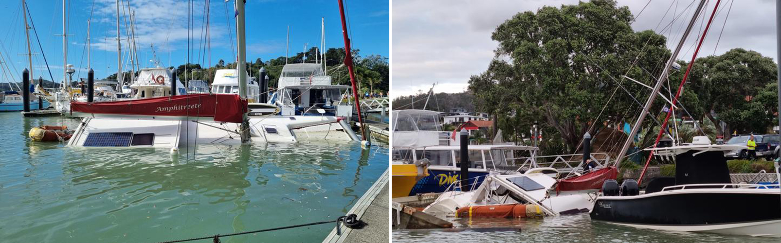 |
Figure 52. Photos of boats that were damaged by strong tsunami waves during the night of 15 January 2022 as a result of the Hunga Tonga-Hunga Ha’apai eruption and possibly Cyclone Cody at Tutukaka Marina in Far North. Photo by Sam Olley. Courtesy of Radio New Zealand. |
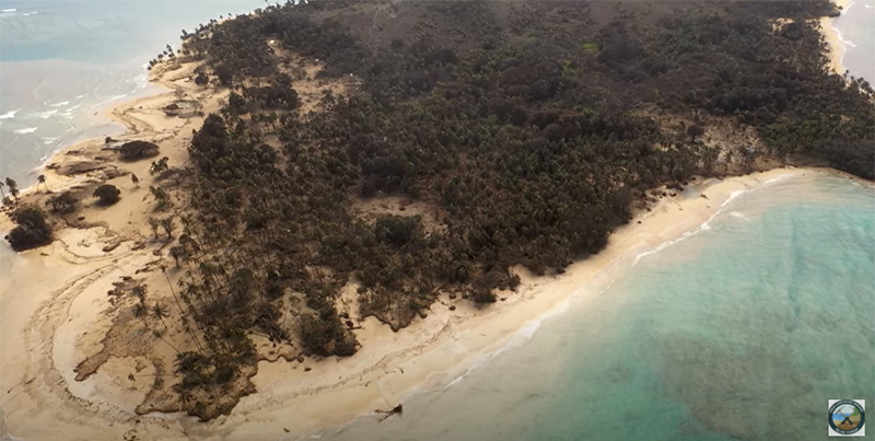 |
Figure 53. Video footage of Mango Island (75 km NE) showing the damage caused by the tsunami waves generated by Hunga Tonga-Hunga Ha’apai from the eruption on 15 January 2022 coupled with an acoustic wave that permeated the atmosphere. The resulting wave measured 12 m high and moved as far as 500 m inland. Traces of the waves can be observed based on the dark brown rings surrounding the coast on the sand. Ashfall lasting 10 hours was also reported after 1800 on the 15th. Footage was captured on 20 January 2022. Video captured by Nikolasi Heni. Courtesy of Tonga Geological Services. |
In Japan, around 230,000 people were advised to evacuate across eight prefectures due to the tsunami risk. The resulting waves were recorded in the Kominato district of Amami-Oshima Island in Kagoshima Prefecture at 2355. The waves reached 80 cm in Japan, disrupting train services, flights, and damaging harbors and boats. In Anchorage, Alaska, the US National Weather Service reported maximum waves heights of 20-100 cm on Alaskan coastlines and along the British Columbia coast, waves were 16-29 cm. By the morning of 16 January, the tsunami warning had been extended to the W coast of South Island. Reports indicated that the villages of Sopu, Kolomotua, Kolofo'ou, Ma'ufanga, Patangata were also affected by the tsunami, especially areas near Vuna Road.
Activity during 16-31 January 2022. No new eruptive events were detected after the large explosive eruption on 15 January. A satellite image taken on 18 January showed that most of the previously combined island had been destroyed, leaving only a small part of the NE island of Hunga Tonga (200 m long) and the SW island of Hunga Ha’apai (700 m long) visible above the ocean surface (figure 54). Pumice rafts were visible to the SE of Hunga Ha’apai. The Aviation Color Code was lowered to Green on 19 January. According to the Darwin VAAC, the plume continued to drift W at altitudes between 12.8 and 19.2 km during 19-22 January; the ash was diffuse and difficult to distinguish from meteorological clouds, though the sulfur dioxide signal was stronger. The leading edge of the plume reached the E coast of Africa on 22 January, but by 2150 (local time) the Darwin VAAC noted that ash was no longer detectable.
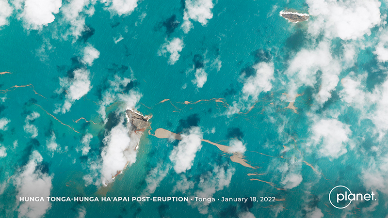 |
Figure 54. Following the major eruption on 15 January 2022, this image taken on 18 January shows that most of the previous combined island had been destroyed, leaving only small remnants of the NE island of Hunga Tonga (200 m long) and the SW island of Hunga Ha’apai (700 m long) visible above the ocean surface. A few days after the eruptive activity, pumice rafts were still visible in the area. Images courtesy of Tanya Harrison, Planet Labs. |
The Tongan Ministry of Foreign Affairs and Trade confirmed three deaths and multiple people injured following the explosion and tsunami on 15 January. Aerial surveillance images showed that buildings and villages had washed away or been badly damaged, roofs were covered with ash, trees were uprooted, vegetation was brown and damaged, and modified coastlines contained sediment-laden waters. All the houses on Mango Island were destroyed due to the tsunami waves; a few temporary tarpaulin shelters were still visible. Only two houses remained on Fonoifua, and extensive damage was also reported on Nomuka Island (figure 55). Evacuations began on 19 January, which included people on the islands of Mango, Atata, and Fonoifua; about 150 people were evacuated to other islands. About 89 people remained in evacuation shelters on the island of ‘Eua. According to the Tongan government, parts of the W side of Tongatapu, including Kanokupolu, were evacuated after dozens of houses were damaged (figure 55), and in the central district many houses were damaged in Kolomotu'a and on the island of 'Eua. Numerous buildings were reported gone on Atata Island. Roughly 62 survivors were evacuated from Mango Island to Tongatapu on 22 January via a Navy patrol boat. According to a news article from Radio New Zealand, two deaths were reported from a beach in Peru (over 10,000 km) due to high tsunami waves.
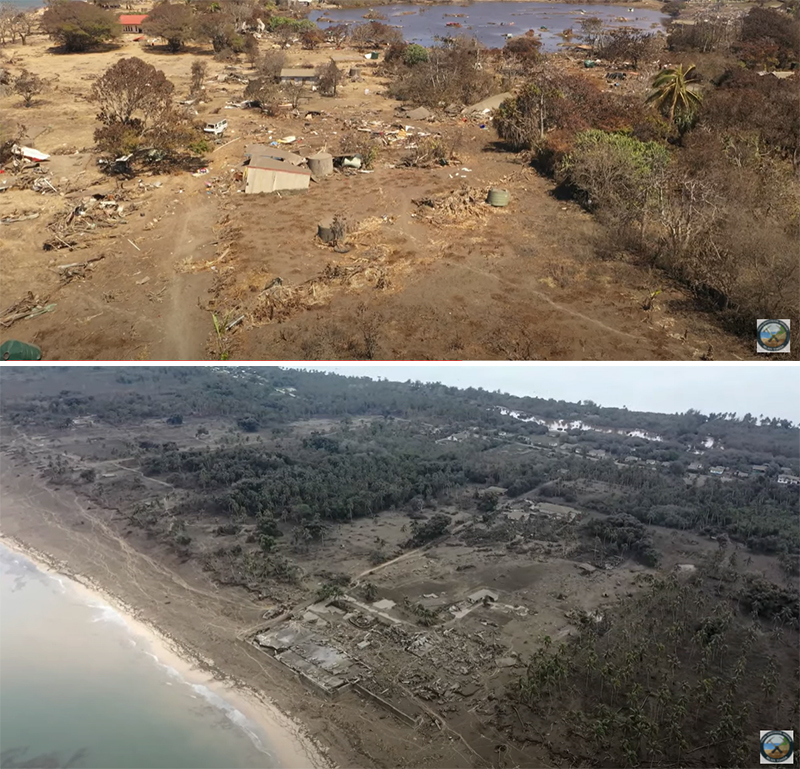 |
Figure 55. Drone images of Nomuka Island (top) and Kanokupolu Village (bottom) showing the damage caused by the Hunga Tonga-Hunga Ha’apai eruption taken on 16 January 2022. Image on the bottom shows the remnants of the Vakaloa Resort. Footage of Nomuka Island was recorded by Nikolasi Heni. Courtesy of Tonga Geological Services. |
According to a media release from the Government of Tonga on 21 January, all the islands were affected by ashfall and tsunami waves. A relief flight from New Zealand brought telecommunication equipment and a repair vessel was sent to repair the damaged seafloor fiber-optic cable; domestic flights remained suspended. Dozens of Mw 4.5-5 earthquakes were detected in the vicinity of the volcano after the eruption, at least through 24 January, though the type of earthquake signal was unknown.
Information Contacts: Tonga Geological Services, 51 Vaha'akolo Road, Nuku’alofa, Tonga (URL: https://www.facebook.com/tongageologicalservice); Matangi Tonga Online, PO Box 958, Nuku‘alofa, Tonga (URL: https://matangitonga.to/); RNZ (Radio New Zealand) Pacific, PO Box 123, Wellington 6140, New Zealand (URL: https://www.rnz.co.nz); Darwin Volcanic Ash Advisory Centre (VAAC), Bureau of Meteorology, Northern Territory Regional Office, PO Box 40050, Casuarina, NT 0811, Australia (URL: http://www.bom.gov.au/info/vaac/); Wellington Volcanic Ash Advisory Centre (VAAC), Meteorological Service of New Zealand Ltd (MetService), PO Box 722, Wellington, New Zealand (URL: http://www.metservice.com/vaac/, http://www.ssd.noaa.gov/VAAC/OTH/NZ/messages.html); Planet Labs, Inc. (URL: https://www.planet.com/); NASA Global Sulfur Dioxide Monitoring Page, Atmospheric Chemistry and Dynamics Laboratory, NASA Goddard Space Flight Center (NASA/GSFC), 8800 Greenbelt Road, Goddard, MD 20771, USA (URL: https://so2.gsfc.nasa.gov/); Cooperative Institute for Meteorological Satellite Studies, University of Wisconsin-Madison, Space Science and Engineering Center, 1225 West Dayton Street, Madison, WI 53706, USA (URL: http://tropic.ssec.wisc.edu/); Sentinel Hub Playground (URL: https://www.sentinel-hub.com/explore/sentinel-playground); 1 News, New Zealand (URL: https://www.1news.co.nz/); Tanya Harrison, Planet Labs, Inc. (URL: https://twitter.com/tanyaofmars); Chris Vagasky, National Lightning Safety Council (URL: https://twitter.com/COweatherman); Simon Carn, Geological and Mining Engineering and Sciences, Michigan Technological University, 1400 Townsend Drive, Houghton, MI 49931, USA (URL: http://www.volcarno.com/, Twitter: @simoncarn).
2022: January
| February
2021: December
2015: January
2014: December
2009: March
Recovery efforts from the 14-15 January eruption of Hunga Tonga-Hunga Ha'apai continued in Tonga. According to a news article, the main undersea international fiber-optic communication cable that had been severed in multiple places due to the eruption had been repaired by 21 February, and internet connectivity was restored by 22 February. Repairs had begun on 3 February to rejoin 5-6 pieces and replace a 55 km section of the cable that was missing and likely buried in sediment. A domestic cable that was located closer to the volcano may take months to repair. Another news article noted that over 200 fishing boats had been destroyed by the tsunamis; dozens of new boats had been gifted by international donors.
Sources: Matangi Tonga Online; Matangi Tonga Online; Matangi Tonga Online; Associated Press
On 4 February the Tonga Geological Services (TGS) posted drone footage of the Good Samaritan Beach, located on the NE side of Tongatapu, showing that tsunamis from the 15 January Hunga Tonga-Hunga Ha'apai eruption reached areas at 15 m elevation, 200 m inland. A 6 February post provided details of what happened when tsunamis reached Mango Island (75 km ENE), stating that waves 12 m high went over the church tower, reached 500 m inland, and pushed buildings and structures against the inland wall of trees. Residents fled to an area that was 30 m elevation, 700 m from the coast, and stayed there all night as ash fell. TGS noted that clean-up efforts were continuing on the islands and communications were slowly being restored.
Source: Tonga Geological Services, Government of Tonga
No additional eruptive events were detected at Hunga Tonga-Hunga Ha'apai after the large and explosive eruption on 15 January. The gas, steam, and ash plume produced during that eruption rose into the stratosphere and drifted W. Based on volcanic ash advisories issued by the Wellington VAAC and then by the Darwin VAAC, the horizontal extent of the plume grew from 18,000 square kilometers at 1739 on 15 January to 12 million square kilometers by 1300 on 19 January. The plume narrowed and lengthened along an E-W axis, moving W over Australia. The Aviation Color Code was lowered to Green on 19 January. According to the Darwin VAAC the plume continued to drift W at altitudes between 12.8 and 19.2 km (42,000 and 63,000 ft) a.s.l. during 19-22 January; the ash was diffuse and difficult to distinguish from meteorological clouds, though the sulfur dioxide signal was stronger. By 22 January the leading-edge of the plume had reached the E coast of Africa. By 2150 the Darwin VAAC noted that ash was no longer detectable.
Tsunami waves generated by the 15 January eruption caused an oil spill near at the La Pampilla refinery along Peru’s coast, affecting a 38-km-stretch of beach from Ventanilla to Peralvillo Beach in Chancay, according to Peru’s Agency for Environmental Assessment and Enforcement (OEFA). An estimated 6,000 barrels of oil were spilled, significantly impacting an estimated 180 hectares of beach, almost 715 hectares of ocean, and local fisherman.
In a media release on 21 January, the Government of Tonga reported that ashfall and tsunami had damaged all islands. International humanitarian aid had reached the islands the day before, five days after the eruption ceased. Inter-island and international communication remained challenging though was partially restored; a relief flight from New Zealand brought telecommunication equipment and a repair vessel was en-route to the damaged seafloor fiber-optic cable. Floating debris, likely including pumice, hindered sea transportation. Domestic flights remained suspended, though international flights carrying relief supplies were able to land and aerial surveys of damage were conducted. According to a social media post from 23 January residents swept ash off of a Salote Pilolevu Airport runway in Ha’apai. News reports shared stories of survivors and showed images of damage around the islands.
Dozens of earthquakes, M 4.5-5, were centered in the vicinity of the volcano after the eruption, at least through 24 January. The type of earthquake signal was unknown, though they likely represented post-eruption movement along existing faults and not magma movement.
Sources: Josephine Latu-Sanft; Brisbane Times; Consulate of the Kingdom of Tonga; Judith Hubbard; Matangi Tonga Online; Wellington Volcanic Ash Advisory Center (VAAC); Darwin Volcanic Ash Advisory Centre (VAAC); Advanced geospatial Data Management Platform (ADAM); National Public Radio (NPR); Dov Bensimon, Montréal Volcanic Ash Advisory Centre (VAAC); Simon Carn; Agency for Environmental Assessment and Enforcement (OEFA), Peru; Andina Agencia Peruana de Noticias; US Geological Survey Earthquake Hazards Program
Large eruptions at Hunga Tonga-Hunga Ha'apai on both 14 and 15 January produced plumes that reached the stratosphere and caused significant regional effects. Activity on the 14th apparently removed approximately the middle third of the island that had been expanded over the previous few weeks, revealed by a Planet Lab image acquired at 1525 on 15 January. About two hours after that image was taken an even stronger eruption produced a stratospheric plume seen in satellite images, sent pressure waves across the atmosphere, and caused tsunami that traversed the Pacific. Following these explosions, a Sentinel image acquired on 17 January showed that most of the previous combined island had been destroyed, leaving only small parts of the NE island of Hunga Tonga (200 m long) and the SW island of Hunga Ha'apai (700 m long) above the ocean surface.
A sub-aerial eruption that began at 0420 on 14 January produced mushroom-shaped ash, steam, and gas plumes that rose as high as 20 km (65,600 ft) a.s.l., into the stratosphere, and expanded radially at the top of the plume to 240 km in diameter, according to the Tonga Geological Services (TGS). Geologists observing from a boat around 1700-1830 in the afternoon noted that the plume was about 5 km wide at its base, with Surtseyan pulses ejecting dark dense material into the air, and pyroclastic flows expanding over the ocean. The eruption plume drifted over the island groups of Tongatapu, ‘Eua, Ha’apai, and Vava’u, carrying an estimated sulfur dioxide mass of 0.05 Tg (50,000 tonnes) based on satellite data. Sulfur odors were reported in Tongatapu (70 km S), near the capital on Motutapu Island, and on ‘Eua (106 km SSE). Ashfall was reported on many islands, including Fonoi and Mango (75 km ENE). The Tonga Meteorological Services (TMS) issued tsunami warnings for areas including ‘otu Mu’omu’a in Ha’apai (Nomuka, Mango, Fonoifua), ‘Atataa, ‘Eueiki, and Tongatapu mo ‘Eua. At 2000 on 14 January a tsunami with a height of 20 cm was recorded by the Nuku’olofa tide gauge. TMS warned residents to stay away from low-lying coastal areas, beaches, and harbors. The Wellington VAAC noted that the eruption was intermittent during 0043-0604 on 15 January; plumes rose to altitudes of 14 km (45,900 ft) a.s.l. The Global Lightning Detection Network (GLD360) ground-based network detected 191,309 lightning events during a 21-hour period (0334 on 14 January-0134 on 15 January), or up to 30,000 events per hour; for comparison, during 22-28 December 2018 the partial collapse eruption of Krakatau generated 337,000 events. TGS noted that at 0720 on 15 January an eruption lasting 10-15 minutes sent an ash plume to 14 km (45,900 ft) a.s.l. that drifted E.
A larger, submarine eruption began at 1700 on 15 January. According to news reports and social media posts, residents in Nuku'alofa (65 km S) heard multiple loud booms and saw a large expanding eruption plume that eventually covered all of the Tongan islands. According to the Wellington VAAC the plume had risen to 15.2 km (50,000 ft) a.s.l. by 1819; the top of the plume as seen in satellite images was at least 600 km in diameter by 1903. During 1719-2300 there were almost 400,000 lightning events recorded in the plume by the GLD360 network, with 200,000 of those during 1800-1900. By 0343 on 16 January the plume had risen to 19.2 km (63,000 ft) a.s.l. Analysis of other satellite datasets suggested that the plume may have risen to 30 km (98,400) a.s.l. The sulfur dioxide mass of the plume was 0.4 Tg (400,000 tonnes) derived from satellite-based estimates; the cloud drifted W consistent with stratospheric winds. Significant ashfall was reported on populated islands of Tonga, 70-100 km E. News articles noted that some residents had difficulty breathing from the ash in the air.
Most domestic and international communications on the islands were severed due to a break in an underwater cable, and ashfall has delayed both damage assessment and relief assistance. An update on 18 January from the Government of Tonga provided details about the eruption and its effects, noting that tsunami warnings issued after the eruption began had triggered evacuations. Tsunami waves 2-15 m high, based on a news article and the official report, arrived on the W coasts of the Tongatapu, ‘Eua, and Ha’apai islands, and three people in Tonga were confirmed to have died as a result, with many others injured. Extensive damage was reported on Mango, Fonoifua, and Nomuka islands, and on the W part of Tongatapu. Aerial surveillance by the New Zealand Defence Force’s showed brown, damaged vegetation and landscapes, debris, and modified coastlines with sediment-laden waters. The Government of Tonga also noted that communications to the outer islands were accomplished with a patrol boat on 17 January, and limited communication with residents of Vava’u and Ha’apai was possible the next day. Evacuation efforts were underway for some remote islands. Ashfall contaminated fresh water supplies, hindered sea transportation and harbor access, and caused flights to be cancelled. According to a news report the small island of Atata, near Nuku'alofa, had been completely submerged. Tsunami warnings were also issued in several other countries surrounding the Pacific Ocean. Several news sources reported flooding and damage caused by the tsunamis at locations as far away as Peru (over 10,000 km), where it caused two deaths. Warnings were issued for the N and E coasts of New Zealand’s North Island and the Chatham Islands; multiple boats were destroyed. Thousands in Japan evacuated after tsunami warnings, and the waves there reached 80 cm, disrupting train services, flights, and damaging harbors and boats. In Anchorage, Alaska, the US National Weather Service reported maximum waves heights of 20-100 cm on Alaskan coastlines, and along the British Columbia coast waves were 16-29 cm on 15 January.
The explosions produced multiple pressure (shock) waves that rippled through surrounding weather clouds, though the pressure wave from the largest explosion propagated across the planet. The sonic boom from this wave was heard at great distances, including in Fiji (about 500 km NW), within about two hours in New Zealand (1,600-2,000 km), and within about nine hours in Alaska, USA (9,370 km NE). The pressure wave was also recorded by infrasound and weather instruments worldwide as it circled the Earth, with instruments picking up the wave a second time as it arrived from the opposite direction. Very small perturbances in the ocean waves recorded in the Caribbean, which some referred to as meteotsunamis, were likely generated by atmospheric disturbances from the pressure waves after they passed over South America.
Sources: Wellington Volcanic Ash Advisory Center (VAAC); Tonga Geological Services, Government of Tonga; Tonga Meteorological Services, Government of Tonga; Planet Labs; Ghassan Taha, NASA; Simon Carn; Chris Vagasky, Vaisala; Robin Lacassin; 9 News Australia; Gerard Fryer, Affiliate Researcher at University of Hawaii at Manoa; National Weather Service Alaska Region; Consulate of the Kingdom of Tonga; National Weather Service, Anchorage; 1 News; 1 News; Dov Bensimon, Montréal Volcanic Ash Advisory Centre (VAAC); New Zealand Defence Force (NZDF); Stuff; Fijivillage; Andrew Tupper, Natural Hazards Consulting; Radio New Zealand
The eruption at Hunga Tonga-Hunga Ha'apai continued intermittently during 29 December 2021 to 4 January 2022, though by 3 January activity had significantly decreased. Several surges of Surtseyan activity, with some periods lasting as long as 30 minutes, occurred during 28-29 December; gas, steam, and ash plumes rose at least to 12.2 km (40,000 ft) a.s.l. and drifted N, though the maximum altitude of the ash-rich portion of the plume was lower. Ashfall was local to areas around the island. Discolored water and rafts of pumice were visible in areas around the island on 30 December, and had been observed since the beginning of the eruption. Steam-and-gas plumes were visible throughout the day, interspersed with occasional tephra ejections. The plumes rose as high as 12 km (39,400 ft) a.s.l. and drifted NNE. During the morning of 31 December intermittent plumes of ash, steam, and gas rose to 3 km (10,000 ft) a.s.l. according to the Wellington VAAC, though the steam-and-gas portion of the plume rose as high as 18 km (59,000 ft) a.s.l. as stated by the Tonga Meteorological Services. The Met Services also noted that ash was no longer visible in the emissions starting around noon.
Steam-and-gas plumes were occasional visible in satellite data during 1-2 January. A small ash plume rose 6-7 km (19,700-23,000 ft) a.s.l. during 2220-2230 on 3 January and drifted 10 m NE, dropping in altitude along the way. A cyclone that passed through the area during 3-4 January obscured views of the volcano.
Sources: Wellington Volcanic Ash Advisory Center (VAAC); Tonga Geological Services, Government of Tonga; Tonga Meteorological Services, Government of Tonga
The eruption at Hunga Tonga-Hunga Ha'apai that began on 20 December continued through 28 December. According to the Wellington VAAC continuous gas-and-steam plumes with diffuse ash rose 6.1-12.2 km (20,000-40,000 ft) a.s.l. and drifted NE and NNE during 22-23 December, based on pilot observations, satellite images, information from the Tonga Meteorological Office, and weather models. On 22 December Tonga Navy crew sailing near the island recorded Surtseyan explosions ejecting tephra 350 m high. The video confirmed that the vent was in the same area as the 2014 activity. According to a news article plumes of sulfur dioxide spread NNE over the Ha'apai, Vava'u, and Niuatoutapu island groups with the highest concentrations affecting the ‘Otumu‘omu‘a islands on 23 December.
Plumes became intermittent by 24 December rising to 10.4 km (34,000 ft) a.s.l. and occasionally as high as 12.2 km. Tonga Geological Services warned the public to stay outside of a 5 km radius of the vents. According to Tonga’s Lead Geologist, satellite images from 25 December showed that the island had grown 300-600 m on the E side, and ash was falling within a 10 km radius. During 25-28 December the gas-and-steam plume rose 9.1-12.2 km (30,000-40,000 ft) a.s.l. and drifted N and NE; the lower part of the plume contained ash and rose as high as 3 km (10,000 ft) a.s.l. Ashfall was confined to the vicinity of the volcano. Tonga Geological Services reported that during 27-28 December clouds of gas and steam drifted E across the ‘Otu Mu’omu’a Islands of Ha’apai at altitudes of 1-18 km (3,300-59,000 ft) a.s.l.; they warned residents to protect water reservoirs because rain may be acidic or contain traces of ash, though the plumes were predominantly drifting at high levels. One flight to Tonga was canceled on 28 December, for the second time since the eruption started.
Sources: Wellington Volcanic Ash Advisory Center (VAAC); Tonga Meteorological Services, Government of Tonga; Tonga Geological Services, Government of Tonga; Kaniva Tonga; Kaniva Tonga; Matangi Tonga Online; Matangi Tonga Online; Matangi Tonga Online; Matangi Tonga Online; Matangi Tonga Online; Matangi Tonga Online
According to a news article, Tonga’s head geologist reported that an eruption at Hunga Tonga-Hunga Ha'apai began at 0935 on 20 December. The eruption produced a steam-rich gas-and-ash plume that initially rose to 6 km (19,700 ft) a.s.l. by 0940, and then continued to ascend to 16 km (52,500 ft) a.s.l. and drift N. Lightning was present in the plume and about 9 kilotons of sulfur dioxide was detected in satellite data. Residents of Vava'u, 270 km NE, heard a series of explosions at a rate of several times per minute for the first 1-2 hours, after which they became sporadic. Explosions were heard through the night within the first 12 hours of the eruption. Ash emissions ceased at around 0200 on 21 December, though intermittent gas plumes with lightning continued at least through that day. Based on pilot observations, the Wellington VAAC noted that plumes rose 6.1-12.2 km (20,000-40,000 ft) a.s.l. and drifted N and NE on 21 December.
Sources: Matangi Tonga Online; Simon Carn; TROPOMI SO2; National Environmental Satellite, Data, and Information Service (NESDIS); Tonga Meteorological Services, Government of Tonga; Scott Bryan, Queensland University of Technology, personal comm; Wellington Volcanic Ash Advisory Center (VAAC)
According to a news article from 26 January, the newly-formed island at Hunga Tonga-Hunga Ha'apai was about 120 m high, 1.5 km wide (N-S), and 2 km long (W-E). The island was an estimated 1 km in diameter with a crater that was 400-500 m in diameter. It had joined Hunga Ha’apai to the W and was 150-200 m short of joining Hunga Tonga to the N. The article noted that the eruption had decreased during the previous week; there were no longer emissions rising from the vent.
Source: Matangi Tonga Online
Based on a news article some international and domestic flights in Tonga had been canceled during 12-13 January, affecting about 600 passengers, due to the ash cloud produced from the on-going eruption at Hunga Tonga-Hunga Ha'apai. The article noted that ash plumes were rising to an altitude of 9 km (29,500 ft) a.s.l. from a larger explosion and that water around the eruption was colored blood-red. In a video of the eruption, posted on 18 January, volcanologists observe and describe the explosions occurring from a vent on a new rapidly-growing island.
Sources: NZ Herald; GWN7 News; One News
Based on a pilot observation, the Wellington VAAC reported that a dark ash plume from Hunga Tonga-Hunga Ha'apai rose to an altitude of 4.9 km (16,000 ft) a.s.l. on 12 January.
Source: Wellington Volcanic Ash Advisory Center (VAAC)
Based on a pilot observation, the Wellington VAAC reported that an ash plume from Hunga Tonga-Hunga Ha'apai rose to an altitude of 3 km (10,000 ft) a.s.l. on 6 January.
Source: Wellington Volcanic Ash Advisory Center (VAAC)
According to a news article, fisherman had reported an eruption at Hunga Tonga-Hunga Ha'apai on 19 December. A photographer in Tongatapu captured a photo of a steam plume rising from the area on 30 December and noted that steam plumes had been visible since 24 December; dense clouds on the horizon prevented views before then. Terra MODIS imagery from 29 December also showed white plumes and areas of discolored water near the islands.
Sources: Matangi Tonga Online; NASA MODIS Rapid Response System
Based on information from Tonga Meteorological Services, analysis of satellite imagery, and pilot observations, the Wellington VAAC reported that during 18-19 March ash plumes from Hunga Tonga-Hunga Ha'apai rose to altitudes of 4-5.2 km (13,000-17,000 ft) a.s.l. and drifted NE and about 480 km ENE. On 20 March, steam plumes rose to an altitude of 1.8 km (6,000 ft) a.s.l. Wide-spread haze was reported in areas downwind, below an altitude of 1.5 km (5,000 ft) a.s.l., including in Vava'u, a group of islands about 255 km NE of Hunga Tonga-Hunga Ha'apai. On 21 March, an eruption plume rose to an altitude of 0.8 km (2,500 ft) a.s.l.
According to news articles, the eruption started on 16 March from two vents, one on Hunga Ha'apai and another about 100 m offshore. Video footage and photographs taken from a nearby boat and posted on 20 March showed repeated dark, ash-rich Surtseyan explosions and associated base surges from two vents. A journalist that visited the area reported that the island was covered with black ash, and coconut trees were reduced to black stumps. Dead birds and fish were seen in the water.
Sources: Infobae; Wellington Volcanic Ash Advisory Center (VAAC); Agence France-Presse (AFP)
Observers flying near the area of Hunga Tonga-Hunga Ha'apai (about 62 km NNW of Nuku'alofa, the capital of Tonga) on 16 or 17 March reported seeing an eruption. Photos showed an eruption plume with a wide base that rose from the sea surface and mixed with meteorological clouds. Based on information from the Tonga airport and analysis of satellite imagery, the Wellington VAAC reported that on 18 March, a plume rose to altitudes of 4.6-7.6 km (15,000-25,000 ft) a.s.l. and drifted NE.
Sources: Steven Gates and Keizo Gates; Wellington Volcanic Ash Advisory Center (VAAC)
Reports are organized chronologically and indexed below by Month/Year (Publication Volume:Number), and include a one-line summary. Click on the index link or scroll down to read the reports.
Lava and tephra from shallow submarine site
Fishermen reported the beginning of an eruption E of Hunga Ha'apai Island on 1 June at 0800. They noted the ejection of "fire," tephra, and large volumes of dense white smoke/steam. Sea water nearby was warm. The next day, a Friendly Islands Airways pilot reported an active eruption at the S edge of a shoal. Vigorous steam emission was occasionally punctuated by ejection of solid material. On 3 June at 0915, a Friendly Islands flight with geologists Saimone Helu (Ministry of Lands, Tonga), Julian Pearce, and Michelle Ernewein (Newcastle Univ) was diverted to view the eruption. The eruption was continuing in shallow water ~1 km SSE of Hunga Ha'apai. Lava had apparently been erupted from three sources in a SW-NE trend extending 100-200 m, with current activity at the SW end. There was no evidence of a new island.
Information Contacts: R. Gatliff, S. Helu, and S. Tongilava, Ministry of Lands, Survey, and Natural Resources, Tonga; R. Singh, Mineral Resources Dept, Suva, Fiji.
Eruption from two vents on 17 March 2009 creates new land
A new eruption from multiple vents on and near Hunga Ha'apai Island began producing ash and steam plumes sometime in the late afternoon of 17 March 2009. The early stage of the eruption was photographed by Steven Gates (figures 1 and 2) at 1804 on 17 March while flying from Vava'u to Tongatapu. Coordinates provided by the Chathams Pacific pilots accurately located the activity as being near the islands of Hunga Tonga and Hunga Ha'apai, about 55 km NNW of Tongatapu Island, where the capital, Nuku'alofa, is located. The pilots had not observed any activity on the way to Vava'u approximately 90 minutes earlier, nor did pilots on previous flights that morning.
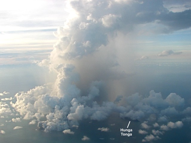 |
Figure 1. Aerial photograph showing the eruption plume from Hunga Ha'apai island at 1804 on 17 March 2009. The island of Hunga Tonga is the dark linear feature at lower right. Courtesy of Steven Gates. |
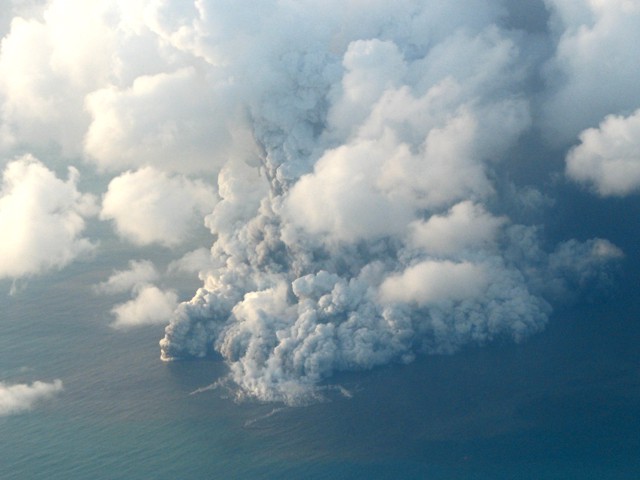 |
Figure 2. Closeup aerial photograph of the Hunga Ha'apai eruption at 1804 on 17 March 2009. Horizontal plumes on the ocean, tephra fallout, and discolored water can be seen. Courtesy of Steven Gates. |
According to Matongi Tonga news, the Tonga Defence Services reported the eruption to the Geological Division of the Ministry of Lands on 17 March. Government geologist Kelepi Mafi noted that "sharp tremors" had been recorded by their seismic instruments during the previous three weeks, though the seismicity could not be directly linked to the eruption. Quotes by Mafi indicated that, based on seismicity, the submarine eruption may have started on 16 March. However, initial reports of steam plumes seen on that day were incorrect, as were reports of the eruption being 10 km SW on Tongatapu.
As reported by Agence France Presse (AFP), radio journalist George Lavaka viewed the eruption from a game-fishing boat operated by Lothar Slabon on the afternoon of 18 March. He described an island completely covered in black ash, coconut tree stumps, and dead birds and fish in the surrounding water. Video and photographs taken by passengers on that boat clearly showed a submarine vent offshore to the S and another vent some distance away on the NW part of the island (figure 3). Activity increased during the hour that the boat was present, during which time both vents exhibited strong Surtseyan explosions (figure 4), an eruption type named for Surtsey volcano off the coast of Iceland. As the eruption from the offshore vent became stronger, the plume included larger amounts of steam, produced base surges along the ocean surface, and ejected bombs (figure 5). Fortunately the boat left the area just as the eruption escalated and volcanic bombs began falling around them.
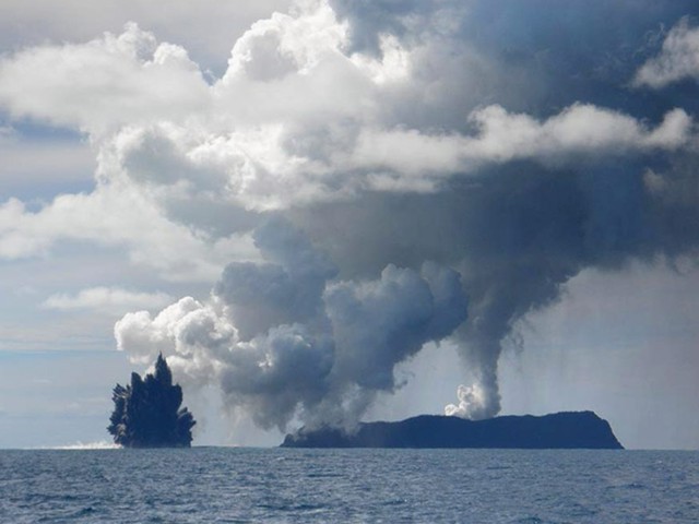 |
Figure 3. Photograph of a steam-and-ash plume rising from Hunga Ha'apai Island and a submarine vent to the S erupting black tephra. View is looking NW on 18 March 2009. Photo from unknown photographer on the Sloban boat provided by Dana Stephenson/Getty Images on boston.com. |
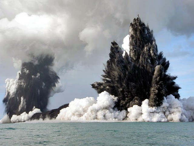 |
Figure 4. Photograph showing dark ash-laden Surtseyan eruption plumes from both Hunga Ha'apai vents. View is looking NNE on 18 March 2009. Photo from unknown photographer on the Sloban boat provided by Dana Stephenson/Getty Images on boston.com. |
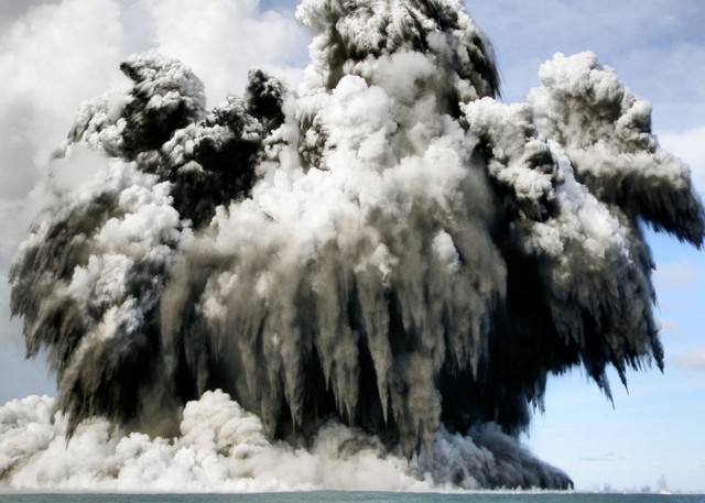 |
Figure 5. Photograph of the offshore Hunga Ha'apai vent during a strong eruptive event on 18 March 2009. Bombs with trailing ash plumes can be seen falling from the eruption cloud, which is producing base surges along the ocean surface. Photo from unknown photographer on the Sloban boat provided by Dana Stephenson/Getty Images on boston.com. |
A science team led by Mafi observed the eruption site at Hunga Ha'apai from a boat on 19 March. By that time, as reported by AFP, tephra had filled the gap between the submarine vent, originally about 100 m offshore, and the island, adding hundreds of square meters of land. Residents on Tongatapu reported orange glow from the eruption on the night of 19 March.
Aviation reports. A New Zealand Dominion Post article on 19 March noted that flights were disrupted and rerouted around the activity following warnings from Airways New Zealand and MetService NZ.
The Wellington VAAC issued an aviation notice on 18 March based on ground observations from the Tongatapu airport of a plume rising to an altitude of 7.6 km at 0659 that morning; ash was not seen in satellite data. Later that day, at 1330, a plume seen on MODIS satellite imagery was within 1 km of the vent and moving NE. A similar plume was reported based on MODIS and ground observations to an altitude of 4.5 km at 1600. Airport observers continued to report a plume to 5 km altitude at 1000 on 19 March, and to 4 km at 1700, but with a band of ash extending 2.5 km NE from the volcano to 2.4 km altitude.
D. Tait, a pilot for Air Chatham, noted that at 1700 on 19 March frequent eruptions were ejecting black ash, sometimes to a height of 300 m. The main white eruption plume was rising to about 4 km altitude and drifting ENE, to a distance of almost 500 km as seen in MODIS satellite imagery. He also observed that widespread ash and haze was trapped below an inversion layer at about 2 km altitude. On 20 March, a VAAC report at 1140 indicated a steam plume to 4 km but no visible eruption.
Pilot Tait reported that at 1015 on 21 March the island was covered by weather clouds, the crater was not visible, and there was no vertical plume; haze was again below an inversion layer at 1.5 km altitude. No eruptions were seen during the 15 minutes the island was visible on the return flight around 1250. However, steaming continued, with the plume rising to 1.8 km altitude. A new eruptive episode was reported by Tongatapu airport observers at 1409 on 21 March that sent an ash plume 800 m high.
Information Contacts: Steven Gates, Tradewind Island Sailing, Private Bag 63, Neiafu, Vava'u, Tonga (URL: http://www.manuoku.com/); Wellington Volcanic Ash Advisory Centre (VAAC), Meteorological Service of New Zealand Ltd (MetService), PO Box 722, Wellington, New Zealand (URL: http://www.metservice.com/ vaac/, http://vaac.metservice.com/); The Dominion Post (URL: http://dompost.co.nz/); Matongi Tonga Online, PO Box 958, Nuku'alofa, Tonga (URL: http://www.matangitonga.to/); Agence France Presse (AFP) (URL: http://www.afp.com/); The Boston Globe, Boston, MA, USA (URL: http://www.boston.com/).
Eruption ends on 21 March, leaving new land and steaming lakes
The eruption from Hunga Tonga-Hunga Ha'apai (figure 6) that began from multiple vents at Hunga Ha'apai island on 17 March 2009 ended after five days of activity on 21 March. The eruption destroyed all vegetation on the island, one of two high points on a submarine caldera rim (figure 7). Strong Surtseyan activity was witnessed by passengers on a fishing boat on 18 March (BGVN 34:02). Satellite imagery acquired that day (figure 8) revealed a bright eruption plume, an extensive 10-km-radius zone of discolored water around the islands, and pumice rafts that had already drifted 20-25 km towards the NW. By the next day, scientists on the scene observed that the submarine vent offshore to the S (figure 9) had built new land that was connected to Hunga Ha'apai (BGVN 34:02).
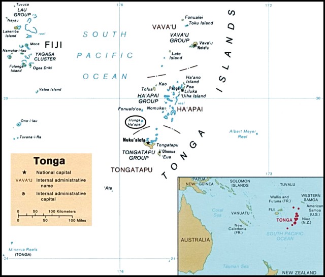 |
Figure 6. Political map of Tonga, 1989, showing the Vava'u, Ha'apai, and Tongatapu island groups. Hunga Ha'apai is in the oval about 55 km NNW of Tongatapu Island. Map courtesy of the University of Texas Libraries, The University of Texas at Austin. |
 |
Figure 7. Aerial photo showing the vegetated islands of Hunga Tonga (right) and Hunga Ha'apai (left) before the eruption. Courtesy of Brad Scott, GNS Science. |
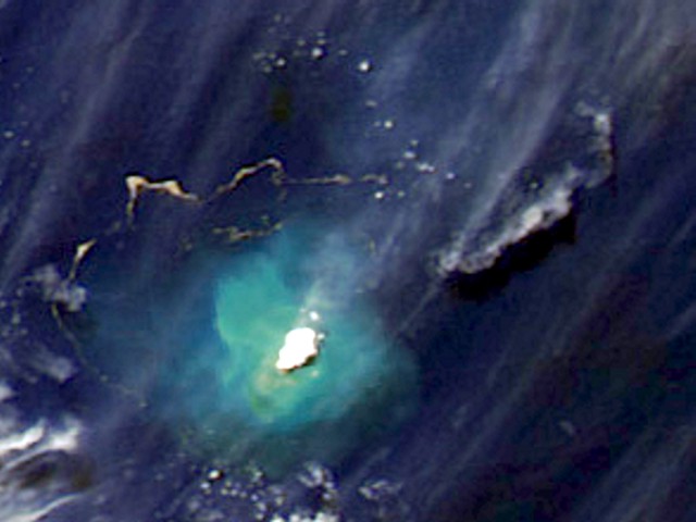 |
Figure 8. Aqua MODIS satellite image showing the eruption plume drifting NE and pumice rafts from Hunga Ha'apai on 18 March 2009. Hunga Tonga and Hunga Ha'apai are covered by the bright steam plume and surrounded by discolored water caused by suspended sediments reaching a maximum of about 10 km from the island. A detached older plume, possibly ash-bearing, is to the NE. Serpentine-shaped pumice rafts are drifting in the NW sector at a distance of 20-25 km from the island. Contrast has been enhanced. Courtesy of NASA Earth Observatory. |
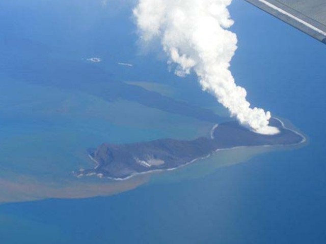 |
Figure 9. Aerial photo showing the island of Hunga Ha'apai with a steam plume rising from the vent in the newly created portion of the island. Emissions can also be seen in the vicinity of the small lake (left) marking the location of another vent active during this eruption. Discolored water surrounds the island, but a denser plume of material is originating from the shoreline near the small lake. View is looking SSE on an unknown date, March 2009. Courtesy of AusAID in Tonga. |
Based on inspection of an aerial photograph taken on 21 March (figure 10), the island had lengthened by ~ 1 km and the S crater was approximately 350 m in diameter on 21 March, assuming the island was 2 km long as previously described. Calculations using ASTER satellite imagery from 26 March result in similar dimensions for the island and S crater, and showed that the new extension was also about 1 km wide at that time.
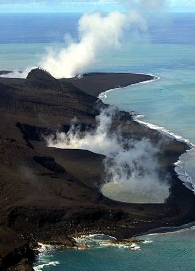 |
Figure 10. Aerial photo of the W side of Hunga Ha'apai island showing two steaming lakes in the NW vent area and a steam plume rising from the vent on the new southern part of the island. View is to the S on 21 March 2009. Courtesy of GP Orbassano and the Waterfront Lodge. |
Aerial photographs from 21 March showed no activity at the NW vent and a steam plume rising from the S vent. However, airport observers on Tongatapu saw new eruptive activity with ash plumes on the afternoon of 21 March (BGVN 34:02). A Matangi Tonga news article on 1 April reported the eruption as being on 17-21 March. Although Radio New Zealand International reported that residents of Nuku'alofa saw "glow on the horizon" on 22 March and stated that ash eruptions continued on the 23rd, those observations were not confirmed.
On 27 March a group of four people, organized by Gian Piero Orbassano of the Waterfront Lodge, landed on Hunga Ha'apai using an inflatable dinghy launched from a charter fishing boat. They landed on the newly built southern part of the island and walked to the rim of the crater which they described as filled with orange steaming water. They noted that landing on the "rocky black pumice" shore was difficult in rough seas. Large boulders (sizes not given) on the surface crumbled when touched. The ground was firm to walk on, but the crater rim was "fragile and cracked" (figure 11). Orbassano, in a 5 April news report, stated that people were visiting the island by boat but not landing, viewing the "smoking" vents and yellowish water around the island.
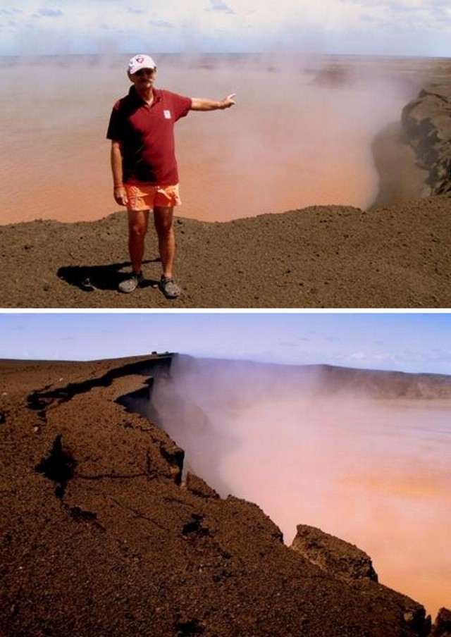 |
Figure 11. Photographs of the southern crater lake on newly formed land at Hunga Ha'apai, 27 March 2009. The steaming lake was colored orange-brown and the rim was unstable, as evidenced by the irregular rim, steep cliffs, and fractures. Courtesy of GP Orbassano and the Waterfront Lodge. |
Information Contacts: Brad Scott, GNS Science, Wairakei Research Centre, Private Bag 2000, Taupo 3352, New Zealand (URL: http://www.gns.cri.nz/); NASA Earth Observatory (URL: http://earthobservatory.nasa.gov/); GP Orbassano, Waterfront Lodge, Vuna Road, Ma'ufanga, PO Box 1001, Nuku'alofa, Tonga (URL: http://www.waterfront-lodge.com/); Radio New Zealand International, PO Box 123, Wellington, New Zealand (URL: http://www.rnzi.com/); Matongi Tonga Online, PO Box 958, Nuku'alofa, Tonga (URL: http://www.matangitonga.to/); Perry-Castañeda Library Map Collection, University of Texas Libraries, The University of Texas at Austin (URL: http://www.lib.utexas.edu/).
December 2014 to January 2015 eruption at submarine caldera builds new land above water
A submarine eruption began here by 19 December 2014 and ended by 28 January 2015. Hunga Tonga and Hunga Ha'apai are small islands situated on the rim of a submarine caldera known by the names of the two islands (Hunga Tonga and Hunga Ha'apai) (figure 12). The 2014-2015 surtseyan eruption added a circular area of land over 100 m in elevation at a spot S of and about midway along Hunga Ha'apai island's length. The new island initially grew as an isolated third new island, but subsequently connected and joined with Hunga Ha'apai. The area of new land surface eventually reached about 1.5 to 2 km in diameter. The new island also grew to come as close a few hundred meters from Hunga Tonga island. The eruption issued dense ash plumes that generally rose less than about a kilometer in altitude but preliminary estimates on the associated higher, ash poor steam plumes rose to 7-10 km altitude.
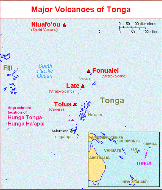 |
Figure 12.(Inset) A map showing a large scale view of the South Pacific with the Kingdom of Tonga highlighted in purple. (Main map) Hunga Tonga and Hunga Ha'apai lie on the rim of a submarine caldera located 65 km N of a wharf in the harbor at Nuku'alofa, Tongatapu island (the main island of the archipelago). Nuku'alofa is a deep-water port, the nation's capital, and Tonga's economic hub. Tongatapu island also hosts an international airport, which sits to the S of the capital. (The word "Ha'apai" is also used as the name of a region of islands and reefs well N of Hunga Tonga-Hunga Ha'apai.) The volcano also lies ~70 km SW of Normuka island. Courtesy of USGS. |
This 2014-2015 eruption followed 5 years of quiescence, the previous eruption having occurred in 2009 (BGVN 34:03). That 2009 eruption formed new land above water and deposits destroyed vegetation on neighboring Hunga Tonga and Hunga Ha'apai islands (BGVN 34:03). The 2009 eruption added land at the S end of Hunga Ha'apai island. New research has been published discussing the 2009 eruption since our earlier report (BGVN 34:03). For example, Allen and Riebeek (2009) issued a 28 March 2009 Earth Observatory picture of the day that featured Hunga Tonga-Hunga Ha'apai images depicting the island morphology before and after the eruption. For another example, Vaughan and Webley (2010) discussed satellite observations associated with the 2009 eruption. Bohnenstiehl and others (2013) also discussed marine acoustic signatures from the 2009 eruption.
A key source used to create this report on the 2014-2015 eruption consists of four reports created by the Tongan Ministry of Information and Communications (MIC) and released during 14-28 January 2015. Those four MIC Advisories (numbers 3, 4, 5, and 6) are hereafter referred to as MIC (2015 a, b, c, and d). MIC 3 (2015a) was issued 14 January looking back in time at key aspects of the eruption. Discussions included the location and behavior of the first seen early observations on 20 December 2014, a site visit by the Tongan Navy on 6 January, and a pilot report on 13 January 2015. MIC 4 (2015b) was issued on 19 January describing a visit made on 14 January. This was the first report of the existence of a new island. By this time the new island had attached to Hunga Ha'apai island, roughly doubling the size of that island. MIC 5 (2015c) was also issued on 19 January. It described observations made from a visit aboard a ship (the VOEA Neiafu) on 17 January. MIC 6 (2015b) issued on 28 January describing for a visit on 24 January 2015. The report noted a lack of ash, gas, or steam coming from the vent that formed the new island. The authors concluded that the eruption "appears to be over." They provided a sketch map of the new island.
There were no new MIC reports during February-March 2015. The visits and reporting drew on support that included the Tonga Meteorological Services, NZ-Meteorological Services, the Tongan Navy, National Emergency Management Office, Tonga Broadcasting Commission, the New Zealand High Commission, and Ministry of Lands and Natural Resources, Tonga Airport Limited, Tonga Meteorological Services, GNS-NZ, NZ-Meteorological Services, and possibly others.
Eruption, December 2014. The online newspaper Matangi Tonga on 30 December noted that fishermen observed an eruption near Hunga Tonga-Hunga Ha'apai on 19 December 2014 (Matangi Tonga, 2014). An editor from that publication, Mary Lyn Fonua, notified GVP of the eruption. The same publication issued over 10 reports during 30 December 2014 through at least 9 March 2015 (Matangi Tonga, 2014, 2015a, b, c).
MIC (2015a) was released at 0943 on 14 January; it reported the position of the vent that was active on 20 December. Figure 13 is a later version of their figure, made at higher resolution. MIC (2015a) described this particular area as venting steam and sulfurous-gas at the sea surface. Emissions here did not persist during the later stages of the eruption.
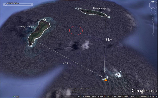 |
Figure 13. A map (N to top) showing the location of steaming at Hunga Tonga-Hunga Ha'apai volcano (orange icon) on 20 December 2014. Each of the two islands are about 2 km long and lie on margins or rim of the mostly submarine caldera, with Hunga Tonga island to the N, and Hunga Ha'apai island to the W of the caldera's center. The area circled in red is the approximate location of the vent that later formed a new rapidly growing island. Taken from Culture Volcan (2015). |
Klemetti (2014) showed an image from a MODIS instrument aboard the Aqua satellite that captured of the area of the eruption on 29 December 2014 (figure 14). A small white plume was in evidence at the volcano in the image. He commented that the area of discolored water stretching to the S could be due to the eruption.
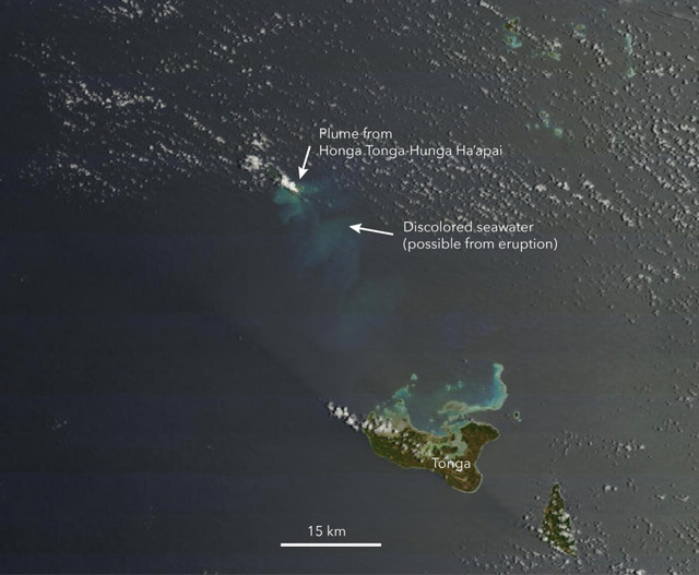 |
Figure 14. The eruption plume from Hunga Tonga-Hung Ha'apai seen on 29 December 2014 by Aqua's MODIS Imager. Image by NASA with annotations by Erik Klemetti (Klemetti, 2014). |
According to Metangi Tonga (2014) on 30 December 2014, "A continuing eruption from Tonga's active undersea volcano, Hunga Ha'apai, was clearly visible on the horizon northwest of Tongatapu today."
Activity during January 2015. During the 6 January visit (MIC, 2015a), observers nearing the volcano saw vigorous venting at a new location. MIC (2015a) did not disclose whether a new island had yet emerged but later reporting mentioned below did clearly document an island. The sea (or perhaps a very low island) discharged vigorous emissions of black ash and white billowing clouds. The new location was situated farther N, much closer to the preexisting islands, than the vent indicated in figure 13. That submarine vent to the S lacked further indications of steam emission during the course of the eruption. Neither of the preexisting islands appeared to contain active vents.
MIC (2015a) contained 11 captioned photos, but most are somewhat hazy and with limited contrast, conditions explained later (MIC, 2015b) as due to rain. Plumes on the 6th rose up to 2 km, but almost all the plumes in the photos were under 1.3 km altitude. At least one photo appeared to capture two low, vertical and parallel plumes. The photos documented some highly non-vertical black plumes, some peculiar low white plumes that seem to rise suddenly at distance, black plumes that appear to contain abundant clasts in their leading edge, low billowing clouds that encircle the darker ones and hug the water surface. In one case (figure 9 of MIC, 2015a) they reported that a white plume with its basal portion hugging the sea surface extended E over 3 km. The captions to their figures 10 and 11 indicated pulsing phenomena..
On 12 January 2015, Wellington VAAC reported ash from Hunga Tonga-Hunga Ha'apai reached an altitude of 6 km. They reported that fallout from the plume turned the sea surface red. Brief discussion of red colored sea surface is again mentioned below, both associated with observations on 14 January 2015 and briefly in a quote in an article by Field (2015).
The Wellington VAAC issued graphics to illustrate observed plume location and possible plume dispersal (figures 15 and 16). On figure 15 they labeled the altitude of the plume as SFC/FL200 (20,000 feet, ~6 km). The label "10/0500Z OBS" refers to the coordinated universal time (UTC) when the plume was observed. The next three cartoons represent movement of the ash plume at 6-hour intervals. The VAA graphic in figure 16 is based on the ash advisory mapping shows the recommended area of avoidance and several flight routes in the area.
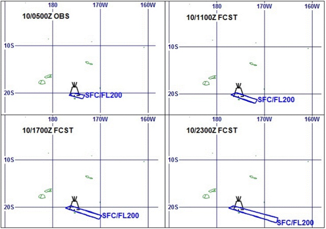 |
Figure 15. Wellington VAAC Ash Advisory maps produced to describe the Hunga Tonga-Hunga Ha'apai plume and its trajectory. Times and dates are UTC (e.g., "10/0500Z" corresponds to 10 January 2015 at 0500 UTC). (Upper left) This is the observed ("OBS") ash plume's margin, which was traced onto this map from satellite image. This is the starting point for the subsequent forecasts. (Upper right) The forecast ("FCST") plume after 6 hours. (Lower left) The forecast plume after 12 hours. (Lower right) The forecast plume after 18 hours. Courtesy of the Wellington VAAC. [Maps extracted from NZ Met Service website (OBS-Observed; FCST, Forecasted) (http://vaac.metservice.com/vag/243040-2015_19)]. |
 |
Figure 16.Wellington VAAC graphic showing the Hunga Tonga-Hunga Ha'apai ash plume boundararies for 12-13 January 2015 as an area enclosed in a blue polygon. The curved black lines in the center and at right are flight paths. Taken from the Wellington VAAC graphic for 12-13 January 2015. |
MIC (2015a) noted that all international flights on 13 January 2015 were cancelled, though the domestic airline was operational. A Tongan government daily media release on 13 January described the ongoing eruption and cancellation of flights: "Activity continues at the Hunga Ha'apai-Hunga Tonga region and the emission of ash is reported to have escalated. Volcanic ash is forecasted to reach 870 km in 80 km wide toward the ESE from the Hunga Ha'apai-Hunga Tonga Region. By 11 January 2015, Real Tonga Airlines cancelled their flights for the day." Similar discussions of flight cancellation occurred around this time in Matangi Tonga, in their reports for 9, 13, 14 January.
On 13 January 2015 the Australian Aviation blog reported numerous flight cancellations, including Air New Zealand, Fiji Airways, and Virgin Australia. They also reported resumed service on 14 January 2015. According to Matangi Tonga (2015a) flights resumed on 15 January.
MIC (2015b, one of two reports issued on 19 January) discussed a site inspection on 14 January using a Tongan Navy vessel. The 14 January observations conveyed in MIC (2015b) noted that continuous volcanic eruptions had created a new island (figure 17). On 14 January the volcano was erupting about every five minutes. Ash and rock were ejected to a height of about 400 m above the sea surface. Wet ash was deposited close to the vent, building up the new island. Hazardous surges of ash and steam spread out horizontally during eruptions, and extended more than 1 km from the erupting vent (figure 18). Ash and acid rain fell in an area of ~10 km surrounding the eruption.
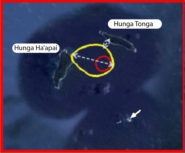 |
Figure 17. Sketch map of Hunga Tonga-Tonga Ha'apai as seen during a 14 January 2015 site inspection. The arrow points to the initial vent seen on 20 December 2014. The red circle indicates the location of the later vent that erupted for about a month, constructing an island with above water extent on 14 January 2015 in the area within the yellow circle. The circle is roughly 2 km in longest dimension. On the basis of this map, the minimum distance between Hunga Tonga island and the new land scales to ~300 m. Modified from MIC (2015b). |
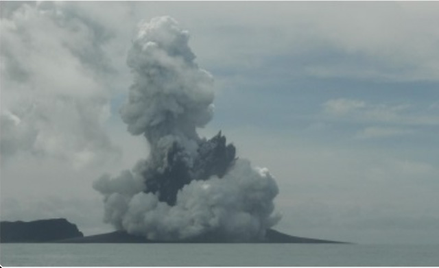 |
Figure 18. The new island amid eruption on 14 January 2015. The view is looking NE and the steep high area is Hunga Ha'apai island, which resides in behind the new island. The plume was made up of discrete white and dark components. From this perspective the vent appears to sit in the midst of the new low island. Photo taken on 14 January 2015 from the Tongan naval vessel ~300 m offshore (MIC, 2015b). |
MIC (2015b) noted that on 14 January steam rose over 1 km and was noted by pilots. The eruption continued to emit ash but in recent days the presence of ash has been limited to low elevations. An early summary section in the report also include the following.
"The new island is more than 1 km wide, ~2 km long and about 100 m high. During our observations the volcano was erupting about every 5 minutes. Dense ash was being erupted to a height of about 400 m, accompanied by some large rocks. Higher we observed mostly steam, but with some ash. Above about 1000 m, the eruption plume was almost exclusively steam. As the ash is very wet, most is being deposited close to the vent, building up the new island.
"Hazardous surges of ash and steam were seen to spread out horizontally during eruptions, and these extended more than 1 km from the erupting vent.
"Ash fall and acidic rain was observed within 10 km of the eruption. Leaves on trees on Hunga Tonga and Hunga Ha'apai have died, probably caused by volcanic ash and gases.
"No large rafts of pumice or other floating volcanic debris were observed. Strong smells of volcanic gases were noticed on a few occasions.
"This eruption is similar to that at Hunga Ha'apai in 2009, but only producing larger volume of materials resulting in the size of the island.
"It is unclear at this stage if there is any relationship between the eruption and a red algal bloom observed in seawaters around Tonga recently."
Field (2015) contained an image from the 14 January site inspection (figure 19).
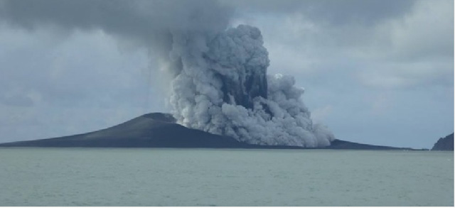 |
Figure 19. Hunga Tonga-Hunga Ha'apai eruption viewed from a Tongan naval vessel N of the island on 14 January 2015. Taken from Field (2015) with photo credit there given to the New Zealand High Commission in Tonga. |
On 14 January Matangi Tonga (2015b) reported more details on the algal bloom mentioned above (the cause of which remains uncertain). Matangi Tonga (2015b) also reported unusual optical effects seen on the E facing side at the NE end of Tongatapu island (Kanokupolu beach) around that time. The article said the bloom "...turned the seas frothy white, chocolate and red..." and "...the sun shone through a champagne sky." The article contained photos by Shane Egan documenting these effects. Algal blooms can in some cases be detected and tracked by remote sensing as exemplified by Mantas and others (2011), who discuss remote sensing of algal communities as a possible cause of discolored water associated with the Home Reef eruption of 2006.
MIC (2015c) discussed a site visit conducted aboard a naval vessel on 17 January 2015. The authors noted that the eruption still continued at the new island during the visit. MIC (2015c) further stated the following. "During most of our time near the island, strong emission of steam to heights of 7–10 km was observed, but with only limited amounts of ash. Later, some eruptions that threw dense, wet ash, and small rocks 200-300 m into the air, accompanied by further strong emissions of steam. Hunga Tonga and Hunga Ha'apai islands were covered by ash from the eruption over the last month. The eruptions observed today were too small to deposit ash on those islands, suggesting that the eruptions a week or two ago were probably substantially stronger than those observed [on the 17 January site visit]. No trace of rafts of pumice or other floating volcanic debris was observed. No strong smells of volcanic gases were noticed within 3.7 km of the site, it was noticed however 27-47 km on the way to the site. The style of this eruption is similar to that at Hunga Ha'apai in 2009, but the volume of material erupted this time is much greater. International and domestic flights have operated without interruption in the last few days."
On 19 January 2015, the Pléiades satellite captured the Hunga Tonga-Hunga Ha'apai eruption. France's Centre National d'Etudes Spatiales (CNES) issued the resulting 50 m resolution images of the new land created by Hunga Tonga-Hunga Ha'apai's latest eruptions (figure 20). Hunga Tonga island in on the upper right; and Hunga Ha'apai, center left. In the center of the image is a nearly circular, gray colored area, which is the newly created land attached to Hunga Ha'apai island. The vent area on the new island was filled with water (green). Ash from the eruption covered extensive areas of the vegetation on both islands. This and other Images were featured in the article Airbus Defense and Space (2015).
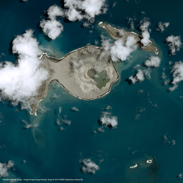 |
Figure 20. CNES Pléiades satellite image (50-m resolution, optical band) taken on 19 January 2015. Ejecta from the new crater connects it to the E side of Hunga Ha'apai (island at left). Taken Airbus Defense and Space (2015) with data acquisition credit to CNES. |
MIC (2015d) was issued on 28 January 2015 summarizing a 24 January site visit, which found the eruption over by this time. Figure 21 shows where the new land surface joins the preexisting Hunga Ha'apai island. Rough seas prevented landing and limited the trip to observations from the naval vessel. The scientists stated, "The eruption from the new island that started growing over a month ago appears to be over. There were no sign of any emissions of ash, gas or steam observed coming out from the vent of the newly formed island."
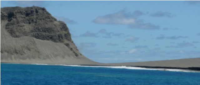 |
Figure 21. The point where new land adjoins the older island as seen in January 2015 after the Hunga Tonga Hunga Ha'apai eruption was over. The steep sea cliff forming the old margin of Hunga Ha'apai island is on the left. In the center and right parts of the image lie a low area of gently sloping gray material, which is an outer portion of the newly created land. Besides creating the new land, ash from the eruption covered vegetation over extensive areas on both the older islands. Taken from MIC (2015d). |
On 13 March 2015, Luntz (2015) reported that on 6 March 2015 GP Orbassano and two other residents of Tonga landed on one of the new land's three beaches. With his son, he climbed to the highest point of the island's crater, which was ~250 m high. According to Luntz (2015), Tonga's lands and Natural Resources Ministry said the newly formed island was 1.3 km long and 800 m wide.
Orbasano smelled sulfurous and other chemical odors. The vent had filled with opaque green water (figure 22). Matangi Tonga (2015c) also reported on this same topic and featured numerous photos.
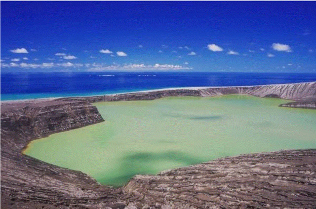 |
Figure 22. The crater lake in the vent area located in the central area of new land as seen on 6 March 2015. Courtesy of Luntz (2015) with photo credit to GP Orbassano. |
Luntz (2015) quoted Orbassano as saying "the ash and rock surface was difficult to walk on due to the channels cut in it" (figure 23).
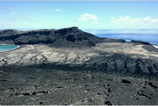 |
Figure 23. The highest peak on the new land as seen as seen on 6 March 2015. Note extensive rills and gullies. Taken from Luntz (2015) with photo credit to GP Orbassano. |
"There are thousands of seabirds--all kinds, laying eggs on the island," Orbassano said (figure 24).
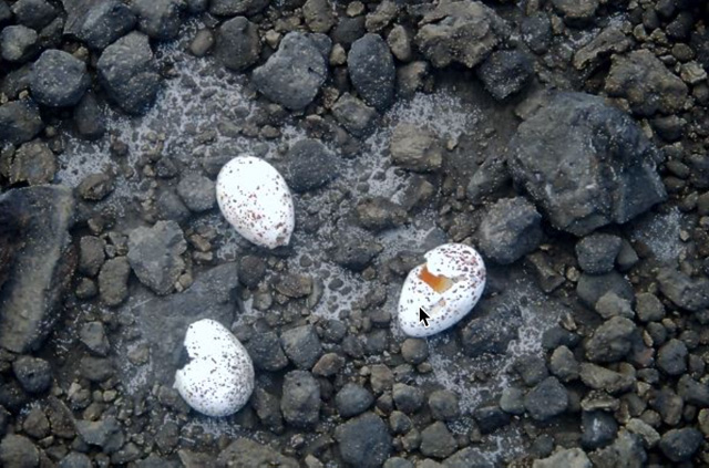 |
Figure 24. On the new land surface at Hunga Tonga-Hunga Ha'apai, these sea bird eggs were found laid directly upon the fragmental deposits. Taken on 6 March 2015. Courtesy of Iflscience and GP Orbassano. |
References. Allen, J, and Riebeek, H, 2009, Submarine Eruption in the Tonga Islands NASA image, (28 March 2009, NASA Earth Observatory, Image of the Day) NASA (URL: http://earthobservatory.nasa.gov/IOTD/view.php?id=37657) (accessed May 2015)
Australian Aviation, 2015, Volcano ash cloud disrupts Tonga flights, Australianaviation.com.au (posted 13 January 2015) (accessed May 2015) (URL: http://australianaviation.com.au/2015/01/volcano-ash-cloud-disrupts-tonga-flights/ )
Airbus Defense and Space, 2015, Eruption of a volcano in the Tonga archipelago, Pléiades captures the birth of a new island (accessed March 2015) (URL: http://www.geo-airbusds.com/en/6322-eruption-of-a-volcano-in-the-tonga-archipelago-pleiades-captures-the-birth-of-a-new-island)
Bohnenstiehl D.R., Dziak R.P., Matsumoto H., Lau T.K. Underwater acoustic records from the March 2009 eruption of Hunga Ha'apai–Hunga Tonga volcano in the Kingdom of Tonga. J. Volc. Geotherm. Res. 2013;249:12-24.
Culture Volcan (Journal d'un volcanophile), 2015, L'activité du volcan Hunga Tonga Hunga Ha'apai a-t-elle changé de style? (posted 14 January 2014) (URL: http://laculturevolcan.blogspot.com/2015/01/lactivite-du-volcan-hunga-tonga-hunga.html)
Field, M, 2015, Tonga volcanic eruption creates new island, Stuff.co, posted 16 January 2015 (URL: http://www.stuff.co.nz/world/south-pacific/65103454/tonga-volcanic-eruption-creates-new-island ).
Klemetti, E, 2014, New Eruption at Hunga Tonga-Hunga Ha'apai, Wired (online), posted 30 December 2014 (accessed 6 June 2015).
Luntz, S, 2015, Newly emerged Pacific "Island" photographed for the first time, IFLSCIENCE (posted 13 March 2015. Accessed March 2015 (URL: http://www.iflscience.com/physics/newly-emerged-pacific-peak-photographed-first-time).
Mantas, V M, Pereira, AJSC., and Morais, PV, 2011, Plumes of discolored water of volcanic origin and possible implications for algal communities. The case of the Home Reef eruption of 2006 (Tonga, Southwest Pacific Ocean). Remote Sensing of Environment, v. 115, no. 6, p. 1341-1352.
Matangi Tonga, 2014, Hunga Ha'apai eruption continues, Matangi Tonga (Posted 30 December 2014; free content accessed in May 2015) (URL: http://matangitonga.to/2014/12/30/hunga-haapai-eruption-continues).
Matangi Tonga, 2015a, Fua'amotu airport's busiest day, as flights resume, Matangi Tonga (Posted 15 January 2015; free content accessed in May 2015) (URL: https://matangitonga.to/2015/01/15/fuaamotu-airports-busiest-day-flights-resume).
Matangi Tonga, 2015b, Nature plays with the sea and sky in Tonga, Matangi Tonga (Posted 15 January; free content accessed in May 2015) (URL: http://matangitonga.to/2015/01/15/nature-plays-sea-and-sky-tonga).
Matangi Tonga, 2015c, New volcanic island attracts sightseers, Matangi Tonga (Posted 9 March 2015; free content accessed in May 2015) (URL: http://matangitonga.to/2015/03/09/new-volcanic-island-attracts-sightseers).
MIC, 2015a, Government of Tonga Ministry of Information and Communication 3 (issued 14 January 2015) (URL: http://www.mic.gov.to/news-today/press-releases/5180-advisory-of-volcanic-activity-no3) (Accessed April 2015).
MIC, 2015b, Government of Tonga Ministry of Information and Communication 4 (issued 19 January 2015) (URL: http://www.mic.gov.to/news-today/press-releases/5185-volcanic-advisory-4) (Accessed April 2015).
MIC, 2015c, Government of Tonga Ministry of Information and Communication 5 (issued 19 January 2015) URL: http://www.mic.gov.to/news-today/press-releases/5183-volcanic-advisory-5) (Accessed April 2015).
MIC, 2015d, Government of Tonga Ministry of Information and Communication 6 (issued 28 January 2015) (URL: http://www.mic.gov.to/news-today/press-releases/5197-volcanic-advisory-6) (Accessed April 2015).
Vaughan, RG, Webley, P, 2010, Satellite observations of a surtseyan eruption: Hunga Ha'apai, Tonga, Journal of Volcanology and Geothermal Research. 12/2010; 198(1-2):177-186. DOI: 10.1016/j.jvolgeores.2010.08.017.
Information Contacts: Tonga’s Ministry of Information and Communications (URL: http://www.mic.gov.to); Tonga’s Natural Resources Division of the Ministry of Lands and Natural Resources (URL: http://www.mic.gov.to/ministrydepartment/14-govt-ministries/lands-survey-nat-res/); Mary Lyn Fonua, Matangi Tonga online (URL: http://matangitonga.to/); NASA Earth Observatory (URL: http://earthobservatory.nasa.gov/); Wellington Volcanic Ash Advisory Centre, NZ Meteorology Service (URL: http://vaac.metservice.com/); Tonga Meteorological and Coastal Radio service (URL: http://www.met.gov.to); GNS Science (formerly New Zealand’s Institute of Geological and Nuclear Sciences Limited), Taupo, New Zealand (URL: http://www.gns.cri.nz/); and GP (Gianpiero(?)) Orbassano, Waterfront Lodge, Vuna Road, Ma'ufanga, PO Box 1001, Nuku'alofa, Tonga (URL: http://www.waterfront-lodge.com/).
Surtseyan explosions begin on 20 December 2021; large ash plumes and island growth
The Hunga Tonga-Hunga Ha’apai volcano includes small islands and shallow submarine reefs along the caldera rim of a much larger submarine edifice in the western South Pacific Ocean (figure 25), west of the main inhabited islands in the Kingdom of Tonga. It is one of 12 confirmed submarine volcanoes along the Tofua Arc, a segment of the larger Tonga-Kermadec volcanic arc. The Tonga-Kermadec arc formed as a result of subduction of the Pacific Plate beneath the Indo-Australian Plate. The capital city of Tonga, Nuku’alofa, is located 65 km S on the island of Tongatapu. New Zealand lies 2,000 km S, and Australia is over 3,000 km SW. Evidence for at least two caldera-forming eruptions was present in the volcanic stratigraphy on the island (Brenna et al, 2022); five eruptions have been documented since 1900. This report provides a summary of previous activity through 2015, followed by information on new eruptive activity that began on 20 December 2021 until a pause in the eruption on 5 January 2022. Subsequent reports will cover details of the large 14-15 January 2022 events. Primary sources of information include the Tonga Geological Services (TGS), Tongan and New Zealand news outlets, the Wellington Volcanic Ash Advisory Center (VAAC), and satellite information from multiple sources.
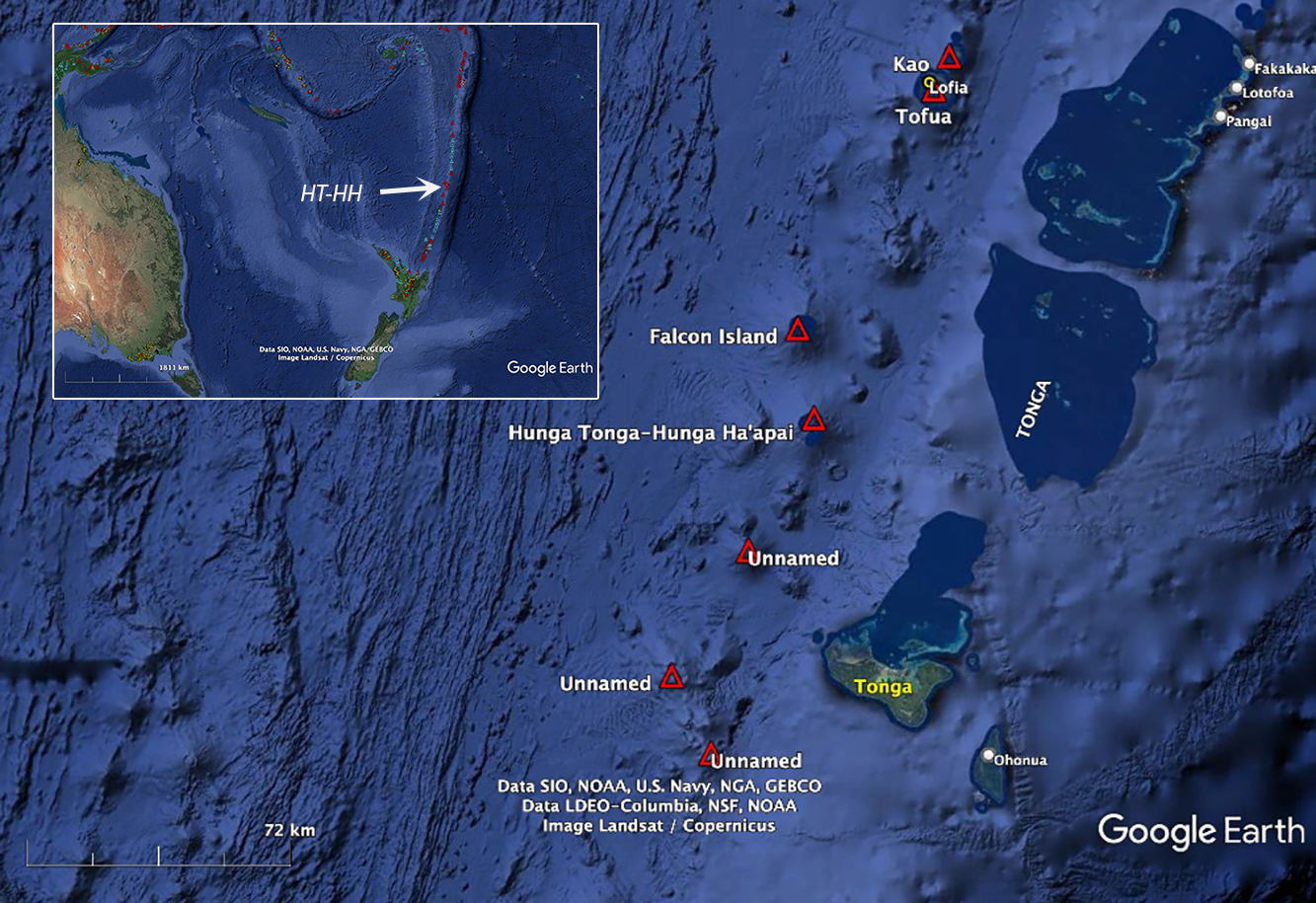 |
Figure 25. Hunga Tonga-Hunga Ha’apai volcano in the SW Pacific is 65 km NW of the island of Tongatapu, where the capital of the Kingdom of Tonga, Nuku’alofa, is located. It lies 2,000 km N of New Zealand and over 3,000 km NE of Australia. Several submarine volcanoes along the Tofua arc are shown in red triangles. The Tonga-Kermadec trench lies to the east of the volcanic arc. Courtesy of Google Earth. |
Eruptive activity during 1912-2015. Eruptions were recorded at Hunga Tonga-Hunga Ha’apai in 1912, 1937, 1988, 2009, and 2014-2015 (figure 26). The eruptions of 1912 and 1937 were located at a group of shallow reefs about 3 km S of Hunga Tonga island (Brenna et al., 2022), on the SE caldera rim. Fisherman witnessed an eruption in June 1988 near the same reefs which included large volumes of dense steam, tephra, and incandescent ejecta (SEAN 13:05). The tephra erupted from three vents, aligned SW-NE, but there was no evidence of an island above sea level after the activity subsided.
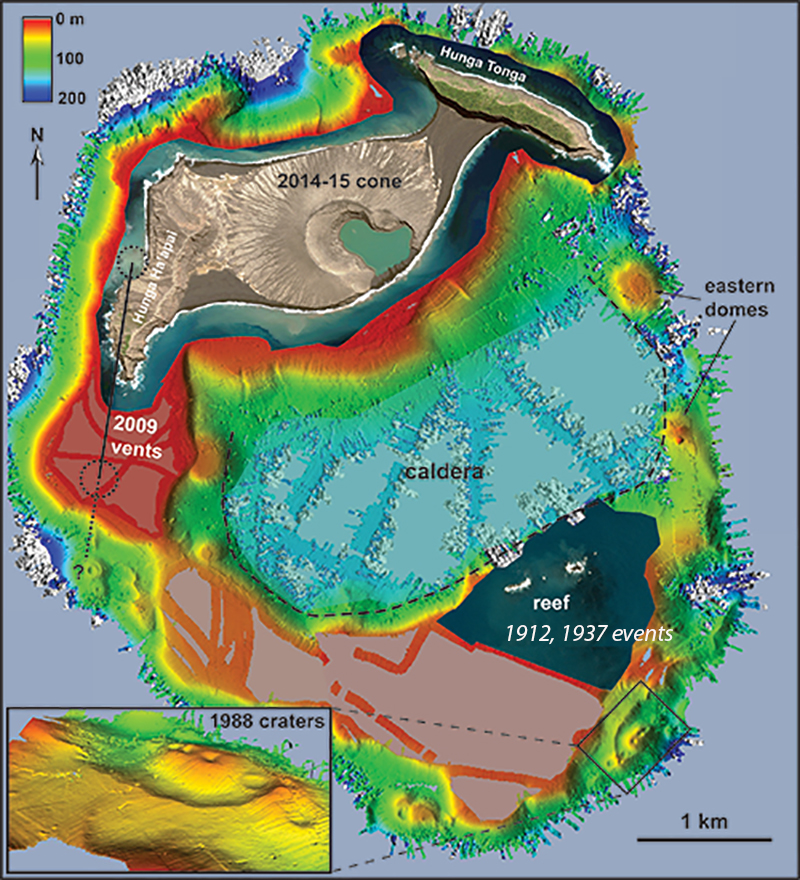 |
Figure 26. A bathymetric sonar survey of the seafloor near the islands of Hunga Tonga and Hunga Ha‘apai, conducted in November 2015, shows the summit platform of the submerged volcanic edifice and the locations of recorded eruptions. The dashed black line outlines a previous caldera which lies 150-180 m below the surface. Traces of past eruptions along the caldera rim are clearly visible; the inset gives the locations of the 1988 eruptions in greater detail. Areas colored white represent depths greater than 200 m, beyond the range of the sonar system. Modified from figure 2 in Cronin et al.(2017). |
In March 2009 a new eruption that lasted for several days was witnessed by airline passengers in the vicinity (BGVN 34:02). Dense steam plumes, both rising vertically and spreading across the water surface, were accompanied by black ash-laden eruption plumes from two separate vents that rose as high as 7.6 km altitude and drifted NE. Pumice rafts drifted tens of kilometers from the site. By the time activity subsided, a new vent had emerged above sea level, extending Hunga Ha’apai island by about 1 km to the S. The crater of the new vent was about 350 m in diameter and began to erode away soon after it formed. The second vent was located immediately W of the island (figure 27). By November 2013 there was no longer any trace of the vents from the 2009 eruption (figure 28).
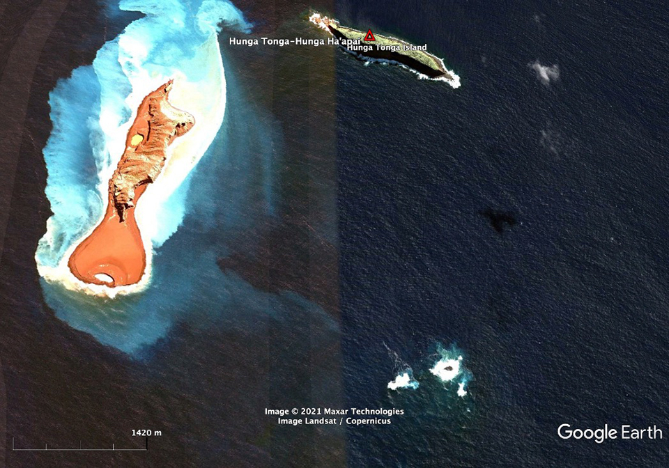 |
Figure 27. Satellite image of the separate islands of Hunga Tonga (top right) and Hunga Ha’apai (left) on 14 June 2009. Two craters formed in the March 2009 eruption; one is immediately W of the center of the island, and the second, about 1 km S of Hunga Ha’apai, was about 350 m wide. They began to erode as soon as they formed and had lost significant volume by three months later when this image was captured. The reefs in the lower right are the site of the 1912 and 1937 eruptions. Vertical lines of different color are processing artifacts of older images. Courtesy of Google Earth. |
 |
Figure 28. Hunga Tonga (top right) and Hunga Ha’apai (left) islands on 14 November 2013 after material added to Hunga Ha’apai during the 2009 eruption had eroded away. Courtesy of Google Earth. |
An eruption during December 2014-January 2015 (BGVN 40:01) built a pyroclastic cone over 100 m in elevation in the area between Hunga Ha’apai and Hunga Tonga islands; it initially created a separate island but was later joined to the others (figure 29) due to water moving the unconsolidated tephra. Fishermen had first observed this eruption in mid-December, and a kilometer-high steam plume was visible from Tongatapu on the 30th. Vigorous emissions of black ash and billowing white clouds were reported on 6 January 2015, with plumes below 2 km altitude. Activity increased during 12-14 January, producing 6-km-high plumes and causing cancellation of numerous airline flights. Repeated explosions ejected rock and ash 400 m above the ocean and produced multiple basal surges that extended up to 1 km out from the vent. Ashfall was noted in a 10 km radius, destroying vegetation on both islands. By 17 January steam emissions were rising to heights of 7-10 km but contained only minor amounts of ash; the new island was quiet when visited by Tongan officials on 24 January.
 |
Figure 29. This CNES Pléiades satellite image (50-m resolution, optical band) taken on 19 January 2015 shows the new island formed during the December 2014-January 2015 eruption. Tephra from the new cone joins it to the E side of Hunga Ha'apai island on the left, while it is not yet connected to Hunga Tonga island on the right. Accessed in March 2015 (figure 20, BGVN 40:01). |
Bathymetric mapping in April 2016 clarified the extent of the submarine portion of the edifice, which rises more than 2,000 m from the surrounding seafloor (figure 30). No volcanic activity was reported from February 2015 through November 2021; satellite imagery acquired during this time shows gradual erosion of the 2015 cone, and continued growth of the beach areas from ocean currents around the island.
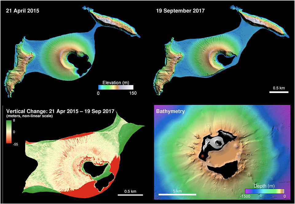 |
Figure 30. Digital Elevation Models (DEMs) of Hunga Tonga-Hunga Ha’apai from April 2015 and September 2017 (top row) indicated the extent of erosion and sediment redeposition that occurred during that time. The lower left panel illustrates the difference of the two DEMs illustrated above, with areas of erosion in red and accretion in green (with levels shown in meters). The lower right panel depicts the bathymetry (5 m ground sample distance) of the larger submarine edifice, as measured from the R/V Falkor in April 2016. The red asterisk indicates the location of the 2009 eruption (Vaughan and Webley, 2010) which washed away after a few months. Original is figure 3 in Garvin et al. (2018). |
Eruptive activity during 20 December 2021-5 January 2022. Tonga's head geologist, Taaniela Kula, confirmed that an ash eruption from Hunga Tonga-Hunga Ha’apai started at about 0935 local time on 20 December 2021 according to the Matangi Tonga Online news website. The initial plume, described as primarily steam and gas without identifiable ash, and having a 30-km radius, was reported by the Wellington VAAC at about 6 km altitude. Kula reported it rising to 16 km later in the day and drifting N; he also told RNZ Pacific that by the afternoon “ash had dusted the whole of Tonga.” He further noted that the plume had reached the Vava’u Islands (250 km NE) and Fonualei Island (300 km NNE) before 1700, it reached Niuafo’ou (550 km N) by 1900, and Niuatoputapu and Tafahi Islands (550 km NE) by 2100 that evening. On Vava’u loud explosions were noted by Scott Bryan several times a minute for the first 1-2 hours; they continued to be heard for 12 hours after the eruption began. Images from Himawari-8 and Korean GeoKompsat weather satellites, and photography from air passengers, confirmed a high-altitude plume (figure 31).
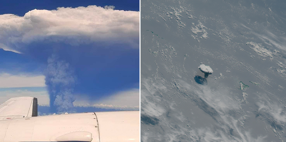 |
Figure 31. Ash and steam rose as high as 16 km from Hunga Tonga-Hunga Ha’apai on 20 December 2021 (local time). Left photo by air passenger Kimberlyn Hoyla on a flight between Tongatapu and Vava’u, courtesy of The Pacific Newsroom. Satellite image (right) from Korea's GeoKompsat weather satellite courtesy of Simon Proud. |
Lightning in the eruption plume was observed from Nuku’alofa on Tongatapu (65 km SE) overnight on 20-21 December. By the next morning the ash cloud had dispersed and a steam-rich plume at 12.2 km altitude was detected drifting NE in satellite imagery; it was also clearly visible from Tongatapu (figure 32). A Maxar satellite image taken on 21 December confirmed that the new vent was very close to the 2014-2015 site, and also showed dark tephra within the plume (figure 33). Pilots reported intermittent eruption plumes ranging from 6-12 km altitude that day; weather satellites also detected continuous pulses of plumes. Multiple bursts of lightning continued to be reported during the next several evenings, visible from Nuku'alofa and the Kanokupolu coast (figure 34).
 |
Figure 32. A steam-rich plume from Hunga Tonga-Hunga Ha'apai rising several kilometers high was seen from Kanokupolu Beach, Tongatapu, at about 1530 on 21 December 2021. Photo by Shane Egan, courtesy of Matangi Tonga Online. |
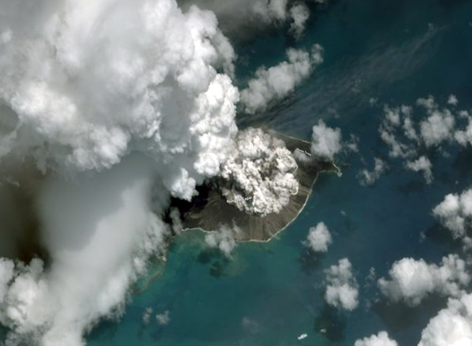 |
Figure 33. Maxar Technologies imagery from 21 December 2021 of Hunga Tonga-Hunga Ha’apai confirmed that the new eruption emerged from the same general area as the 2014-2015 vent. Courtesy of Murray Ford and Maxar Technologies. |
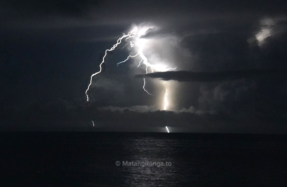 |
Figure 34. Intermittent lightning from Hunga Tonga-Hunga Ha'apai was seen by many Nuku'alofa residents on the evening of 22 December 2021. Photo by Mary Lyn Fonua, courtesy of Matangi Tonga Online. |
The Tonga Geological Services (TGS) reported to Matangi Tonga Online that plumes with sulfur dioxide continued to spread over the Ha'apai, Vava'u, and Niuatoutapu island groups on 22 and 23 December, drifting NNE at altitudes of 8-14 km. They noted that the steam plumes were significantly less dense by the morning of 23 December. The Wellington VAAC reported plumes still visible in satellite imagery at 10.9 km altitude drifting NE early that day but dropping to 6 km altitude later. The first ground-based images of the eruption came from a Tonga Navy crew near the island on 23 December. They recorded Surtseyan explosions ejecting tephra 350 m high, billowing steam plumes rising kilometers, and steam bursts travelling horizontally out from the vent (figure 35). Pulses of steam and gas emissions continued rising to 10.3-12.2 km altitude during 24-27 December, while ash rose only to 3 km; ashfall was confined to the vicinity of the volcano. Tonga’s head geologist reported to RNZ Pacific that satellite images from 25 December showed that the island had grown 300-600 m on the E side, and ash was falling within a 10 km radius. Air travel to Tonga was interrupted by eruption plumes multiple times during the second half of December.
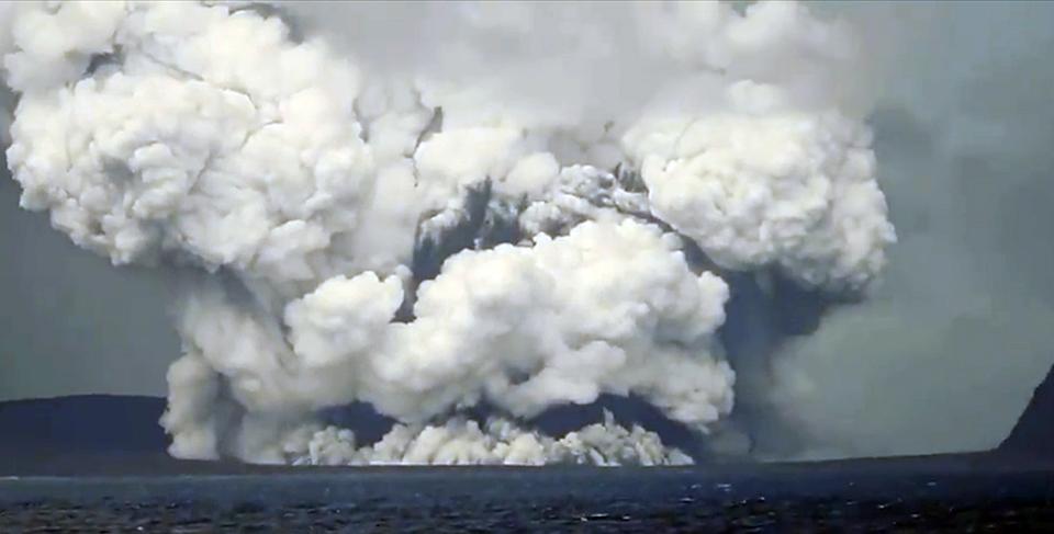 |
Figure 35. Video of Hunga Tonga-Hunga Ha’apai erupting on 23 December 2021 was taken by Sione Vailala Lataimaumi of His Majesty’s Armed Forces of Tonga. This screenshot shows dark tephra being ejected several hundred meters above the vent while billowing steam plumes rose several kilometers and extended horizontally along the ocean surface. Courtesy of Alakihihifo Vailala. |
The altitude of the upper-level steam and gas plumes decreased to 9 km during 27-28 December; a pulse later in the day increased the altitude of the ash cloud from 3 to 3.7 km and the steam and gas cloud to 16 km. Matangi Tonga Online reported powerful lightning bursts overnight on 28-29 December, and volcanic ash was detected 1-7 km above sea level. The ash cloud was reported at 6.1 km altitude early on 29 December, but from midday onward, only steam and gas drifting N at 7.6-12.2 km was reported by the Wellington VAAC. TGS reported on 29 December that the eruption continued intermittently throughout the day, with steam and gas plumes containing small amounts of ash drifting NNW at altitudes up to 18 km. Ash was detected in satellite imagery within 40 km of the vent in all directions in the morning. Passengers on a small South Seas Charters boat witnessed multiple Surtseyan explosions on 29 December with jets of black tephra and dense steam rising up and out from the vent, and ash falling from the drifting plumes (figure 36). Several surges of Surtseyan activity, with some periods lasting as long as 30 minutes, occurred overnight during 29-30 December local time; similar activity during the midday of 30 December was photographed by TGS (figures 37 and 38). The ash and steam drifted N, passing to the W of Tofua (90 km NNE), Kao (100 km NNE), and Late (200 km NNE) islands. Rafts of pumice were seen floating in the water several kilometers from the vent (figure 39).
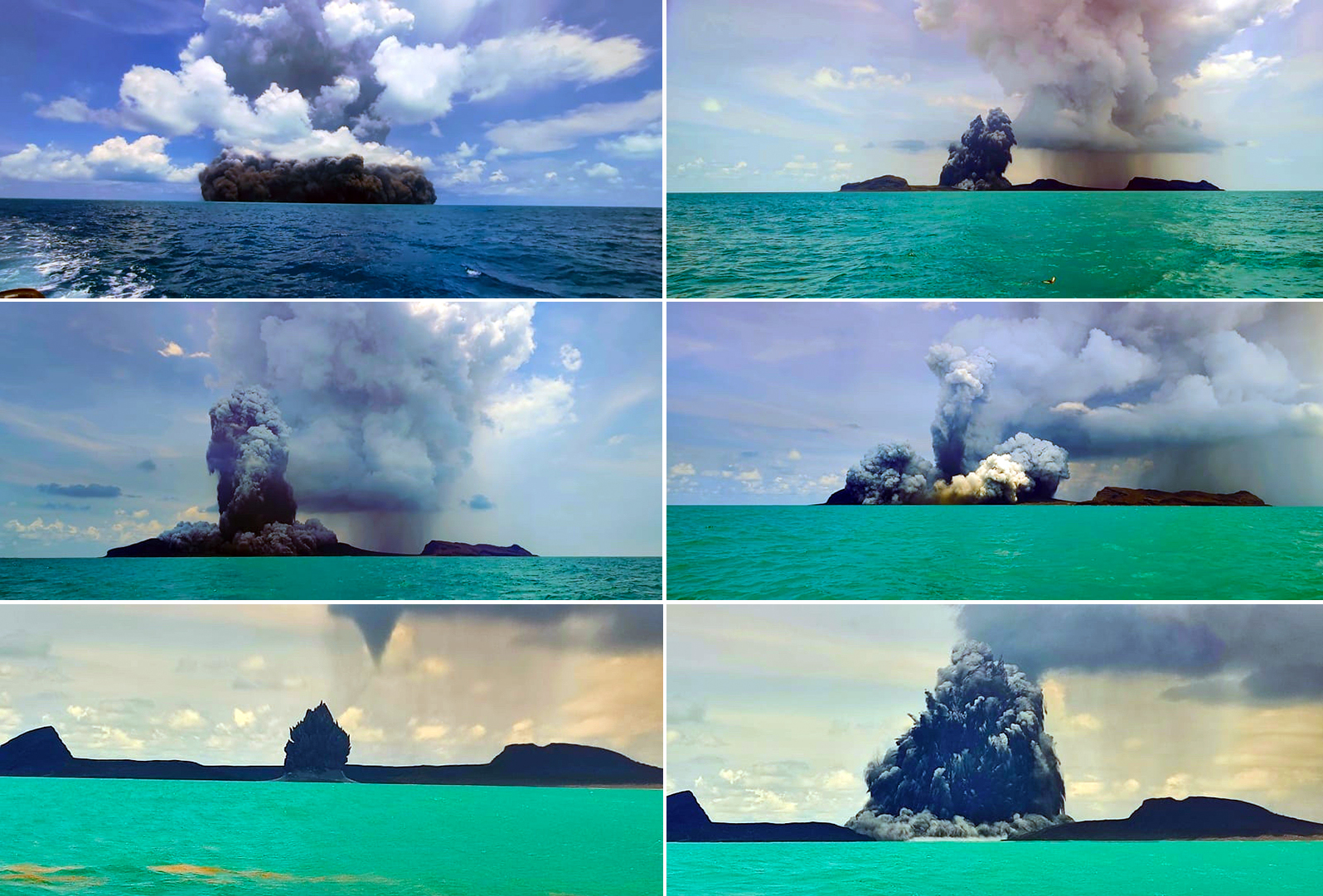 |
Figure 36. Passengers on a small South Seas Charters boat witnessed multiple Surtseyan explosions from Hunga Tonga-Hunga Ha’apai on 29 December 2021, with jets of black tephra and dense steam rising up and out from the vent, and ash falling from the drifting plumes. View is looking SE. Courtesy of GP Orbassano, used with permission. |
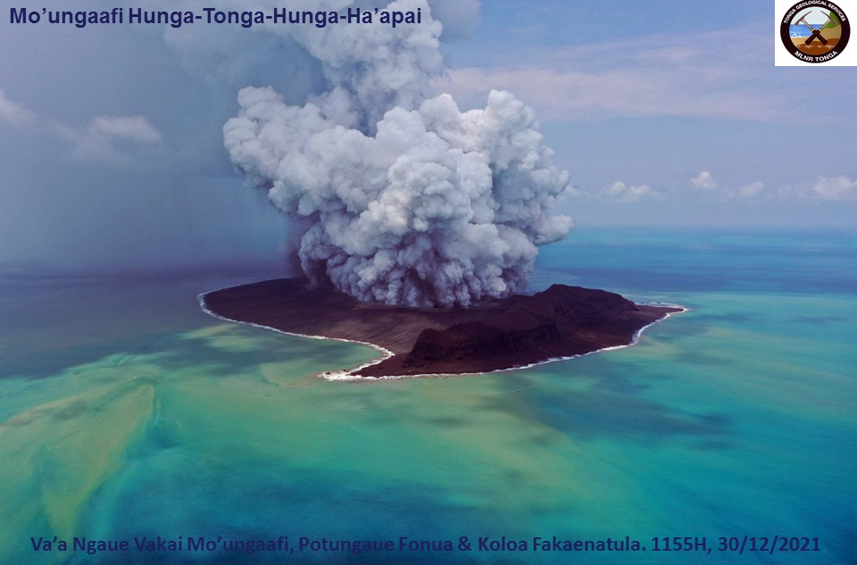 |
Figure 37. Personnel from the Tonga Geological Services and Tonga Navy used a UAV to video multiple intermittent Surtseyan explosions of tephra, steam, and gas at Hunga Tonga-Hunga Ha’apai on 30 December 2021. Courtesy of Tonga Geological Services. |
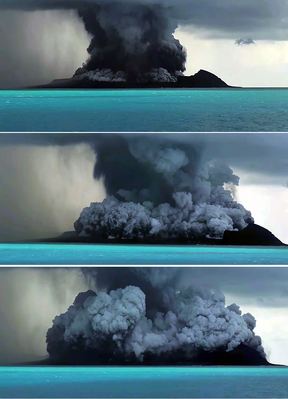 |
Figure 38. Tongan Geological Services scientists witnessed multiple Surtseyan explosions at Hunga Tonga-Hunga Ha’apai on 30 December 2021. These three screen shots from their video span about 30 seconds. In the top image, a dense plume of black tephra and steam has just exploded from the vent sending ash and steam into a dense atmospheric cloud; ash is raining down around the island. The following images show a basal surge of steam, gas, and tephra rising up and outward from the vent. Courtesy of Tonga Geological Services. |
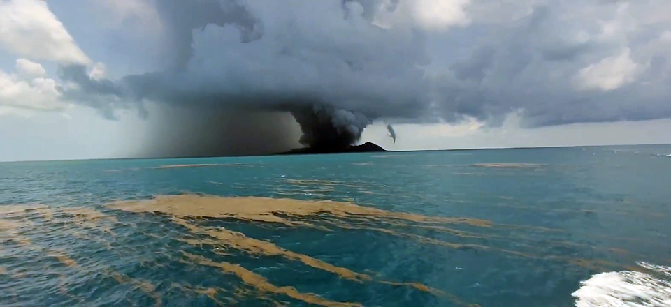 |
Figure 39. Rafts of pumice were visible in the water several kilometers from the erupting Hunga Tonga-Hunga Ha’apai on 30 December 2021. Courtesy of Tonga Geological Services. |
In a public notice released at 0700 on the morning of 31 December, TGS noted that ash had been detected during the prior evening, with the plume drifting N to the W of Ha’apai and Vava’u Islands at altitudes of 4-18 km. Ash was last detected in satellite images 30 km S of Niuafo’ou (550 km N) at 0150 on 31 December. They detected only steam and gas at 0430 later that morning drifting NNE at about 12 km altitude. The following day, 1 January 2022, intermittent gas and steam eruptions continued, but no ash was reported after 1200. Plumes drifted E across the ‘Otu Mu’omu’a Islands of the Ha’apai Group (130 km NE) at an estimated altitude of 12 km. The next morning, 2 January, they drifted ESE across the Tongatapu waters. TGS reported on the morning of 3 January that no ash, steam, or gas emissions had been observed for 24 hours. A small ash plume was detected between 2220 and 2230 that evening at 5-7 km altitude located 5-10 km NE of the volcano. Just after midnight on 4-5 January a minor ash plume was detected at 8 km altitude about 15 km N of the volcano that dissipated after about 30 minutes; this was the last ash emission observed during this series of events.
A substantial sulfur dioxide plume of nearly 9 kilotons was released on 20 December 2021 at the beginning of the eruption; plumes with 6-13 kilotons of SO2 drifted daily over the Pacific Ocean during 22 December-1 January 2022 (figure 40). A large area of pumice rafts around 10 km wide was visible in Sentinel 2 satellite imagery drifting almost 100 km W of the volcano on 2 January 2022 (figure 41). Dark pumice washed up on the northwestern beaches of Tongatapu Island on 5 January (figure 42). A clear satellite image of the island on 7 January 2021 revealed the extent of the growth of Hunga Tonga-Hunga Ha’apai during the eruptive activity of 20 December 2021-5 January 2022 (figure 43). A second subaerial vent had appeared to the E of the original 2015 vent and was surrounded on the E and S by a wide apron of tephra connecting the vent to the older Hunga Tonga Island to the NE.
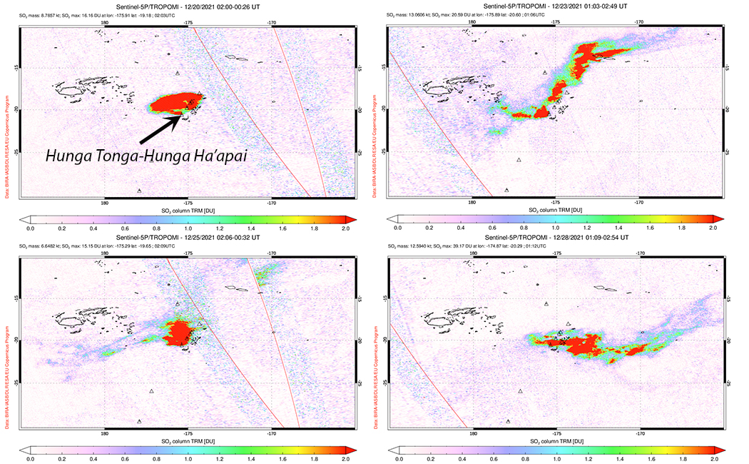 |
Figure 40. A large plume of SO2 that measured about 9 kilotons was released from Hunga Tonga-Hunga Ha’apai on 20 December 2021 at the start of the eruption. Sulfur dioxide plumes of 6-13 kilotons were released daily during 22 December 2021-1 January 2022. Courtesy of NASA Global Sulfur Dioxide Monitoring Page. |
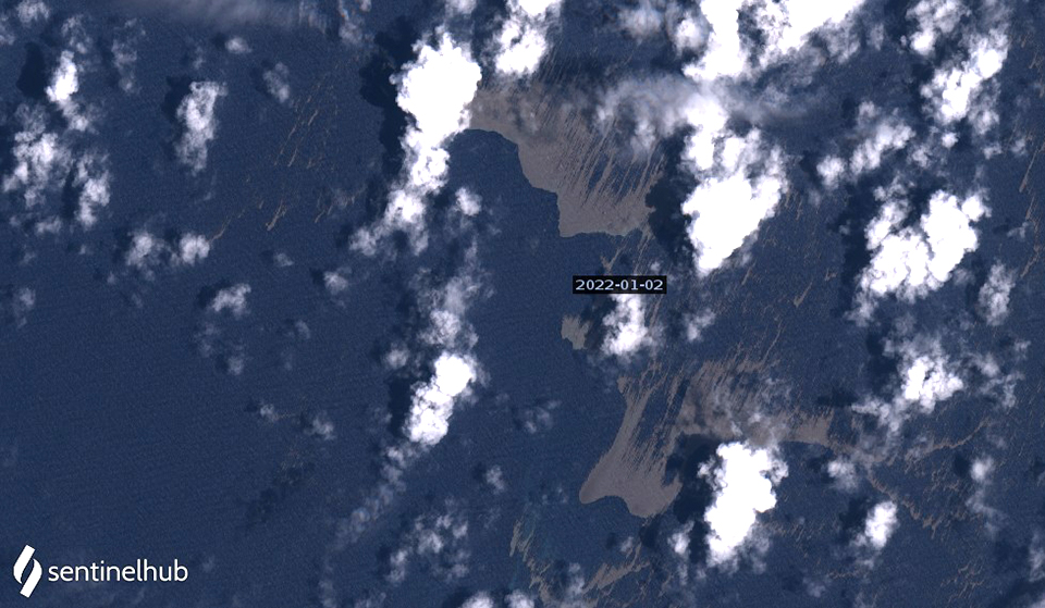 |
Figure 41. Large rafts of pumice from Hunga Tonga-Hunga Ha’apai were visible in Sentinel 2 satellite imagery on 2 January 2022. Each brown area is about 4 km in its widest dimension, and they were located nearly 100 km WSW of the volcano. Image uses Natural color rendering (bands 4, 3, 2). Courtesy of Sentinel Hub Playground. |
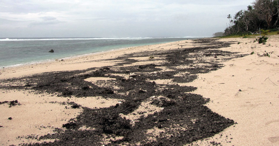 |
Figure 42. Dark pumice, presumed to be from Hunga Tonga-Hunga Ha’apai, washed up on Kanokupolu Beach, 60 km S on the northwestern coast of Tongatapu Island on 5 January 2022. Photo by Shane Egan, courtesy of Matangi Tonga Online. |
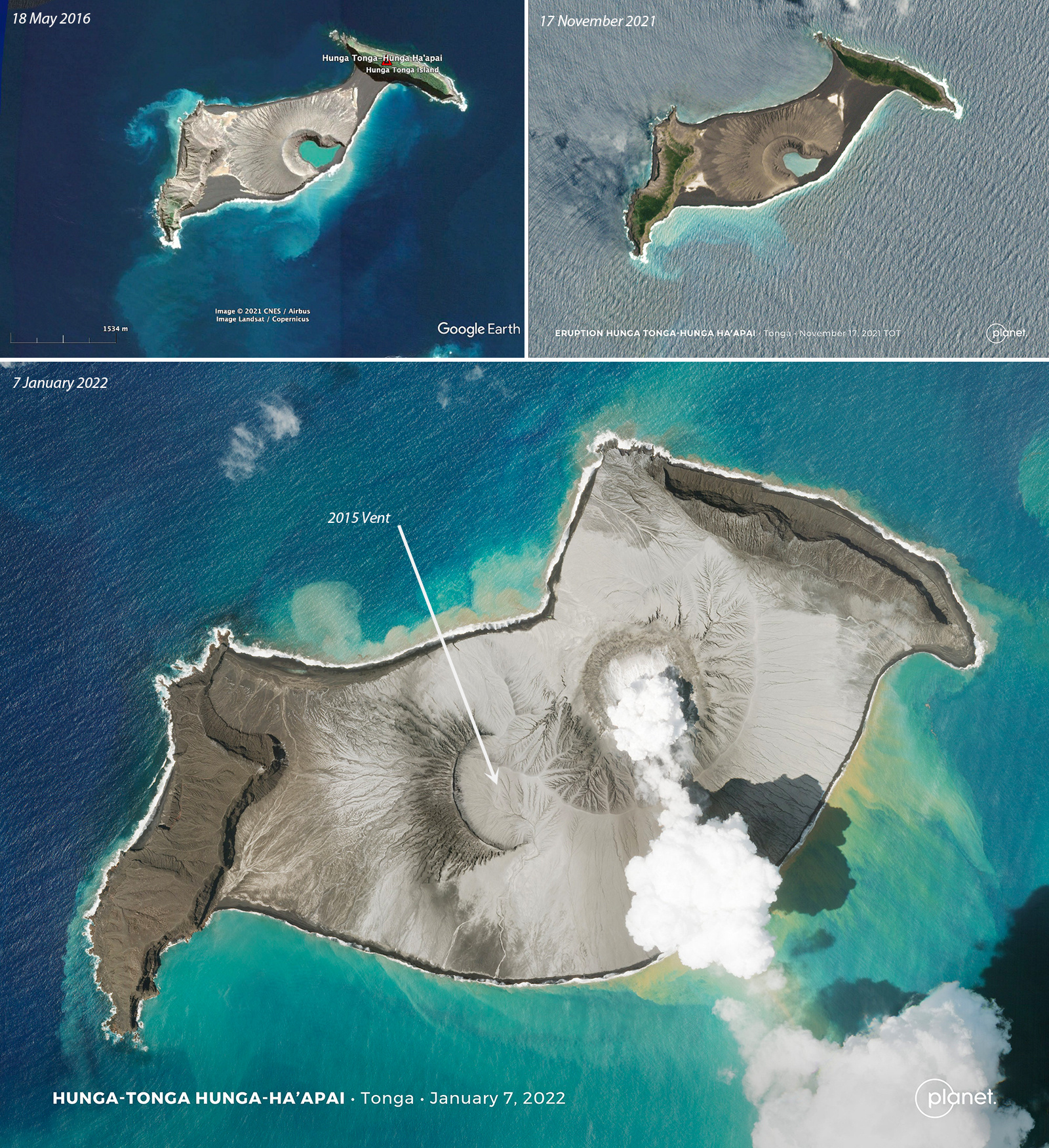 |
Figure 43. Hunga Tonga-Hunga Ha’apai grew significantly during the eruptive activity that occurred between 20 December 2021 and 5 January 2022 as compared with very little change in its shape since 2016. The top images show the island on 18 May 2016 (left) and 17 November 2021 (right) and the bottom image shows the island on 7 January 2022. A new vent grew above sea level to the NE of the 2015 vent and a large apron of tephra connected the vent to the older Hunga Tonga Island to the NE and surrounded it to the S. 18 May 2016 image courtesy of Google Earth, 17 November 2021 and 7 January 2022 images courtesy of Planet.com and Tanya Harrison. |
References:
Cronin S J, Brenna M, Smith I E M, Barker S J, Tost M, Ford M, Tonga’onevai S, Kula T, Vaiomounga R, 2017. New volcanic island unveils explosive past. Eos, 98 (26 June 2017). https://doi.org/10.1029/2017EO076589
Garvin J B, Slayback D A, Ferrini V, Frawley J, Giguere C, Asrar G R, Andersen K, 2018. Monitoring and modeling the rapid evolution of Earth’s newest volcanic island: Hunga Tonga Hunga Ha’apai (Tonga) using high spatial resolution satellite observations . Geophysical Research Letters, 45: 3445-3452. https://doi.org/10.1002/2017GL076621
Brenna M, Cronin S J, Smith I E M, Pontesilli A, Tost M, Barker S, Tonga’onevai S, Kula T, Vaiomounga R, 2022. Post-caldera volcanism reveals shallow priming of an intra-ocean arc andesitic caldera: Hunga volcano, Tonga, SW Pacific. Lithos, 412-413, 106614. https://doi.org/10.1016/j.lithos.2022.106614
Information Contacts: Tonga Geological Services, 51 Vaha'akolo Road, Nuku’alofa, Tonga (URL: https://www.facebook.com/tongageologicalservice); Matangi Tonga Online (URL: https://matangitonga.to/); RNZ Pacific (URL: https://www.rnz.co.nz); Wellington Volcanic Ash Advisory Centre (VAAC), Meteorological Service of New Zealand Ltd (MetService), PO Box 722, Wellington, New Zealand (URL: http://www.metservice.com/vaac/, http://www.ssd.noaa.gov/VAAC/OTH/NZ/messages.html); Google Earth (URL: https://www.google.com/earth/); Planet Labs, Inc. (URL: https://www.planet.com/); Tanya Harrison, Planet Labs, Inc. (URL: https://twitter.com/tanyaofmars/status/1483560804226109444); Scott Bryan, Queensland University of Technology (QUT), Brisbane, QLD 4001, Australia (URL: https://www.qut.edu.au/about/our-people/academic-profiles/scott.bryan); The Pacific Newsroom (URL: https://www.facebook.com/groups/Pacificnewsroom); Simon Proud (https://twitter.com/simon_sat/status/1472852455708889089); Maxar Technologies (URL: https://www.maxar.com/); Murray Ford (URL: https://twitter.com/mfordNZ/status/1473509942090813441); Alakihihifo Vailala (URL: https://twitter.com/alakihihifo/status/1473997579373318147); NASA Global Sulfur Dioxide Monitoring Page, Atmospheric Chemistry and Dynamics Laboratory, NASA Goddard Space Flight Center (NASA/GSFC), 8800 Greenbelt Road, Goddard MD 20771, USA (URL: https://so2.gsfc.nasa.gov/); Sentinel Hub Playground (URL: https://www.sentinel-hub.com/explore/sentinel-playground); GP Orbassano (URL: https://www.facebook.com/gp.tonga/posts/1742471535946154).
Surtseyan explosions with eruption plumes during 14-15 January 2022
The Hunga Tonga-Hunga Ha’apai volcano includes the small islands of Hunga Tonga and Hunga Ha’apai along with shallow reefs along the caldera rim of a much larger submarine edifice in the western South Pacific Ocean (see figure 25; BGVN 47:02), west of the main inhabited islands in the Kingdom of Tonga. It is one of 12 confirmed submarine volcanoes along the Tofua Arc, a segment of the larger Tonga-Kermadec volcanic arc. The Tonga-Kermadec arc formed as a result of subduction of the Pacific Plate beneath the Indo-Australian Plate. The capital city of Tonga, Nuku’alofa, is located 65 km S on the island of Tongatapu. New Zealand lies 2,000 km S, and Australia is over 3,000 km SW.
The first recorded eruption at this site occurred in 1912, followed by an eruption in 1937, and then S of the islands in 1988. In 2009 a short eruption increased the land area at Hunga Ha’apai; around this time the two islands were each about 2 km long (BGVN 34:03). During December 2014 through January 2015 eruptive activity added land between the islands, creating the merged Hunga Tonga-Hunga Ha’apai island (BGVN 40:01). Major Surtseyan explosions and eruption plumes were detected beginning in late December 2021, which initially reshaped the central part of the combined island (BGVN 47:02) before stronger activity on 14 January 2022 removed most of the 2014-2015 material. The next day, 15 January, an even larger eruption generated a plume that reached at least 20 km altitude, caused a tsunami across the Pacific Ocean, and triggered shock waves through the atmosphere; only small remnant of the islands remained visible above the ocean surface. This report will update details of the large 14-15 January 2022 events using information primarily from the Tonga Geological Services (TGS), Tongan and New Zealand news outlets, the Wellington and Darwin Volcanic Ash Advisory Centers (VAAC), and various satellite data.
Activity during 1-13 January 2022. According to observations of satellite images, little eruptive activity was detected during 1-2 January. On 2 January a Sentinel-2 natural color image showed green-yellow discolored water in the area west of the volcano, accompanied by white gas-and-steam emissions drifting NE on the SW end of the westernmost island (figure 44). Pumice rafts roughly 10 m wide were also visible in Sentinel-2 satellite imagery, drifting about 100 km W of the volcano on 2 January (see figure 41; BGVN 47:02). The surface area of the island had grown from approximately 2 km2 on 10 December 2021 to 3.6 km2 on 2 January 2022. The vent was estimated to be at 90 m elevation and the base of the active cone had grown from 500 to 1,700 m wide.
|
Figure 44. A Sentinel-2 satellite image showing green-yellow discolored water surrounding the area to the W of Hunga Tonga-Hunga Ha’apai captured on 2 January 2022. Some white gas-and-steam emissions are visible rising from the SW end of the island. Image uses “Natural color” rendering (bands 4, 3, 2). Courtesy of Sentinel Hub Playground. |
A small ash plume was detected during 2220-2230 on 3 January that rose to 6-7 km altitude and drifted 5-10 km NE, according to TGS (figure 45). At 2230 the plume decreased in altitude to 5 km. During 3-4 January a cyclone passed through the area, obscuring views of the volcano. A minor ash plume was again detected between 0000 and 0010 on 5 January, which rose to 8 km altitude and drifted 15 km NE; by 0010 the plume had drifted 18 km ENE. Some pumice had washed up on the northwestern beaches of Tongatapu Island on 5 January (see figure 42; BGVN 47:02) and a sulfurous odor was reported on the Nuku’alofa waterfront on 6 January.
|
Figure 45. HIMAWARI-8 AHI satellite images captured a small ash plume rising 5-10 km NE from Hunga Tonga-Hunga Ha’apai (purple box) at 2220 (left) and 2230 (right) on 3 January 2022. At 2220 the plume rose to 6-7 km altitude and by 2230, it had decreased to 5 km, based on the color scale on the bottom right of each image. Courtesy of Tonga Geological Services. |
Activity during 14 January 2022. A sub-aerial eruption that began at 0420 on 14 January generated a mushroom-shaped eruption plume consisting of gas-and-steam and ash which was 5 km wide at the base and rose to the stratosphere, 18-20 km altitude, according to TGS (figure 46). The plume expanded radially to 240-260 km diameter and extended over Tongatapu (70 km S), ‘Eua (106 km SSE), Ha’apai (130 km NE), and Vava’u (270 km NNE). Geologists on a boat observed Surtseyan pulses ejecting dark, dense material into the air and pyroclastic flows expanding over the ocean around 1700-1830 (figure 47). The activity removed approximately the middle third of the island that had been enlarged over the previous weeks, according to analysis of a Planet Labs satellite image acquired at 1525 on 15 January (figure 48).
|
Figure 46. A massive eruption plume rising above Hunga Tonga-Hunga Ha’apai was captured by the GOES-17 satellite (NOAA) at 0640 on 14 January 2022. The plume rose above 16 km altitude and expanded radially at the top to 240-260 km in diameter. Tongan islands are outlined in blue. Courtesy of CIMSS and SSEC. |
|
Figure 47. Successive photos of the explosion at Hunga Tonga-Hunga Ha’apai taken at 1712 (top), 1727 (middle), and 1816 (bottom) on 14 January 2022. The view at 1712 is towards the NE with the volcano in the foreground. The photo at 1727 looks E with Hunga Ha’apai in the foreground and Hunga Tonga on the far right. In the 1816 image the view is to the N with Hunga Ha’apai to the left of the plume. The plume measures 5 km wide at the base and rises to 18-20 km altitude in each of these photos. Courtesy of Tonga Geological Services. |
|
Figure 48. The center section of Hunga Tonga-Hunga Ha’apai became submerged as a result of the large explosion on 14 January 2022. It is surrounded by green-yellow discolored water and gray-brown pumice rafts. Image courtesy of Tanya Harrison, Planet Labs. |
A national tsunami warning was issued at 1112 due to abnormal swirling water off the coast of Nuku’alofa, according to a Matangitonga news article. The Tonga Meteorological Services (TMS) also issued tsunami warnings for areas including ‘otu Mu’omu’a in Ha’apai (Nomuka, Mango, Fonoifua), ‘Atataa, ‘Eueiki, and Tongatapu mo ‘Eua. Fluctuating tsunami waves were recorded off the coast of Tongatapu throughout the day; waves reached 200 m inland and rose as high as 15 m in elevation on the Good Samaritan Beach, according to TGS. The highest tsunami wave was recorded around 1800, measuring 30 cm, according to the Nuku’alofa tidal gauge.
The eruption on 14 January continued for more than 12 hours, with the plume reaching 20 km altitude, based on data from HIMAWARI-8 AHI satellite imagery captured between 1410 and 2330. Ashfall was reported on the Mango and Fonoi (75 km ENE) islands of Ha’apai. The eruption plume also contained an estimated sulfur dioxide mass of 0.05 Tg (50 kilotons), based on satellite data. As a result, the smell of sulfur was reported over Tongatapu, Ha’apai, and ‘Eua. Ashfall was reported on many islands, including Fonoi and Mango. All domestic flights in Tonga were canceled on 15 January. By 2230 the altitude of the plume had decreased to 18 km. The Global Lightning Detection Network (GLD360) ground-based network detected 191,309 lightning events from 0334 on 14 January through 0134 on 15 January, or up to 30,000 events per hour.
Activity during 15 January 2022. The eruption was intermittent during 0043 through 0604, according to the Wellington VAAC; plumes rose to 14 km altitude. The Nuku’alofa tidal gauge recorded waves less than 10 cm high through 1000 on 15 January, causing the National Tsunami Warning Centre to cancel the tsunami marine warning for Tongatapu, Ha’apai, and southern Tonga. Based on observations from satellite images, an ash plume rising to 14 km altitude was detected at 0720 on 15 January that drifted downwind to the E from the volcano due to an eruption that lasted 10-15 minutes.
A larger submarine eruption began at 1700 on 15 January from vents just below the surface of the ocean, generating an eruption plume of gas, steam, and some ash. A report from the Wellington VAAC stated that the plume had risen to 15.2 km altitude by 1918; the top of the plume was at least 600 km in diameter by 1903 as seen in satellite images (figure 49). According to news reports and social media posts, residents in Nuku’alofa heard multiple loud booms and saw a large expanding eruption plume that eventually covered all the Tongan islands. The eruptive activity lasted eight minutes.
|
Figure 49. HIMAWARI-8 satellite image showing the significant eruption plume that rose from Hunga Tonga Hunga Ha’apai taken at 1800 (local time) on 15 January 2022. The top of the plume measured at least 600 km in diameter and rose to at least 20 km altitude, possibly higher. Tongan islands are outlined in blue. Courtesy of CIMSS. |
Ashfall eventually measuring several centimeters thick started around 1800 on 15 January and lasted about 10 hours (figure 50), which also affected water tanks and some residents reported having difficulty from breathing the ash in the air. The eruption caused a communications black out across the country, which included damaging the underwater fiber-optic cable providing access to the internet and damage to satellite terminals due to being covered in ash.
|
Figure 50. Drone image of the tsunami aftermath from the Hunga Tonga-Hunga Ha’apai eruption taken on 16 January 2022. Image shows ashfall in Nuku’alofa. Courtesy of Tonga Geological Services. |
During 1719-2300 on 15 January there were almost 400,000 lightning events recorded in the plume by the GLD360 network, with 200,000 of those occurring during 1800-1900. The plume continued to rise to at least 20 km altitude, though other satellite datasets suggested that some of it may have risen as high as 30 km. At 0343 on 16 January the plume was at 19.2 km altitude. Based on volcanic ash advisories issued by the Wellington VAAC and then by the Darwin VAAC, the horizontal extent of the plume grew from 18,000 km2 at 1739 on the 15th to 12 million km2 by 1300 on 19 January. The plume narrowed and lengthened along an E-W axis, moving W over Australia. According to data from the TROPOMI instrument on the Sentinel-5P satellite, a sulfur dioxide plume was detected with a mass of roughly 50 kilotons on 14 January, 420 kilotons that drifted W on 16 January, and 400 kilotons that continued to drift W on 17 January (figure 51).
|
Figure 51. A large sulfur dioxide plume was released from Hunga Tonga-Hunga Ha’apai on 14 January 2022 (top) that measured roughly 50 kilotons. Significant plumes with a mass of roughly 400-420 kilotons continued to be visible on 16 January (middle) and 17 January (bottom) drifted W. Courtesy of NASA Global Sulfur Dioxide Monitoring Page via Simon Carn. |
The explosions produced multiple pressure (shock) waves that rippled through surrounding weather clouds at a rate of 300 m/s, though the pressure wave from the largest explosion propagated across the planet. The sonic boom from this wave was heard at great distances, including within about two hours in New Zealand (2,300 km SW), Samoa, Fiji (500 km NW), Vanuatu, Cook Islands, and Alaska (9,370 km NE km). The pressure wave was also recorded by infrasound and weather instruments worldwide as it circled the Earth, with instruments detecting it again when it arrived from the opposite direction.
Warnings were issued for the N and E coasts of New Zealand’s North Island and the Chatham Islands; multiple boats were destroyed overnight in Tutukaka Marina in Far North (figure 52). According to an RNZ article, more than 120 people had been evacuated from the Far North between 2300 and 0000. Tsunami waves reaching 1.2 m high hit Nuku’alofa during the evening, breaching the shoreline and flooding coastal roads and properties. At Mango Island (75 km ENE), the tsunami waves reached 500 m inland and rose as high as 12 m high, destroying buildings and trees (figure 53). According to the Tongan Navy, tsunami waves that hit Mango Island reached 5-10 m high. According to an official update from the Tongan government on 20 January, tsunami waves reached up to 15 m high, which affected the W coasts of Tongatapu, 'Eua, and Ha'apai Islands and the water depth in the village of Kanokupolu was 1.5 m.
|
Figure 52. Photos of boats that were damaged by strong tsunami waves during the night of 15 January 2022 as a result of the Hunga Tonga-Hunga Ha’apai eruption and possibly Cyclone Cody at Tutukaka Marina in Far North. Photo by Sam Olley. Courtesy of Radio New Zealand. |
|
Figure 53. Video footage of Mango Island (75 km NE) showing the damage caused by the tsunami waves generated by Hunga Tonga-Hunga Ha’apai from the eruption on 15 January 2022 coupled with an acoustic wave that permeated the atmosphere. The resulting wave measured 12 m high and moved as far as 500 m inland. Traces of the waves can be observed based on the dark brown rings surrounding the coast on the sand. Ashfall lasting 10 hours was also reported after 1800 on the 15th. Footage was captured on 20 January 2022. Video captured by Nikolasi Heni. Courtesy of Tonga Geological Services. |
In Japan, around 230,000 people were advised to evacuate across eight prefectures due to the tsunami risk. The resulting waves were recorded in the Kominato district of Amami-Oshima Island in Kagoshima Prefecture at 2355. The waves reached 80 cm in Japan, disrupting train services, flights, and damaging harbors and boats. In Anchorage, Alaska, the US National Weather Service reported maximum waves heights of 20-100 cm on Alaskan coastlines and along the British Columbia coast, waves were 16-29 cm. By the morning of 16 January, the tsunami warning had been extended to the W coast of South Island. Reports indicated that the villages of Sopu, Kolomotua, Kolofo'ou, Ma'ufanga, Patangata were also affected by the tsunami, especially areas near Vuna Road.
Activity during 16-31 January 2022. No new eruptive events were detected after the large explosive eruption on 15 January. A satellite image taken on 18 January showed that most of the previously combined island had been destroyed, leaving only a small part of the NE island of Hunga Tonga (200 m long) and the SW island of Hunga Ha’apai (700 m long) visible above the ocean surface (figure 54). Pumice rafts were visible to the SE of Hunga Ha’apai. The Aviation Color Code was lowered to Green on 19 January. According to the Darwin VAAC, the plume continued to drift W at altitudes between 12.8 and 19.2 km during 19-22 January; the ash was diffuse and difficult to distinguish from meteorological clouds, though the sulfur dioxide signal was stronger. The leading edge of the plume reached the E coast of Africa on 22 January, but by 2150 (local time) the Darwin VAAC noted that ash was no longer detectable.
|
Figure 54. Following the major eruption on 15 January 2022, this image taken on 18 January shows that most of the previous combined island had been destroyed, leaving only small remnants of the NE island of Hunga Tonga (200 m long) and the SW island of Hunga Ha’apai (700 m long) visible above the ocean surface. A few days after the eruptive activity, pumice rafts were still visible in the area. Images courtesy of Tanya Harrison, Planet Labs. |
The Tongan Ministry of Foreign Affairs and Trade confirmed three deaths and multiple people injured following the explosion and tsunami on 15 January. Aerial surveillance images showed that buildings and villages had washed away or been badly damaged, roofs were covered with ash, trees were uprooted, vegetation was brown and damaged, and modified coastlines contained sediment-laden waters. All the houses on Mango Island were destroyed due to the tsunami waves; a few temporary tarpaulin shelters were still visible. Only two houses remained on Fonoifua, and extensive damage was also reported on Nomuka Island (figure 55). Evacuations began on 19 January, which included people on the islands of Mango, Atata, and Fonoifua; about 150 people were evacuated to other islands. About 89 people remained in evacuation shelters on the island of ‘Eua. According to the Tongan government, parts of the W side of Tongatapu, including Kanokupolu, were evacuated after dozens of houses were damaged (figure 55), and in the central district many houses were damaged in Kolomotu'a and on the island of 'Eua. Numerous buildings were reported gone on Atata Island. Roughly 62 survivors were evacuated from Mango Island to Tongatapu on 22 January via a Navy patrol boat. According to a news article from Radio New Zealand, two deaths were reported from a beach in Peru (over 10,000 km) due to high tsunami waves.
|
Figure 55. Drone images of Nomuka Island (top) and Kanokupolu Village (bottom) showing the damage caused by the Hunga Tonga-Hunga Ha’apai eruption taken on 16 January 2022. Image on the bottom shows the remnants of the Vakaloa Resort. Footage of Nomuka Island was recorded by Nikolasi Heni. Courtesy of Tonga Geological Services. |
According to a media release from the Government of Tonga on 21 January, all the islands were affected by ashfall and tsunami waves. A relief flight from New Zealand brought telecommunication equipment and a repair vessel was sent to repair the damaged seafloor fiber-optic cable; domestic flights remained suspended. Dozens of Mw 4.5-5 earthquakes were detected in the vicinity of the volcano after the eruption, at least through 24 January, though the type of earthquake signal was unknown.
Information Contacts: Tonga Geological Services, 51 Vaha'akolo Road, Nuku’alofa, Tonga (URL: https://www.facebook.com/tongageologicalservice); Matangi Tonga Online, PO Box 958, Nuku‘alofa, Tonga (URL: https://matangitonga.to/); RNZ (Radio New Zealand) Pacific, PO Box 123, Wellington 6140, New Zealand (URL: https://www.rnz.co.nz); Darwin Volcanic Ash Advisory Centre (VAAC), Bureau of Meteorology, Northern Territory Regional Office, PO Box 40050, Casuarina, NT 0811, Australia (URL: http://www.bom.gov.au/info/vaac/); Wellington Volcanic Ash Advisory Centre (VAAC), Meteorological Service of New Zealand Ltd (MetService), PO Box 722, Wellington, New Zealand (URL: http://www.metservice.com/vaac/, http://www.ssd.noaa.gov/VAAC/OTH/NZ/messages.html); Planet Labs, Inc. (URL: https://www.planet.com/); NASA Global Sulfur Dioxide Monitoring Page, Atmospheric Chemistry and Dynamics Laboratory, NASA Goddard Space Flight Center (NASA/GSFC), 8800 Greenbelt Road, Goddard, MD 20771, USA (URL: https://so2.gsfc.nasa.gov/); Cooperative Institute for Meteorological Satellite Studies, University of Wisconsin-Madison, Space Science and Engineering Center, 1225 West Dayton Street, Madison, WI 53706, USA (URL: http://tropic.ssec.wisc.edu/); Sentinel Hub Playground (URL: https://www.sentinel-hub.com/explore/sentinel-playground); 1 News, New Zealand (URL: https://www.1news.co.nz/); Tanya Harrison, Planet Labs, Inc. (URL: https://twitter.com/tanyaofmars); Chris Vagasky, National Lightning Safety Council (URL: https://twitter.com/COweatherman); Simon Carn, Geological and Mining Engineering and Sciences, Michigan Technological University, 1400 Townsend Drive, Houghton, MI 49931, USA (URL: http://www.volcarno.com/, Twitter: @simoncarn).
|
|
||||||||||||||||||||||||||
There is data available for 7 confirmed eruptive periods.
2021 Dec 20 - 2022 Jan 15 Confirmed Eruption (Submarine) VEI: 5
| Episode 1 | Eruption (Submarine) | ||||||||||||||||||||||||||||||||||||||||||||
|---|---|---|---|---|---|---|---|---|---|---|---|---|---|---|---|---|---|---|---|---|---|---|---|---|---|---|---|---|---|---|---|---|---|---|---|---|---|---|---|---|---|---|---|---|
| 2021 Dec 20 - 2022 Jan 15 | Evidence from Observations: Reported | |||||||||||||||||||||||||||||||||||||||||||
|
List of 7 Events for Episode 1
|
||||||||||||||||||||||||||||||||||||||||||||
2014 Dec 19 - 2015 Jan 23 ± 3 days Confirmed Eruption (Submarine) VEI: 3
| Episode 1 | Eruption (Submarine) | about 1 km SW of Hunga Tonga and 1 km E of Hunga Ha'apai islands | ||||||||||||||||||||||||||||||||||||||||||||||||||||||||||||||||||||||||||||||||||||||||||||||||||||||||||||||||||||||||||||||||||||||||||||||||||||
|---|---|---|---|---|---|---|---|---|---|---|---|---|---|---|---|---|---|---|---|---|---|---|---|---|---|---|---|---|---|---|---|---|---|---|---|---|---|---|---|---|---|---|---|---|---|---|---|---|---|---|---|---|---|---|---|---|---|---|---|---|---|---|---|---|---|---|---|---|---|---|---|---|---|---|---|---|---|---|---|---|---|---|---|---|---|---|---|---|---|---|---|---|---|---|---|---|---|---|---|---|---|---|---|---|---|---|---|---|---|---|---|---|---|---|---|---|---|---|---|---|---|---|---|---|---|---|---|---|---|---|---|---|---|---|---|---|---|---|---|---|---|---|---|---|---|---|---|---|---|
| 2014 Dec 19 - 2015 Jan 23 ± 3 days | Evidence from Observations: Reported | ||||||||||||||||||||||||||||||||||||||||||||||||||||||||||||||||||||||||||||||||||||||||||||||||||||||||||||||||||||||||||||||||||||||||||||||||||||
|
List of 28 Events for Episode 1 at about 1 km SW of Hunga Tonga and 1 km E of Hunga Ha'apai islands
|
|||||||||||||||||||||||||||||||||||||||||||||||||||||||||||||||||||||||||||||||||||||||||||||||||||||||||||||||||||||||||||||||||||||||||||||||||||||
2009 Mar 17 (?) - 2009 Mar 22 ± 1 days Confirmed Eruption (Submarine) VEI: 2
| Episode 1 | Eruption (Submarine) | Hunga Ha'apai | |||||||||||||||||||||||||||||||||||||||||||
|---|---|---|---|---|---|---|---|---|---|---|---|---|---|---|---|---|---|---|---|---|---|---|---|---|---|---|---|---|---|---|---|---|---|---|---|---|---|---|---|---|---|---|---|---|
| 2009 Mar 17 (?) - 2009 Mar 22 ± 1 days | Evidence from Observations: Reported | |||||||||||||||||||||||||||||||||||||||||||
|
List of 7 Events for Episode 1 at Hunga Ha'apai
|
||||||||||||||||||||||||||||||||||||||||||||
1988 Jun 1 - 1988 Jun 3 (on or after) Confirmed Eruption (Submarine) VEI: 0
| Episode 1 | Eruption (Submarine) | 1 km SSE of Hunga Ha'apai | |||||||||||||||||||||||
|---|---|---|---|---|---|---|---|---|---|---|---|---|---|---|---|---|---|---|---|---|---|---|---|---|
| 1988 Jun 1 - 1988 Jun 3 (on or after) | Evidence from Observations: Reported | |||||||||||||||||||||||
|
List of 3 Events for Episode 1 at 1 km SSE of Hunga Ha'apai
|
||||||||||||||||||||||||
1937 Confirmed Eruption (Explosive / Effusive) VEI: 2
| Episode 1 | Eruption (Explosive / Effusive) | |||||||||||||||||||
|---|---|---|---|---|---|---|---|---|---|---|---|---|---|---|---|---|---|---|---|
| 1937 - Unknown | Evidence from Observations: Reported | ||||||||||||||||||
|
List of 2 Events for Episode 1
|
|||||||||||||||||||
1912 Apr 29 Confirmed Eruption (Explosive / Effusive) VEI: 2
| Episode 1 | Eruption (Explosive / Effusive) | |||||||||||||||||||||||||||||
|---|---|---|---|---|---|---|---|---|---|---|---|---|---|---|---|---|---|---|---|---|---|---|---|---|---|---|---|---|---|
| 1912 Apr 29 - Unknown | Evidence from Observations: Reported | ||||||||||||||||||||||||||||
|
List of 4 Events for Episode 1
|
|||||||||||||||||||||||||||||
1110 ± 70 years Confirmed Eruption (Explosive / Effusive)
| Episode 1 | Eruption (Explosive / Effusive) | ||||||||||||||
|---|---|---|---|---|---|---|---|---|---|---|---|---|---|---|
| 1110 ± 70 years - Unknown | Evidence from Isotopic: 14C (calibrated) | |||||||||||||
|
List of 1 Events for Episode 1
|
||||||||||||||
The Global Volcanism Program has no synonyms or subfeatures listed for Hunga Tonga-Hunga Ha'apai.
There are no samples for Hunga Tonga-Hunga Ha'apai in the Smithsonian's NMNH Department of Mineral Sciences Rock and Ore collection.
| Copernicus Browser | The Copernicus Browser replaced the Sentinel Hub Playground browser in 2023, to provide access to Earth observation archives from the Copernicus Data Space Ecosystem, the main distribution platform for data from the EU Copernicus missions. |
| MIROVA | Middle InfraRed Observation of Volcanic Activity (MIROVA) is a near real time volcanic hot-spot detection system based on the analysis of MODIS (Moderate Resolution Imaging Spectroradiometer) data. In particular, MIROVA uses the Middle InfraRed Radiation (MIR), measured over target volcanoes, in order to detect, locate and measure the heat radiation sourced from volcanic activity. |
| MODVOLC Thermal Alerts | Using infrared satellite Moderate Resolution Imaging Spectroradiometer (MODIS) data, scientists at the Hawai'i Institute of Geophysics and Planetology, University of Hawai'i, developed an automated system called MODVOLC to map thermal hot-spots in near real time. For each MODIS image, the algorithm automatically scans each 1 km pixel within it to check for high-temperature hot-spots. When one is found the date, time, location, and intensity are recorded. MODIS looks at every square km of the Earth every 48 hours, once during the day and once during the night, and the presence of two MODIS sensors in space allows at least four hot-spot observations every two days. Each day updated global maps are compiled to display the locations of all hot spots detected in the previous 24 hours. There is a drop-down list with volcano names which allow users to 'zoom-in' and examine the distribution of hot-spots at a variety of spatial scales. |
|
WOVOdat
Single Volcano View Temporal Evolution of Unrest Side by Side Volcanoes |
WOVOdat is a database of volcanic unrest; instrumentally and visually recorded changes in seismicity, ground deformation, gas emission, and other parameters from their normal baselines. It is sponsored by the World Organization of Volcano Observatories (WOVO) and presently hosted at the Earth Observatory of Singapore.
GVMID Data on Volcano Monitoring Infrastructure The Global Volcano Monitoring Infrastructure Database GVMID, is aimed at documenting and improving capabilities of volcano monitoring from the ground and space. GVMID should provide a snapshot and baseline view of the techniques and instrumentation that are in place at various volcanoes, which can be use by volcano observatories as reference to setup new monitoring system or improving networks at a specific volcano. These data will allow identification of what monitoring gaps exist, which can be then targeted by remote sensing infrastructure and future instrument deployments. |
| Volcanic Hazard Maps | The IAVCEI Commission on Volcanic Hazards and Risk has a Volcanic Hazard Maps database designed to serve as a resource for hazard mappers (or other interested parties) to explore how common issues in hazard map development have been addressed at different volcanoes, in different countries, for different hazards, and for different intended audiences. In addition to the comprehensive, searchable Volcanic Hazard Maps Database, this website contains information about diversity of volcanic hazard maps, illustrated using examples from the database. This site is for educational purposes related to volcanic hazard maps. Hazard maps found on this website should not be used for emergency purposes. For the most recent, official hazard map for a particular volcano, please seek out the proper institutional authorities on the matter. |
| IRIS seismic stations/networks | Incorporated Research Institutions for Seismology (IRIS) Data Services map showing the location of seismic stations from all available networks (permanent or temporary) within a radius of 0.18° (about 20 km at mid-latitudes) from the given location of Hunga Tonga-Hunga Ha'apai. Users can customize a variety of filters and options in the left panel. Note that if there are no stations are known the map will default to show the entire world with a "No data matched request" error notice. |
| UNAVCO GPS/GNSS stations | Geodetic Data Services map from UNAVCO showing the location of GPS/GNSS stations from all available networks (permanent or temporary) within a radius of 20 km from the given location of Hunga Tonga-Hunga Ha'apai. Users can customize the data search based on station or network names, location, and time window. Requires Adobe Flash Player. |
| DECADE Data | The DECADE portal, still in the developmental stage, serves as an example of the proposed interoperability between The Smithsonian Institution's Global Volcanism Program, the Mapping Gas Emissions (MaGa) Database, and the EarthChem Geochemical Portal. The Deep Earth Carbon Degassing (DECADE) initiative seeks to use new and established technologies to determine accurate global fluxes of volcanic CO2 to the atmosphere, but installing CO2 monitoring networks on 20 of the world's 150 most actively degassing volcanoes. The group uses related laboratory-based studies (direct gas sampling and analysis, melt inclusions) to provide new data for direct degassing of deep earth carbon to the atmosphere. |
| Large Eruptions of Hunga Tonga-Hunga Ha'apai | Information about large Quaternary eruptions (VEI >= 4) is cataloged in the Large Magnitude Explosive Volcanic Eruptions (LaMEVE) database of the Volcano Global Risk Identification and Analysis Project (VOGRIPA). |
| EarthChem | EarthChem develops and maintains databases, software, and services that support the preservation, discovery, access and analysis of geochemical data, and facilitate their integration with the broad array of other available earth science parameters. EarthChem is operated by a joint team of disciplinary scientists, data scientists, data managers and information technology developers who are part of the NSF-funded data facility Integrated Earth Data Applications (IEDA). IEDA is a collaborative effort of EarthChem and the Marine Geoscience Data System (MGDS). |


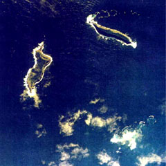 The small islands of Hunga Tonga (upper right) and Hunga Ha'apai (left) are the peaks a large seamount located about 30 km SSE of Falcon Island. The two islands are about 2 km long. They have inward-facing cliffs that represent the W and N remnants of the rim of a largely-submarine caldera lying E and S of the islands. A shoal is visible 3.2 km SE of Hunga Ha'apai and 3 km south of Hunga Tonga and marks the most prominent historically active vent.