
A thermal anomaly extending from the summit of Tinakula down the W flank to the coast was identified in satellite images on 11 March. Images acquired on 6 and 16 March were cloudy or mostly cloudy.
Source: Copernicus
Continued lava flows and thermal activity during June through November 2023
Tinakula is a remote 3.5 km-wide island in the Solomon Islands, located 640 km ESE of the capital, Honiara. The current eruption period began in December 2018 and has more recently been characterized by intermittent lava flows and thermal activity (BGVN 48:06). This report covers similar activity during June through November 2023 using satellite data.
During clear weather days (20 July, 23 September, 23 October, and 12 November), infrared satellite imagery showed lava flows that mainly affected the W side of the island and were sometimes accompanied by gas-and-steam emissions (figure 54). The flow appeared more intense during July and September compared to October and November. According to the MODVOLC thermal alerts, there were a total of eight anomalies detected on 19 and 21 July, 28 and 30 October, and 16 November. Infrared MODIS satellite data processed by MIROVA (Middle InfraRed Observation of Volcanic Activity) detected a small cluster of thermal activity occurring during late July, followed by two anomalies during August, two during September, five during October, and five during November (figure 55).
Information Contacts: MIROVA (Middle InfraRed Observation of Volcanic Activity), a collaborative project between the Universities of Turin and Florence (Italy) supported by the Centre for Volcanic Risk of the Italian Civil Protection Department (URL: http://www.mirovaweb.it/); Hawai'i Institute of Geophysics and Planetology (HIGP) - MODVOLC Thermal Alerts System, School of Ocean and Earth Science and Technology (SOEST), Univ. of Hawai'i, 2525 Correa Road, Honolulu, HI 96822, USA (URL: http://modis.higp.hawaii.edu/); Copernicus Browser, Copernicus Data Space Ecosystem, European Space Agency (URL: https://dataspace.copernicus.eu/browser/).
2024: March
2021: January
2017: October
2012: February
A thermal anomaly extending from the summit of Tinakula down the W flank to the coast was identified in satellite images on 11 March. Images acquired on 6 and 16 March were cloudy or mostly cloudy.
Source: Copernicus
Thermal anomalies over Tinakula’s summit and on the WNW flank were periodically visible in satellite images during 17 December 2020-21 January 2021. Weather clouds often obscured views.
Source: Sentinel Hub
Based on satellite data and information from ground-based observers, the Wellington VAAC reported that during 25 October and the early part of 26 October a low-level eruption at Tinakula was ongoing. Ash emission rose 2.1 km (7,000 ft) a.s.l. and drifted S and SE. A news article from 1 November noted that significant ashfall had covered crops, and the water supplies for an estimated 11,500 people had been contaminated.
Sources: Wellington Volcanic Ash Advisory Center (VAAC); Radio New Zealand
Based on satellite data, the Wellington VAAC reported that an eruption at Tinakula began around 0620 on 21 October, producing a sulfur dioxide signature, and an ash plume that rose to an altitude of 4.6 km (15,000 ft) a.s.l. and drifted N. Another eruption at 1040 generated an ash plume that rose significantly higher that the first, to an altitude of 10.7 (35,000 ft) a.s.l. and drifted SE. Later that day ash plumes rose to 6.1 km (20,000 ft) a.s.l. Ash emissions continued through at least 24 October, rising to altitudes of 3-3.7 (10,000-12,000 ft) a.s.l. and drifting E and W on 22 October, 2.4 km (8,000 ft) a.s.l. and drifting S and SE on 23 October, and 1.8 km (6,000 ft) a.s.l. with a SW drift on 24 October. A news article from 24 October stated that water supplies in the Reef Islands had been contaminated with ashfall, and that ashfall was also reported in Fenualoa, and likely in Nupani.
Sources: Wellington Volcanic Ash Advisory Center (VAAC); Radio New Zealand
According to NASA's Earth Observatory, thermal anomalies from Tinakula were detected in satellite data during 13-14 February and a gas plume with possible ash content rose from the volcano on 14 February.
Source: NASA Earth Observatory
Reports are organized chronologically and indexed below by Month/Year (Publication Volume:Number), and include a one-line summary. Click on the index link or scroll down to read the reports.
Activity increases; lava flows from crater and fissure
Card 1297 (27 September 1971) Activity increases; lava flows from crater and fissure
"Tinakula eruption activity increased. Population evacuated, lava pouring from crater and fissure to sea."
Information Contacts: R. Thompson, Geological Survey of the Solomon Islands, Honiara.
Lava flows enter the sea, ash explosions, and strong seismicity; tsunami on 6 September
Card 1300 (05 October 1971) Aerial observations; lava enters the sea
"Excellent aerial photographs of Tinakula were taken of the erupting volcano on 17 September by map-makers of Australia, and the company navigator, David Gadd gave an eyewitness account. From a study of the photographs it can be seen that at the beginning of the present eruption, ash covered the crater area to an estimated depth of 30 feet and drifts of ash can be seen on the flanks extending 200 m from the crater. The ash may have fallen further from the crater on the summit, particularly on the E and SE flanks where the prevailing wind has carried ash to the bush where the trees obscure it. Rigamoto Nakaera, master of the Belama, described the lava as pouring out of a fissure about 1,200 feet up the W wall of the Cirque caused by the landslide. Steam and white smoke appear to come from the crater. This was confirmed by Gadds observations from the air, who described the lava as pouring out of a crack when it opened about 10 feet. About enough lava to fill five dump trucks came out of the crack in each expulsion and the frequency of the expulsions varied from three in three minutes to one in twelve minutes. The lava, when it first emerged from the fissure, was cherry red even in daylight, and it quickly darkened to black as it flowed quickly down the 65° slope towards the sea. Some of the lava had hardened into a crust about 400 feet above the sea at some constriction and could be seen to exhibit boomerang-shaped ridges on the surface. These, however, got broken up and carried down to the sea by more lava.
"A strong smell of the H2S could be smelled in the plane at heights of between 1,800 and 2,500 feet. The sea was discolored for a distance of 500 m offshore and it could be seen to be bubbling violently 25-30 m from the cliff edge where the lava entered the sea. At the time the photographs were taken the lava had built out a buttress to the slope about 60 m wide and 20 m deep. The size of the buttress beneath the sea cannot be estimated, nor can the total volume of the lava expelled, as most of this is beneath the sea. The eruption continues and has increased in severity.
"Since the above report was written the island was observed on 20 September by the Bishop of Melanesia, who reported that the single lava flow pushing out of a fissure in the wall of the collapsed face had been joined by another lava stream flowing from the crater which was stated to be 50-100 yards wide. A telegram received from Santa Cruz, a district administrative station 25 miles from the volcano on 25 September, confirmed that evacuation was complete and that the eruption appeared to be getting more violent. The whole island was obscured by white smoke, and red flames could be seen at night. On 27 September earth tremors were reported to be felt on Santa Cruz and the volcano was still shrouded in smoke. So far we have been unable to get any seismological observer to observe the volcano."
Card 1301 (12 October 1971) Description of initial activity and tsunami on 6 September
"On 6 September [at about 1800], the people of Neo village on Trevanion island heard a low, continuous thundering sound coming from the volcano. At the same time a thick dark cloud poured from its summit until the sea between the volcano and Travanion Island, including the two Neo villages facing it, was engulfed in this low-lying thick dark smoke. The thundering sound and the dark smoke went on for about two hours. At about 2000 there was a sudden burst of a louder sound. Simultaneously, a huge flame shot up from the summit of the volcano. This flame was described as later dividing into two corkscrew-like tongues of fire, one slanted to the E and the other to the W side of the volcano.
There was no panic shown by the people who watched the episode at this stage as the older people assured the younger ones that the volcano used to behave in this manner many years ago and that they should not be alarmed. However, the comforting words did not last very long because about 30 minutes after the flame died down they heard the roaring sound of the breaking waves coming towards their shores. As the night was very bright with the moonlight, they saw that the sea began to recede in an unusual manner. Knowing that a [tsunami] was coming the families began to gather in groups and move to higher ground. Fortunately the sea did not reach the houses and no injuries occurred
Reports are still coming in from the areas affected by the [tsunami]. At Luesalemba one seagull motor and the canoe were damaged or destroyed. Further up, the NE coast was also affected, according to the reports received.
Another flame or fire flared up at about 0300 on 7 September and its subsequent [tsunami] was observed at 0630 traveling NE from the volcano.
There has not been a single aircraft or ship going between Santa Cruz and Honiara since the eruption so we have had to rely on non-specialist information. The most recent report has described a big increase of activity commencing on 1 October approximately, when at night large blocks of lava could be seen ejected from the crater and smoke and ash were rising to over 1,000 feet above the cone. The observers were all 25 miles from the volcano. During the day rain and cloud prevented observation. The latest report (5 October) is that the activity has died down a bit."
Information Contacts:
Card 1300 (05 October 1971) R. Thompson, Geological Survey Department, Honiara, Guadalcanal, B.S.I.P.
Card 1301 (12 October 1971) D. Dawea-taukalo, Sub Station, Graciosa Bay, Santa Cruz, B.S.I.P.; R.B. Thompson, Geological Survey Dept., Honiara, Guadalcanal, B.S.I.P.
Tephra ejection; W flank submarine cone recognized
The following is from the cruise report of the USGS research vessel S.P. Lee, engaged in multichannel seismic profiling in the Vanuatu and Solomon Islands areas. The report was written by H.G. Greene, A. Macfarlane, and other members of the scientific party.
"On 3 June, Tinakula could be seen 'smoking' in the distance, some 25 km away. As the ship approached the island, large billowing clouds of steam were observed emanating from the summit of the volcano. Occasionally a large, billowing, dark gray, ash-laden plume was observed rising to several kilometers above the island without being disturbed by the prevailing SE trade winds, unlike the steam which was rapidly dissipated by those winds. The emanation of the ash appeared to take place at fairly regular intervals, about every 2 hours.
"The Lee passed within 400 m of Tinakula, on a W-E path along the N side of the island, which presented a good vantage point for observing the active vent at the head of the landslide scarp on the NW side of the volcano. As the ship drew abeam of Tinakula, rumbling sounds could be heard from within the active vent, immediately N of the central crater. Boulder-size (football-size) rocks were ejected from the vent, and were still steaming as they rolled and skipped down the steep, N-dipping scree slope and splashed into the sea. At least a dozen of the boulders and much more material of cobble size (65-250 mm in diameter) were seen being thrown from the vent every minute. Much of this debris was accumulating on the scree slope, which is actively infilling the void left by the 1971 landslide.
"Geophysical data collected by the Lee showed that another volcanic cone is present about 90 m beneath the surface of the water some 5 km W of Tinakula. This submarine volcano is a little smaller than Tinakula and in consequence not projecting above the sea surface. It has a very youthful geomorphic profile with sharp steep flanks, and appears from its morphology to be active. This volcano lies on the W flank of Tinakula and could be a vent associated with the same magmatic processes that are building the island today. This volcano or volcanic vent has not been identified before and is not on any bathymetric map."
Tinakula's last reported eruption started 6 September 1971, preceded by a small tsunami at the island. Intermittent explosive activity built a small summit cone, and incandescent blocks rolled down the volcano's flanks into the sea. A slow-moving lava flow extended about 300 m down the NW flank. About 160 people were evacuated from the island. The eruption ended in December 1971.
Information Contacts: A. Macfarlane, Dept of Geology, Mines, and Rural Water Supplies, Vanuatu; H.G. Greene, USGS.
Vapor and ash emissions
On 13 June at 0946 geologists (about 4 km from Tinakula in a boat) observed a vapor and ash cloud rising slowly from the crater. The ash emission was followed about 5 minutes later by whitish vapor, and the eruption cloud drifted slowly toward the W from the crater.
Stopping ~50 m from the breached NW side of the volcano, the geologists observed rising steam, and large boulders that rolled down the flank before splashing into the sea. There was no lava flow.
During the following two hours, no further eruption was observed as the summit was nearly always covered with clouds. A possible site for a telemetering seismometer was selected on the E side of the volcano at Mendana Cone. Local people reported that the volcano has exhibited similar low-level eruptive behavior since 1984.
Information Contacts: D. Tuni, Ministry of Natural Resources, Honiara.
Observers and infrared data indicate eruptive activity since 1989
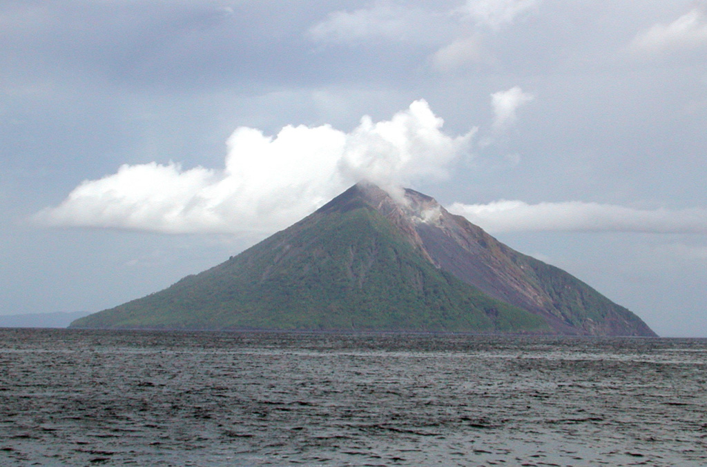
Following an eruption and tsunami from Tinakula (figure 1) during September-December 1971 (CSLP Cards 1297, 1300, and 1301), there were brief reports of large steam plumes and ash plumes in June 1984 (SEAN 09:06) and June 1985 (SEAN 10:06). This report includes observations from a variety of sources. John Seach has provided information about activity during 1989-90 and 1995, as well as some insight into hazards faced by island residents in the area. Passengers on tour expedition ships noted continuing activity in May 1999 and November 2002. MODIS thermal alerts were triggered on three occasions during January-April 2001. In April 2002 excellent observations of eruptive activity were made by scientists on an Australian research vessel.
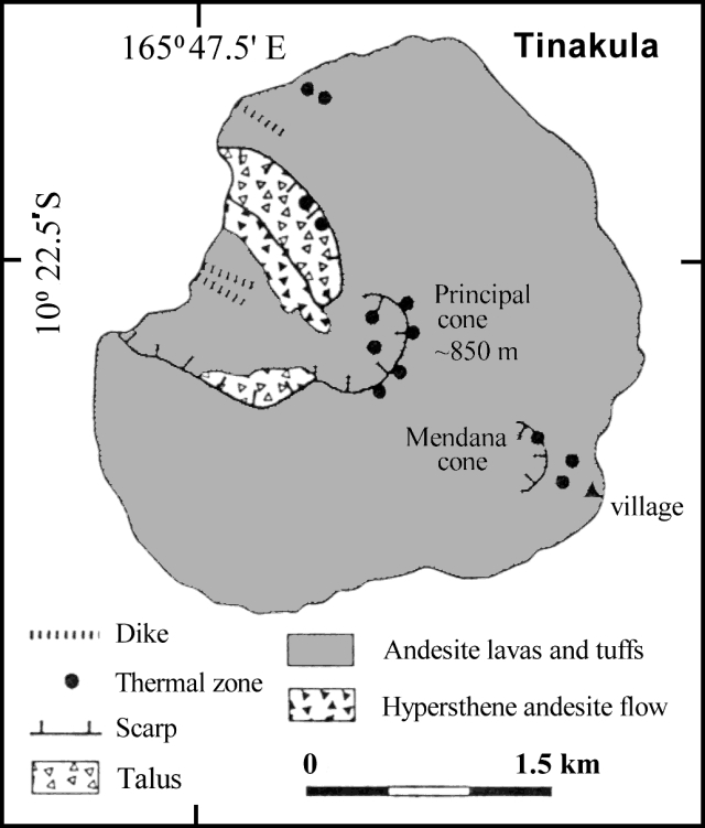 |
Figure 1. Sketch map of Tinakula island based on work and publications by G.W. Hughes (1972) and colleagues and summarized by Eissen and others (1991). |
Observations in 1989-90 and 1995. John Seach observed Tinakula volcano from the Reef Islands (54 km ENE) from August 1989 to February 1990. Typical activity consisted of Vulcanian eruptions and ash emission to 200-400 m above the summit. Eruptions occurred in distinct bursts separated by intervals ranging from minutes to hours. Reports from sailors indicated that lava bombs frequently rolled down to the sea on the NW side of the volcano, and glowing avalanches were observed at night.
Tinakula was approached by motorized canoe on two occasions in 1995, but dangerous seas made landing impossible. Ongoing ash emissions originated from the summit area. The upper slopes of the volcano were bare and exposed to gas emissions. Regions of mass wasting on the flanks were common, and blocks of lava and rubble were found at sea level at various locations around the island. However, some of the lower flanks were covered with thick vegetation. During a Solair flight from Santa Cruz to Honiara in late September 1995, activity was observed at the summit crater with ash emissions drifting several kilometers towards the W.
The island has not been inhabited since the tsunami in 1971, but islanders from the outer Reef Islands occasionally travel to tend gardens on the SE flank. The ocean between Santa Cruz Island and Reef Islands is dangerous, with many currents and high seas regularly capsizing boats. Landing on the island is always dangerous due to prevailing swells and the lack of a suitable beach. The dominant SE trade winds blow ash and gases away from inhabited islands for most of the year, but a large eruption occurring in westerly winds may affect populations in the Reef Islands. Volcanic bombs (5 cm in diameter) of an unknown age located in villages on the Reef Islands (over 50 km away) were reported to have fallen from the sky.
Observations during May 1999. On the morning of 16 May 1999, Matthew Mumford, on a sailing expedition aboard the Akademik Shuleykin, noted as they approached Tinakula that ". . . a cloud of darkness was blown skyward before our bow. As the ash moved across the sky, the contrast of gray against the white pillows of cloud gave a clear indication of how active this volcano continues to be."
MODVOLC Thermal Alerts, 2000-2002. MODIS alerts for Tinakula on 15 January 2001, 6 March 2001, and 16 April 2001 provide objective evidence of continued volcanic activity. The maximum alert ratio was low (-0.75), indicating small-scale activity. The absence of alerts since April 2001 was judged more likely to be because the level of activity has dipped below the -0.8 alert-ratio threshold rather than because of a genuine cessation of activity.
Observations during April 2002. Scientists from the RV Franklin briefly investigated Tinakula during the SOLAVENTS expedition, 26 March-21 April 2002. A vent high up on the W flank was actively expelling gas/steam, which could be heard as a low roar 50 m from shore. Small avalanches down the steep W side were common, and one larger eruption observed from the vessel's bridge lasted about 5 minutes. Small optical transmission anomalies were detected in the water column and are probably turbidity induced-particulate plumes. A weak methane anomaly was also recorded ~2.8 km off the NW coast of Tinakula. The following is based on extracts from the daily narrative section of the cruise report (McConachy and others, 2002).
The Franklin arrived ~3.2 km off the W coast of Tinakula at 0705 on 6 April 2002 (figures 2-5) and in perfect conditions the Zodiac rescue boat was deployed with Able Seaman Graham and scientists Richard Arculus and Donn Tolia to commence water sampling. The zodiac was safely back on deck by 0815. The scientists reported a roaring noise from Tinakula's active crater heard when the boat was 50 m offshore.
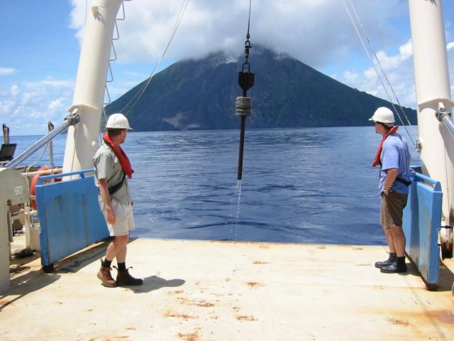 |
Figure 4. Photo of Tinakula taken from the RV Franklin, 6 April 2002. Photographed by Susan Belford; courtesy of CSIRO. |
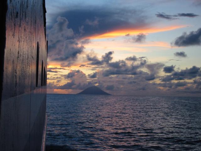 |
Figure 5. Photo of Tinakula in the distance taken from the RV Franklin, 6 April 2002. Photographed by Susan Belford; courtesy of CSIRO. |
From virtually the same location a grab sample collected material from the 1971 eruption at around 950 m depth. An excellent, 75%-full load of exceptionally well-sorted black volcanic sand was recovered, consisting of plagioclase, pyroxene and red-brown fragments; no foraminifera were visible. A CTD-Hydrocast followed at around 0910. During this operation, smoke came from a vent 2/3 way up the summit on the W side of the sector collapse, and minor avalanches came down scree slopes on the N side of the collapse area. A number of light transmission anomalies were observed on the down cast and sampled on the upcast. They are most likely particle plumes following isopycnals (constant density surfaces) sloughing off the main slope.
Observations during November 2002. Passengers on the Zegrahm Expeditions cruise ship Clipper Odyssey observed that Tinakula was "active" on the morning of 18 November 2002, but no description of the activity was provided.
References. McConachy, T.F., Yeats, C.J., Arculus, R.J., Beattie, R., Belford, S., Holden, J., Kim, J., MacDonald, L., Schardt, C., Sestak, S., Stevens, B., and Tolia, D., 2002, SOLAVENTS-2002: Solomons Australia Vents Expedition Aboard the RV Franklin, 26 March-21 April 2002, edited by C.J. Yeats, CSIRO Exploration and Mining Report 1026F, 456 p.
Hughes, G.W., 1972, Geological map of Tinakula: Nendö sheet EOI 1, Soloman Geol. Survey, Honiara.
Eissen, J-P., Blot, C., and Louat, R., 1991, Chronology of the historic volcanic activity of the New Hebrides island arc from 1595 to 1991: Rapports Scientifiques et Technique, Sciences de la Terre, No. 2, ORSTOM, France.
Information Contacts: Timothy F. McConachy, CSIRO Exploration and Mining, PO Box 136, North Ryde, NSW 1670, Australia (URL: http://mnf.csiro.au/); Diego Coppola and David A. Rothery, Department of Earth Sciences, The Open University, Milton Keynes, MK7 6AA, United Kingdom; John Seach, PO Box 16, Chatsworth Island, NSW 2469, Australia (URL: http://www.volcanolive.com/); Jeff and Cynthia Gneiser, Zegrahm & Eco Expeditions, 192 Nickerson Street ##200, Seattle, WA 98109, USA (URL: https://www.zegrahm.com/); Matthew Mumford, Unit 1.02, 26 Kippax Street, Surrey Hills, NSW 2010, Australia.
Additional MODVOLC thermal anomalies identified from January 2001
Inspection of Terra MODIS day- and night-time data (i.e. original data, rather than the thresholded alert data on the MODVOLC website) for 2001 and 2002 identified cloud-free intervals over Tinakula during January-April 2001, August-September 2001, January 2002, and August-September 2002. MODVOLC thermal alerts were previously reported for 15 January, 6 March, and 16 April 2001 (BGVN 28:01). Recognizable thermal anomalies not noted earlier by the automated system appeared at night on 10 January 2001 (alert ratio, -0.804), and during the day on 25 January 2001 (alert ratio, -0.790). This new information reinforces the interpretation that small-scale activity was occurring during the January-April 2001 time period.
Data acquisition and analysis. Reports from Diego Coppola and David A. Rothery provided analyses of MODIS thermal alerts during 2001 and 2002 (using the MODVOLC alert-detection algorithm) extracted from the MODIS Thermal Alerts website (http://modis.hgip.hawaii.edu/) maintained by the University of Hawaii HIGP MODIS Thermal Alerts team (BGVN 28:01). Rothery and Charlotte Saunders provided updates to 31 May 2004. MODVOLC data are now routinely available from the Aqua satellite (equator crossing times 0230 and 1430 local time) in addition to the original Terra satellite (equator crossing times 1030 and 2230 local time).
Information Contacts: David A. Rothery and Charlotte Saunders, Department of Earth Sciences, The Open University, Milton Keynes, MK7 6AA, United Kingdom.
Eruption; increased thermal anomalies during February-April 2006
According to Simon Carn, volcanic activity at Tinakula appears to have begun on 12 February 2006, with a small explosion followed by degassing. He noted some significant SO2 emissions on 14 February, as well as small plumes from Ambrym and Aoba. As of 16 February, there was still a small SO2 signal from Tinakula, but it was no bigger than that from Ambrym or Aoba. Andrew Tupper noted from visible MTSAT (Multi-functional Transport Satellite) images and an Aqua MODIS (Moderate Resolution Imaging Spectroradiometer) screen shot that a plume on 14 February was moving NNE at ~ 10 km/hour and appeared to be not far above summit level; the plume did not register on the IR imagery. MTSAT is a dual-mission satellite for the Japan Ministry of Land, Infrastructure, and Transport and the Japan Meteorological Agency performing an air traffic control and navigation, as well as a meteorological, functions.
On 27 February, Thomas Toba of the Solomon Islands government wrote to Herman Patia of the Rabaul Volcano Observatory, confirming Tinakula activity. Toba contacted authorities from the Temotu Provincial Headquarters who confirmed that there were several small explosions from this volcano around early to middle February 2006.
Satellite thermal-sensor data (using the MODVOLC alert-detection algorithm) revealed a period of thermal anomalies on the uninhabited island of Tinakula during cloud-free intervals in early to mid-February 2006 (table 1). The anomalies were particularly numerous on 11 February. The information was extracted from the MODIS Thermal Alerts website maintained by the Hawai'i Institute of Geophysics and Planetology (HIGP) (see also BGVN 29:06 and 28:01). The satellites used were Aqua and Terra MODIS. Confirmation of the volcanic source of the anomalies was not broadly distributed until late March 2006.
Table 1. MODVOLC thermal anomalies at Tinakula for mid-February through mid-April 2006. Since the start of monitoring by MODIS satellite sensors on 8 May 2001, no thermal anomalies had been measured at Tinakula before 11 February 2006. Courtesy of University of Hawai'i Institute of Geophysics and Planetology MODIS Hotspot Alert website.
| Date | Time (UTC) | Pixels | Satellite |
| 11 Feb 2006 | 1125 | 6 | Terra |
| 11 Feb 2006 | 1425 | 10 | Aqua |
| 11 Feb 2006 | 2350 | 3 | Terra |
| 12 Feb 2006 | 0240 | 4 | Aqua |
| 13 Feb 2006 | 2340 | 3 | Terra |
| 15 Feb 2006 | 1500 | 2 | Aqua |
| 18 Feb 2006 | 1430 | 2 | Aqua |
| 03 Mar 2006 | 2325 | 1 | Terra |
| 06 Mar 2006 | 1430 | 1 | Aqua |
| 08 Mar 2006 | 1120 | 1 | Terra |
| 08 Mar 2006 | 1420 | 2 | Aqua |
| 13 Mar 2006 | 1135 | 1 | Terra |
| 15 Mar 2006 | 1425 | 1 | Aqua |
| 20 Mar 2006 | 1145 | 1 | Terra |
| 09 Apr 2006 | 1420 | 1 | Aqua |
| 14 Apr 2006 | 1135 | 1 | Terra |
| 16 Apr 2006 | 1125 | 2 | Terra |
| 16 Apr 2006 | 1425 | 1 | Aqua |
| 18 Apr 2006 | 1410 | 3 | Aqua |
| 19 Apr 2006 | 1455 | 1 | Aqua |
Information Contacts: Hawai'i Institute of Geophysics and Planetology (HIGP), School of Ocean and Earth Science and Technology, University of Hawai'i at Manoa, 1680 East-West Road, POST 602, Honolulu, HI 96822 (URL: http://modis.higp.hawaii.edu); Simon Carn, University of Maryland Baltimore County (UMBC), Joint Center for Earth Systems Technology (JCET), Total Ozone Mapping Spectrometer (TOMS) Volcanic Emissions Group, 1000 Hilltop Circle, Baltimore, MD 21250; Andrew Tupper, Darwin Volcanic Ash Advisory Centre, Bureau of Meteorology, Australia (URL: http://www.bom.gov.au/info/vaac/); Thomas Toba, Ministry of Energy, Water, and Minerals Resources, Honiara, Solomon Islands; Herman Patia, Rabaul Volcano Observatory, P.O. Box 386, Rabaul, Papua New Guinea.
Thermal anomalies suggest eruptions, but field reports absent
No thermal anomalies at Tinakula were detected by MODIS satellite systems between 9 May 2001 and 11 February 2006, but anomalies were then detected through mid-April 2006 (BGVN 31:03). Thermal anomalies continued at about the same pace and intensity (in pixels) through 1 June 2006 (table 2). From 4 August 2006 through March 2007, on 19 different days there were 1- or 2-pixel thermal anomalies measured by MODIS.
Table 2. MODIS/MODVOLC thermal anomalies at Tinakula for mid-April 2006 through mid-April 2007 (continued from table in BGVN 31:03). Courtesy of the University of Hawai'i Institute of Geophysics and Planetology (HIGP) MODIS Hotspot Alert System.
| Date | Time (UTC) | Pixels | Satellite |
| 14 Apr 2006 | 1135 | 1 | Terra |
| 16 Apr 2006 | 1125 | 2 | Terra |
| 16 Apr 2006 | 1425 | 1 | Aqua |
| 18 Apr 2006 | 1410 | 3 | Aqua |
| 19 Apr 2006 | 1155 | 3 | Terra |
| 19 Apr 2006 | 1455 | 1 | Aqua |
| 21 Apr 2006 | 1145 | 1 | Terra |
| 21 Apr 2006 | 1445 | 2 | Aqua |
| 23 Apr 2006 | 1130 | 1 | Terra |
| 25 Apr 2006 | 1420 | 2 | Aqua |
| 28 Apr 2006 | 1150 | 3 | Terra |
| 02 May 2006 | 1125 | 3 | Terra |
| 04 May 2006 | 1110 | 2 | Terra |
| 06 May 2006 | 1400 | 1 | Terra |
| 16 May 2006 | 1135 | 2 | Terra |
| 01 Jun 2006 | 1135 | 2 | Terra |
| 01 Jun 2006 | 1435 | 3 | Aqua |
| 04 Aug 2006 | 1135 | 1 | Terra |
| 30 Oct 2006 | 1145 | 1 | Terra |
| 08 Nov 2006 | 1135 | 2 | Terra |
| 08 Dec 2006 | 1450 | 1 | Aqua |
| 12 Dec 2006 | 1425 | 1 | Aqua |
| 19 Dec 2006 | 1435 | 1 | Aqua |
| 04 Jan 2007 | 1130 | 1 | Terra |
| 11 Jan 2007 | 1135 | 1 | Terra |
| 20 Jan 2007 | 1130 | 1 | Terra |
| 27 Jan 2007 | 1135 | 1 | Terra |
| 05 Feb 2007 | 1130 | 2 | Terra |
| 17 Feb 2007 | 1155 | 1 | Terra |
| 26 Feb 2007 | 1150 | 1 | Terra |
| 28 Feb 2007 | 1140 | 1 | Terra |
| 09 Mar 2007 | 1130 | 1 | Terra |
| 16 Mar 2007 | 1140 | 2 | Terra |
| 18 Mar 2007 | 1125 | 1 | Terra |
| 18 Mar 2007 | 1425 | 1 | Aqua |
| 20 Mar 2007 | 1415 | 1 | Aqua |
| 30 Mar 2007 | 1150 | 2 | Terra |
According to a 1994 summary by the Solomon Island observatory (World Organization of Volcanic Observatories, 1997), "The last reported large eruption was in 1985. Tinakula is highly active [and] erupts andesitic ash almost every week." No recent field observations have been made by scientists.
Reference. World Organization of Volcanic Observatories (WOVO), 1997, Volcanoes of the Solomon Islands. 1. Tinakula, (section 0505-07), in Netter, C., and Cheminée, J-L. (eds.), Directory of Volcano Observatories, 1996-1997: WOVO/IAVCEI/UNESCO, Paris, 50 p.
Information Contacts: Hawai'i Institute of Geophysics and Planetology, MODIS Thermal Alert System, School of Ocean and Earth Sciences and Technology (SOEST), University of Hawai'i, 2525 Correa Road, Honolulu, HI, USA (URL: http://modis.higp.hawaii.edu/); Solomon Island Observatory, Water and Mineral Resources Division, Honiara, Solomon Islands (URL: http://www.wovo.org/0505_07.htm).
Thermal anomalies suggest eruption, but field observations absent
MODIS thermal anomaly data for Tinakula (table 3) suggests continuing eruptive activity during the period mid-April through mid-July 2007, but no validation by field observations has become available. Similar intermittent anomalies have been detected since mid-February 2006 (BGVN 31:03 and 32:03).
Table 3. MODIS/MODVOLC thermal anomalies at Tinakula for mid-April through mid-June 2007 (continued from table in BGVN 32:03); note particularly the anomalies recorded on 11 July 2007. Courtesy of the University of Hawai'i Institute of Geophysics and Planetology (HIGP) MODIS Hotspot Alert website.
| Date | Time (UTC) | Pixels | Satellite |
| 12 Apr 2007 | 1420 | 1 | Aqua |
| 17 Apr 2007 | 1140 | 1 | Terra |
| 19 Apr 2007 | 1425 | 1 | Aqua |
| 03 May 2007 | 1440 | 2 | Aqua |
| 05 May 2007 | 1125 | 1 | Terra |
| 05 May 2007 | 1425 | 1 | Aqua |
| 10 May 2007 | 1145 | 2 | Terra |
| 10 May 2007 | 1445 | 2 | Aqua |
| 15 May 2007 | 1200 | 1 | Terra |
| 18 Jun 2007 | 1150 | 2 | Terra |
| 27 Jun 2007 | 1145 | 1 | Terra |
| 27 Jun 2007 | 1445 | 1 | Aqua |
| 29 Jun 2007 | 1130 | 1 | Terra |
| 11 Jul 2007 | 1155 | 4 | Terra |
| 11 Jul 2007 | 1455 | 4 | Aqua |
| 13 Jul 2007 | 1145 | 1 | Terra |
Several photographs were taken offshore of the island during the February 2006 eruption (BGVN 31:03); figure 6 is an example of some activity during that eruption.
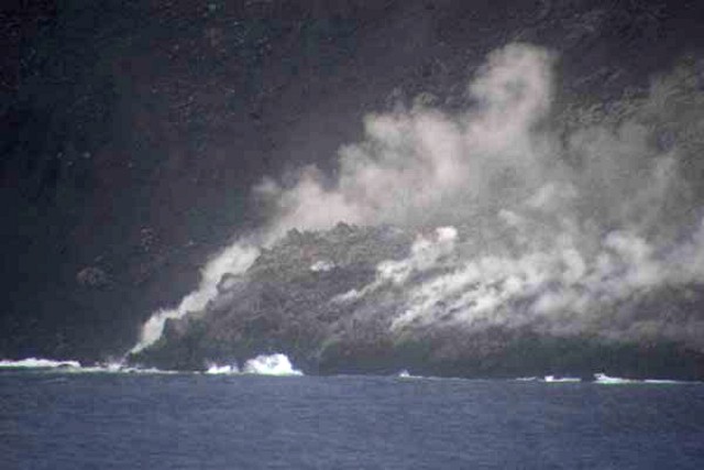 |
Figure 6. Lava blocks tumbling into the ocean on at Tinakula on the morning of 21 February 2006. Courtesy of Bill Yeaton. |
Information Contacts: Hawai'i Institute of Geophysics and Planetology (HIGP) Thermal Alerts System, School of Ocean and Earth Science and Technology (SOEST), Univ. of Hawai'i, 2525 Correa Road, Honolulu, HI 96822, USA (URL: http://modis.higp.hawaii.edu/); Bill Yeaton (URL: http://www.billyeaton.com/).
Eruption suggested by satellite thermal data and confirmed in the field
MODIS/MODVOLC satellite thermal alerts data for Tinakula (table 4) suggests continuing eruptive activity during the period mid-June 2007 through [mid-August] 2009; however, these data lack validation by field observations. Similar intermittent alerts have been detected since mid-February 2005 (BGVN 31:03, 32:03, and 32:07).
Table 4. MODIS/MODVOLC satellite thermal alerts measured at Tinakula during the period mid-June 2007 through early December 2009 (continued from table in BGVN 32:07). [Pixels originally reported on 15 February and 4 May could not be confirmed and may have been included by mistake.] Courtesy of the Hawai'i Institute of Geophysics and Planetology (HIGP) Thermal Alerts System.
| Date | Time (UTC) | Pixels | Satellite |
| 24 Sep 2007 | 1140 | 2 | Terra |
| 19 Oct 2007 | 1430 | 1 | Aqua |
| 09 Nov 2007 | 1150 | 1 | Terra |
| 19 Sep 2008 | 1130 | 1 | Terra |
| 26 Sep 2008 | 1140 | 1 | Terra |
| 04 Nov 2008 | 1145 | 1 | Terra |
| 29 Nov 2008 | 1440 | 2 | Aqua |
| 12 Aug 2009 | 1140 | 1 | Terra |
| 14 Aug 2009 | 1125 | 1 | Terra |
A possible observation of eruptive activity was found on a website by Clark Berge dated 22 September 2009: "A tall plume of steam and smoke streams from the top of a majestic cone rising direct from the sea.... During my visit to Temotu Province last week ... we circled [Tinakula in a motorized canoe], which seemed lush and harmless until we rounded a point and saw the steep black face of stone. Boulders were detaching themselves and bounding down the cliff amid a shower of sparks. I quickly realized the stones were glowing red!"
Information Contacts: Hawai'i Institute of Geophysics and Planetology (HIGP) Thermal Alerts System, School of Ocean and Earth Science and Technology (SOEST), Univ. of Hawai'i, 2525 Correa Road, Honolulu, HI 96822, USA (URL: http://modis.higp.hawaii.edu/); Clark Berge (URL: http://brclarkberge.blogspot.com/2009/09/tinakula-volcanoe.html).
Erupting in September 2009; ongoing MODVOLC thermal alerts into 2010
Tinakula displayed intermittent MODIS/MODVOLC satellite thermal alerts February 2006-November 2007, and September 2008-August 2009 (BGVN 31:03, 32:03, 32:07, 34:10). Ground observations are rare at this frequently active but uninhabited island.
No thermal alerts were recorded between 15 August 2009 and 16 January 2010, although there was a ground observation of "steam and smoke" above the summit and incandescent blocks rolling down the flanks in mid-September (BGVN 34:10). Thermal anomalies were detected between 17 January 2010 and 24 February 2010 (table 5).
Table 5. MODIS/MODVOLC satellite thermal alerts recorded at Tinakula during 1 January-7 March 2010. Courtesy of the Hawai'i Institute of Geophysics and Planetology (HIGP) Thermal Alerts System.
| Date | Time (UTC) | Pixels | Satellite |
| 17 Jan 2010 | 1150 | 1 | Terra |
| 28 Jan 2010 | 1130 | 1 | Terra |
| 28 Jan 2010 | 1435 | 1 | Aqua |
| 15 Feb 2010 | 1425 | 1 | Aqua |
| 19 Feb 2010 | 2329 | 1 | Terra |
| 20 Feb 2010 | 1135 | 2 | Terra |
| 20 Feb 2010 | 1440 | 2 | Aqua |
| 22 Feb 2010 | 1125 | 1 | Terra |
| 22 Feb 2010 | 1430 | 1 | Aqua |
| 24 Feb 2010 | 1415 | 1 | Aqua |
| 27 Feb 2010 | 1145 | 1 | Terra |
ASTER images of Tinakula over a wide date range are available from the Geological Survey of Japan's Image Database for Volcanoes. One such image (figure 7) shows activity from 13 April 2006 (BGVN 31:03). On the Flickr website there is an image of an eruptive plume on 27 August 2006.
Information Contacts: Hawai'i Institute of Geophysics and Planetology (HIGP) Thermal Alerts System, School of Ocean and Earth Science and Technology (SOEST), Univ. of Hawai'i, 2525 Correa Road, Honolulu, HI 96822, USA (URL: http://modis.higp.hawaii.edu/); Global Earth Observation Grid (GEO Grid), National Institute of Advanced Industrial Science and Technology (AIST) (URL: http://geodata1.geogrid.org/vsidb/image/index-E.html); and Advanced Spaceborne Thermal Emission and Reflection Radiometer (ASTER) (URL: http://asterweb.jpl.nasa.gov).
MODVOLC thermal alerts extend through September 2011
Our previous report on Tinakula (BGVN 35:01) summarized MODVOLC thermal alert data through 27 February 2010. This report notes MODVOLC alerts through September 2011. Tinakula is a rarely visited or monitored island in the Santa Cruz Island complex, which is part of the Solomon Island group in the South Pacific ocean (figures 8-10).
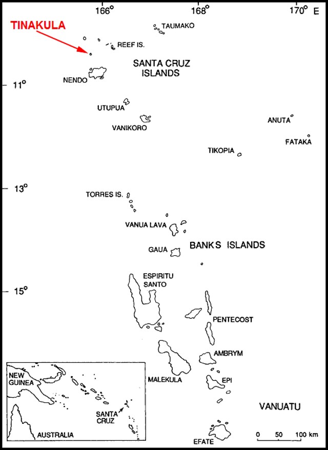 |
Figure 8. The location of Tinakula in the Santa Cruz Islands. Courtesy of McCoy and Cleghorn (1988). |
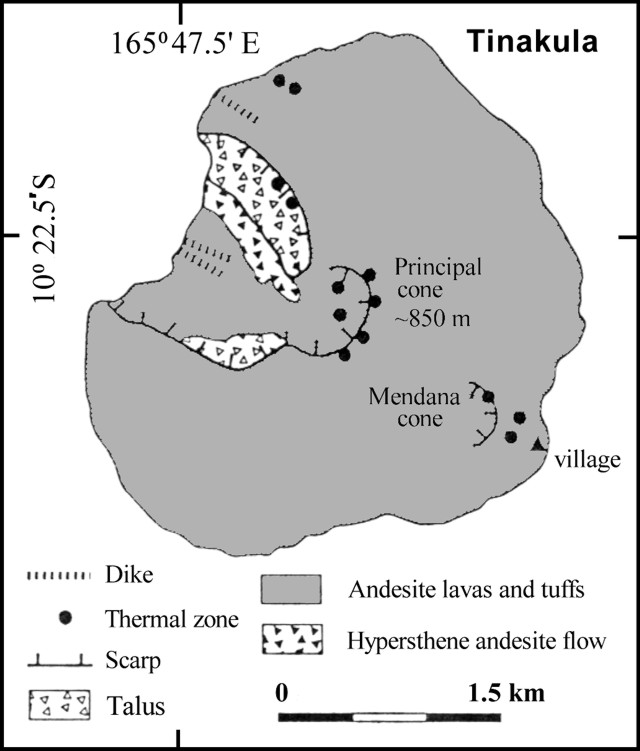 |
Figure 9. Sketch map of Tinakula island based on work and publications by G.W. Hughes (1972) and colleagues, and summarized by Eissen and others (1991). (This previously appeared in BGVN 28:01.) |
An image captured on 25 May 2010 by the MODIS instrument aboard the Aqua satellite, showed an ash plume from the volcano. It is not known whether plumes during the time period of this report were frequent.
MODVOLC thermal alerts continued through the rest of 2010 and through at least September 2011. During March 2010 through October 2010, the number of alerts ranged from zero to three per month. The number of alerts rose to 10 in November and to 20 in December, then decreased to 11 in January 2011. Between February and 26 September 2011, the number of alerts ranged from two to 12 per month. In July 2011, the two recorded alerts were 4 pixels each, a high during the time period for this report.
References. Eissen, J-P., Blot, C., and Louat, R., 1991, Chronology of the historic volcanic activity of the New Hebrides island arc from 1595 to 1991: Rapports Scientifiques et Technique, Sciences de la Terre, No. 2, ORSTOM, France.Hughes, G.W., 1972, Geological map of Tinakula: Nendö sheet EOI 1, Soloman Geol. Survey, Honiara.McCoy, P.C., and Cleghorn, 1988, Archaeological Excavations on Santa Cruz (Nendö), Southeast Solomon Islands: Summary Report, pp. 104-115 (map on 105 and at URL: http://www.jstor.org/stable/40386813?seq=2),in Archaeology in Oceania.
Information Contacts: Hawai'i Institute of Geophysics and Planetology (HIGP), MODVOLC Thermal Alerts System, School of Ocean and Earth Science and Technology (SOEST), Univ. of Hawai'i, 2525 Correa Road, Honolulu, HI 96822, USA (URL: http://modis.higp.hawaii.edu/); Iomoon.com (URL: http://www.iomoon.com/).
Thermal alerts measure probable continuing eruptions
Since our last report of July 2011 (BGVN 36:08), MODVOLC thermal alerts have continued to be measured at a rate of 3 to 11 days per month over Tinakula volcano, a volcano in frequent, if not constant eruption. Thermal alerts occurred over 11 days in January 2012 and 7 in February 2012. This trend of alerts has continued since about August 2010; the eruption is reported to have begun ~September 2008. According to NASA, "Over the past decade satellites have detected intermittent 'thermal anomalies' on the island that suggest eruptions have taken place, but eyewitness observations are infrequent."
During 13-14 February 2012, the satellite-borne MODIS radiometer detected a small plume in visible imagery (figure 11a). Figure 11b, a satellite image acquired 14 February 2012, shows a plume of volcanic gas, possibly mixed with a bit of ash, rising above the island's summit.
Information Contacts: Hawai’i Institute of Geophysics and Planetology (HIGP), MODVOLC Thermal Alerts System, School of Ocean and Earth Science and Technology (SOEST), Univ. of Hawai’i, 2525 Correa Road, Honolulu, HI 96822, USA (URL: http://modis.higp.hawaii.edu/); NASA Earth Observatory (URL: http://earthobservatory.nasa.gov/NaturalHazards/view.php?id=77183).
Recent observations on the volcano island
Since our recent brief report on Tinakula (BGVN 37:02), the Bulletin received an informal report from Timothy McConachy of Neptune Minerals, Inc., containing observations of Tinakula volcano made 10 May 2012 (Cook and others, 2012). Most of the following information in the next few paragraphs was extracted from that report.
The location of Tinakula with respect to other islands in the Santa Cruz Islands is shown in figure 12; figure 13 shows geological details of the Tinakula volcanic island.
Visit to Tinakula. Cook and others (2012) twice circumnavigated Tinakula clockwise in a banana boat with a 40-horse-power engine in the afternoon on Thursday, 10 May 2012. The day was sunny and clear with minor clouds and a NE breeze which stiffened during the afternoon; cloud cover increased during the afternoon. During the 2 transits they observed recent land slides, the NW collapse area (shown on Figure 13), and steam/gas plumes. A highlight of the visit was when red incandescent boulders of lava bounced down the large scree slope (up to 200-m-wide and 600- to 800-m-long) in the NW collapse sector. As they bounced, the boulders broke into smaller fragments and puffs of stream/gas were seen making white dotted tracks, or 'vapour trails' (figure 14). A number of the fragments from the larger boulders made their way into the sea, and plumes of steam rose along with the splash. When the larger boulders rolled into the sea, the authors could hear thudding sounds as they hit the water, followed by a hissing sound. At times the splash would rise 2 m or higher when the boulders hit the sea. Some of the boulders and fragments did not roll into the sea, but sat on the edge of the water, steaming and hissing for some time (between 3-5 min) before they cooled off.
To the naked eye, there appeared to be a steady cloud above Tinakula (figure 15), quite visible even from the town of Lata (~35 km S of Tinakula, located on Graciosa Bay, Nendö Island - aka Ndende Island, the provincial capital of Temotu Province in the far eastern Solomon Islands). It was difficult for Cook and others (2012) to photograph the incandescent color of the boulders and it only became apparent on the second time around the volcano in the later part of the afternoon when the area was backlit by the sun. The boulders originated from an area obscured by steam and gas. When the authors turned the outboard motor off, they could hear rumbling and small explosions at times. The size of the boulders was difficult to judge, but they thought that the larger ones were the size of a small car. They were surprised to see coconut palms growing up the slopes on most sides of the volcano, up to 50 m above sea level, possibly planted by locals.
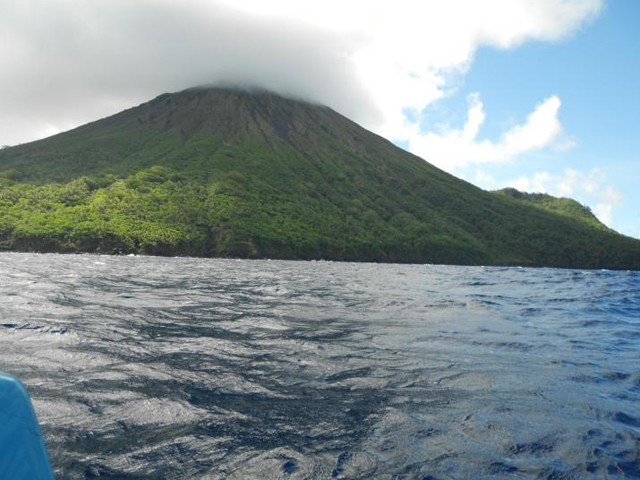 |
Figure 15. Cloud covering the summit of Tinakula at 1358 on 10 May 2012. The top of the volcano is virtually deforested. Courtesy of Cook and others (2012). |
Other comments. MODVOLC satellite thermal imagery continued to measure several thermal alerts almost daily.
References. Cook, H.J., Koraua, B.L., and McConachy, T.F., 2012, Observations of Tinakula Volcano, 10 May 2012, Solomon Islands (-10.38°S / 165.8°E), Informal report, 12 pp.
Eissen, J-P., Blot, C., and Louat, R., 1991, Chronology of the historic volcanic activity of the New Hebrides island arc from 1595 to 1991: Rapports Scientifiques et Technique, Sciences de la Terre, No. 2, ORSTOM, France.
Hughes, G.W., 1972, Geological map of Tinakula: Nendö sheet EOI 1, Soloman Geol. Survey, Honiara.
McCoy, P.C., and Cleghorn, 1988, Archaeological Excavations on Santa Cruz (Nendö), Southeast Solomon Islands: Summary Report, pp. 104-115; in Archaeology in Oceania.
Information Contacts: Timothy F. McConachy, Neptune Minerals, Inc. (URL: http://www.neptuneminerals.com); Brent McInnes, Commonwealth Scientific and Industrial Research Organisation (CSIRO), Australia (URL: http://www.csiro.au); MODVOLC, Hawai’i Institute of Geophysics and Planetology (HIGP) Thermal Alerts System, School of Ocean and Earth Science and Technology (SOEST), Univ. of Hawai’i, 2525 Correa Road, Honolulu, HI 96822, USA (URL: http://modis.higp.hawaii.edu/).
Abnormal rumbling after M 7.9 earthquake of 6 February 2013
Since the previous Bulletin report, which noted rumblings heard from the direction of the crater and small explosions emitting molten boulders (BGVN 37:06), there have been no further clear reports of eruptions that have come to our attention. A tectonic earthquake in February 2013 was accompanied by a cluster of foreshocks, a mainshock of magnitude M 7.9, followed by aftershocks. It took at least 10 lives. Around the time of the earthquake, 6 February, villagers on a neighboring island noted unusual activity, possibly associated with outgassing or a brief eruption at uninhabited Tinakula.
Anomalous volcano behavior. On 8 February, villagers of the island of Santa Cruz, among the closest inhabitants to Tinakula, reported having heard abnormal noises and rumblings coming from the volcano during the previous two days. First-hand reports also noted additional anomalies, including thin cloud cover around Tinakula's summit. The details remained equivocal and there were no similar announcements of uncharacteristic behavior during this reporting interval.
The Wellington Volcanic Ash Advisory Centre (VAAC) reported that the significant seismic activity led them to undertake an interval of heightened monitoring for both the volcanoes Traitor's Head in Vanuatu and Tinakula in the Solomon Islands (ICAO, 2014). Moreover, owing to the minor eruption of the volcano Gaua on the island of Vanuatu in April 2013, a Volcanic Ash Advisory was issued for the greater surrounding area, including the Tinakula region. The VAAC continued heightened monitoring through August 2013 due to the ongoing minor seismic activity and minor volcanic eruptions on White Island of New Zealand.
The following passages shift our discussion from the volcano to the regional geography and to events associated with the M 7.9 earthquake and tsunamis.
M 7.9 earthquake. The M 7.9 earthquake on 6 February 2013 occurred ~100 km SW of Tinakula (at 10.38°S, 165.8 °E), generating tsunamis at numerous monitoring locations (figure 16). As noted below, one aftershock, M 7, struck ~9 km from Tinakula but no damage was reported on the uninhabited island.
In the days preceding the 6 February event, more than 40 small earthquake events of M 4.5 or higher occurred within 80 km of the M 7.9 earthquake. The National Oceanographic and Atmospheric Administration (NOAA) noted that more than 12 of these were M 5-6; an additional 7 events were greater than M 6. The majority of the seismic activity had epicenters between 40 km SE and 68 km SW of Tinakula with focal depths of 10 to 46 km.
Strong aftershocks continued through 8 February 2013. The largest aftershocks in this recording period occurred on 8 February. One, M 7.0, had its epicenter 65 km SE of Tinakula. A second, M 7.0, at 10 km focal depth, had its epicenter only 9 km SSW of Tinakula.
Over the course of 6-8 February there were over 100 tsunami run- ups, with typical displacements of 1-2 m. The events spurred circum-Pacific tsunami warnings and collectively took 10-11 lives near the epicenter on islands such as Santa Cruz (Nendo), Tomotu Noi, and Lata. Damage included the destruction or serious damage to 743 houses, as well as a dock at Lata island.
The region is regularly rocked by large earthquakes and was struck on 28 October 2013 by one of M 7.7. No abnormal activity from the volcano was noted.
Reference. ICAO (International Civil Aviation Organization), (17-20 February) 2014, International Airways Volcano Watch Operations Group (IAVWOPSG); 8th Meeting, Melbourne, Australia, 17 to 20 February 2014, ICAO (URL: http://www.icao.int/safety/meteorology/iavwopsg/IAVWOPSG Meetings Metadata/IAVWOPSG.8.WP.024.5.en.pdf ).
Information Contacts: NOAA (URL: http://www.noaa.gov/); and Wellington Volcanic Ash Advisory Centre (VAAC) (URL: http://vaac.metservice.com/).
Short-lived ash emission and large SO2 plume 21-26 October 2017; historical eruption accounts
Remote Tinakula lies 100 km NE of the Solomon Trench at the N end of the Santa Cruz Islands, part of the country of the Solomon Islands, which generally lie 400 km to the W. It has been uninhabited since an eruption with lava flows and ash explosions in 1971 when the small population was evacuated (CSLP 87-71). The nearest inhabitants live on Te Motu (Trevanion) Island (about 30 km S), Nupani (40 km N), and the Reef Islands (60 km E); they occasionally report explosion noises from Tinakula. Ashfall from larger explosions has historically reached these islands. The last reported evidence of activity came from MODVOLC thermal alerts between August 2010 and October 2012, and observations of incandescent lava blocks rolling into the sea in May 2012. A new eruptive episode with a large ash explosion and substantial SO2 plume during 21-26 October 2017 is reported below, along with newly available historical newspaper accounts of earlier eruptions.
Reports of ash plumes are issued by the Wellington Volcanic Ash Advisory Center (VAAC); the National Disaster Management Office (NDMO) of the Solomon Islands Government also issues situation reports when significant activity is reported. Satellite data from infrared, visual, and SO2 monitoring instruments are an important source of information for this remote volcano. News reports from local (and social) media are often the only sources of information for the smaller events. Recently identified 19th- and 20th-century newspaper accounts of eruptive activity witnessed by sailors passing nearby is a valuable new resource for previously unreported events.
Eruption of 21-26 October 2017. Reports of a substantial explosion with an ash plume from Tinakula appeared on social media and in the local press during 22-26 October 2017. Staff from the Lata Met Service Office approached the island by boat on 23 October to make direct observations (figures 17-19). A video clip from the Himawari8 Satellite showing the ash plume explosion was posted by Stephan Armbruster on Twitter on 22 October. The Solomon Islands NDMO issued a situation report on 26 October showing ashfall covering vegetation on the island. According to the NDMO, ashfall was concentrated on the island, although a small amount of ash drifted SE and was reported to briefly contaminate drinking water in several communities in the nearby Reef Islands (60 km ENE) . Ashfall was also reported on Fenualoa Island (50 km ENE) (Radio New Zealand). The eruption was categorized by NMDO as a VEI 3. A team of geologists from NDMO brought seismic monitoring equipment to Tinakula in early November, and measured a high frequency volcanic tremor on 5 November 2017.
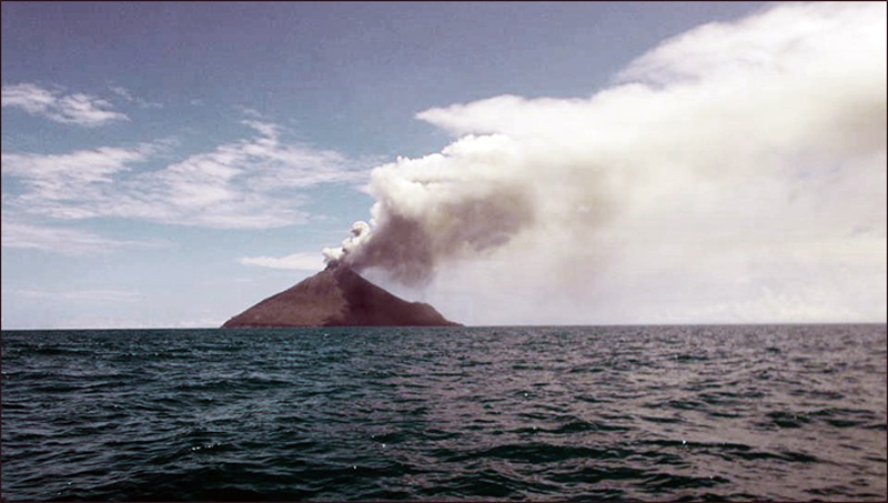 |
Figure 17. View from the SE of the eruption at Tinakula on 23 October 2017 during a site visit by staff from the Lata Office of the Solomon Islands Meteorological Service. Photo by Okano Gamara. |
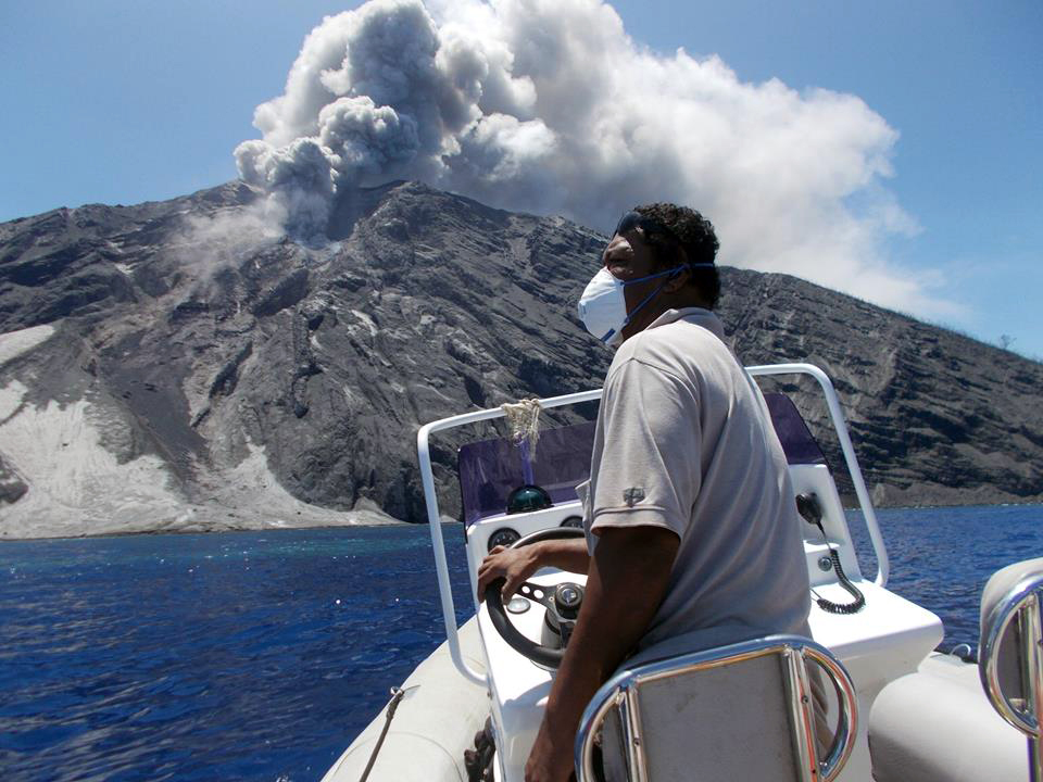 |
Figure 18. Ash and steam emissions rose from Tinakula on 23 October 2017 during a site visit by staff from the Lata Office of the Solomon Islands Meteorological Service. Photo by Okano Gamara. |
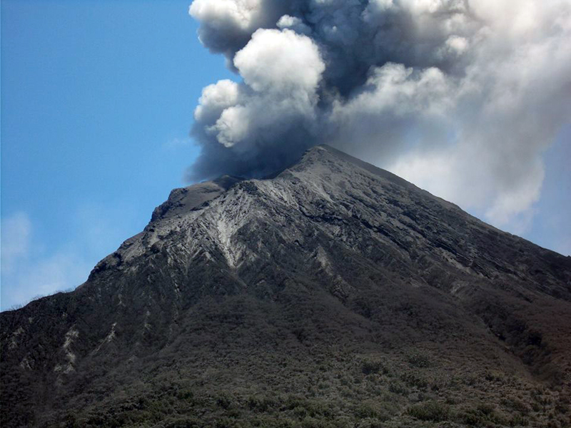 |
Figure 19. Ash emission from Tinakula on 23 October 2017 during a site visit by staff from the Lata Office of the Solomon Islands Meteorological Service. Photo by Okano Gamara. |
The Wellington VAAC first reported an ash plume visible in satellite imagery shortly after midnight (UTC) on 21 October 2017. The plume was estimated to be at 4.6 km altitude and drifting N. About 90 minutes later they reported a second eruption with a much higher plume drifting SE at 10.7 km altitude using IR imagery cloud top temperatures to estimate the altitude. They reported ongoing ash emissions visible in satellite imagery drifting SE at 6.1 km altitude throughout the morning, dropping to 3 km altitude by the end of the day. The following day, 22 October, intermittent ash emissions were reported at 3.7 km altitude moving E. By that afternoon, they had dropped to 2.4 km, and had lowered to 1.8 km by late on 23 October. Ongoing low-level ash emission (2.1 km altitude) continued through 25 October; by early on 26 October, there was no further evidence of ongoing activity.
No MODVOLC thermal alerts were associated with this event, but there was a brief MIROVA signal from the MODIS infrared data during 20-23 October 2017 (figure 20). A major SO2 plume was released from Tinakula on 21 October, and a smaller one was recorded on 28 October as well (figure 21).
Summary of activity during 1971-2012. After the 1971 eruption, intermittent ash emissions, lava bombs, and pyroclastic flows were reported by geologists and sailors passing nearby in 1984, 1985, 1989-1990, 1995, and 1999. Infrared MODIS thermal data was first reported as MODVOLC thermal alerts beginning in 2000 and has provided satellite-based confirmation of thermal activity since then. Months with thermal activity included February 2000-May 2001, February 2006-November 2007, September-November 2008, August 2009, and January 2010-October 2012 (figure 22). No additional thermal alerts were issued through 2017. Since 2004, SO2 data has been gathered by satellite instruments and processed by NASA Goddard Space Flight Center; in February and April 2006 small SO2 plumes were recorded (figure 23).
Eruption reports during 1868-1932. Reports of eruptions at Tinakula between 1868 and 1932 have recently been found in 19th and 20th century newspaper accounts from Australia and New Zealand (table 6). The accounts describe incandescence, water discoloration of the sea, explosions, ash plumes, and lava flows extending from the summit to the ocean.
Table 6. Newly discovered historical newspaper accounts of volcanic activity from ships passing near Tinakula between 1868 and 1932. This is not a full eruptive history for the time period. Online links provided in the References section. Courtesy of Steve Hutcheon.
| Date | Account | Reference |
| 17 Oct 1868 | Passed Volcano Island, one of the South (sic) Cruz group, on the 17th of October. It was then in active operation, vomiting forth immense volumes of fire and smoke. Note; Volcano Island is another name for Tinakula. | The Age, Melbourne, 10 November 1868, page 2b; also in The Argus, Melbourne, 10 November 1868, page 4b |
| 9 Oct 1869 | On the 9th October sighted three low islands, also Volcano Island; the discharge from the latter was plainly visible. | The Empire, Sydney, 27 October 1869, page 2a |
| 29/30 Nov 1871 | During the night, the active volcano, Tinakula, was passed. Large masses of red hot lava were emitted; and the sight is described as being very imposing and grand. | The Sydney Morning Herald, 19 February 1872, page 6a |
| 20 Jun 1887 | When his vessel was off the Santa Cruz group Mount Tinakula became an active volcano. It broke out at 4 o'clock on the morning of June 20 and viewed from the ship's deck presented a most grand spectacle. The water for miles round was of a pea green color and had the appearance of being very shallow. | The Daily Telegraph, Sydney, NSW, 20 July 1887, page 4f |
| ~23 Aug 1910 | Tinakula Island was found to be in an active state of eruption, and presented a fine sight. The ship Tambo departed Tarawa 19 August and arrived in Sydney on 31 August 1910. | The Daily Telegraph, Sydney, NSW, 1 September 1910, page 7a |
| 2/3 May 1932 | The steamer passed within half a mile of the active volcano of Tinakula. It was at night, and the passengers obtained a remarkable view of the red hot lava streams flowing from the summit, which is 2000 ft. high, to the water's edge. Three eruptions occurred while the vessel was within view of the island, each preceded by an explosion which sounded like thunder. | The New Zealand Herald, Auckland, NZ, 27 June 1932, page 6a; The Auckland Star, 10 September 1932 page 1h (Supplement) |
References. The Age (Melbourne, Victoria) 10 November 1868, page 2b (URL: http://nla.gov.au/nla.news-article177002744).
The Empire (Sydney, NSW) 27 October 1869, page 2a, (URL: http://nla.gov.au/nla.news-article60895166).
The Sydney Morning Herald (NSW) 19 Februay 1872, page 6a (URL: http://nla.gov.au/nla.news-article13252748).
The Daily Telegraph (Sydney, NSW) 1887 20 July, page 4f (URL: http://nla.gov.au/nla.news-article239817295).
The Daily Telegraph (Sydney, NSW) 1 September 1910, page 7a (URL: http://nla.gov.au/nla.news-article237993807; http://nla.gov.au/nla.news-article15183461 ).
The New Zealand Herald (Auckland, NZ) 27 June 1932, page 6a (URL: https://paperspast.natlib.govt.nz/newspapers/NZH19320627.2.19 ).
The Auckland Star (NZ) 10 September 1932, page 1h (Supplement) (URL: https://paperspast.natlib.govt.nz/newspapers/AS19320910.2.180.6 ).
Information Contacts: National Disaster Management Office (NDMO), Solomon Islands Government, Prince Philip Highway, Ranadi, Solomon Islands (URL: http://www.ndmo.gov.sb); Wellington Volcanic Ash Advisory Centre (VAAC), Meteorological Service of New Zealand Ltd (MetService), PO Box 722, Wellington, New Zealand (URL: http://www.metservice.com/vaac/, http://www.ssd.noaa.gov/VAAC/OTH/NZ/messages.html); Hawai'i Institute of Geophysics and Planetology (HIGP), MODVOLC Thermal Alerts System, School of Ocean and Earth Science and Technology (SOEST), Univ. of Hawai'i, 2525 Correa Road, Honolulu, HI 96822, USA (URL: http://modis.higp.hawaii.edu/); MIROVA (Middle InfraRed Observation of Volcanic Activity), a collaborative project between the Universities of Turin and Florence (Italy) supported by the Centre for Volcanic Risk of the Italian Civil Protection Department (URL: http://www.mirovaweb.it/); NASA Goddard Space Flight Center (NASA/GSFC), Global Sulfur Dioxide Monitoring Page, Atmospheric Chemistry and Dynamics Laboratory, 8800 Greenbelt Road, Goddard, Maryland, USA (URL: http://so2.gsfc.nasa.gov/index.html ); Radio New Zealand (URL: http://www.radionz.co.nz/international/pacific-news/342267/solomons-pm-calls-for-calm-in-communities-close-to-volcano); Solomon Islands Broadcasting Corporation, SIBC Voice of the Nation, Honiara, Solomon Islands (URL: http://www.sibconline.com.sb/no-its-not-snow-in-the-solomons-its-ash-from-the-tinakula-volcano/); Andy Prata, AIRES Atmospheric Industrial Research and Environmental Solutions, Melbourne, Australia (URL: https://www.aires.space/, https://twitter.com/andyprata/status/922177129944625157); Gamara Okzman Bencarson, Facebook.
Thermal anomalies in satellite data December 2018-June 2019; ship visit January 2019
Remote Tinakula lies 100 km NE of the Solomon Trench at the N end of the Santa Cruz Islands, which are part of the country of the Solomon Islands located 400 km to the W. It has been uninhabited since an eruption with lava flows and ash explosions in 1971 when the small population was evacuated (CSLP 87-71). The nearest communities live on Te Motu (Trevanion) Island (about 30 km S), Nupani (40 km N), and the Reef Islands (60 km E); residents occasionally report noises from explosions at Tinakula. Ashfall from larger explosions has historically reached these islands. The most recent eruptive episode was a large ash explosion and substantial SO2 plume during 21-26 October 2017; satellite imagery suggested that a flow of some type traveled down the scarp on the W flank. Renewed thermal activity that was recognized in satellite imagery beginning in December 2018 continued intermittently through June 2019 and is covered in this report. Satellite imagery and thermal data are the primary sources of information for this volcano. It is occasionally visited by members of the National Disaster Management Office (NDMO) of the Solomon Islands Government, tourists, and research vessels who are able to capture ground-based information.
Satellite images from December 2018 to February 2019 show thermal anomalies at the summit vent. Excellent ship-based photographs of the island on 24-25 January 2019 provided by a crewmember from the R/V Petrel identify numerous volcanic features and show a steam-and-gas plume at the vent. Satellite images from April and May 2019 show thermal anomalies at both the summit vent and along the W flank scarp suggesting flow activity during that time.
A stream of incandescence on the NW flank of Tinakula in a Sentinel 2 satellite image on 24 October 2017 confirmed that some type of high-temperature flow accompanied the explosions and eruptive activity of 21-25 October 2017 (BGVN 43:02). Satellite imagery during most of 2018 recorded steam plumes drifting in several directions from the summit, but no thermal activity (figure 24). There was no further evidence of activity in satellite visible or thermal data until almost exactly one year later when the MIROVA project recorded two thermal alerts in the third week of October 2018 (figure 25). Satellite images from that week were cloudy and did not confirm any surface activity.
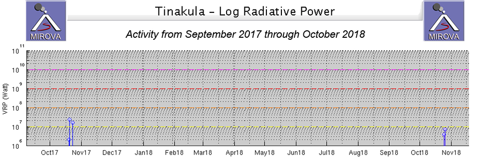 |
Figure 25. The MIROVA project recorded the first thermal anomaly in a year from Tinakula during the third week of October 2018. Courtesy of MIROVA. |
The first satellite imagery confirming renewed thermal activity appeared on 8 December 2018, around the same time as a small MIROVA anomaly. After that, several images during January and February 2019 confirmed moderately strong thermal activity at the summit (figure 26). Whether the anomalies were the result of active lava effusion or strong incandescent gases from the summit vent is uncertain.
Visual confirmation of activity at Tinakula is rare, but the research vessel R/V Petrel sailed past the volcano on 24 and 25 January 2019 and a crewmember provided detailed images of the W flank and vent area. The summit vent is located at the top of a W facing scarp, and steam is frequently observed rising from the vent (figures 27). Recent flows and volcaniclastic deposits were visible in the ravine on the W flank (figures 28 and 29). Fresh-looking lava was also visible near the summit vent on top of older deposits (figure 30). Eroded volcaniclastic deposits near the base of the scarp on the W flank were visible on top of older veined and layered volcanic rocks (figure 31). Crewmembers on the vessel R/V Petrel could clearly see an incandescent glow from the summit crater at night (figure 32).
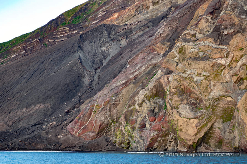 |
Figure 31. The W flank of Tinakula on 24-25 January 2019. Eroded volcaniclastic deposits overlie older veined and layered volcanic rocks. Used with permission from Paul G Allen's Vulcan Inc. |
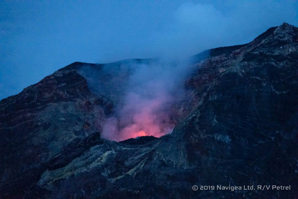 |
Figure 32. Incandescence was clearly visible from the summit vent at Tinakula on 24-25 January 2019. Used with permission from Paul G Allen's Vulcan Inc. |
During April and May 2019, both the MIROVA project and MODVOLC measured a number of thermal anomalies (figure 33) using MODIS satellite data. MODVOLC alerts were issued on 4 and 20 April, and 11, 18, and 27 May. Sentinel-2 satellite images during the period confirmed that a flow on the W flank was a likely source of the thermal energy in addition to the summit vent (figure 34). Thermal anomalies appeared again at the end of June in MIROVA data, but no satellite images showed anomalies at that time.
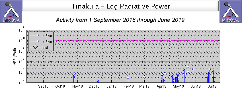 |
Figure 33. The number and intensity of MIROVA thermal anomalies increased at Tinakula during April and May 2019. After a short pause, they returned at the end of June. Courtesy of MIROVA. |
Information Contacts: MIROVA (Middle InfraRed Observation of Volcanic Activity), a collaborative project between the Universities of Turin and Florence (Italy) supported by the Centre for Volcanic Risk of the Italian Civil Protection Department (URL: http://www.mirovaweb.it/); Hawai'i Institute of Geophysics and Planetology (HIGP) - MODVOLC Thermal Alerts System, School of Ocean and Earth Science and Technology (SOEST), Univ. of Hawai'i, 2525 Correa Road, Honolulu, HI 96822, USA (URL: http://modis.higp.hawaii.edu/); Sentinel Hub Playground (URL: https://www.sentinel-hub.com/explore/sentinel-playground); Vulcan Inc. (URL: https://www.vulcan.com/), additional details about the R/V Petrel (URL: https://www.paulallen.com/).
Intermittent thermal activity suggests ongoing eruption, July-December 2019
Remote Tinakula lies 100 km NE of the Solomon Trench at the N end of the Santa Cruz Islands, which are part of the South Pacific country of the Solomon Islands located 400 km to the W. It has been uninhabited since an eruption with lava flows and ash explosions in 1971 when the small population was evacuated (CSLP 87-71). The nearest communities live on Te Motu (Trevanion) Island (about 30 km S), Nupani (40 km N), and the Reef Islands (60 km E); residents occasionally report noises from explosions at Tinakula. Ashfall from larger explosions has historically reached these islands. A large ash explosion during 21-26 October 2017 was a short-lived event; renewed thermal activity was detected beginning in December 2018 and intermittently throughout 2019. This report covers the ongoing activity from July-December 2019. Since ground-based observations are rarely available, satellite thermal and visual data are the primary sources of information.
MIROVA thermal anomaly data indicated intermittent but ongoing thermal activity at Tinakula during July-December 2019 (figure 35). It was characterized by pulses of multiple alerts of varying intensities for several days followed by no activity for a few weeks.
Observations using Sentinel-2 satellite imagery were often prevented by clouds during July, but two MODVOLC thermal alerts on 2 July 2019 corresponded to MIROVA thermal activity on that date. No thermal anomalies were reported by MIROVA during August 2019, but Sentinel-2 satellite images showed dense steam plumes drifting away from the summit on four separate dates (figure 36). Two distinct thermal anomalies appeared in infrared imagery on 9 September, and a dense steam plume drifted about 10 km NW on 14 September (figure 37).
During October 2019 steam emissions were captured in four clear satellite images; a weak thermal anomaly was present on the W flank on 9 October (figure 38). MODVOLC recorded a single thermal alert on 9 November. Stronger thermal anomalies appeared twice during November in satellite images. On 13 November a strong anomaly was present at the summit in Sentinel-2 imagery; it was accompanied by a dense steam plume drifting NE from the hotspot. On 28 November two thermal anomalies appeared part way down the upper NW flank (figure 39). Thermal imagery on 3 December suggested that a weak anomaly remained on the NW flank in a similar location; a dense steam plume rose above the summit, drifting slightly SW on 18 December (figure 40). A thermal anomaly at the summit on 28 December was accompanied by a dense steam plume and corresponded to multiple MIROVA thermal anomalies at the end of December.
Information Contacts: MIROVA (Middle InfraRed Observation of Volcanic Activity), a collaborative project between the Universities of Turin and Florence (Italy) supported by the Centre for Volcanic Risk of the Italian Civil Protection Department (URL: http://www.mirovaweb.it/); Hawai'i Institute of Geophysics and Planetology (HIGP) - MODVOLC Thermal Alerts System, School of Ocean and Earth Science and Technology (SOEST), Univ. of Hawai'i, 2525 Correa Road, Honolulu, HI 96822, USA (URL: http://modis.higp.hawaii.edu/); Sentinel Hub Playground (URL: https://www.sentinel-hub.com/explore/sentinel-playground).
Intermittent small thermal anomalies and gas-and-steam plumes during January-June 2020
Tinakula is a remote stratovolcano located 100 km NE of the Solomon Trench at the N end of the Santa Cruz. In 1971, an eruption with lava flows and ash explosions caused the small population to evacuate the island. Volcanism has previously been characterized by an ash explosion in October 2017 and the most recent eruptive period that began in December 2018 with renewed thermal activity. Activity since then has consisted of intermittent thermal activity and dense gas-and-steam plumes (BGVN 45:01), which continues into the current reporting period. This report updates information from January-June 2020 using primary source information from various satellite data, as ground observations are rarely available.
MIROVA (Middle InfraRed Observation of Volcanic Activity) analysis of MODIS satellite data showed weak, intermittent, but ongoing thermal activity during January-June 2020 (figure 41). A small cluster of slightly stronger thermal signatures was detected in late February to early March, which is correlated to MODVOLC thermal alert data; four thermal hotspots were recorded on 20, 27, and 29 February and 1 March. However, observations using Sentinel-2 satellite imagery were often obscured by clouds. In addition to the weak thermal signatures, dense gas-and-steam plumes were observed in Sentinel-2 satellite imagery rising from the summit during this reporting period (figure 42).
Three distinct thermal anomalies were observed in Sentinel-2 thermal satellite imagery on 22 January, 11 April, and 6 May 2020, accompanied by some gas-and-steam emissions (figure 43). The hotspot on 22 January was slightly weaker than the other two days, and was seen on the W flank, compared to the other two that were observed in the summit crater. According to MODVOLC thermal alerts, a hotspot was recorded on 6 May, which corresponded to a Sentinel-2 thermal satellite image with a notable anomaly in the summit crater (figure 43). On 10 June no thermal anomaly was seen in Sentinel-2 satellite imagery due to the presence of clouds; however, what appeared to be a dense gas-and-steam plume was extending W from the summit.
Information Contacts: MIROVA (Middle InfraRed Observation of Volcanic Activity), a collaborative project between the Universities of Turin and Florence (Italy) supported by the Centre for Volcanic Risk of the Italian Civil Protection Department (URL: http://www.mirovaweb.it/); Hawai'i Institute of Geophysics and Planetology (HIGP) - MODVOLC Thermal Alerts System, School of Ocean and Earth Science and Technology (SOEST), Univ. of Hawai'i, 2525 Correa Road, Honolulu, HI 96822, USA (URL: http://modis.higp.hawaii.edu/); Sentinel Hub Playground (URL: https://www.sentinel-hub.com/explore/sentinel-playground).
Intermittent gas-and-steam plumes and weak thermal anomalies during July-December 2020
Tinakula is located 100 km NE of the Solomon Trench at the N end of the Santa Cruz. The current eruption began in December 2018 and has recently been characterized by intermittent small thermal anomalies and gas-and-steam plumes (BGVN 45:07), which continued into the current reporting period of July-December 2020. Information primarily comes from various satellite data, as ground observations are rarely available.
Infrared MODIS satellite data processed by MIROVA (Middle InfraRed Observation of Volcanic Activity) showed a total of ten low-power thermal anomalies during July through December; one anomaly was detected in early July, two in late August, three in November, and four in December (figure 44). A single MODVOLC alert was issued on 16 December, which was visible in Sentinel-2 thermal satellite imagery on 17 December (figure 45). Though clouds often obscured the view of the summit crater, Sentinel-2 satellite imagery showed intermittent dense gas-and-steam plumes rising from the summit that drifted in different directions (figure 45).
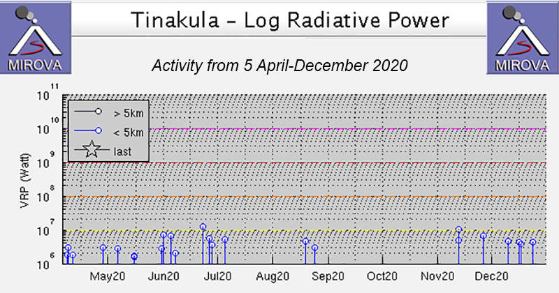 |
Figure 44. Low-power thermal anomalies at Tinakula were detected intermittently during April-December 2020 by the MIROVA system (Log Radiative Power). Courtesy of MIROVA. |
Information Contacts: MIROVA (Middle InfraRed Observation of Volcanic Activity), a collaborative project between the Universities of Turin and Florence (Italy) supported by the Centre for Volcanic Risk of the Italian Civil Protection Department (URL: http://www.mirovaweb.it/); Hawai'i Institute of Geophysics and Planetology (HIGP) - MODVOLC Thermal Alerts System, School of Ocean and Earth Science and Technology (SOEST), Univ. of Hawai'i, 2525 Correa Road, Honolulu, HI 96822, USA (URL: http://modis.higp.hawaii.edu/); Sentinel Hub Playground (URL: https://www.sentinel-hub.com/explore/sentinel-playground).
Ongoing white gas-and-steam plumes and a persistent thermal anomaly during January-June 2021
Tinakula, located 100 km NE of the Solomon Trench at the N end of the Santa Cruz Islands, is a small 3.5-km-wide island with a breached summit crater that extends to below sea level. Its most recent eruption period began in December 2018 and has recently been characterized by intermittent gas-and-steam plumes and weak thermal anomalies (BGVN 46:01). Evidence of similar activity continued during this reporting period of January through June 2021 based on various satellite data; ground observations are rarely available.
Infrared MODIS satellite data processed by MIROVA (Middle InfraRed Observation of Volcanic Activity) showed fifteen low-power thermal anomalies during January through June 2021: one in early January, two in late February, four during March, five during mid- to late April, two during early May, and one in early June (figure 46). Some of these anomalies were also observed in Sentinel-2 infrared satellite imagery, occasionally accompanied by white gas-and-steam plumes drifting SW and E (figure 47).
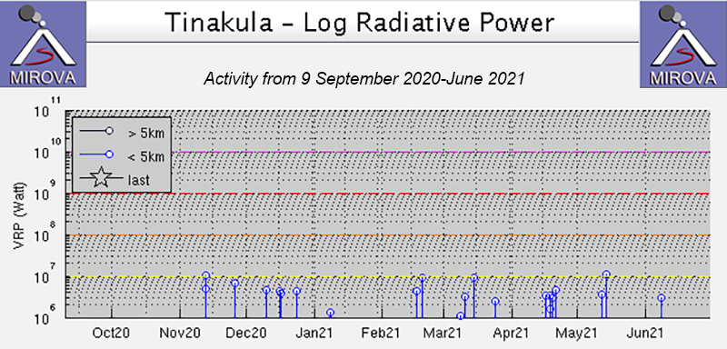 |
Figure 46. Low-power thermal anomalies at Tinakula were detected fifteen times during January through June 2021, based on the MIROVA system (Log Radiative Power). Courtesy of MIROVA. |
Information Contacts: MIROVA (Middle InfraRed Observation of Volcanic Activity), a collaborative project between the Universities of Turin and Florence (Italy) supported by the Centre for Volcanic Risk of the Italian Civil Protection Department (URL: http://www.mirovaweb.it/); Sentinel Hub Playground (URL: https://www.sentinel-hub.com/explore/sentinel-playground).
Thermal anomalies, gas-and-steam emissions, and possible lava flows during July-December 2021
Tinakula is located 100 km NE of the Solomon Trench at the N end of the Santa Cruz Islands. It is a small 3.5-km-wide island with a breached summit crater that extends to below sea level; landslides enlarged this scarp in 1965, creating an embayment on the NW coast. Its most recent eruption period began in December 2018 and has consisted of weak thermal anomalies and intermittent gas-and-steam plumes. Similar activity continued during this reporting period from July through December 2021 based on satellite data, as ground observations are rarely available.
Infrared MODIS satellite data processed by MIROVA (Middle InfraRed Observation of Volcanic Activity) detected a total of 18 weak thermal anomalies during July through December: once during late July, three times during early August, seven times during October, four times during November, and three times during late December (figure 48).
Though cloudy weather often obscured clear views of the summit crater, Sentinel-2 infrared satellite imagery showed a possible lava flow descending the NW flank accompanied by gas-and-steam emissions that drifted NW on 28 October (figure 49). By 27 November the flow on the NW flank had cooled, but there were two small anomalies on the W flank that may represent a different lava flow. On 22 December two small possible lava flows moved a short distance from the summit crater to the NW and W; gas-and-steam emissions drifted generally W.
Information Contacts: MIROVA (Middle InfraRed Observation of Volcanic Activity), a collaborative project between the Universities of Turin and Florence (Italy) supported by the Centre for Volcanic Risk of the Italian Civil Protection Department (URL: http://www.mirovaweb.it/); Sentinel Hub Playground (URL: https://www.sentinel-hub.com/explore/sentinel-playground).
Ongoing thermal anomalies and gas-and-steam plumes during January-September 2022
Tinakula is a remote stratovolcano in the SE part of the Solomon Islands. Recent activity began with an ash explosion in October 2017, followed in December 2018 by dense gas-and-steam plumes and weak thermal anomalies (BGVN 44:07, 47:02), which continued into 2022. The current report summarizes activity during January-September 2022 using satellite data, as ground observations are rarely available.
Infrared MODIS satellite data processed by MIROVA (Middle InfraRed Observation of Volcanic Activity) detected intermittent low-power thermal anomalies each month except for September 2022 when none were detected (figure 50). More frequent anomalies were detected from mid-February through March 2022.
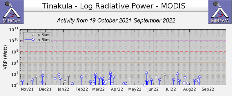 |
Figure 50. Graph of thermal anomalies (Log Radiative Power) at Tinakula from the MIROVA system through September 2022. Courtesy of MIROVA. |
Sentinel-2 satellite imagery showed persistent white gas-and-steam plumes rising from Tinakula during January through September 2022. Almost all observed plumes drifted W or SW and were usually profuse and dense. On the few viewing days when not obscured by the plumes or weather clouds, a thermal anomaly was visible at the summit area (figure 51); three small thermal anomalies were visible on 23 September.
Information Contacts: MIROVA (Middle InfraRed Observation of Volcanic Activity), a collaborative project between the Universities of Turin and Florence (Italy) supported by the Centre for Volcanic Risk of the Italian Civil Protection Department (URL: http://www.mirovaweb.it/); Sentinel Hub Playground (URL: https://www.sentinel-hub.com/explore/sentinel-playground).
Ongoing intermittent lava flows and thermal anomalies during October 2022-May 2023
Tinakula is a remote 3.5 km-wide island in the Solomon Islands, 640 km ESE of the capital, Honiara. Recent activity of the island’s stratovolcano began with an ash explosion in October 2017, followed in December 2018 by dense gas-and-steam plumes and thermal anomalies from lava flows (BGVN 44:07, 47:02), which continued into 2023. The current report summarizes activity during October 2022-May 2023 using satellite data.
When the weather was clear Sentinel-2 satellite imagery showed lava flows and persistent white gas-and-steam plumes rising from the crater during October 2022-May 2023. Infrared MODIS satellite data processed by MIROVA (Middle InfraRed Observation of Volcanic Activity) detected intermittent low-power hotspots during the reporting period, but more frequent and intense anomalies during late April 2023 due to lava flows on the NW flank.
Imagery on 13 October 2022 showed a narrow lava flow on the NW flank reaching the ocean. The flow appeared larger in infrared images when visible on 23 October and 12 November (figure 52). Although small thermal anomalies were present in the summit area, no significant activity was detected through mid-April 2023. On 26 April another lava flow (figure 52), larger than the previous October-November, again reached the ocean, consistent with the more intense MODIS data. Several strong sulfur dioxide emissions were recorded by the TROPOMI instrument on the Sentinel-5P satellite between 28 April-19 May 2023, the most prominent one on 9 May (figure 52).
Information Contacts: Sentinel Hub Playground (URL: https://www.sentinel-hub.com/explore/sentinel-playground); MIROVA (Middle InfraRed Observation of Volcanic Activity), a collaborative project between the Universities of Turin and Florence (Italy) supported by the Centre for Volcanic Risk of the Italian Civil Protection Department (URL: http://www.mirovaweb.it/); NASA Global Sulfur Dioxide Monitoring Page, Atmospheric Chemistry and Dynamics Laboratory, NASA Goddard Space Flight Center (NASA/GSFC), 8800 Greenbelt Road, Goddard, Maryland, USA (URL: https://so2.gsfc.nasa.gov/).
Continued lava flows and thermal activity during June through November 2023
Tinakula is a remote 3.5 km-wide island in the Solomon Islands, located 640 km ESE of the capital, Honiara. The current eruption period began in December 2018 and has more recently been characterized by intermittent lava flows and thermal activity (BGVN 48:06). This report covers similar activity during June through November 2023 using satellite data.
During clear weather days (20 July, 23 September, 23 October, and 12 November), infrared satellite imagery showed lava flows that mainly affected the W side of the island and were sometimes accompanied by gas-and-steam emissions (figure 54). The flow appeared more intense during July and September compared to October and November. According to the MODVOLC thermal alerts, there were a total of eight anomalies detected on 19 and 21 July, 28 and 30 October, and 16 November. Infrared MODIS satellite data processed by MIROVA (Middle InfraRed Observation of Volcanic Activity) detected a small cluster of thermal activity occurring during late July, followed by two anomalies during August, two during September, five during October, and five during November (figure 55).
Information Contacts: MIROVA (Middle InfraRed Observation of Volcanic Activity), a collaborative project between the Universities of Turin and Florence (Italy) supported by the Centre for Volcanic Risk of the Italian Civil Protection Department (URL: http://www.mirovaweb.it/); Hawai'i Institute of Geophysics and Planetology (HIGP) - MODVOLC Thermal Alerts System, School of Ocean and Earth Science and Technology (SOEST), Univ. of Hawai'i, 2525 Correa Road, Honolulu, HI 96822, USA (URL: http://modis.higp.hawaii.edu/); Copernicus Browser, Copernicus Data Space Ecosystem, European Space Agency (URL: https://dataspace.copernicus.eu/browser/).
|
|
||||||||||||||||||||||||||||
There is data available for 24 confirmed eruptive periods.
2018 Dec 8 (on or before) - 2024 Dec 31 Confirmed Eruption (Explosive / Effusive) VEI: 0
| Episode 1 | Eruption (Explosive / Effusive) | Summit vent and NW flank | ||||||||||||||||||||||||||||||||||||||||||||||||||||||||||||||||||||||||||||||||||||||||||||||||||||||||||||||||||||||||||||||||||||||||||||||||||||||||||||||
|---|---|---|---|---|---|---|---|---|---|---|---|---|---|---|---|---|---|---|---|---|---|---|---|---|---|---|---|---|---|---|---|---|---|---|---|---|---|---|---|---|---|---|---|---|---|---|---|---|---|---|---|---|---|---|---|---|---|---|---|---|---|---|---|---|---|---|---|---|---|---|---|---|---|---|---|---|---|---|---|---|---|---|---|---|---|---|---|---|---|---|---|---|---|---|---|---|---|---|---|---|---|---|---|---|---|---|---|---|---|---|---|---|---|---|---|---|---|---|---|---|---|---|---|---|---|---|---|---|---|---|---|---|---|---|---|---|---|---|---|---|---|---|---|---|---|---|---|---|---|---|---|---|---|---|---|---|---|---|---|
| 2018 Dec 8 (on or before) - 2024 Dec 31 | Evidence from Observations: Reported | ||||||||||||||||||||||||||||||||||||||||||||||||||||||||||||||||||||||||||||||||||||||||||||||||||||||||||||||||||||||||||||||||||||||||||||||||||||||||||||||
|
List of 30 Events for Episode 1 at Summit vent and NW flank
|
|||||||||||||||||||||||||||||||||||||||||||||||||||||||||||||||||||||||||||||||||||||||||||||||||||||||||||||||||||||||||||||||||||||||||||||||||||||||||||||||
2017 Oct 21 - 2017 Oct 26 Confirmed Eruption (Explosive / Effusive) VEI: 3
| Episode 1 | Eruption (Explosive / Effusive) | Summit crater | |||||||||||||||||||||||||||||||||||||||||||||||||||||||||||||||||||||||||
|---|---|---|---|---|---|---|---|---|---|---|---|---|---|---|---|---|---|---|---|---|---|---|---|---|---|---|---|---|---|---|---|---|---|---|---|---|---|---|---|---|---|---|---|---|---|---|---|---|---|---|---|---|---|---|---|---|---|---|---|---|---|---|---|---|---|---|---|---|---|---|---|---|---|---|
| 2017 Oct 21 - 2017 Oct 26 | Evidence from Observations: Reported | |||||||||||||||||||||||||||||||||||||||||||||||||||||||||||||||||||||||||
|
List of 13 Events for Episode 1 at Summit crater
|
||||||||||||||||||||||||||||||||||||||||||||||||||||||||||||||||||||||||||
2008 Sep 19 (?) - 2008 Nov 29 (?) Confirmed Eruption (Explosive / Effusive) VEI: 1 (?)
| Episode 1 | Eruption (Explosive / Effusive) | ||||||||||||||||||||||||
|---|---|---|---|---|---|---|---|---|---|---|---|---|---|---|---|---|---|---|---|---|---|---|---|---|
| 2008 Sep 19 (?) - 2008 Nov 29 (?) | Evidence from Observations: Reported | |||||||||||||||||||||||
|
List of 3 Events for Episode 1
|
||||||||||||||||||||||||
2006 Feb 11 - 2007 Nov 9 (?) Confirmed Eruption (Explosive / Effusive) VEI: 2
| Episode 1 | Eruption (Explosive / Effusive) | |||||||||||||||||||
|---|---|---|---|---|---|---|---|---|---|---|---|---|---|---|---|---|---|---|---|
| 2006 Feb 11 - 2007 Nov 9 (?) | Evidence from Observations: Reported | ||||||||||||||||||
|
List of 2 Events for Episode 1
|
|||||||||||||||||||
[ 2002 Nov 16 ± 15 days ] Uncertain Eruption
| Episode 1 | Eruption (Explosive / Effusive) | ||||||||||||||
|---|---|---|---|---|---|---|---|---|---|---|---|---|---|---|
| 2002 Nov 16 ± 15 days - Unknown | Evidence from Unknown | |||||||||||||
|
List of 1 Events for Episode 1
|
||||||||||||||
[ 2002 Apr 16 ± 15 days ] Uncertain Eruption
| Episode 1 | Eruption (Explosive / Effusive) | Upper NW flank | |||||||||||||||||||||||
|---|---|---|---|---|---|---|---|---|---|---|---|---|---|---|---|---|---|---|---|---|---|---|---|---|
| 2002 Apr 16 ± 15 days - Unknown | Evidence from Observations: Reported | |||||||||||||||||||||||
|
List of 3 Events for Episode 1 at Upper NW flank
|
||||||||||||||||||||||||
2000 Feb 29 (?) - 2001 May 8 (?) Confirmed Eruption (Explosive / Effusive) VEI: 1 (?)
| Episode 1 | Eruption (Explosive / Effusive) | |||||||||||||||||||
|---|---|---|---|---|---|---|---|---|---|---|---|---|---|---|---|---|---|---|---|
| 2000 Feb 29 (?) - 2001 May 8 (?) | Evidence from Observations: Reported | ||||||||||||||||||
|
List of 2 Events for Episode 1
|
|||||||||||||||||||
1999 May 16 ± 15 days Confirmed Eruption (Explosive / Effusive) VEI: 1 (?)
| Episode 1 | Eruption (Explosive / Effusive) | ||||||||||||||||||||||||
|---|---|---|---|---|---|---|---|---|---|---|---|---|---|---|---|---|---|---|---|---|---|---|---|---|
| 1999 May 16 ± 15 days - Unknown | Evidence from Observations: Reported | |||||||||||||||||||||||
|
List of 3 Events for Episode 1
|
||||||||||||||||||||||||
1995 Jul 2 ± 182 days Confirmed Eruption (Explosive / Effusive) VEI: 1 (?)
| Episode 1 | Eruption (Explosive / Effusive) | ||||||||||||||||||||||||
|---|---|---|---|---|---|---|---|---|---|---|---|---|---|---|---|---|---|---|---|---|---|---|---|---|
| 1995 Jul 2 ± 182 days - Unknown | Evidence from Observations: Reported | |||||||||||||||||||||||
|
List of 3 Events for Episode 1
|
||||||||||||||||||||||||
1989 Aug 16 (on or before) ± 15 days - 1990 Feb 16 (on or after) ± 15 days Confirmed Eruption (Explosive / Effusive) VEI: 1
| Episode 1 | Eruption (Explosive / Effusive) | |||||||||||||||||||||||||||||
|---|---|---|---|---|---|---|---|---|---|---|---|---|---|---|---|---|---|---|---|---|---|---|---|---|---|---|---|---|---|
| 1989 Aug 16 (on or before) ± 15 days - 1990 Feb 16 (on or after) ± 15 days | Evidence from Observations: Reported | ||||||||||||||||||||||||||||
|
List of 4 Events for Episode 1
|
|||||||||||||||||||||||||||||
1984 Jun 3 (on or before) - 1985 Jun 13 (on or after) Confirmed Eruption (Explosive / Effusive) VEI: 2
| Episode 1 | Eruption (Explosive / Effusive) | Upper NW flank | ||||||||||||||||||||||||||||
|---|---|---|---|---|---|---|---|---|---|---|---|---|---|---|---|---|---|---|---|---|---|---|---|---|---|---|---|---|---|
| 1984 Jun 3 (on or before) - 1985 Jun 13 (on or after) | Evidence from Observations: Reported | ||||||||||||||||||||||||||||
|
List of 4 Events for Episode 1 at Upper NW flank
|
|||||||||||||||||||||||||||||
1971 Sep 6 - 1971 Dec 11 Confirmed Eruption (Explosive / Effusive) VEI: 2
| Episode 1 | Eruption (Explosive / Effusive) | Upper and lower NW flanks | ||||||||||||||||||||||||||||||||||||||||||||||||||||||||||||||||||||
|---|---|---|---|---|---|---|---|---|---|---|---|---|---|---|---|---|---|---|---|---|---|---|---|---|---|---|---|---|---|---|---|---|---|---|---|---|---|---|---|---|---|---|---|---|---|---|---|---|---|---|---|---|---|---|---|---|---|---|---|---|---|---|---|---|---|---|---|---|---|
| 1971 Sep 6 - 1971 Dec 11 | Evidence from Observations: Reported | ||||||||||||||||||||||||||||||||||||||||||||||||||||||||||||||||||||
|
List of 12 Events for Episode 1 at Upper and lower NW flanks
|
|||||||||||||||||||||||||||||||||||||||||||||||||||||||||||||||||||||
1965 Nov 23 - 1966 Jun 11 Confirmed Eruption (Explosive / Effusive) VEI: 3
| Episode 1 | Eruption (Explosive / Effusive) | Upper NW flank | |||||||||||||||||||||||||||||||||||||||||||||||||||||
|---|---|---|---|---|---|---|---|---|---|---|---|---|---|---|---|---|---|---|---|---|---|---|---|---|---|---|---|---|---|---|---|---|---|---|---|---|---|---|---|---|---|---|---|---|---|---|---|---|---|---|---|---|---|---|
| 1965 Nov 23 - 1966 Jun 11 | Evidence from Observations: Reported | |||||||||||||||||||||||||||||||||||||||||||||||||||||
|
List of 9 Events for Episode 1 at Upper NW flank
|
||||||||||||||||||||||||||||||||||||||||||||||||||||||
[ 1955 Aug 16 ± 15 days - 1955 Oct 15 ± 60 days ] Uncertain Eruption
| Episode 1 | Eruption (Explosive / Effusive) | ||||||||||||||||||||||||
|---|---|---|---|---|---|---|---|---|---|---|---|---|---|---|---|---|---|---|---|---|---|---|---|---|
| 1955 Aug 16 ± 15 days - 1955 Oct 15 ± 60 days | Evidence from Unknown | |||||||||||||||||||||||
|
List of 3 Events for Episode 1
|
||||||||||||||||||||||||
1951 Oct 23 - 1951 Nov 27 ± 30 days Confirmed Eruption (Explosive / Effusive) VEI: 3
| Episode 1 | Eruption (Explosive / Effusive) | |||||||||||||||||||||||||||||||||||||||
|---|---|---|---|---|---|---|---|---|---|---|---|---|---|---|---|---|---|---|---|---|---|---|---|---|---|---|---|---|---|---|---|---|---|---|---|---|---|---|---|
| 1951 Oct 23 - 1951 Nov 27 ± 30 days | Evidence from Observations: Reported | ||||||||||||||||||||||||||||||||||||||
|
List of 6 Events for Episode 1
|
|||||||||||||||||||||||||||||||||||||||
1909 Aug Confirmed Eruption (Explosive / Effusive) VEI: 2
| Episode 1 | Eruption (Explosive / Effusive) | ||||||||||||||||||||||||
|---|---|---|---|---|---|---|---|---|---|---|---|---|---|---|---|---|---|---|---|---|---|---|---|---|
| 1909 Aug - Unknown | Evidence from Observations: Reported | |||||||||||||||||||||||
|
List of 3 Events for Episode 1
|
||||||||||||||||||||||||
1897 Mar 26 ± 5 days Confirmed Eruption (Explosive / Effusive) VEI: 2 (?)
| Episode 1 | Eruption (Explosive / Effusive) | |||||||||||||||||||||||||||||||||||||||
|---|---|---|---|---|---|---|---|---|---|---|---|---|---|---|---|---|---|---|---|---|---|---|---|---|---|---|---|---|---|---|---|---|---|---|---|---|---|---|---|
| 1897 Mar 26 ± 5 days - Unknown | Evidence from Observations: Reported | ||||||||||||||||||||||||||||||||||||||
|
List of 6 Events for Episode 1
|
|||||||||||||||||||||||||||||||||||||||
1886 Confirmed Eruption (Explosive / Effusive)
| Episode 1 | Eruption (Explosive / Effusive) | ||||
|---|---|---|---|---|
| 1886 - Unknown | Evidence from Observations: Reported | |||
1871 Confirmed Eruption (Explosive / Effusive) VEI: 2 (?)
| Episode 1 | Eruption (Explosive / Effusive) | ||||||||||||||||||||||||
|---|---|---|---|---|---|---|---|---|---|---|---|---|---|---|---|---|---|---|---|---|---|---|---|---|
| 1871 - Unknown | Evidence from Observations: Reported | |||||||||||||||||||||||
|
List of 3 Events for Episode 1
|
||||||||||||||||||||||||
1869 Mar Confirmed Eruption (Explosive / Effusive) VEI: 2
| Episode 1 | Eruption (Explosive / Effusive) | |||||||||||||||||||
|---|---|---|---|---|---|---|---|---|---|---|---|---|---|---|---|---|---|---|---|
| 1869 Mar - Unknown | Evidence from Observations: Reported | ||||||||||||||||||
|
List of 2 Events for Episode 1
|
|||||||||||||||||||
1857 Aug Confirmed Eruption (Explosive / Effusive) VEI: 2
| Episode 1 | Eruption (Explosive / Effusive) | ||||||||||||||||||||||||
|---|---|---|---|---|---|---|---|---|---|---|---|---|---|---|---|---|---|---|---|---|---|---|---|---|
| 1857 Aug - Unknown | Evidence from Observations: Reported | |||||||||||||||||||||||
|
List of 3 Events for Episode 1
|
||||||||||||||||||||||||
1855 Aug Confirmed Eruption (Explosive / Effusive) VEI: 2
| Episode 1 | Eruption (Explosive / Effusive) | ||||||||||||||||||||||||
|---|---|---|---|---|---|---|---|---|---|---|---|---|---|---|---|---|---|---|---|---|---|---|---|---|
| 1855 Aug - Unknown | Evidence from Observations: Reported | |||||||||||||||||||||||
|
List of 3 Events for Episode 1
|
||||||||||||||||||||||||
1840 (?) Confirmed Eruption (Explosive / Effusive) VEI: 3 (?)
| Episode 1 | Eruption (Explosive / Effusive) | ||||||||||||||||||||||||||||||||||
|---|---|---|---|---|---|---|---|---|---|---|---|---|---|---|---|---|---|---|---|---|---|---|---|---|---|---|---|---|---|---|---|---|---|---|
| 1840 (?) - Unknown | Evidence from Observations: Reported | |||||||||||||||||||||||||||||||||
|
List of 5 Events for Episode 1
|
||||||||||||||||||||||||||||||||||
1797 Confirmed Eruption (Explosive / Effusive) VEI: 1 (?)
| Episode 1 | Eruption (Explosive / Effusive) | ||||||||||||||||||||||||
|---|---|---|---|---|---|---|---|---|---|---|---|---|---|---|---|---|---|---|---|---|---|---|---|---|
| 1797 - Unknown | Evidence from Observations: Reported | |||||||||||||||||||||||
|
List of 3 Events for Episode 1
|
||||||||||||||||||||||||
1767 Aug 17 Confirmed Eruption (Explosive / Effusive) VEI: 2
| Episode 1 | Eruption (Explosive / Effusive) | ||||||||||||||||||||||||
|---|---|---|---|---|---|---|---|---|---|---|---|---|---|---|---|---|---|---|---|---|---|---|---|---|
| 1767 Aug 17 - Unknown | Evidence from Observations: Reported | |||||||||||||||||||||||
|
List of 3 Events for Episode 1
|
||||||||||||||||||||||||
1595 Sep 7 (in or before) - 1595 Sep 14 (?) Confirmed Eruption (Explosive / Effusive) VEI: 3
| Episode 1 | Eruption (Explosive / Effusive) | ||||||||||||||||||||||||||||||||||
|---|---|---|---|---|---|---|---|---|---|---|---|---|---|---|---|---|---|---|---|---|---|---|---|---|---|---|---|---|---|---|---|---|---|---|
| 1595 Sep 7 (in or before) - 1595 Sep 14 (?) | Evidence from Observations: Reported | |||||||||||||||||||||||||||||||||
|
List of 5 Events for Episode 1
|
||||||||||||||||||||||||||||||||||
1050 BCE (?) Confirmed Eruption (Explosive / Effusive)
| Episode 1 | Eruption (Explosive / Effusive) | ||||||||||||||||||||||||
|---|---|---|---|---|---|---|---|---|---|---|---|---|---|---|---|---|---|---|---|---|---|---|---|---|
| 1050 BCE (?) - Unknown | Evidence from Isotopic: 14C (uncalibrated) | |||||||||||||||||||||||
|
List of 3 Events for Episode 1
|
||||||||||||||||||||||||
This compilation of synonyms and subsidiary features may not be comprehensive. Features are organized into four major categories: Cones, Craters, Domes, and Thermal Features. Synonyms of features appear indented below the primary name. In some cases additional feature type, elevation, or location details are provided.
Synonyms |
||||
| Tinakoro | Tamami | ||||
Cones |
||||
| Feature Name | Feature Type | Elevation | Latitude | Longitude |
| Mendana | Cone | 298 m | ||
 The northern side of the 3.5-km-wide Tinakula volcano at the NW end of the Santa Cruz Islands. The small island is the exposed portion of a stratovolcano that rises 3-4 km from the sea floor. A large breached crater extending from the summit to below the NW coast is visible to the right and has been the source of frequent eruptions dating back to at least 1595.
  A plume rises above meteorological clouds over Tinakula volcano on 21 February 2006. Tinakula had resumed eruptive activity earlier that month.
There are no samples for Tinakula in the Smithsonian's NMNH Department of Mineral Sciences Rock and Ore collection.
| Copernicus Browser | The Copernicus Browser replaced the Sentinel Hub Playground browser in 2023, to provide access to Earth observation archives from the Copernicus Data Space Ecosystem, the main distribution platform for data from the EU Copernicus missions. |
| MIROVA | Middle InfraRed Observation of Volcanic Activity (MIROVA) is a near real time volcanic hot-spot detection system based on the analysis of MODIS (Moderate Resolution Imaging Spectroradiometer) data. In particular, MIROVA uses the Middle InfraRed Radiation (MIR), measured over target volcanoes, in order to detect, locate and measure the heat radiation sourced from volcanic activity. |
| MODVOLC Thermal Alerts | Using infrared satellite Moderate Resolution Imaging Spectroradiometer (MODIS) data, scientists at the Hawai'i Institute of Geophysics and Planetology, University of Hawai'i, developed an automated system called MODVOLC to map thermal hot-spots in near real time. For each MODIS image, the algorithm automatically scans each 1 km pixel within it to check for high-temperature hot-spots. When one is found the date, time, location, and intensity are recorded. MODIS looks at every square km of the Earth every 48 hours, once during the day and once during the night, and the presence of two MODIS sensors in space allows at least four hot-spot observations every two days. Each day updated global maps are compiled to display the locations of all hot spots detected in the previous 24 hours. There is a drop-down list with volcano names which allow users to 'zoom-in' and examine the distribution of hot-spots at a variety of spatial scales. |
|
WOVOdat
Single Volcano View Temporal Evolution of Unrest Side by Side Volcanoes |
WOVOdat is a database of volcanic unrest; instrumentally and visually recorded changes in seismicity, ground deformation, gas emission, and other parameters from their normal baselines. It is sponsored by the World Organization of Volcano Observatories (WOVO) and presently hosted at the Earth Observatory of Singapore.
GVMID Data on Volcano Monitoring Infrastructure The Global Volcano Monitoring Infrastructure Database GVMID, is aimed at documenting and improving capabilities of volcano monitoring from the ground and space. GVMID should provide a snapshot and baseline view of the techniques and instrumentation that are in place at various volcanoes, which can be use by volcano observatories as reference to setup new monitoring system or improving networks at a specific volcano. These data will allow identification of what monitoring gaps exist, which can be then targeted by remote sensing infrastructure and future instrument deployments. |
| Volcanic Hazard Maps | The IAVCEI Commission on Volcanic Hazards and Risk has a Volcanic Hazard Maps database designed to serve as a resource for hazard mappers (or other interested parties) to explore how common issues in hazard map development have been addressed at different volcanoes, in different countries, for different hazards, and for different intended audiences. In addition to the comprehensive, searchable Volcanic Hazard Maps Database, this website contains information about diversity of volcanic hazard maps, illustrated using examples from the database. This site is for educational purposes related to volcanic hazard maps. Hazard maps found on this website should not be used for emergency purposes. For the most recent, official hazard map for a particular volcano, please seek out the proper institutional authorities on the matter. |
| IRIS seismic stations/networks | Incorporated Research Institutions for Seismology (IRIS) Data Services map showing the location of seismic stations from all available networks (permanent or temporary) within a radius of 0.18° (about 20 km at mid-latitudes) from the given location of Tinakula. Users can customize a variety of filters and options in the left panel. Note that if there are no stations are known the map will default to show the entire world with a "No data matched request" error notice. |
| UNAVCO GPS/GNSS stations | Geodetic Data Services map from UNAVCO showing the location of GPS/GNSS stations from all available networks (permanent or temporary) within a radius of 20 km from the given location of Tinakula. Users can customize the data search based on station or network names, location, and time window. Requires Adobe Flash Player. |
| DECADE Data | The DECADE portal, still in the developmental stage, serves as an example of the proposed interoperability between The Smithsonian Institution's Global Volcanism Program, the Mapping Gas Emissions (MaGa) Database, and the EarthChem Geochemical Portal. The Deep Earth Carbon Degassing (DECADE) initiative seeks to use new and established technologies to determine accurate global fluxes of volcanic CO2 to the atmosphere, but installing CO2 monitoring networks on 20 of the world's 150 most actively degassing volcanoes. The group uses related laboratory-based studies (direct gas sampling and analysis, melt inclusions) to provide new data for direct degassing of deep earth carbon to the atmosphere. |
| Large Eruptions of Tinakula | Information about large Quaternary eruptions (VEI >= 4) is cataloged in the Large Magnitude Explosive Volcanic Eruptions (LaMEVE) database of the Volcano Global Risk Identification and Analysis Project (VOGRIPA). |
| EarthChem | EarthChem develops and maintains databases, software, and services that support the preservation, discovery, access and analysis of geochemical data, and facilitate their integration with the broad array of other available earth science parameters. EarthChem is operated by a joint team of disciplinary scientists, data scientists, data managers and information technology developers who are part of the NSF-funded data facility Integrated Earth Data Applications (IEDA). IEDA is a collaborative effort of EarthChem and the Marine Geoscience Data System (MGDS). |