Summit at 2-3 m depth; no visible fumarolic activity; sulfur odor
"Kuwae is a mainly submarine caldera (~10 x 5 km) that, according to 14C ages, Tongan folklore, and reconnaissance fieldwork (Garanger, 1972; Crawford, 1988), is probably very young (~1,500 A.D.). The caldera is located between Epi, Laika, and Tongoa islands in the central part of Vanuatu. During the ORSTOM-CALIS cruise in May 1991, detailed bathymetric and magnetic surveys of the collapse structure were made, and data are presently under analysis. August fieldwork was carried out on Tongoa and Laika Islands in order to study caldera eruption products, their composition, and their age. Several ignimbrite units, including non-welded ash and pumice flow deposits, and thick, complex sequences of poorly-welded to densely-welded tuffs, have been discovered. C14 ages will be determined for charcoal samples from these deposits.
"During the last century, the caldera's active Karua volcanic cone has emerged at least six times, in 1897, [1901], . . . 1948, [1949], 1959, and 1971. Each period of activity was accompanied by explosions. The ephemeral island reached a maximum size of 100 m tall and 1.5 km in diameter in 1949. On 6 August, during a visit by speedboat, the submerged summit area was 50-70 m large at 2-3 m depth. No fumarolic activity was observed despite a strong sulfur smell." [Turbulence and discolored sea water were observed in 1971-74 and 1977.]
References. Crawford, A.J., 1988, Circum-Pacific Council for Energy and Mineral Resources: Earth Science Series, v. 8.
Garanger, J., 1972, Publication de la Société Océanistes, no. 30.
Information Contacts: C. Robin and M. Monzier, ORSTOM, New Caledonia; M. Lardy and C. Douglas, ORSTOM,Vanuatu; C. Mortimer, Dept of Geology, Mines, and Rural Water Supply, Vanuatu; J. Eissen, ORSTOM, France.
The Global Volcanism Program has no Weekly Reports available for Kuwae.
Reports are organized chronologically and indexed below by Month/Year (Publication Volume:Number), and include a one-line summary. Click on the index link or scroll down to read the reports.
Explosive eruption on 22 February builds island
Card 1137 (24 February 1971) Explosive eruption on 22 February builds island
The following cable was received . . . on 23 February. "Submarine volcano Karua . . . erupted strongly 22 February 1971. Eruption commenced with explosions at about 0730 local time. Activity increased throughout afternoon. Eruption occurring from three closely spaced vents from which a mushrooming ash cloud rose strongly through the cloud base at about 1,000 m. Some large blocks of rock thrown up by explosions occurring several times each minute. Activity still strong at 1740 local time, but no visible sign of activity from village 5 km away at 1800. By 1030 23 February no activity at all except very minor water turbulence. Island of cinders about 200 x 70 m built to about 1 m above high tide mark. Surface of island studded with angular blocks up to 6 m3."
Information Contacts: D.I.J. Mallick, New Hebrides Geological Survey, Port Vila, New Hebrides.
Eruption ends quickly; felt seismicity
Card 1142 (01 March 1971) Eruption ends quickly; felt seismicity
"Although activity of . . . 22 February was reported to be much stronger than the last time an island was formed in 1959, eruption ceased quickly after only 1.5 hours. No recurrence of volcanic activity to 1000 local time 26 February, but series of earthquakes felt on Tongoa 5 km S of Karua. First shock about 2100 local time 24 February, intensity MM 6-7, duration half-minute. Some damage to older native houses, cracking of at least one sunken concrete water tank and collapse of section of coastal cliff. No casualities reported. Second shock about 2115 duration 10 seconds. Series of smaller shocks during night 24/25 February. Aerial reconnaissance 23 February regrettably made after all activity ceased."
Information Contacts: D.I.J. Mallick, New Hebrides Geological Survey, Port Vila, New Hebrides.
Report of island visit 10 days after 22 February eruption
Card 1247 (02 July 1971) Report of island visit 10 days after 22 February eruption
"On 22 February 1971, at about 0800, a known area of crustal instability began to erupt [at Karua], giving off clouds of steam and shooting black masses of cinder, ash, and pre-solidified crust up to 600 feet into the air. The activity intensified during the day with increasingly frequent explosions and clouds of dust being formed. At the height of the activity the eruption covered an area over one mile in diameter. Accompanying the volcanic explosions was tremendous thunder and lightning, precipitated by the intense heat of the eruption which led to condensation and great atmospheric instability. Then, very suddenly, at about 1800, the activity died away.
"Ten days after the eruption, I went to the newly-formed land mass and found an almost moon-like terrain. The islet was flat with large boulders strewn about the surface. A few hot water pools were in evidence and there was a distinct smell of sulphur in the air. Underfoot the ground was still warm and when kicked smoke appeared from the ash and cinders of which the island was composed. On one side the sea was shallow for some distance but too hot to touch. This is the actual crater and the nucleus of all the activity. I estimate the island to be over half a mile wide and in the opinion of local pilots is easily large enough to land a light plane upon.
Information Contacts: Richard J. Ellis, c/o B.D.A. Lakatoro, Lakatoro, New Hebrides.
Bubbling and water discoloration
"Increased activity at this submarine was reported on 1 February when the sea above was apparently bubbling and a yellow discoloration was evident. However, when visited on 25 February only a greenish stain on the surface of the sea and a faint sulphurous odour were noted."
Reference. Volcanological Society of Japan, 1979, Bulletin of volcanic eruptions no. 17: Annual report of the world volcanic eruptions in 1977: International Association of Volcanology and Chemistry of the Earth's Interior, IUGG, p. 27.
Information Contacts: A. MacFarlane, Geological Survey Department, Vila, New Hebrides.
Summit at 2-3 m depth; no visible fumarolic activity; sulfur odor
"Kuwae is a mainly submarine caldera (~10 x 5 km) that, according to 14C ages, Tongan folklore, and reconnaissance fieldwork (Garanger, 1972; Crawford, 1988), is probably very young (~1,500 A.D.). The caldera is located between Epi, Laika, and Tongoa islands in the central part of Vanuatu. During the ORSTOM-CALIS cruise in May 1991, detailed bathymetric and magnetic surveys of the collapse structure were made, and data are presently under analysis. August fieldwork was carried out on Tongoa and Laika Islands in order to study caldera eruption products, their composition, and their age. Several ignimbrite units, including non-welded ash and pumice flow deposits, and thick, complex sequences of poorly-welded to densely-welded tuffs, have been discovered. C14 ages will be determined for charcoal samples from these deposits.
"During the last century, the caldera's active Karua volcanic cone has emerged at least six times, in 1897, [1901], . . . 1948, [1949], 1959, and 1971. Each period of activity was accompanied by explosions. The ephemeral island reached a maximum size of 100 m tall and 1.5 km in diameter in 1949. On 6 August, during a visit by speedboat, the submerged summit area was 50-70 m large at 2-3 m depth. No fumarolic activity was observed despite a strong sulfur smell." [Turbulence and discolored sea water were observed in 1971-74 and 1977.]
References. Crawford, A.J., 1988, Circum-Pacific Council for Energy and Mineral Resources: Earth Science Series, v. 8.
Garanger, J., 1972, Publication de la Société Océanistes, no. 30.
Information Contacts: C. Robin and M. Monzier, ORSTOM, New Caledonia; M. Lardy and C. Douglas, ORSTOM,Vanuatu; C. Mortimer, Dept of Geology, Mines, and Rural Water Supply, Vanuatu; J. Eissen, ORSTOM, France.
|
|
||||||||||||||||||||||||||
There is data available for 12 confirmed eruptive periods.
[ 1980 Aug 20 ] Uncertain Eruption
| Episode 1 | Eruption (Explosive / Effusive) | Karua | |||||||||||||
|---|---|---|---|---|---|---|---|---|---|---|---|---|---|---|
| 1980 Aug 20 - Unknown | Evidence from Unknown | |||||||||||||
|
List of 1 Events for Episode 1 at Karua
|
||||||||||||||
[ 1979 Sep 16 ± 15 days ] Uncertain Eruption
| Episode 1 | Eruption (Explosive / Effusive) | Karua | |||||||||||||
|---|---|---|---|---|---|---|---|---|---|---|---|---|---|---|
| 1979 Sep 16 ± 15 days - Unknown | Evidence from Unknown | |||||||||||||
|
List of 1 Events for Episode 1 at Karua
|
||||||||||||||
[ 1977 Feb 1 ] Uncertain Eruption
| Episode 1 | Eruption (Explosive / Effusive) | Karua | |||||||||||||
|---|---|---|---|---|---|---|---|---|---|---|---|---|---|---|
| 1977 Feb 1 - Unknown | Evidence from Unknown | |||||||||||||
|
List of 1 Events for Episode 1 at Karua
|
||||||||||||||
1974 Feb 4 ± 4 days - 1974 Sep 16 (?) ± 15 days Confirmed Eruption (Explosive / Effusive) VEI: 0
| Episode 1 | Eruption (Explosive / Effusive) | Karua | ||||||||||||||||||
|---|---|---|---|---|---|---|---|---|---|---|---|---|---|---|---|---|---|---|---|
| 1974 Feb 4 ± 4 days - 1974 Sep 16 (?) ± 15 days | Evidence from Observations: Reported | ||||||||||||||||||
|
List of 2 Events for Episode 1 at Karua
|
|||||||||||||||||||
[ 1973 May 5 ± 4 days - 1973 Oct 16 ± 15 days ] Uncertain Eruption
| Episode 1 | Eruption (Explosive / Effusive) | Karua | |||||||||||||
|---|---|---|---|---|---|---|---|---|---|---|---|---|---|---|
| 1973 May 5 ± 4 days - 1973 Oct 16 ± 15 days | Evidence from Unknown | |||||||||||||
|
List of 1 Events for Episode 1 at Karua
|
||||||||||||||
[ 1972 Mar 5 ± 5 days - 1972 May 15 ± 5 days ] Uncertain Eruption
| Episode 1 | Eruption (Explosive / Effusive) | Karua | |||||||||||||
|---|---|---|---|---|---|---|---|---|---|---|---|---|---|---|
| 1972 Mar 5 ± 5 days - 1972 May 15 ± 5 days | Evidence from Unknown | |||||||||||||
|
List of 1 Events for Episode 1 at Karua
|
||||||||||||||
1971 Feb 22 - 1971 Feb 22 Confirmed Eruption (Explosive / Effusive) VEI: 2
| Episode 1 | Eruption (Explosive / Effusive) | Karua | |||||||||||||||||||||||||||||||||||||||||||
|---|---|---|---|---|---|---|---|---|---|---|---|---|---|---|---|---|---|---|---|---|---|---|---|---|---|---|---|---|---|---|---|---|---|---|---|---|---|---|---|---|---|---|---|---|
| 1971 Feb 22 - 1971 Feb 22 | Evidence from Observations: Reported | |||||||||||||||||||||||||||||||||||||||||||
|
List of 7 Events for Episode 1 at Karua
|
||||||||||||||||||||||||||||||||||||||||||||
[ 1970 Sep 12 - 1970 Sep 20 ] Uncertain Eruption
| Episode 1 | Eruption (Explosive / Effusive) | Karua | |||||||||||||
|---|---|---|---|---|---|---|---|---|---|---|---|---|---|---|
| 1970 Sep 12 - 1970 Sep 20 | Evidence from Unknown | |||||||||||||
|
List of 1 Events for Episode 1 at Karua
|
||||||||||||||
1959 Sep 18 (?) - 1959 Sep 20 (?) Confirmed Eruption (Explosive / Effusive) VEI: 2
| Episode 1 | Eruption (Explosive / Effusive) | Karua | ||||||||||||||||||
|---|---|---|---|---|---|---|---|---|---|---|---|---|---|---|---|---|---|---|---|
| 1959 Sep 18 (?) - 1959 Sep 20 (?) | Evidence from Observations: Reported | ||||||||||||||||||
|
List of 2 Events for Episode 1 at Karua
|
|||||||||||||||||||
1958 Oct 7 (?) - 1958 Dec 18 Confirmed Eruption (Explosive / Effusive) VEI: 2 (?)
| Episode 1 | Eruption (Explosive / Effusive) | Karua | |||||||||||||||||||||||
|---|---|---|---|---|---|---|---|---|---|---|---|---|---|---|---|---|---|---|---|---|---|---|---|---|
| 1958 Oct 7 (?) - 1958 Dec 18 | Evidence from Observations: Reported | |||||||||||||||||||||||
|
List of 3 Events for Episode 1 at Karua
|
||||||||||||||||||||||||
1953 Feb 12 Confirmed Eruption (Explosive / Effusive) VEI: 1 (?)
| Episode 1 | Eruption (Explosive / Effusive) | Karua | |||||||||||||
|---|---|---|---|---|---|---|---|---|---|---|---|---|---|---|
| 1953 Feb 12 - Unknown | Evidence from Observations: Reported | |||||||||||||
|
List of 1 Events for Episode 1 at Karua
|
||||||||||||||
1952 Oct 3 - 1952 Oct 3 Confirmed Eruption (Submarine) VEI: 1
| Episode 1 | Eruption (Submarine) | Karua | ||||||||||||||||||
|---|---|---|---|---|---|---|---|---|---|---|---|---|---|---|---|---|---|---|---|
| 1952 Oct 3 - 1952 Oct 3 | Evidence from Observations: Reported | ||||||||||||||||||
| Light explosions were reported on 3 October 1952, but a new island was not formed. | |||||||||||||||||||
|
List of 2 Events for Episode 1 at Karua
|
|||||||||||||||||||
1949 Oct - 1949 Dec Confirmed Eruption (Explosive / Effusive) VEI: 3
| Episode 1 | Eruption (Explosive / Effusive) | Karua | ||||||||||||||||||
|---|---|---|---|---|---|---|---|---|---|---|---|---|---|---|---|---|---|---|---|
| 1949 Oct - 1949 Dec | Evidence from Observations: Reported | ||||||||||||||||||
|
List of 2 Events for Episode 1 at Karua
|
|||||||||||||||||||
1949 Apr Confirmed Eruption (Explosive / Effusive) VEI: 3
| Episode 1 | Eruption (Explosive / Effusive) | Karua | ||||||||||||||||||
|---|---|---|---|---|---|---|---|---|---|---|---|---|---|---|---|---|---|---|---|
| 1949 Apr - Unknown | Evidence from Observations: Reported | ||||||||||||||||||
|
List of 2 Events for Episode 1 at Karua
|
|||||||||||||||||||
1948 Sep 22 - 1948 Sep 29 Confirmed Eruption (Explosive / Effusive) VEI: 2
| Episode 1 | Eruption (Explosive / Effusive) | Karua | |||||||||||||||||||||||
|---|---|---|---|---|---|---|---|---|---|---|---|---|---|---|---|---|---|---|---|---|---|---|---|---|
| 1948 Sep 22 - 1948 Sep 29 | Evidence from Observations: Reported | |||||||||||||||||||||||
| Eruptive activity began on 22 September 1948 and lasted one week (CAVW). | ||||||||||||||||||||||||
|
List of 3 Events for Episode 1 at Karua
|
||||||||||||||||||||||||
1923 - 1925 Confirmed Eruption (Explosive / Effusive) VEI: 2 (?)
| Episode 1 | Eruption (Explosive / Effusive) | Karua | ||||||||||||||||||
|---|---|---|---|---|---|---|---|---|---|---|---|---|---|---|---|---|---|---|---|
| 1923 - 1925 | Evidence from Observations: Reported | ||||||||||||||||||
| Older residents reported that an island similar to that of 1901 was formed from 1923-1925, when it remained visible for some time before disappearing (Eissen et al., 1991). | |||||||||||||||||||
|
List of 2 Events for Episode 1 at Karua
|
|||||||||||||||||||
1897 May 25 (?) - 1901 Confirmed Eruption (Submarine) VEI: 1
| Episode 1 | Eruption (Submarine) | Karua | |||||||||||||||||||||||
|---|---|---|---|---|---|---|---|---|---|---|---|---|---|---|---|---|---|---|---|---|---|---|---|---|
| 1897 May 25 (?) - 1901 | Evidence from Observations: Reported | |||||||||||||||||||||||
| A submarine eruption beginning in 1897 had by 1901 constructed an island 1 km long and 15 m high. After six months the island gradually disappeared. A report in the Sydney Morning Herald on 1 June 1897 noted observations of detonations and the ejection of columns of black muddy water to heights of about 10 m. | ||||||||||||||||||||||||
|
List of 3 Events for Episode 1 at Karua
|
||||||||||||||||||||||||
1425 ± 5 years Confirmed Eruption (Submarine)
| Episode 1 | Eruption (Submarine) | |||||||||||||||||||||||||||||||||||||||||||||||||
|---|---|---|---|---|---|---|---|---|---|---|---|---|---|---|---|---|---|---|---|---|---|---|---|---|---|---|---|---|---|---|---|---|---|---|---|---|---|---|---|---|---|---|---|---|---|---|---|---|---|
| 1425 ± 5 years - Unknown | Evidence from Isotopic: 14C (calibrated) | ||||||||||||||||||||||||||||||||||||||||||||||||
| Radiocarbon dates of 430 ± 50, 430 ± 40, 560 ± 50 years BP were obtained by Monzier et al. (1994) from pumice-flow deposits. When combined with earlier dates of 630 ± 40, 490 ± 37, and 475 ± 85 years BP from Garanger (1972), Monzier et al. (1994) assigned a calibrated age of 1420-1430 CE. In conjunction with legends of a major eruption, these deposits have been considered to result from a caldera-forming eruption that later workers correlated with a 1452 CE ice-core peak. Nemeth et al. (2007) considered the deposits to be the product of more localized eruptions not related to caldera collapse, and noted that local legends pertained to collapse south of Tongoa rather than between Tongoa and Epi Islands. | |||||||||||||||||||||||||||||||||||||||||||||||||
|
List of 8 Events for Episode 1
|
|||||||||||||||||||||||||||||||||||||||||||||||||
This compilation of synonyms and subsidiary features may not be comprehensive. Features are organized into four major categories: Cones, Craters, Domes, and Thermal Features. Synonyms of features appear indented below the primary name. In some cases additional feature type, elevation, or location details are provided.
Cones |
||||
| Feature Name | Feature Type | Elevation | Latitude | Longitude |
| Karua
Laika Bank |
Submarine cone | 16° 49' 44.00" S | 168° 32' 10.00" E | |
| Laika | Cone | 87 m | 16° 50' 0.00" S | 168° 33' 0.00" E |
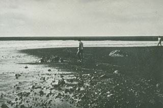 Ten days after a new island formed during a one-day submarine eruption in 1971, scientists investigate the surface of the new land. Ash plumes had been ejected to a height of 1 km. A low island 70 x 200 m had formed, with its block-littered surface one meter above high tide level. The Karua submarine volcano was constructed within the 6 x 12 km Kuwae caldera.
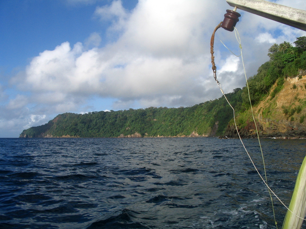
 The forested cliff marks the upper caldera wall of the largely-submarine Kuwae caldera between Epi and Tongoa islands. The 6 x 12 km caldera contains two basins that cut the NW end of Tongoa Island and the flank of the late-Pleistocene or Holocene Tavani Ruru volcano on the SE tip of Epi Island. The Karua volcano lies near the northern rim of the caldera. It has formed several ephemeral islands since it was first observed in eruption during 1897.
There are no samples for Kuwae in the Smithsonian's NMNH Department of Mineral Sciences Rock and Ore collection.
| Copernicus Browser | The Copernicus Browser replaced the Sentinel Hub Playground browser in 2023, to provide access to Earth observation archives from the Copernicus Data Space Ecosystem, the main distribution platform for data from the EU Copernicus missions. |
| MIROVA | Middle InfraRed Observation of Volcanic Activity (MIROVA) is a near real time volcanic hot-spot detection system based on the analysis of MODIS (Moderate Resolution Imaging Spectroradiometer) data. In particular, MIROVA uses the Middle InfraRed Radiation (MIR), measured over target volcanoes, in order to detect, locate and measure the heat radiation sourced from volcanic activity. |
| MODVOLC Thermal Alerts | Using infrared satellite Moderate Resolution Imaging Spectroradiometer (MODIS) data, scientists at the Hawai'i Institute of Geophysics and Planetology, University of Hawai'i, developed an automated system called MODVOLC to map thermal hot-spots in near real time. For each MODIS image, the algorithm automatically scans each 1 km pixel within it to check for high-temperature hot-spots. When one is found the date, time, location, and intensity are recorded. MODIS looks at every square km of the Earth every 48 hours, once during the day and once during the night, and the presence of two MODIS sensors in space allows at least four hot-spot observations every two days. Each day updated global maps are compiled to display the locations of all hot spots detected in the previous 24 hours. There is a drop-down list with volcano names which allow users to 'zoom-in' and examine the distribution of hot-spots at a variety of spatial scales. |
|
WOVOdat
Single Volcano View Temporal Evolution of Unrest Side by Side Volcanoes |
WOVOdat is a database of volcanic unrest; instrumentally and visually recorded changes in seismicity, ground deformation, gas emission, and other parameters from their normal baselines. It is sponsored by the World Organization of Volcano Observatories (WOVO) and presently hosted at the Earth Observatory of Singapore.
GVMID Data on Volcano Monitoring Infrastructure The Global Volcano Monitoring Infrastructure Database GVMID, is aimed at documenting and improving capabilities of volcano monitoring from the ground and space. GVMID should provide a snapshot and baseline view of the techniques and instrumentation that are in place at various volcanoes, which can be use by volcano observatories as reference to setup new monitoring system or improving networks at a specific volcano. These data will allow identification of what monitoring gaps exist, which can be then targeted by remote sensing infrastructure and future instrument deployments. |
| Volcanic Hazard Maps | The IAVCEI Commission on Volcanic Hazards and Risk has a Volcanic Hazard Maps database designed to serve as a resource for hazard mappers (or other interested parties) to explore how common issues in hazard map development have been addressed at different volcanoes, in different countries, for different hazards, and for different intended audiences. In addition to the comprehensive, searchable Volcanic Hazard Maps Database, this website contains information about diversity of volcanic hazard maps, illustrated using examples from the database. This site is for educational purposes related to volcanic hazard maps. Hazard maps found on this website should not be used for emergency purposes. For the most recent, official hazard map for a particular volcano, please seek out the proper institutional authorities on the matter. |
| IRIS seismic stations/networks | Incorporated Research Institutions for Seismology (IRIS) Data Services map showing the location of seismic stations from all available networks (permanent or temporary) within a radius of 0.18° (about 20 km at mid-latitudes) from the given location of Kuwae. Users can customize a variety of filters and options in the left panel. Note that if there are no stations are known the map will default to show the entire world with a "No data matched request" error notice. |
| UNAVCO GPS/GNSS stations | Geodetic Data Services map from UNAVCO showing the location of GPS/GNSS stations from all available networks (permanent or temporary) within a radius of 20 km from the given location of Kuwae. Users can customize the data search based on station or network names, location, and time window. Requires Adobe Flash Player. |
| DECADE Data | The DECADE portal, still in the developmental stage, serves as an example of the proposed interoperability between The Smithsonian Institution's Global Volcanism Program, the Mapping Gas Emissions (MaGa) Database, and the EarthChem Geochemical Portal. The Deep Earth Carbon Degassing (DECADE) initiative seeks to use new and established technologies to determine accurate global fluxes of volcanic CO2 to the atmosphere, but installing CO2 monitoring networks on 20 of the world's 150 most actively degassing volcanoes. The group uses related laboratory-based studies (direct gas sampling and analysis, melt inclusions) to provide new data for direct degassing of deep earth carbon to the atmosphere. |
| Large Eruptions of Kuwae | Information about large Quaternary eruptions (VEI >= 4) is cataloged in the Large Magnitude Explosive Volcanic Eruptions (LaMEVE) database of the Volcano Global Risk Identification and Analysis Project (VOGRIPA). |
| EarthChem | EarthChem develops and maintains databases, software, and services that support the preservation, discovery, access and analysis of geochemical data, and facilitate their integration with the broad array of other available earth science parameters. EarthChem is operated by a joint team of disciplinary scientists, data scientists, data managers and information technology developers who are part of the NSF-funded data facility Integrated Earth Data Applications (IEDA). IEDA is a collaborative effort of EarthChem and the Marine Geoscience Data System (MGDS). |

