CVGHM reported that, although weather conditions often prevented observations of Lamongan during 9 March-17 April, white plumes were occasionally seen rising 10-20 m above the crater rim. Seismicity decreased during this period. CVGHM lowered the Alert Level to 1 (on a scale of 1-4) on 19 April.
Source: Pusat Vulkanologi dan Mitigasi Bencana Geologi (PVMBG, also known as CVGHM)
Steep increase in seismicity during February-March 2012
According to the Center of Volcanology and Geological Hazard Mitigation (CVGHM), Lamongan has not erupted since 1898. On several occasions since then, however, seismic activity has increased. Brief periods of earthquakes and earthquake swarms occurred in 1924-25, 1978, 1985, and 1988 (SEAN 10:10, 10:11, 13:02). The Darwin Volcanic Ash Advisory Centre (VAAC) reported on 24 September 2003 that aircraft personnel had observed ash over the volcano to a height of about 900 m, but this was not confirmed by on-scene observers (BGVN 28:12). Our previous report noted continuous tremor and an earthquake swarm on 5-6 January 2005 (BGVN 31:01).
CVGHM reported that during 1 February-9 March 2012, diffuse white plumes rose at most 20 m above Lamongan's crater. Seismicity increased on 23 February, then fluctuated in intensity through 7 March. Seismicity increased significantly on 8-9 March (table 1). CVGHM raised the Alert Level to 2 (on a scale of 1-4) on 9 March, and began to monitor the volcano more intensively. Residents and tourists were prohibited from going within a 1-km-radius of the active crater. No eruptions occurred during the reporting period. Increased seismic activity at Lamongan continued at least through 12 March.
Table 1. Seismicity at Lamongan during 1 January-9 March 2012. Data from CVGHM. Shallow volcanic earthquakes were not reported and categories were not defined in the reports.
| Date (2012) | Deep Volcanic | Distant Tectonic | Local Tectonic |
| January | 2 | 16 | -- |
| 1-22 February | 1 | 15 | na |
| 23-29 February | 69 | 7 | 1 |
| 1-7 March | 77 | 6 | 7 |
| 8 March (0000-1200 hours) | 135 | -- | -- |
| 9 March (0000-1100 hours, continuous tremor) | -- | -- | 131 |
Information Contacts: Center of Volcanology and Geological Hazard Mitigation (CVGHM), Jalan Diponegoro 57, Bandung 40122, Indonesia (URL: http://www.vsi.esdm.go.id/); Darwin Volcanic Ash Advisory Centre (VAAC), Bureau of Meteorology, Northern Territory Regional Office, PO Box 40050, Casuarina, NT 0811, Australia (URL: http://www.bom.gov.au/info/vaac/).
2012: March
| April
2003: September
CVGHM reported that, although weather conditions often prevented observations of Lamongan during 9 March-17 April, white plumes were occasionally seen rising 10-20 m above the crater rim. Seismicity decreased during this period. CVGHM lowered the Alert Level to 1 (on a scale of 1-4) on 19 April.
Source: Pusat Vulkanologi dan Mitigasi Bencana Geologi (PVMBG, also known as CVGHM)
CVGHM reported that during 1 February-9 March diffuse white plumes rose at most 20 m above Lamongan. Seismicity increased on 23 February, then fluctuated in intensity through 7 March. Seismicity increased significantly on 8 March and tremor was recorded continuously the next day. CVGHM raised the Alert Level to 2 (on a scale of 1-4) on 9 March. Residents and tourists were prohibited from going within a 1-km-radius of the active crater.
Source: Pusat Vulkanologi dan Mitigasi Bencana Geologi (PVMBG, also known as CVGHM)
According to a report from aircraft personnel, on 24 September ash was visible rising to ~900 m above Lamongan. Ash was not visible on satellite imagery.
Source: Darwin Volcanic Ash Advisory Centre (VAAC)
Reports are organized chronologically and indexed below by Month/Year (Publication Volume:Number), and include a one-line summary. Click on the index link or scroll down to read the reports.
Seismic swarm near site of 1924-25 and 1978 swarms
"Lamongan experienced a seismic swarm with ground breakage 2-15 October. More than 3,000 earthquakes were recorded at the VSI observation post at Gunungmeja, near Klakah, W of Lamongan (figure 1). Two additional seismometers were installed in the epicentral area on 5-6 October. Ground breakage occurred in a region ~5 km W of the summit and consisting of numerous ground cracks, some with vertical offsets of 15 cm, striking ENE. No changes were noted in the temperatures or character of the many lakes in the Lamongan area, which fill maars created by prehistoric eruptions. The 1985 activity is in the same general area as two seismic swarms that occurred in 1924-25 and in 1978 but did not culminate in eruptions."
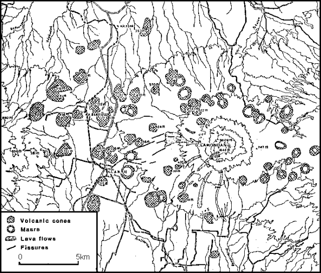 |
Figure 1. Map of Lamongan, after Van Bemmelen, 1949. Contour interval is 250 m. Contours on the W side of the map mark the lower E flank of Tengger Caldera. Fissures shown are from the 1924-25 earthquake swarm. |
"Lamongan was quite active during the 19th century with 40 eruptions, including more than a dozen that produced lava flows. Most were from vents located on the W flank above about 400 m altitude. It is notable that the maars on the W slope of Lamongan all occur at elevations below the historic eruption vents, suggesting that the position of the groundwater table controls its eruptive style. Eruptions from above 400 m altitude form fissure vents and cinder cones that pose little threat to the local inhabitants. Activity from vents below 400 m may give rise to explosive, maar-forming eruptions. The 1985 epicentral area has a surface elevation of 200-380 m. Plans are underway to increase the level of surveillance."
Reference. Van Bemmelen, R., 1949, The geology of Indonesia, v. 1B: M. Nijhoff, The Hague.
Information Contacts: J. Matahelumual, Suparto S., and T. Casadevall, VSI.
Seismicity declines
"November activity consisted of an average of one earthquake/day in the October swarm area W of the volcano. Detailed geological and monitoring efforts are now in progress by VSI to evaluate the possibility of a future eruption from the epicentral area."
Information Contacts: T. Casadevall and L. Pardyanto, VSI.
Increased seismicity but no temperature changes
A brief seismic swarm centered immediately W of Lamongan cone began on 8 February at 0445. Additional seismicity was recorded through February. No changes have been noted in the temperature or behavior of the maar lakes within the epicentral region. The earthquakes occurred in virtually the same epicentral area as those from the 1978 and 1985 swarms.
Information Contacts: VSI.
Pilot notes 24 September ash emission, but it lacks ground confirmation
When last discussed in 1988 (SEAN 13:02), a seismic swarm had occurred here. Except for an uncertain 1953 eruption, 20th- and 21st-century eruptions are unknown. Darwin Volcanic Ash Advisory 2003/1 notified aircraft personnel that, on 24 September 2003, ash was visible to ~ 900 m over Lamongan.
In this 2003 case, no confirmations of a plume or other signs of volcanism were available from observers on the scene. Concrete confirmations can establish that the plume did indeed vent here, rather than at another volcano and that it did not result from similar-looking processes of non-volcanic origin (eg., forest fires, crop burning, lofted dust).
Information Contacts: Darwin Volcanic Ash Advisory Centre (VAAC), Bureau of Meteorology, Northern Territory Regional Office, PO Box 40050, Casuarina, NT 0811, Australia (URL: http://www.bom.gov.au/info/vaac/).
Above-background seismicity during 5-6 January 2005
Elevated seismicity occurred at Lamongan on 5-6 January 2005. From 1200 to 0700 on 5 January, 22 events occurred with Modified Mercali Intensity (MMI) of 1. At each of three times (0331, 0447, and 0524) observers noted an event of MMI 3. During this period, instruments detected continuous tremor with an amplitude of 3 to 15 mm. On 5 January there were 282 local tectonic earthquakes and 53 volcanic A-type earthquakes. The volcano alert level was raised to 2.
On 6 January 2005, 107 volcanic A-type earthquakes were recorded. Local tectonic earthquakes over the two day period occurred 159 times, of which 10 of them were events had Modified Mercali Intensity (MMI) of 1-3.
Information Contacts: Darwin Volcanic Ash Advisory Centre (VAAC), Bureau of Meteorology, Northern Territory Regional Office, PO Box 40050, Casuarina, NT 0811, Australia (URL: http://www.bom.gov.au/info/vaac/).
Steep increase in seismicity during February-March 2012
According to the Center of Volcanology and Geological Hazard Mitigation (CVGHM), Lamongan has not erupted since 1898. On several occasions since then, however, seismic activity has increased. Brief periods of earthquakes and earthquake swarms occurred in 1924-25, 1978, 1985, and 1988 (SEAN 10:10, 10:11, 13:02). The Darwin Volcanic Ash Advisory Centre (VAAC) reported on 24 September 2003 that aircraft personnel had observed ash over the volcano to a height of about 900 m, but this was not confirmed by on-scene observers (BGVN 28:12). Our previous report noted continuous tremor and an earthquake swarm on 5-6 January 2005 (BGVN 31:01).
CVGHM reported that during 1 February-9 March 2012, diffuse white plumes rose at most 20 m above Lamongan's crater. Seismicity increased on 23 February, then fluctuated in intensity through 7 March. Seismicity increased significantly on 8-9 March (table 1). CVGHM raised the Alert Level to 2 (on a scale of 1-4) on 9 March, and began to monitor the volcano more intensively. Residents and tourists were prohibited from going within a 1-km-radius of the active crater. No eruptions occurred during the reporting period. Increased seismic activity at Lamongan continued at least through 12 March.
Table 1. Seismicity at Lamongan during 1 January-9 March 2012. Data from CVGHM. Shallow volcanic earthquakes were not reported and categories were not defined in the reports.
| Date (2012) | Deep Volcanic | Distant Tectonic | Local Tectonic |
| January | 2 | 16 | -- |
| 1-22 February | 1 | 15 | na |
| 23-29 February | 69 | 7 | 1 |
| 1-7 March | 77 | 6 | 7 |
| 8 March (0000-1200 hours) | 135 | -- | -- |
| 9 March (0000-1100 hours, continuous tremor) | -- | -- | 131 |
Information Contacts: Center of Volcanology and Geological Hazard Mitigation (CVGHM), Jalan Diponegoro 57, Bandung 40122, Indonesia (URL: http://www.vsi.esdm.go.id/); Darwin Volcanic Ash Advisory Centre (VAAC), Bureau of Meteorology, Northern Territory Regional Office, PO Box 40050, Casuarina, NT 0811, Australia (URL: http://www.bom.gov.au/info/vaac/).
|
|
||||||||||||||||||||||||||||
There is data available for 41 confirmed eruptive periods.
[ 1953 Apr 4 - 1953 Jun 16 ± 15 days ] Uncertain Eruption
| Episode 1 | Eruption (Explosive / Effusive) | ||||||||||||||||||||||||
|---|---|---|---|---|---|---|---|---|---|---|---|---|---|---|---|---|---|---|---|---|---|---|---|---|
| 1953 Apr 4 - 1953 Jun 16 ± 15 days | Evidence from Unknown | |||||||||||||||||||||||
|
List of 3 Events for Episode 1
|
||||||||||||||||||||||||
1898 Feb 5 - 1898 Feb 15 Confirmed Eruption (Explosive / Effusive) VEI: 2
| Episode 1 | Eruption (Explosive / Effusive) | SW flank 400 m (Mt. Anyar) | |||||||||||||||||||||||||||||||||||||||||||||||||||||
|---|---|---|---|---|---|---|---|---|---|---|---|---|---|---|---|---|---|---|---|---|---|---|---|---|---|---|---|---|---|---|---|---|---|---|---|---|---|---|---|---|---|---|---|---|---|---|---|---|---|---|---|---|---|---|
| 1898 Feb 5 - 1898 Feb 15 | Evidence from Observations: Reported | |||||||||||||||||||||||||||||||||||||||||||||||||||||
|
List of 9 Events for Episode 1 at SW flank 400 m (Mt. Anyar)
|
||||||||||||||||||||||||||||||||||||||||||||||||||||||
1896 Sep 5 - 1896 Sep 19 (on or after) Confirmed Eruption (Explosive / Effusive) VEI: 2
| Episode 1 | Eruption (Explosive / Effusive) | ||||||||||||||||||||||||
|---|---|---|---|---|---|---|---|---|---|---|---|---|---|---|---|---|---|---|---|---|---|---|---|---|
| 1896 Sep 5 - 1896 Sep 19 (on or after) | Evidence from Observations: Reported | |||||||||||||||||||||||
|
List of 3 Events for Episode 1
|
||||||||||||||||||||||||
1893 Nov 18 Confirmed Eruption (Explosive / Effusive) VEI: 2
| Episode 1 | Eruption (Explosive / Effusive) | |||||||||||||||||||||||||||||
|---|---|---|---|---|---|---|---|---|---|---|---|---|---|---|---|---|---|---|---|---|---|---|---|---|---|---|---|---|---|
| 1893 Nov 18 - Unknown | Evidence from Observations: Reported | ||||||||||||||||||||||||||||
|
List of 4 Events for Episode 1
|
|||||||||||||||||||||||||||||
1891 Sep 25 ± 5 days - 1891 Oct 5 ± 4 days Confirmed Eruption (Explosive / Effusive) VEI: 2
| Episode 1 | Eruption (Explosive / Effusive) | ||||||||||||||||||||||||
|---|---|---|---|---|---|---|---|---|---|---|---|---|---|---|---|---|---|---|---|---|---|---|---|---|
| 1891 Sep 25 ± 5 days - 1891 Oct 5 ± 4 days | Evidence from Observations: Reported | |||||||||||||||||||||||
|
List of 3 Events for Episode 1
|
||||||||||||||||||||||||
1890 Sep 5 ± 4 days - 1891 Jan (on or after) Confirmed Eruption (Explosive / Effusive) VEI: 2
| Episode 1 | Eruption (Explosive / Effusive) | ||||||||||||||||||||||||
|---|---|---|---|---|---|---|---|---|---|---|---|---|---|---|---|---|---|---|---|---|---|---|---|---|
| 1890 Sep 5 ± 4 days - 1891 Jan (on or after) | Evidence from Observations: Reported | |||||||||||||||||||||||
|
List of 3 Events for Episode 1
|
||||||||||||||||||||||||
1890 Mar 23 ± 8 days - 1890 May Confirmed Eruption (Explosive / Effusive) VEI: 2
| Episode 1 | Eruption (Explosive / Effusive) | |||||||||||||||||||
|---|---|---|---|---|---|---|---|---|---|---|---|---|---|---|---|---|---|---|---|
| 1890 Mar 23 ± 8 days - 1890 May | Evidence from Observations: Reported | ||||||||||||||||||
|
List of 2 Events for Episode 1
|
|||||||||||||||||||
1889 Sep 7 - 1889 Nov Confirmed Eruption (Explosive / Effusive) VEI: 2
| Episode 1 | Eruption (Explosive / Effusive) | ||||||||||||||||||||||||
|---|---|---|---|---|---|---|---|---|---|---|---|---|---|---|---|---|---|---|---|---|---|---|---|---|
| 1889 Sep 7 - 1889 Nov | Evidence from Observations: Reported | |||||||||||||||||||||||
|
List of 3 Events for Episode 1
|
||||||||||||||||||||||||
1888 Sep - 1888 Oct 6 Confirmed Eruption (Explosive / Effusive) VEI: 2
| Episode 1 | Eruption (Explosive / Effusive) | ||||||||||||||||||||||||
|---|---|---|---|---|---|---|---|---|---|---|---|---|---|---|---|---|---|---|---|---|---|---|---|---|
| 1888 Sep - 1888 Oct 6 | Evidence from Observations: Reported | |||||||||||||||||||||||
|
List of 3 Events for Episode 1
|
||||||||||||||||||||||||
1887 Nov - 1888 Feb 27 Confirmed Eruption (Explosive / Effusive) VEI: 2
| Episode 1 | Eruption (Explosive / Effusive) | |||||||||||||||||||
|---|---|---|---|---|---|---|---|---|---|---|---|---|---|---|---|---|---|---|---|
| 1887 Nov - 1888 Feb 27 | Evidence from Observations: Reported | ||||||||||||||||||
|
List of 2 Events for Episode 1
|
|||||||||||||||||||
1887 Jul 3 ± 1 days - 1887 Jul 9 Confirmed Eruption (Explosive / Effusive) VEI: 2
| Episode 1 | Eruption (Explosive / Effusive) | ||||||||||||||||||||||||
|---|---|---|---|---|---|---|---|---|---|---|---|---|---|---|---|---|---|---|---|---|---|---|---|---|
| 1887 Jul 3 ± 1 days - 1887 Jul 9 | Evidence from Observations: Reported | |||||||||||||||||||||||
|
List of 3 Events for Episode 1
|
||||||||||||||||||||||||
1885 Mar 11 - 1886 Oct 15 ± 5 days Confirmed Eruption (Explosive / Effusive) VEI: 2
| Episode 1 | Eruption (Explosive / Effusive) | |||||||||||||||||||||||||||||||||||||||
|---|---|---|---|---|---|---|---|---|---|---|---|---|---|---|---|---|---|---|---|---|---|---|---|---|---|---|---|---|---|---|---|---|---|---|---|---|---|---|---|
| 1885 Mar 11 - 1886 Oct 15 ± 5 days | Evidence from Observations: Reported | ||||||||||||||||||||||||||||||||||||||
|
List of 6 Events for Episode 1
|
|||||||||||||||||||||||||||||||||||||||
1884 Jan 6 - 1884 Jun 23 Confirmed Eruption (Explosive / Effusive) VEI: 2
| Episode 1 | Eruption (Explosive / Effusive) | |||||||||||||||||||
|---|---|---|---|---|---|---|---|---|---|---|---|---|---|---|---|---|---|---|---|
| 1884 Jan 6 - 1884 Jun 23 | Evidence from Observations: Reported | ||||||||||||||||||
|
List of 2 Events for Episode 1
|
|||||||||||||||||||
1883 Apr 13 - 1883 May 4 ± 1 days Confirmed Eruption (Explosive / Effusive) VEI: 2
| Episode 1 | Eruption (Explosive / Effusive) | |||||||||||||||||||||||||||||
|---|---|---|---|---|---|---|---|---|---|---|---|---|---|---|---|---|---|---|---|---|---|---|---|---|---|---|---|---|---|
| 1883 Apr 13 - 1883 May 4 ± 1 days | Evidence from Observations: Reported | ||||||||||||||||||||||||||||
|
List of 4 Events for Episode 1
|
|||||||||||||||||||||||||||||
1877 Apr 24 (?) - 1877 May 12 (?) Confirmed Eruption (Explosive / Effusive) VEI: 3 (?)
| Episode 1 | Eruption (Explosive / Effusive) | |||||||||||||||||||||||||||||||||||||||
|---|---|---|---|---|---|---|---|---|---|---|---|---|---|---|---|---|---|---|---|---|---|---|---|---|---|---|---|---|---|---|---|---|---|---|---|---|---|---|---|
| 1877 Apr 24 (?) - 1877 May 12 (?) | Evidence from Observations: Reported | ||||||||||||||||||||||||||||||||||||||
|
List of 6 Events for Episode 1
|
|||||||||||||||||||||||||||||||||||||||
1874 May 20 - 1874 Aug 21 Confirmed Eruption (Explosive / Effusive) VEI: 2
| Episode 1 | Eruption (Explosive / Effusive) | ||||||||||||||||||||||||
|---|---|---|---|---|---|---|---|---|---|---|---|---|---|---|---|---|---|---|---|---|---|---|---|---|
| 1874 May 20 - 1874 Aug 21 | Evidence from Observations: Reported | |||||||||||||||||||||||
|
List of 3 Events for Episode 1
|
||||||||||||||||||||||||
1872 Aug 15 - 1872 Sep 18 Confirmed Eruption (Explosive / Effusive) VEI: 2
| Episode 1 | Eruption (Explosive / Effusive) | |||||||||||||||||||
|---|---|---|---|---|---|---|---|---|---|---|---|---|---|---|---|---|---|---|---|
| 1872 Aug 15 - 1872 Sep 18 | Evidence from Observations: Reported | ||||||||||||||||||
|
List of 2 Events for Episode 1
|
|||||||||||||||||||
1870 Aug 18 - 1871 Feb 5 ± 1 days Confirmed Eruption (Explosive / Effusive) VEI: 2
| Episode 1 | Eruption (Explosive / Effusive) | Summit and SW flank | ||||||||||||||||||||||||||||
|---|---|---|---|---|---|---|---|---|---|---|---|---|---|---|---|---|---|---|---|---|---|---|---|---|---|---|---|---|---|
| 1870 Aug 18 - 1871 Feb 5 ± 1 days | Evidence from Observations: Reported | ||||||||||||||||||||||||||||
|
List of 4 Events for Episode 1 at Summit and SW flank
|
|||||||||||||||||||||||||||||
1870 Mar 2 - 1870 Mar 5 Confirmed Eruption (Explosive / Effusive) VEI: 2
| Episode 1 | Eruption (Explosive / Effusive) | |||||||||||||||||||
|---|---|---|---|---|---|---|---|---|---|---|---|---|---|---|---|---|---|---|---|
| 1870 Mar 2 - 1870 Mar 5 | Evidence from Observations: Reported | ||||||||||||||||||
|
List of 2 Events for Episode 1
|
|||||||||||||||||||
1869 Sep 12 Confirmed Eruption (Explosive / Effusive) VEI: 2
| Episode 1 | Eruption (Explosive / Effusive) | |||||||||||||||||||||||||||||||||||||||
|---|---|---|---|---|---|---|---|---|---|---|---|---|---|---|---|---|---|---|---|---|---|---|---|---|---|---|---|---|---|---|---|---|---|---|---|---|---|---|---|
| 1869 Sep 12 - Unknown | Evidence from Observations: Reported | ||||||||||||||||||||||||||||||||||||||
|
List of 6 Events for Episode 1
|
|||||||||||||||||||||||||||||||||||||||
1869 Apr 6 - 1869 May 4 Confirmed Eruption (Explosive / Effusive) VEI: 2
| Episode 1 | Eruption (Explosive / Effusive) | Summit and south slope | |||||||||||||||||||||||||||||||||
|---|---|---|---|---|---|---|---|---|---|---|---|---|---|---|---|---|---|---|---|---|---|---|---|---|---|---|---|---|---|---|---|---|---|---|
| 1869 Apr 6 - 1869 May 4 | Evidence from Observations: Reported | |||||||||||||||||||||||||||||||||
|
List of 5 Events for Episode 1 at Summit and south slope
|
||||||||||||||||||||||||||||||||||
1864 Jun 9 - 1864 Jul Confirmed Eruption (Explosive / Effusive) VEI: 2
| Episode 1 | Eruption (Explosive / Effusive) | |||||||||||||||||||||||||||||
|---|---|---|---|---|---|---|---|---|---|---|---|---|---|---|---|---|---|---|---|---|---|---|---|---|---|---|---|---|---|
| 1864 Jun 9 - 1864 Jul | Evidence from Observations: Reported | ||||||||||||||||||||||||||||
|
List of 4 Events for Episode 1
|
|||||||||||||||||||||||||||||
1861 Confirmed Eruption (Explosive / Effusive) VEI: 2
| Episode 1 | Eruption (Explosive / Effusive) | |||||||||||||||||||
|---|---|---|---|---|---|---|---|---|---|---|---|---|---|---|---|---|---|---|---|
| 1861 - Unknown | Evidence from Observations: Reported | ||||||||||||||||||
|
List of 2 Events for Episode 1
|
|||||||||||||||||||
1859 Feb 27 - 1859 Mar Confirmed Eruption (Explosive / Effusive) VEI: 2
| Episode 1 | Eruption (Explosive / Effusive) | |||||||||||||||||||||||||||||
|---|---|---|---|---|---|---|---|---|---|---|---|---|---|---|---|---|---|---|---|---|---|---|---|---|---|---|---|---|---|
| 1859 Feb 27 - 1859 Mar | Evidence from Observations: Reported | ||||||||||||||||||||||||||||
|
List of 4 Events for Episode 1
|
|||||||||||||||||||||||||||||
1856 Mar 1 - 1856 Jun 14 Confirmed Eruption (Explosive / Effusive) VEI: 2
| Episode 1 | Eruption (Explosive / Effusive) | |||||||||||||||||||
|---|---|---|---|---|---|---|---|---|---|---|---|---|---|---|---|---|---|---|---|
| 1856 Mar 1 - 1856 Jun 14 | Evidence from Observations: Reported | ||||||||||||||||||
|
List of 2 Events for Episode 1
|
|||||||||||||||||||
1849 Jun - 1849 Sep Confirmed Eruption (Explosive / Effusive) VEI: 2
| Episode 1 | Eruption (Explosive / Effusive) | Summit and north flank | ||||||||||||||||||||||||||||
|---|---|---|---|---|---|---|---|---|---|---|---|---|---|---|---|---|---|---|---|---|---|---|---|---|---|---|---|---|---|
| 1849 Jun - 1849 Sep | Evidence from Observations: Reported | ||||||||||||||||||||||||||||
|
List of 4 Events for Episode 1 at Summit and north flank
|
|||||||||||||||||||||||||||||
1847 Sep 25 Confirmed Eruption (Explosive / Effusive) VEI: 2
| Episode 1 | Eruption (Explosive / Effusive) | ||||||||||||||||||||||||
|---|---|---|---|---|---|---|---|---|---|---|---|---|---|---|---|---|---|---|---|---|---|---|---|---|
| 1847 Sep 25 - Unknown | Evidence from Observations: Reported | |||||||||||||||||||||||
|
List of 3 Events for Episode 1
|
||||||||||||||||||||||||
1847 Mar 26 - 1847 Jun 26 Confirmed Eruption (Explosive / Effusive) VEI: 2
| Episode 1 | Eruption (Explosive / Effusive) | ||||||||||||||||||||||||||||||||||
|---|---|---|---|---|---|---|---|---|---|---|---|---|---|---|---|---|---|---|---|---|---|---|---|---|---|---|---|---|---|---|---|---|---|---|
| 1847 Mar 26 - 1847 Jun 26 | Evidence from Observations: Reported | |||||||||||||||||||||||||||||||||
|
List of 5 Events for Episode 1
|
||||||||||||||||||||||||||||||||||
1843 Aug - 1844 Sep Confirmed Eruption (Explosive / Effusive) VEI: 2
| Episode 1 | Eruption (Explosive / Effusive) | ||||||||||||||||||||||||||||||||||
|---|---|---|---|---|---|---|---|---|---|---|---|---|---|---|---|---|---|---|---|---|---|---|---|---|---|---|---|---|---|---|---|---|---|---|
| 1843 Aug - 1844 Sep | Evidence from Observations: Reported | |||||||||||||||||||||||||||||||||
|
List of 5 Events for Episode 1
|
||||||||||||||||||||||||||||||||||
1841 Jul 16 - 1842 Aug Confirmed Eruption (Explosive / Effusive) VEI: 2
| Episode 1 | Eruption (Explosive / Effusive) | |||||||||||||||||||
|---|---|---|---|---|---|---|---|---|---|---|---|---|---|---|---|---|---|---|---|
| 1841 Jul 16 - 1842 Aug | Evidence from Observations: Reported | ||||||||||||||||||
|
List of 2 Events for Episode 1
|
|||||||||||||||||||
1838 Oct 18 Confirmed Eruption (Explosive / Effusive) VEI: 2
| Episode 1 | Eruption (Explosive / Effusive) | |||||||||||||||||||
|---|---|---|---|---|---|---|---|---|---|---|---|---|---|---|---|---|---|---|---|
| 1838 Oct 18 - Unknown | Evidence from Observations: Reported | ||||||||||||||||||
|
List of 2 Events for Episode 1
|
|||||||||||||||||||
1838 Jul 4 - 1838 Jul 6 Confirmed Eruption (Explosive / Effusive) VEI: 2
| Episode 1 | Eruption (Explosive / Effusive) | |||||||||||||||||||
|---|---|---|---|---|---|---|---|---|---|---|---|---|---|---|---|---|---|---|---|
| 1838 Jul 4 - 1838 Jul 6 | Evidence from Observations: Reported | ||||||||||||||||||
|
List of 2 Events for Episode 1
|
|||||||||||||||||||
1830 Feb - 1830 Mar Confirmed Eruption (Explosive / Effusive) VEI: 2
| Episode 1 | Eruption (Explosive / Effusive) | ||||||||||||||||||||||||
|---|---|---|---|---|---|---|---|---|---|---|---|---|---|---|---|---|---|---|---|---|---|---|---|---|
| 1830 Feb - 1830 Mar | Evidence from Observations: Reported | |||||||||||||||||||||||
|
List of 3 Events for Episode 1
|
||||||||||||||||||||||||
1829 Jan - 1829 Feb Confirmed Eruption (Explosive / Effusive) VEI: 2
| Episode 1 | Eruption (Explosive / Effusive) | ||||||||||||||||||||||||
|---|---|---|---|---|---|---|---|---|---|---|---|---|---|---|---|---|---|---|---|---|---|---|---|---|
| 1829 Jan - 1829 Feb | Evidence from Observations: Reported | |||||||||||||||||||||||
|
List of 3 Events for Episode 1
|
||||||||||||||||||||||||
1826 Confirmed Eruption (Explosive / Effusive) VEI: 2
| Episode 1 | Eruption (Explosive / Effusive) | |||||||||||||||||||
|---|---|---|---|---|---|---|---|---|---|---|---|---|---|---|---|---|---|---|---|
| 1826 - Unknown | Evidence from Observations: Reported | ||||||||||||||||||
|
List of 2 Events for Episode 1
|
|||||||||||||||||||
1824 Jan 1 (?) - 1824 Jan 31 (?) Confirmed Eruption (Explosive / Effusive) VEI: 2
| Episode 1 | Eruption (Explosive / Effusive) | ||||||||||||||||||||||||
|---|---|---|---|---|---|---|---|---|---|---|---|---|---|---|---|---|---|---|---|---|---|---|---|---|
| 1824 Jan 1 (?) - 1824 Jan 31 (?) | Evidence from Observations: Reported | |||||||||||||||||||||||
|
List of 3 Events for Episode 1
|
||||||||||||||||||||||||
1821 Dec 15 ± 5 days - 1822 Jan 5 Confirmed Eruption (Explosive / Effusive) VEI: 2
| Episode 1 | Eruption (Explosive / Effusive) | ||||||||||||||||||||||||
|---|---|---|---|---|---|---|---|---|---|---|---|---|---|---|---|---|---|---|---|---|---|---|---|---|
| 1821 Dec 15 ± 5 days - 1822 Jan 5 | Evidence from Observations: Reported | |||||||||||||||||||||||
|
List of 3 Events for Episode 1
|
||||||||||||||||||||||||
1818 Oct 8 Confirmed Eruption (Explosive / Effusive) VEI: 2
| Episode 1 | Eruption (Explosive / Effusive) | |||||||||||||||||||
|---|---|---|---|---|---|---|---|---|---|---|---|---|---|---|---|---|---|---|---|
| 1818 Oct 8 - Unknown | Evidence from Observations: Reported | ||||||||||||||||||
|
List of 2 Events for Episode 1
|
|||||||||||||||||||
1817 Confirmed Eruption (Explosive / Effusive) VEI: 2
| Episode 1 | Eruption (Explosive / Effusive) | |||||||||||||||||||
|---|---|---|---|---|---|---|---|---|---|---|---|---|---|---|---|---|---|---|---|
| 1817 - Unknown | Evidence from Observations: Reported | ||||||||||||||||||
|
List of 2 Events for Episode 1
|
|||||||||||||||||||
1808 Dec 8 Confirmed Eruption (Explosive / Effusive) VEI: 2
| Episode 1 | Eruption (Explosive / Effusive) | |||||||||||||||||||
|---|---|---|---|---|---|---|---|---|---|---|---|---|---|---|---|---|---|---|---|
| 1808 Dec 8 - Unknown | Evidence from Observations: Reported | ||||||||||||||||||
|
List of 2 Events for Episode 1
|
|||||||||||||||||||
1806 May Confirmed Eruption (Explosive / Effusive) VEI: 2
| Episode 1 | Eruption (Explosive / Effusive) | ||||||||||||||||||||||||||||||||||
|---|---|---|---|---|---|---|---|---|---|---|---|---|---|---|---|---|---|---|---|---|---|---|---|---|---|---|---|---|---|---|---|---|---|---|
| 1806 May - Unknown | Evidence from Observations: Reported | |||||||||||||||||||||||||||||||||
|
List of 5 Events for Episode 1
|
||||||||||||||||||||||||||||||||||
1799 Confirmed Eruption (Explosive / Effusive) VEI: 2
| Episode 1 | Eruption (Explosive / Effusive) | |||||||||||||||||||
|---|---|---|---|---|---|---|---|---|---|---|---|---|---|---|---|---|---|---|---|
| 1799 - Unknown | Evidence from Observations: Reported | ||||||||||||||||||
|
List of 2 Events for Episode 1
|
|||||||||||||||||||
This compilation of synonyms and subsidiary features may not be comprehensive. Features are organized into four major categories: Cones, Craters, Domes, and Thermal Features. Synonyms of features appear indented below the primary name. In some cases additional feature type, elevation, or location details are provided.
Synonyms |
||||
| Lemongan | ||||
Cones |
||||
| Feature Name | Feature Type | Elevation | Latitude | Longitude |
| Anyar, Gunung | Cone | 400 m | 7° 59' 40.00" S | 113° 18' 29.00" E |
| Geni, Gunung | Cone | |||
| Lamongan, Gunung | Stratovolcano | 1607 m | 7° 58' 46.00" S | 113° 20' 33.00" E |
| Tarub
Taroeb |
Stratovolcano | 1641 m | 7° 58' 32.00" S | 113° 20' 48.00" E |
| Tjupu, Gunung
Gunung Cupu |
Cone | 800 m | ||
Craters |
||||
| Feature Name | Feature Type | Elevation | Latitude | Longitude |
| Bedali, Ranu | Maar | |||
| Klakah, Ranu | Maar | |||
| Pakis, Ranu | Maar | |||
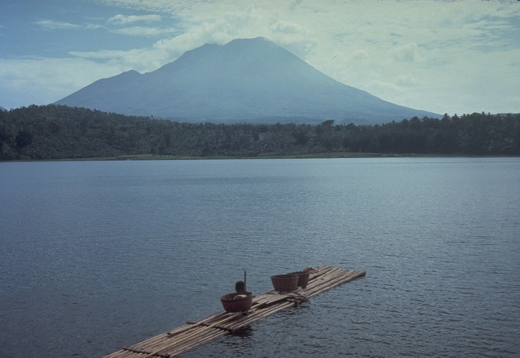
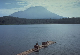 Lamongan, a small volcano located between the massive Tengger and Iyang-Argapura volcanoes, rises above Lamongan Lake on its western flank. Ranu Lamongan lake fills one of 27 maars that surround the volcano, that have diameters ranging from 150 to 700 m. There have been frequent explosive eruptions, mostly from the summit crater, during the 19th century.
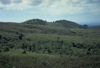 The Gunung Anyar scoria cones were formed during an eruption in 1898 at 400 m elevation on the SW flank of Lamongan. The eruption began on 5 February. Activity slowed by the 7th, but the emission of two small lava flows continued, the largest of which traveled 300 m by the time it stopped on 15 February.
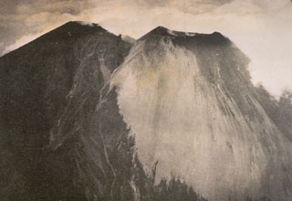 A view of Lamongan volcano from the west shows the forested summit of Gunung Tarub, forming the highest point on the volcano to the left, with a younger, sparsely vegetated cone (Gunung Lamongan) constructed to the SW. A volcanic spine was located in the summit crater, which has been the source of most historical eruptions.
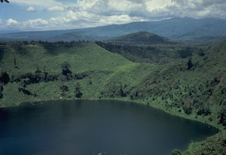 This lake-filled maar on the NE flank of Lamongan is one of 27 surrounding the volcano. Most historical eruptions have originated from the summit crater.
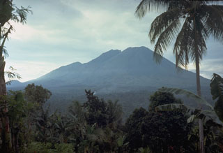 Lamongan volcano is located between the Tengger and Iyang-Argapura volcanic complexes. A cluster of 27 maars, many filled by lakes, and 37 scoria cones surround the volcano. Tarub is the volcano's highest peak to the left. Lamongan was frequently active during the 19th century, producing both explosive eruptions and lava flows.
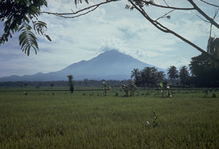 Lamongan volcano is located between the Tengger and Iyang-Argapura volcanic complexes. A cluster of 27 maars, many filled by lakes, and 37 scoria cones surround the volcano. Tarub is the volcano's highest peak to the left. Lamongan was frequently active during the 19th century, producing both explosive eruptions and lava flows.
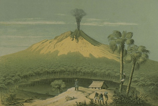 This sketch from the west, published during the mid-19th century, depicts one of the several 19th-century eruptions that produced both explosive activity and lava flow emission from the summit crater. One of the many lake-filled maars surrounding the volcano is seen in the foreground.
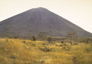 The sparsely vegetated slopes of Gunung Lamongan rise above grasslands at the western flank of the volcano.
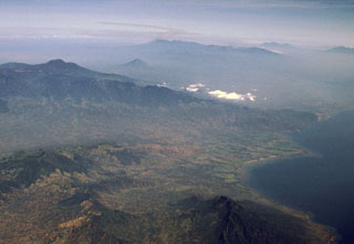 The small Lurus volcanic complex (middle right) lies along the northern coast of eastern Java, below and to the right of the low clouds at the right-center. Lurus lies N of the Iyang-Argapura massif, the broad volcanic complex covering much of the left center of this aerial view from the NE. The conical volcano beyond Iyang-Argapura is Lamongan volcano, and the Tengger-Semeru massif lies along the center of the horizon. The triple-peaked volcano on the right horizon is Kawi-Butak.
There are no samples for Lamongan in the Smithsonian's NMNH Department of Mineral Sciences Rock and Ore collection.
| Copernicus Browser | The Copernicus Browser replaced the Sentinel Hub Playground browser in 2023, to provide access to Earth observation archives from the Copernicus Data Space Ecosystem, the main distribution platform for data from the EU Copernicus missions. |
| MIROVA | Middle InfraRed Observation of Volcanic Activity (MIROVA) is a near real time volcanic hot-spot detection system based on the analysis of MODIS (Moderate Resolution Imaging Spectroradiometer) data. In particular, MIROVA uses the Middle InfraRed Radiation (MIR), measured over target volcanoes, in order to detect, locate and measure the heat radiation sourced from volcanic activity. |
| MODVOLC Thermal Alerts | Using infrared satellite Moderate Resolution Imaging Spectroradiometer (MODIS) data, scientists at the Hawai'i Institute of Geophysics and Planetology, University of Hawai'i, developed an automated system called MODVOLC to map thermal hot-spots in near real time. For each MODIS image, the algorithm automatically scans each 1 km pixel within it to check for high-temperature hot-spots. When one is found the date, time, location, and intensity are recorded. MODIS looks at every square km of the Earth every 48 hours, once during the day and once during the night, and the presence of two MODIS sensors in space allows at least four hot-spot observations every two days. Each day updated global maps are compiled to display the locations of all hot spots detected in the previous 24 hours. There is a drop-down list with volcano names which allow users to 'zoom-in' and examine the distribution of hot-spots at a variety of spatial scales. |
|
WOVOdat
Single Volcano View Temporal Evolution of Unrest Side by Side Volcanoes |
WOVOdat is a database of volcanic unrest; instrumentally and visually recorded changes in seismicity, ground deformation, gas emission, and other parameters from their normal baselines. It is sponsored by the World Organization of Volcano Observatories (WOVO) and presently hosted at the Earth Observatory of Singapore.
GVMID Data on Volcano Monitoring Infrastructure The Global Volcano Monitoring Infrastructure Database GVMID, is aimed at documenting and improving capabilities of volcano monitoring from the ground and space. GVMID should provide a snapshot and baseline view of the techniques and instrumentation that are in place at various volcanoes, which can be use by volcano observatories as reference to setup new monitoring system or improving networks at a specific volcano. These data will allow identification of what monitoring gaps exist, which can be then targeted by remote sensing infrastructure and future instrument deployments. |
| Volcanic Hazard Maps | The IAVCEI Commission on Volcanic Hazards and Risk has a Volcanic Hazard Maps database designed to serve as a resource for hazard mappers (or other interested parties) to explore how common issues in hazard map development have been addressed at different volcanoes, in different countries, for different hazards, and for different intended audiences. In addition to the comprehensive, searchable Volcanic Hazard Maps Database, this website contains information about diversity of volcanic hazard maps, illustrated using examples from the database. This site is for educational purposes related to volcanic hazard maps. Hazard maps found on this website should not be used for emergency purposes. For the most recent, official hazard map for a particular volcano, please seek out the proper institutional authorities on the matter. |
| IRIS seismic stations/networks | Incorporated Research Institutions for Seismology (IRIS) Data Services map showing the location of seismic stations from all available networks (permanent or temporary) within a radius of 0.18° (about 20 km at mid-latitudes) from the given location of Lamongan. Users can customize a variety of filters and options in the left panel. Note that if there are no stations are known the map will default to show the entire world with a "No data matched request" error notice. |
| UNAVCO GPS/GNSS stations | Geodetic Data Services map from UNAVCO showing the location of GPS/GNSS stations from all available networks (permanent or temporary) within a radius of 20 km from the given location of Lamongan. Users can customize the data search based on station or network names, location, and time window. Requires Adobe Flash Player. |
| DECADE Data | The DECADE portal, still in the developmental stage, serves as an example of the proposed interoperability between The Smithsonian Institution's Global Volcanism Program, the Mapping Gas Emissions (MaGa) Database, and the EarthChem Geochemical Portal. The Deep Earth Carbon Degassing (DECADE) initiative seeks to use new and established technologies to determine accurate global fluxes of volcanic CO2 to the atmosphere, but installing CO2 monitoring networks on 20 of the world's 150 most actively degassing volcanoes. The group uses related laboratory-based studies (direct gas sampling and analysis, melt inclusions) to provide new data for direct degassing of deep earth carbon to the atmosphere. |
| Large Eruptions of Lamongan | Information about large Quaternary eruptions (VEI >= 4) is cataloged in the Large Magnitude Explosive Volcanic Eruptions (LaMEVE) database of the Volcano Global Risk Identification and Analysis Project (VOGRIPA). |
| EarthChem | EarthChem develops and maintains databases, software, and services that support the preservation, discovery, access and analysis of geochemical data, and facilitate their integration with the broad array of other available earth science parameters. EarthChem is operated by a joint team of disciplinary scientists, data scientists, data managers and information technology developers who are part of the NSF-funded data facility Integrated Earth Data Applications (IEDA). IEDA is a collaborative effort of EarthChem and the Marine Geoscience Data System (MGDS). |

