Increased seismic activity in January
The monthly total of earthquakes for December was 397, and included volcanic tremors on 1, 2, and 28 December. In January, seismicity increased to a total of 2,142 events. From the night of 9 January through 11 January, activity peaked with a high of 1,262 events on 10 January, the highest daily number of recorded seismic events since 11 October 1995. The highest plumes reached 600 m in December and 700 m in January.
Information Contacts: Volcanological Division, Japan Meteorological Agency (JMA), 1-3-4 Ote-machi, Chiyoda-ku, Tokyo 100, Japan.
The Global Volcanism Program has no Weekly Reports available for Kujusan.
Reports are organized chronologically and indexed below by Month/Year (Publication Volume:Number), and include a one-line summary. Click on the index link or scroll down to read the reports.
Phreatic explosion on 11 October causes ashfall 60 km away
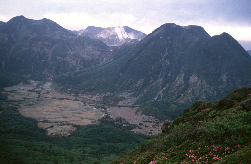
The observation of "smoke" in the Kuju Volcano Group (figure 1) near the Hosho dome (summit elevation 1,762 m, figure 2) at about 1800 on 11 October prompted the local meteorological observatory to issue a volcano alert. Ashfall from the phreatic activity was observed in towns as far as 60 km away, but there was no noticeable seismicity. When observed by the Kyushu Mobile Volcano Observation Team at 1430 on 12 September, steam was rising 400 m from around mid-slope on the dome. At that time there were three vents and fissure vents on the E slope of Hosho in an area ~300 m E-W by 100 m N-S. A photograph published in the Japan Times on 13 October (figure 3) showed steam emissions from numerous points along one ridge of the dome.
 |
Figure 1. Map of central and southern Kyushu Island, showing selected cities and historically active volcanoes. Courtesy of Tokiko Tiba. |
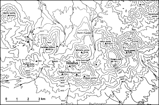 |
Figure 2. Map of the Kuju Volcano Group (modified from Kuno, 1962). Hosho Dome is near the center of the group. |
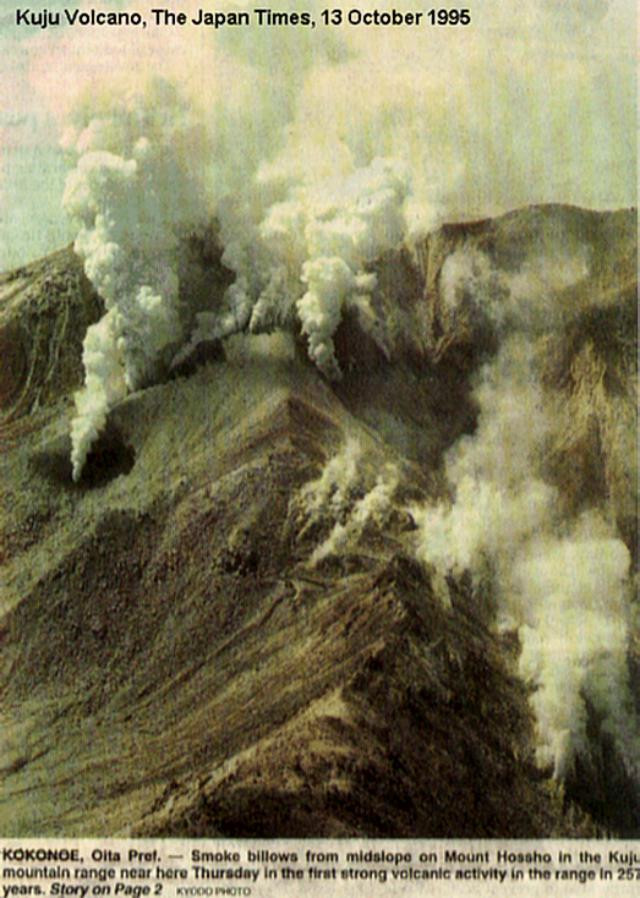 |
Figure 3. Photograph of steam emissions from the Hosho dome at Kuju. Scanned from a photograph published in the Japan Times, 13 October 1995. |
Reference. Kuno, H., 1962, Japan, Taiwan, and Marianas: Catalog of active volcanoes of the world, part 11, p. 54-57.
Information Contacts: Volcanological Division, Seismological and Volcanological Department, Japan Meteorological Agency (JMA), 1-3-4 Ote-machi, Chiyoda-ku, Tokyo 100 Japan; Tokiko Tiba, Department of Geology, National Science Museum, 3-23-1 Hyakunin-cho, Shinjuku-ku, Tokyo 169, Japan; The Japan Times, Tokyo, Japan.
Additional data on the sudden aseismic eruption of 11 October
On 11 October, aseismic phreatic eruptions started within the Kuju volcanic group, on Hosho (Hosyo) dome's E side (BGVN 20:09). On 12 October observers found an E-W trending line of vents ~300-m long; also, at that time an ash-bearing plume rose to ~1 km above the crater.
The eruption deposited a 100 m2 blanket of fist-sized volcanic clasts; it also emitted mud that flowed down an adjacent valley. After that, the volume and height of the plume gradually decreased until finally ash-bearing eruptions ceased at the month's end. Seismicity stayed low during October.
Information Contacts: Volcanological Division, Seismological and Volcanological Department, Japan Meteorological Agency (JMA), 1-3-4 Ote-machi, Chiyoda-ku, Tokyo 100 Japan.
Seismically active with occasional lapilli and steam ejections
An aseismic phreatic eruption vented from the N flank (not E as previously reported) of Hosho dome on the evening of 11 October (BGVN 20:10). The eruption came from a 400-m-long E-W fissure that includes multiple sub-fissures and craters.
The Volcano Research Center (VRC) at the University of Tokyo reported that the estimated volume of tephra from the 11 October eruption was 22,000 m3. Violent steaming from the vents and craters along en-echelon cracks has reportedly continued since then. An image taken by the French SPOT-2 satellite on the morning of 13 October shows an ash plume extending SW.
JMA reported that on 12 and 13 November field observers saw steam vigorously escaping from Vent D. The steam carried volcanic lapilli up to 5 cm in diameter.
Another JMA field party witnessed a loud explosion on 13 December, but ejecta were not found. VRC reported that another phreatic eruption on the morning of 18 December produced ~20% of the tephra of the 11 October eruption. Associated tremor, local deflation, and earthquakes were noted. Small ash emissions continued until at least as late as the night of 13 January 1996. In material erupted since 20 December, clear juvenile rhyolite glass shards were recognized in the ash and comprised roughly 1% of its volume.
The highest plumes during November and December rose ~300 and 600 m above the vent. On 23 November, earthquakes increased and the daily total was 13; the monthly total was 69. During the most active days in December, the 2nd and 18th, daily totals were 22 and 29, respectively; the total for the month was 134.
Further Reference. Hiroki, H., and Tatsuro, C., 1995, Eruption of Iozan at Kuju volcano in October 1995: Journal of the Geological Society of Japan, v. 101, no. 12, p. 43-56.
Information Contacts: Volcanological Division, Seismological and Volcanological Department, Japan Meteorological Agency (JMA), 1-3-4 Ote-machi, Chiyoda-ku, Tokyo 100 Japan; Volcano Research Center, Earthquake Research Institute, University of Tokyo, Yayoi 1-1-1, Bunkyo-ku, Tokyo 113 Japan (URL: http://www.eri.u-tokyo.ac.jp/VRC/index_E.html); Geological Survey of Japan, 1-1-3 Higashi, Tsukuba, Ibaraki 305 Japan (URL: http://www.aist.go.jp/ GSJ/dEG/sVOLC/kuju_E.html).
Earthquake swarm and eruptions on 13-14 January; continuous plume
Frequent earthquakes during the night of 13 January and through the next morning were centered 3-4 km NW of the Hosho dome near Sujiyu spa; eruptions caused minor ashfall around the volcano. Instruments recorded 526 earthquakes during the 13-14 January episode, some of which were felt by local residents. Some earthquakes on 27 January were centered SW of the active dome. Overall, there were 861 earthquakes detected in January, but no tremor. The plume height remained at 100-300 m throughout most of the month. Scientists at the University of Tokyo noted that vesiculated glass was again observed in the 13 January material, and deflation near the crater area was continuing.
Information Contacts: Volcanological Division, Seismological and Volcanological Department, Japan Meteorological Agency (JMA), 1-3-4 Ote-machi, Chiyoda-ku, Tokyo 100 Japan; Volcano Research Center, Earthquake Research Institute, University of Tokyo, Yayoi 1-1-1, Bunkyo-ku, Tokyo 113, Japan (URL: http://www.eri.u-tokyo.ac.jp/VRC/index_E.html).
Seismic activity continues but plume is devoid of ash
High seismicity was recorded throughout February: earthquakes totaled 303. No volcanic tremors were observed. The height of the ash-free plume remained at 100-300 m throughout the month. There was no ashfall.
Information Contacts: Volcanological Division, Seismological and Volcanological Department, Japan Meteorological Agency (JMA), 1-3-4 Ote-machi, Chiyoda-ku, Tokyo 100 Japan.
Increased seismicity in late March, but plume remains ash-free
Seismicity increased during 24-27 March, and volcanic tremors were detected late in the month. The total number of earthquakes in March was 507. The height of the ash-free plume remained at 100-300 m for most of the month, with increases to 600 m on 12 and 27 March.
Information Contacts: Volcanological Division, Seismological and Volcanological Department, Japan Meteorological Agency (JMA), 1-3-4 Ote-machi, Chiyoda-ku, Tokyo 100 Japan.
Seismicity and steam plume without ash
High seismicity around Kuju was recorded between 1 and 3 April. The monthly total number of earthquakes was 196. No volcanic tremors were observed. The height of the white ash-free plume remained at 100-300 m throughout the month, but it was ~ 500 m high on 21, 25, and 26 April.
Information Contacts: Volcanological Division, Seismological and Volcanological Department, Japan Meteorological Agency (JMA), 1-3-4 Ote-machi, Chiyoda-ku, Tokyo 100 Japan.
Seismic activity increases, but there is no ashfall
The increased seismicity that began in late March and early April (BGVN 21:02 and 21:03) continued during May. The total number of earthquakes in May was 423, of which 283 occurred on the 14th. No volcanic tremor was observed. The plume height remained at 100-400 m for most of the month, but rose to 600 m on 14 May. There were no ashfalls.
Information Contacts: Japan Meteorological Agency (JMA), Volcanological Division, Seismological and Volcanological Department, 1-3-4 Ote-machi, Chiyoda-ku, Tokyo 100, Japan.
No ashfall despite seismic increases
During June and July, high seismicity around Kuju was recorded. Some of the daily earthquake totals were as follows: 20-30 (18, 26, and 27 June); 39 (3 July); and 31 (15 July). Overall there were 212 events in June and 279 in July. During June and July no ashfall was seen and plume height typically remained lower than 400 m.
Information Contacts: Volcanological Division, Japan Meteorological Agency, 1-3-4 Ote-machi, Chiyoda-ku, Tokyo 100, Japan
Low plume and no ashfall despite seismic increases
High seismicity around Kuju was recorded in August, with a total of 318 events; 72 of them were on 7 August. Plume height remained low for most of August but increased to 700 m on 25 August. No ashfall was observed.
Information Contacts: Volcanological Division, Japan Meteorological Agency (JMA), 1-3-4 Ote-machi, Chiyoda-ku, Tokyo 100, Japan.
Ongoing seismicity
The monthly total of earthquakes was 254 for September, 270 for October, and 313 for November. The plume height usually remained at 200-400 m during September, but reached 700 m four times. During October and November the plume height was mostly at 100-300 m, but on 11 and 29 October it reached 600 m, and on 24 November it was 700 m high. On 28, 29, and 30 November, 15 small-amplitude volcanic tremors were observed. Prior to that, tremor was last detected on 29 March 1996.
Information Contacts: Volcanological Division, Japan Meteorological Agency (JMA), 1-3-4 Ote-machi, Chiyoda-ku, Tokyo 100, Japan.
Increased seismic activity in January
The monthly total of earthquakes for December was 397, and included volcanic tremors on 1, 2, and 28 December. In January, seismicity increased to a total of 2,142 events. From the night of 9 January through 11 January, activity peaked with a high of 1,262 events on 10 January, the highest daily number of recorded seismic events since 11 October 1995. The highest plumes reached 600 m in December and 700 m in January.
Information Contacts: Volcanological Division, Japan Meteorological Agency (JMA), 1-3-4 Ote-machi, Chiyoda-ku, Tokyo 100, Japan.
This compilation of synonyms and subsidiary features may not be comprehensive. Features are organized into four major categories: Cones, Craters, Domes, and Thermal Features. Synonyms of features appear indented below the primary name. In some cases additional feature type, elevation, or location details are provided.
Synonyms |
||||
| Kuzyu Volcano Group | Kujyu Group | Kuju | ||||
Cones |
||||
| Feature Name | Feature Type | Elevation | Latitude | Longitude |
|
Heiji-dake
Heizi-dake |
Stratovolcano | 1643 m | ||
| Kuroiwa-yama | Cone | 1503 m | ||
| Ryoshi-dake | Cone | 1423 m | ||
| Taisen-zan | Cone | 1787 m | ||
| Waita-yama | Cone | 1500 m | ||
Craters |
||||
| Feature Name | Feature Type | Elevation | Latitude | Longitude |
| Danbaru | Crater | |||
| Kita-Senrigahama | Crater | |||
| Yonekubo | Crater | |||
Domes |
||||
| Feature Name | Feature Type | Elevation | Latitude | Longitude |
| Gakurokuji | Dome | |||
| Hizengajo | Dome | |||
|
Hosho-zan
Hosyo-zan |
Dome | 1764 m | ||
| Inaboshi-yama | Dome | 1765 m | ||
| Iwaigo-dake | Dome | |||
| Kami-Yuzawa | Dome | |||
| Kuju Naka-dake | Dome | 1791 m | 33° 4' 57" N | 131° 15' 5" E |
| Kuro-dake | Dome | 1556 m | ||
| Mimata-yama | Dome | 1745 m | ||
| Ogigahana | Dome | 1700 m | ||
| Taisen-Minami | Dome | |||
| Takanosu | Dome | 1334 m | ||
| Tatchu-san | Dome | |||
| Yubi-yama | Dome | 1460 m | ||
| Yuzawa-yama | Dome | |||
Thermal |
||||
| Feature Name | Feature Type | Elevation | Latitude | Longitude |
| Amagase | Thermal | |||
| Hatchobaru | Thermal | |||
| Kurokawa | Thermal | |||
| Makinoto | Thermal | |||
| Noya | Thermal | |||
| Otake | Thermal | |||
| Takenoyu | Thermal | |||
| Tsuetate | Thermal | |||
|
|
||||||||||||||||||||||||||||
There is data available for 13 confirmed Holocene eruptive periods.
1995 Oct 11 - 1996 Mar 24 Confirmed Eruption VEI: 1
| Episode 1 | Eruption | Hosho lava dome (east flank) | ||||||||||||||||||||||||||||||||||||||||||||
|---|---|---|---|---|---|---|---|---|---|---|---|---|---|---|---|---|---|---|---|---|---|---|---|---|---|---|---|---|---|---|---|---|---|---|---|---|---|---|---|---|---|---|---|---|---|
| 1995 Oct 11 - 1996 Mar 24 | Evidence from Observations: Reported | ||||||||||||||||||||||||||||||||||||||||||||
|
List of 7 Events for Episode 1 at Hosho lava dome (east flank)
| |||||||||||||||||||||||||||||||||||||||||||||
[ 1738 Aug 13 ] Uncertain Eruption
| Episode 1 | Eruption | |||||||||||||||||||||||||
|---|---|---|---|---|---|---|---|---|---|---|---|---|---|---|---|---|---|---|---|---|---|---|---|---|---|
| 1738 Aug 13 - Unknown | Evidence from Unknown | ||||||||||||||||||||||||
|
List of 3 Events for Episode 1
| |||||||||||||||||||||||||
1675 Jun (?) Confirmed Eruption VEI: 2 (?)
| Episode 1 | Eruption | |||||||||||||||||||||||||
|---|---|---|---|---|---|---|---|---|---|---|---|---|---|---|---|---|---|---|---|---|---|---|---|---|---|
| 1675 Jun (?) - Unknown | Evidence from Observations: Reported | ||||||||||||||||||||||||
|
List of 3 Events for Episode 1
| |||||||||||||||||||||||||
1662 Jan 26 (?) Confirmed Eruption VEI: 2 (?)
| Episode 1 | Eruption | ||||||||||||||||||||
|---|---|---|---|---|---|---|---|---|---|---|---|---|---|---|---|---|---|---|---|---|
| 1662 Jan 26 (?) - Unknown | Evidence from Observations: Reported | |||||||||||||||||||
|
List of 2 Events for Episode 1
| ||||||||||||||||||||
0370 ± 40 years Confirmed Eruption VEI: 3
| Episode 1 | Eruption | Kuro-dake | |||||||||||||||||||||||||||||
|---|---|---|---|---|---|---|---|---|---|---|---|---|---|---|---|---|---|---|---|---|---|---|---|---|---|---|---|---|---|---|
| 0370 ± 40 years - Unknown | Evidence from Isotopic: 14C (calibrated) | |||||||||||||||||||||||||||||
|
List of 4 Events for Episode 1 at Kuro-dake
| ||||||||||||||||||||||||||||||
0100 BCE ± 300 years Confirmed Eruption VEI: 4
| Episode 1 | Eruption | Komekubo crater, Tephra layer KB | ||||||||||||||||||||||||
|---|---|---|---|---|---|---|---|---|---|---|---|---|---|---|---|---|---|---|---|---|---|---|---|---|---|
| 0100 BCE ± 300 years - Unknown | Evidence from Isotopic: 14C (calibrated) | ||||||||||||||||||||||||
|
List of 3 Events for Episode 1 at Komekubo crater, Tephra layer KB
| |||||||||||||||||||||||||
0990 BCE ± 940 years Confirmed Eruption VEI: 4
| Episode 1 | Eruption | Komekubo crater, Tephra layer KA | ||||||||||||||||||||||||||||||||||
|---|---|---|---|---|---|---|---|---|---|---|---|---|---|---|---|---|---|---|---|---|---|---|---|---|---|---|---|---|---|---|---|---|---|---|---|
| 0990 BCE ± 940 years - Unknown | Evidence from Isotopic: 14C (calibrated) | ||||||||||||||||||||||||||||||||||
|
List of 5 Events for Episode 1 at Komekubo crater, Tephra layer KA
| |||||||||||||||||||||||||||||||||||
1720 BCE ± 300 years Confirmed Eruption
| Episode 1 | Eruption | Taisen-Minami | |||||||||||||||||||
|---|---|---|---|---|---|---|---|---|---|---|---|---|---|---|---|---|---|---|---|---|
| 1720 BCE ± 300 years - Unknown | Evidence from Correlation: Tephrochronology | |||||||||||||||||||
|
List of 2 Events for Episode 1 at Taisen-Minami
| ||||||||||||||||||||
2440 BCE ± 300 years Confirmed Eruption VEI: 4
| Episode 1 | Eruption | Danbaru, DS tephra | |||||||||||||||||||||||||||||
|---|---|---|---|---|---|---|---|---|---|---|---|---|---|---|---|---|---|---|---|---|---|---|---|---|---|---|---|---|---|---|
| 2440 BCE ± 300 years - Unknown | Evidence from Isotopic: 14C (calibrated) | |||||||||||||||||||||||||||||
|
List of 4 Events for Episode 1 at Danbaru, DS tephra
| ||||||||||||||||||||||||||||||
3110 BCE ± 500 years Confirmed Eruption
| Episode 1 | Eruption | Iwaigo-dake, Ogigahana, Hizengajo | |||||||||||||||||||
|---|---|---|---|---|---|---|---|---|---|---|---|---|---|---|---|---|---|---|---|---|
| 3110 BCE ± 500 years - Unknown | Evidence from Correlation: Tephrochronology | |||||||||||||||||||
|
List of 2 Events for Episode 1 at Iwaigo-dake, Ogigahana, Hizengajo
| ||||||||||||||||||||
3780 BCE ± 500 years Confirmed Eruption VEI: 4
| Episode 1 | Eruption | Taisen-Hokubu lava dome, Tephra layer A1 | |||||||||||||||||||||||||||||
|---|---|---|---|---|---|---|---|---|---|---|---|---|---|---|---|---|---|---|---|---|---|---|---|---|---|---|---|---|---|---|
| 3780 BCE ± 500 years - Unknown | Evidence from Isotopic: 14C (calibrated) | |||||||||||||||||||||||||||||
|
List of 4 Events for Episode 1 at Taisen-Hokubu lava dome, Tephra layer A1
| ||||||||||||||||||||||||||||||
4490 BCE ± 500 years Confirmed Eruption
| Episode 1 | Eruption | Tachi-san, Gakurokuji | ||||||||||||||
|---|---|---|---|---|---|---|---|---|---|---|---|---|---|---|---|
| 4490 BCE ± 500 years - Unknown | Evidence from Correlation: Tephrochronology | ||||||||||||||
|
List of 1 Events for Episode 1 at Tachi-san, Gakurokuji
| |||||||||||||||
7180 BCE ± 2640 years Confirmed Eruption
| Episode 1 | Eruption | Sensui-zan | |||||||||||||||||||||||||||||
|---|---|---|---|---|---|---|---|---|---|---|---|---|---|---|---|---|---|---|---|---|---|---|---|---|---|---|---|---|---|---|
| 7180 BCE ± 2640 years - Unknown | Evidence from Correlation: Tephrochronology | |||||||||||||||||||||||||||||
|
List of 4 Events for Episode 1 at Sensui-zan
| ||||||||||||||||||||||||||||||
9160 BCE ± 1190 years Confirmed Eruption VEI: 4
| Episode 1 | Eruption | A2 tephra | |||||||||||||||||||||||||||||
|---|---|---|---|---|---|---|---|---|---|---|---|---|---|---|---|---|---|---|---|---|---|---|---|---|---|---|---|---|---|---|
| 9160 BCE ± 1190 years - Unknown | Evidence from Isotopic: 14C (calibrated) | |||||||||||||||||||||||||||||
|
List of 4 Events for Episode 1 at A2 tephra
| ||||||||||||||||||||||||||||||
There is data available for 2 deformation periods. Expand each entry for additional details.
| Start Date: 1995 Nov 03 | Stop Date: 1997 Nov 20 | Direction: Subsidence | Method: InSAR |
| Magnitude: 12.000 cm | Spatial Extent: Unknown | Latitude: Unknown | Longitude: Unknown |
Remarks: A small area on the NE side of Mt. Hossho subsided locally following the eruption of Mt. Hossho on 11 October 1995. | |||
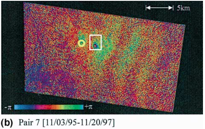 |
(b) Interferogram in Kuju volcanic region of Pair no. 7 [11/03/95? 11/20/97]. The framed area in both images is the location of Mt. Hossho. This area is same as the area in Fig. 2. The yellow circle shows the location of Hatchobaru area. From: Tomiyama et al. 2004. |
||
Reference List: Tomiyama et al. 2004; Sudo et al. 1998.
Full References:
Sudo, Y., Ono, H., Hurst, A.W., Tsutsui, T., Mori, T., Nakaboh, M., Matsumoto, Y., Sako, M., Yoshikawa, S., Tanaka, M. and Kobayashi, Y.,, 1998. Seismic activity and ground deformation associated with 1995 phreatic eruption of Kuju volcano, Kyushu, Japan. J. Volcanol. Geotherm. Res., 81: 245-267. https://doi.org/10.1016/S0377-0273(98)00011-0
Tomiyama, N., Koike, K., & Omura, M., 2004. Detection of topographic changes associated with volcanic activities of Mt. Hossho using D-InSAR. Advances in Space Research, 33(3), 279-283.
| Start Date: 1995 Sep 20 | Stop Date: 1995 Nov 03 | Direction: Uplift | Method: InSAR |
| Magnitude: 6.000 cm | Spatial Extent: Unknown | Latitude: Unknown | Longitude: Unknown |
Remarks: This deformation event brackets the eruption of Mt. Hossho on 11 October 1995. | |||
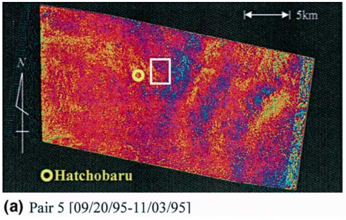 |
(a) Interferogram in Kuju volcanic region of Pair no. 5 [09/20/95?11/03/95]. The framed area in both images is the location of Mt. Hossho. This area is same as the area in Fig. 2. The yellow circle shows the location of Hatchobaru area. From: Tomiyama et al. 2004. |
||
Reference List: Tomiyama et al. 2004.
Full References:
Tomiyama, N., Koike, K., & Omura, M., 2004. Detection of topographic changes associated with volcanic activities of Mt. Hossho using D-InSAR. Advances in Space Research, 33(3), 279-283.
There is no Emissions History data available for Kujusan.
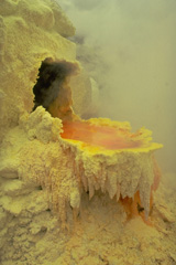 Liquid molten sulfur at a thermal area of the Kuju volcanic complex on the southern Japanese island of Kyushu drips over the lip of the small fumarolic vent. The sulfur then solidifies, forming these beautiful stalactite-like features on the side of the vent.
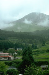 The Kuju Volcano Group consists of more than ten cones and lava domes NE of Aso caldera. Mimatayama, seen here at the NW side of the complex, has a summit lava dome. The first recorded eruptions were of phreatic or hydrothermall activity in the 17th and 18th centuries. Many hot springs and hydrothermal fields are located at the Kuju complex. A fumarole on Hosho lava dome was the site of a sulfur mine for at least 500 years.
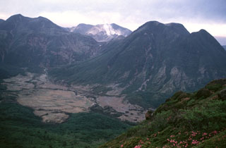 The Kuju volcano group in northern Kyushu consists of more than ten cones and lava domes NE of Aso caldera. This view from the E shows Mimatayama (right) and Nakadake (left) lava domes, which formed about 10,000-12,000 years ago. Gas-and-steam plumes rising from fumaroles are seen here in 1994 on the flank of Hosshozan (center), the site of small phreatic explosions in November 1995. Many hot springs and hydrothermal fields are located at the Kuju complex.
Maps are not currently available due to technical issues.
The maps shown below have been scanned from the GVP map archives and include the volcano on this page. Clicking on the small images will load the full 300 dpi map. Very small-scale maps (such as world maps) are not included.
There are no samples for Kujusan in the Smithsonian's NMNH Department of Mineral Sciences Rock and Ore collection.
| Copernicus Browser | The Copernicus Browser replaced the Sentinel Hub Playground browser in 2023, to provide access to Earth observation archives from the Copernicus Data Space Ecosystem, the main distribution platform for data from the EU Copernicus missions. |
| MIROVA | Middle InfraRed Observation of Volcanic Activity (MIROVA) is a near real time volcanic hot-spot detection system based on the analysis of MODIS (Moderate Resolution Imaging Spectroradiometer) data. In particular, MIROVA uses the Middle InfraRed Radiation (MIR), measured over target volcanoes, in order to detect, locate and measure the heat radiation sourced from volcanic activity. |
| MODVOLC Thermal Alerts | Using infrared satellite Moderate Resolution Imaging Spectroradiometer (MODIS) data, scientists at the Hawai'i Institute of Geophysics and Planetology, University of Hawai'i, developed an automated system called MODVOLC to map thermal hot-spots in near real time. For each MODIS image, the algorithm automatically scans each 1 km pixel within it to check for high-temperature hot-spots. When one is found the date, time, location, and intensity are recorded. MODIS looks at every square km of the Earth every 48 hours, once during the day and once during the night, and the presence of two MODIS sensors in space allows at least four hot-spot observations every two days. Each day updated global maps are compiled to display the locations of all hot spots detected in the previous 24 hours. There is a drop-down list with volcano names which allow users to 'zoom-in' and examine the distribution of hot-spots at a variety of spatial scales. |
|
WOVOdat
Single Volcano View Temporal Evolution of Unrest Side by Side Volcanoes |
WOVOdat is a database of volcanic unrest; instrumentally and visually recorded changes in seismicity, ground deformation, gas emission, and other parameters from their normal baselines. It is sponsored by the World Organization of Volcano Observatories (WOVO) and presently hosted at the Earth Observatory of Singapore.
GVMID Data on Volcano Monitoring Infrastructure The Global Volcano Monitoring Infrastructure Database GVMID, is aimed at documenting and improving capabilities of volcano monitoring from the ground and space. GVMID should provide a snapshot and baseline view of the techniques and instrumentation that are in place at various volcanoes, which can be use by volcano observatories as reference to setup new monitoring system or improving networks at a specific volcano. These data will allow identification of what monitoring gaps exist, which can be then targeted by remote sensing infrastructure and future instrument deployments. |
| Volcanic Hazard Maps | The IAVCEI Commission on Volcanic Hazards and Risk has a Volcanic Hazard Maps database designed to serve as a resource for hazard mappers (or other interested parties) to explore how common issues in hazard map development have been addressed at different volcanoes, in different countries, for different hazards, and for different intended audiences. In addition to the comprehensive, searchable Volcanic Hazard Maps Database, this website contains information about diversity of volcanic hazard maps, illustrated using examples from the database. This site is for educational purposes related to volcanic hazard maps. Hazard maps found on this website should not be used for emergency purposes. For the most recent, official hazard map for a particular volcano, please seek out the proper institutional authorities on the matter. |
| IRIS seismic stations/networks | Incorporated Research Institutions for Seismology (IRIS) Data Services map showing the location of seismic stations from all available networks (permanent or temporary) within a radius of 0.18° (about 20 km at mid-latitudes) from the given location of Kujusan. Users can customize a variety of filters and options in the left panel. Note that if there are no stations are known the map will default to show the entire world with a "No data matched request" error notice. |
| UNAVCO GPS/GNSS stations | Geodetic Data Services map from UNAVCO showing the location of GPS/GNSS stations from all available networks (permanent or temporary) within a radius of 20 km from the given location of Kujusan. Users can customize the data search based on station or network names, location, and time window. Requires Adobe Flash Player. |
| DECADE Data | The DECADE portal, still in the developmental stage, serves as an example of the proposed interoperability between The Smithsonian Institution's Global Volcanism Program, the Mapping Gas Emissions (MaGa) Database, and the EarthChem Geochemical Portal. The Deep Earth Carbon Degassing (DECADE) initiative seeks to use new and established technologies to determine accurate global fluxes of volcanic CO2 to the atmosphere, but installing CO2 monitoring networks on 20 of the world's 150 most actively degassing volcanoes. The group uses related laboratory-based studies (direct gas sampling and analysis, melt inclusions) to provide new data for direct degassing of deep earth carbon to the atmosphere. |
| Large Eruptions of Kujusan | Information about large Quaternary eruptions (VEI >= 4) is cataloged in the Large Magnitude Explosive Volcanic Eruptions (LaMEVE) database of the Volcano Global Risk Identification and Analysis Project (VOGRIPA). |
| EarthChem | EarthChem develops and maintains databases, software, and services that support the preservation, discovery, access and analysis of geochemical data, and facilitate their integration with the broad array of other available earth science parameters. EarthChem is operated by a joint team of disciplinary scientists, data scientists, data managers and information technology developers who are part of the NSF-funded data facility Integrated Earth Data Applications (IEDA). IEDA is a collaborative effort of EarthChem and the Marine Geoscience Data System (MGDS). |

