Vigorous fuming
When observed from an airplane on 13 May, the volcano continued to fume vigorously, but no active lava was seen.
Information Contacts: R. Moore, USGS; R. Koyanagi, M. Sako, and F. Trusdell, HVO.
The Global Volcanism Program has no Weekly Reports available for Farallon de Pájaros.
Reports are organized chronologically and indexed below by Month/Year (Publication Volume:Number), and include a one-line summary. Click on the index link or scroll down to read the reports.
Normal fuming and discolored water
"A 16 July USN flight also covered the Quaternary volcanoes of the Marianas. Fuming and discolored water were observed at Farallon de Pajaros but were not anomalous conditions."
Information Contacts: N. Banks, HVO.
Vigorous fuming
"Photographs taken by Civil Defense personnel in early August 1990 from a fixed-wing airplane showed vigorous fuming."
Information Contacts: R. Moore, USGS; R. Koyanagi and M. Sako, HVO.
Vigorous fuming
When observed from an airplane on 13 May, the volcano continued to fume vigorously, but no active lava was seen.
Information Contacts: R. Moore, USGS; R. Koyanagi, M. Sako, and F. Trusdell, HVO.
This compilation of synonyms and subsidiary features may not be comprehensive. Features are organized into four major categories: Cones, Craters, Domes, and Thermal Features. Synonyms of features appear indented below the primary name. In some cases additional feature type, elevation, or location details are provided.
Synonyms |
||||
| Uracas | Pajaros | Uraccas | Guy Rock | ||||
Craters |
||||
| Feature Name | Feature Type | Elevation | Latitude | Longitude |
| Makhahnas | Submarine crater | -640 m | 20° 28' 0" N | 144° 51' 0" E |
|
|
||||||||||||||||||||||||||
There is data available for 14 confirmed Holocene eruptive periods.
1952 Oct 26 ± 5 days - 1953 Apr 15 Confirmed Eruption VEI: 2
| Episode 1 | Eruption | Summit, east side | |||||||||||||||||||||||||||||||||||||||||||||||||
|---|---|---|---|---|---|---|---|---|---|---|---|---|---|---|---|---|---|---|---|---|---|---|---|---|---|---|---|---|---|---|---|---|---|---|---|---|---|---|---|---|---|---|---|---|---|---|---|---|---|---|
| 1952 Oct 26 ± 5 days - 1953 Apr 15 | Evidence from Observations: Reported | |||||||||||||||||||||||||||||||||||||||||||||||||
| Activity frequently seen in 1952, with explosions during October and November (Hantke, 1955). Lava flows were emplaced on the E and W sides of the summit during February-March 1953, with explosive activity until 15 April (Corwin, 1971). | ||||||||||||||||||||||||||||||||||||||||||||||||||
|
List of 8 Events for Episode 1 at Summit, east side
| ||||||||||||||||||||||||||||||||||||||||||||||||||
1951 Aug 16 ± 15 days Confirmed Eruption VEI: 2
| Episode 1 | Eruption | |||||||||||||||||||||||||
|---|---|---|---|---|---|---|---|---|---|---|---|---|---|---|---|---|---|---|---|---|---|---|---|---|---|
| 1951 Aug 16 ± 15 days - Unknown | Evidence from Observations: Reported | ||||||||||||||||||||||||
| Explosion and formation of subsidiary summit crater (Corwin, 1971). | |||||||||||||||||||||||||
|
List of 3 Events for Episode 1
| |||||||||||||||||||||||||
[ 1947 Jan (?) ] Uncertain Eruption
| Episode 1 | Uncertain | North side | ||||||||||||||||||||||||
|---|---|---|---|---|---|---|---|---|---|---|---|---|---|---|---|---|---|---|---|---|---|---|---|---|---|
| 1947 Jan (?) - Unknown | Evidence from Observations: Reported | ||||||||||||||||||||||||
| A plume of discolored sea water from the base of N-flank lava flows was seen in a photo from 1 February 1947; Corwin (1971) suggested that this was caused by cooling of lava flows that entered the sea within the previous few months. | |||||||||||||||||||||||||
|
List of 3 Events for Episode 1 at North side
| |||||||||||||||||||||||||
1943 Confirmed Eruption VEI: 2
| Episode 1 | Eruption | Summit, south side | ||||||||||||||||||||||||||||||||||
|---|---|---|---|---|---|---|---|---|---|---|---|---|---|---|---|---|---|---|---|---|---|---|---|---|---|---|---|---|---|---|---|---|---|---|---|
| 1943 - Unknown | Evidence from Observations: Reported | ||||||||||||||||||||||||||||||||||
| Explosive eruption, destruction of south crater wall, lava flows emplaced on south side (Corwin, 1971). | |||||||||||||||||||||||||||||||||||
|
List of 5 Events for Episode 1 at Summit, south side
| |||||||||||||||||||||||||||||||||||
1941 Mar 28 Confirmed Eruption VEI: 1
| Episode 1 | Eruption | |||||||||||||||||||||||||
|---|---|---|---|---|---|---|---|---|---|---|---|---|---|---|---|---|---|---|---|---|---|---|---|---|---|
| 1941 Mar 28 - Unknown | Evidence from Observations: Reported | ||||||||||||||||||||||||
| On the night of 28-29 March 1941 "fire was observed shooting out of the top and lava flowing down from the volcano" from a passing ship (Volcano Letter 472). | |||||||||||||||||||||||||
|
List of 3 Events for Episode 1
| |||||||||||||||||||||||||
1939 Confirmed Eruption VEI: 1
| Episode 1 | Eruption | East side ? | |||||||||||||||||||||||||||||
|---|---|---|---|---|---|---|---|---|---|---|---|---|---|---|---|---|---|---|---|---|---|---|---|---|---|---|---|---|---|---|
| 1939 - Unknown | Evidence from Observations: Reported | |||||||||||||||||||||||||||||
| Strombolian activity, east platform lava flow possibly emplaced at this time (Corwin, 1971). Tanakadate (1940) also noted that "This year [presumably 1939 as the manuscript was being prepared] it is manifesting again its characteristic eruptions." | ||||||||||||||||||||||||||||||
|
List of 4 Events for Episode 1 at East side ?
| ||||||||||||||||||||||||||||||
1936 Apr 15 ± 45 days Confirmed Eruption VEI: 1
| Episode 1 | Eruption | |||||||||||||||||||||||||
|---|---|---|---|---|---|---|---|---|---|---|---|---|---|---|---|---|---|---|---|---|---|---|---|---|---|
| 1936 Apr 15 ± 45 days - Unknown | Evidence from Observations: Reported | ||||||||||||||||||||||||
| Tanakadate (1940) reported that "In the spring of 1936, reports were received of the Strombolian activity of this volcano, but when the writer visited it in the summer of that year, the explosive eruptions were no more to be seen, slight sulphur fumes being all that could be seen issuing from the crater." | |||||||||||||||||||||||||
|
List of 3 Events for Episode 1
| |||||||||||||||||||||||||
[ 1934 ] Uncertain Eruption
| Episode 1 | Uncertain | |||||
|---|---|---|---|---|---|
| 1934 - Unknown | Evidence from Observations: Reported | ||||
| Without any linkage to eruptive activity described in September-October 1932 or early 1936, or the submarine event in summer 1934 (attributed to Ahyi in this catalog), Tanakadate (1940) notes that "For several months, in 1934, this volcano was quiescent." This suggests ongoing activity, possibly virtually continuous since 1932, but with no details to document a confirmed eruption. | |||||
1932 Sep 7 - 1932 Oct 7 Confirmed Eruption VEI: 2
| Episode 1 | Eruption | Summit, east side ? | ||||||||||||||||||||||||||||||||||
|---|---|---|---|---|---|---|---|---|---|---|---|---|---|---|---|---|---|---|---|---|---|---|---|---|---|---|---|---|---|---|---|---|---|---|---|
| 1932 Sep 7 - 1932 Oct 7 | Evidence from Observations: Reported | ||||||||||||||||||||||||||||||||||
| Strombolian activity, lava flow from summit to sea on W side; lava flow on the E side lava flow tentatively given a 1932 date (Corwin, 1971). Tanakadate (1940) reported that "According to Prof. Tayama, in September-October 1932, the volcano showed intermittently paroxysms every ten to twenty minutes. Following violent detonations, smoke columns rise up to heights of 150 m above the crater, hurling large blocks of red hot lava and lapilli into the sky, shortly after which liquid lava overflows the crater rim on the flank of the volcano into lava canals and find their way into the sea. At night, the incandescent lava could be seen streaming from the crater and dividing into three branches at the lower part, all of them reaching the sea." | |||||||||||||||||||||||||||||||||||
|
List of 5 Events for Episode 1 at Summit, east side ?
| |||||||||||||||||||||||||||||||||||
1928 Dec 15 ± 5 days Confirmed Eruption VEI: 2 (?)
| Episode 1 | Eruption | ||||||||||||||||||||
|---|---|---|---|---|---|---|---|---|---|---|---|---|---|---|---|---|---|---|---|---|
| 1928 Dec 15 ± 5 days - Unknown | Evidence from Observations: Reported | |||||||||||||||||||
| Report from fisherman of an eruption in mid-December 1928 with a high smoke column and violent air shocks (Tanakadate, 1931). | ||||||||||||||||||||
|
List of 2 Events for Episode 1
| ||||||||||||||||||||
1925 Confirmed Eruption VEI: 2
| Episode 1 | Eruption | |||||||||||||||||||||||||
|---|---|---|---|---|---|---|---|---|---|---|---|---|---|---|---|---|---|---|---|---|---|---|---|---|---|
| 1925 - Unknown | Evidence from Observations: Reported | ||||||||||||||||||||||||
| Tanakadate (1940) noted that in 1925 a "...strong Strombolian eruption was seen. In recent times, the activity has consisted of very violent paroxysmus, with emissions of scoriae, which explains the fire phenomena at night." | |||||||||||||||||||||||||
|
List of 3 Events for Episode 1
| |||||||||||||||||||||||||
1912 Confirmed Eruption VEI: 2
| Episode 1 | Eruption | North side ? | ||||||||||||||||||||||||||||||||||
|---|---|---|---|---|---|---|---|---|---|---|---|---|---|---|---|---|---|---|---|---|---|---|---|---|---|---|---|---|---|---|---|---|---|---|---|
| 1912 - Unknown | Evidence from Observations: Reported | ||||||||||||||||||||||||||||||||||
| Strombolian activity in 1912, lava flows on the north coast may have been emplaced at same time based on sketches and charts (Corwin, 1971). Tanakadate (1940) noted that in 1912 "...the activity was particularly violent...." | |||||||||||||||||||||||||||||||||||
|
List of 5 Events for Episode 1 at North side ?
| |||||||||||||||||||||||||||||||||||
1901 Jan (?) - 1902 Dec Confirmed Eruption VEI: 2
| Episode 1 | Eruption | Summit, east side | ||||||||||||||||||||||||||||||||||
|---|---|---|---|---|---|---|---|---|---|---|---|---|---|---|---|---|---|---|---|---|---|---|---|---|---|---|---|---|---|---|---|---|---|---|---|
| 1901 Jan (?) - 1902 Dec | Evidence from Uncertain | ||||||||||||||||||||||||||||||||||
| Lava flows on east side emplaced within and possibly prior to 1901 (Corwin, 1971); ash clouds were seen in May 1901 coming from the summit crater. Tanakadate (1940) stated that "In 1901 and 1902 it was... issuing smoke intermittently." | |||||||||||||||||||||||||||||||||||
|
List of 5 Events for Episode 1 at Summit, east side
| |||||||||||||||||||||||||||||||||||
1876 Jan 1 (?) - 1876 Jan 3 (?) Confirmed Eruption VEI: 2
| Episode 1 | Eruption | Summit, NE side | |||||||||||||||||||
|---|---|---|---|---|---|---|---|---|---|---|---|---|---|---|---|---|---|---|---|---|
| 1876 Jan 1 (?) - 1876 Jan 3 (?) | Evidence from Observations: Reported | |||||||||||||||||||
| Explosive eruptions of ash and tephra at 10-minute intervals was observed during a 1-3 January 1876 visit by the German warship SMS Hertha (Captain Knorr). | ||||||||||||||||||||
|
List of 2 Events for Episode 1 at Summit, NE side
| ||||||||||||||||||||
1872 Jul 11 Confirmed Eruption VEI: 2
| Episode 1 | Eruption | |||||||||||||||||||||||||
|---|---|---|---|---|---|---|---|---|---|---|---|---|---|---|---|---|---|---|---|---|---|---|---|---|---|
| 1872 Jul 11 - Unknown | Evidence from Observations: Reported | ||||||||||||||||||||||||
| Captain Almond of the British barque "Decapolis" reported the island in active eruption on 11 July 1872; a quantity of ashes was blown on board the ship while passing about 3 miles (~5 km) leeward of it (Office of the Marine Board of New South Wales, 1872). | |||||||||||||||||||||||||
|
List of 3 Events for Episode 1
| |||||||||||||||||||||||||
[ 1865 ] Discredited Eruption
The 1865 date from CAVW is actually the publication date of the 1864 eruption report.
1864 Jan 7 Confirmed Eruption VEI: 2
| Episode 1 | Eruption | SW side | |||||||||||||||||||
|---|---|---|---|---|---|---|---|---|---|---|---|---|---|---|---|---|---|---|---|---|
| 1864 Jan 7 - Unknown | Evidence from Observations: Reported | |||||||||||||||||||
| "Thick black smoke" was issuing from the SW side when seen during the voyage of the Spanish corvette Narvaez, under the command of D. Eugenio Sanchez y Zayas (Rosser, 1870). The 1865 date from CAVW is actually the publication date (Sanchez, 1865, "Anuario de la Direccion de Hidrografia,” año iii.) where the 1864 visit was reported. | ||||||||||||||||||||
|
List of 2 Events for Episode 1 at SW side
| ||||||||||||||||||||
There is no Deformation History data available for Farallon de Pájaros.
There is no Emissions History data available for Farallon de Pájaros.
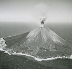 Explosive activity was frequently observed from Farallon de Pajoras volcano in October and November 1952. Lava flows were emplaced on the E and W sides of the summit in February-March 1953. This 1953 photo from the E shows a small plume rising above the summit crater and lighter-gray lava flows in the center that erupted in 1953. The lobe just left of center eventually reached the coast. Explosive activity continued until 15 April. The steep-sided peak on the SE coastline is a remnant of an older caldera.
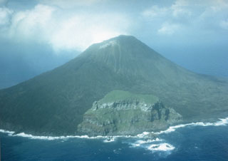 The 2-km-wide island of Farallon de Pajaros is the northernmost and most active volcano of the Mariana Islands. It has been referred to as the "Lighthouse of the western Pacific." The symmetrical, sparsely vegetated cone formed within a caldera, remnants of which form the peak seen here in 1980 in the center along the SE coast. Both summit and flank vents have been active during historical time; flank fissures formed lava flows along the coast.
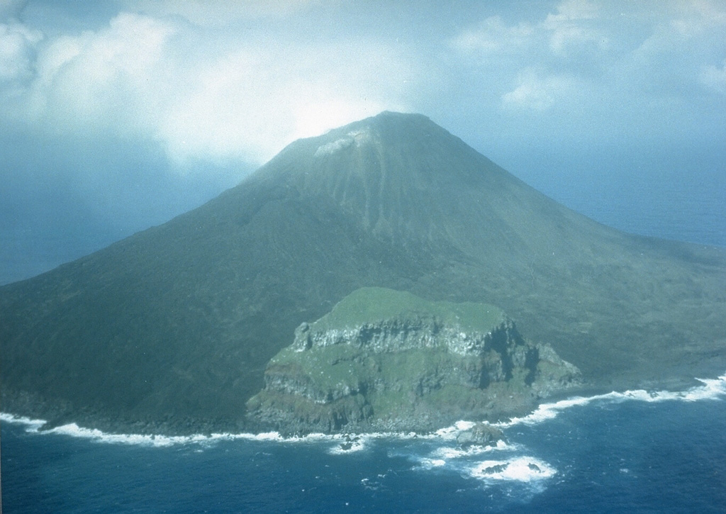
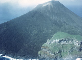 This 1980 photo from the SE of the small island volcano of Farallón de Pájaros shows unvegetated lava flows that diverted around the vegetated peak to the lower right, which is a remant of a caldera that formed prior to the formation of the present cone.
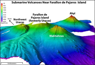 Ahyi seamount (upper right) is a large submarine volcano that rises to within about 150 m of the sea surface about 18 km SE of the island of Farallon de Pajaros (left-center). At various times since 1979, water discoloration, felt seismicity followed by upwelling of sulfur-bearing water, and a seismically detected submarine eruption have been reported at or near the seamount. Two submarine volcanoes on the flanks of Farallon de Pajaros, Northwest Uracas and Makhahnas, are seen in this NOAA bathymetric image.
The Global Volcanism Program has no maps available for Farallon de Pájaros.
There are no samples for Farallon de Pájaros in the Smithsonian's NMNH Department of Mineral Sciences Rock and Ore collection.
| Copernicus Browser | The Copernicus Browser replaced the Sentinel Hub Playground browser in 2023, to provide access to Earth observation archives from the Copernicus Data Space Ecosystem, the main distribution platform for data from the EU Copernicus missions. |
| MIROVA | Middle InfraRed Observation of Volcanic Activity (MIROVA) is a near real time volcanic hot-spot detection system based on the analysis of MODIS (Moderate Resolution Imaging Spectroradiometer) data. In particular, MIROVA uses the Middle InfraRed Radiation (MIR), measured over target volcanoes, in order to detect, locate and measure the heat radiation sourced from volcanic activity. |
| MODVOLC Thermal Alerts | Using infrared satellite Moderate Resolution Imaging Spectroradiometer (MODIS) data, scientists at the Hawai'i Institute of Geophysics and Planetology, University of Hawai'i, developed an automated system called MODVOLC to map thermal hot-spots in near real time. For each MODIS image, the algorithm automatically scans each 1 km pixel within it to check for high-temperature hot-spots. When one is found the date, time, location, and intensity are recorded. MODIS looks at every square km of the Earth every 48 hours, once during the day and once during the night, and the presence of two MODIS sensors in space allows at least four hot-spot observations every two days. Each day updated global maps are compiled to display the locations of all hot spots detected in the previous 24 hours. There is a drop-down list with volcano names which allow users to 'zoom-in' and examine the distribution of hot-spots at a variety of spatial scales. |
|
WOVOdat
Single Volcano View Temporal Evolution of Unrest Side by Side Volcanoes |
WOVOdat is a database of volcanic unrest; instrumentally and visually recorded changes in seismicity, ground deformation, gas emission, and other parameters from their normal baselines. It is sponsored by the World Organization of Volcano Observatories (WOVO) and presently hosted at the Earth Observatory of Singapore.
GVMID Data on Volcano Monitoring Infrastructure The Global Volcano Monitoring Infrastructure Database GVMID, is aimed at documenting and improving capabilities of volcano monitoring from the ground and space. GVMID should provide a snapshot and baseline view of the techniques and instrumentation that are in place at various volcanoes, which can be use by volcano observatories as reference to setup new monitoring system or improving networks at a specific volcano. These data will allow identification of what monitoring gaps exist, which can be then targeted by remote sensing infrastructure and future instrument deployments. |
| Volcanic Hazard Maps | The IAVCEI Commission on Volcanic Hazards and Risk has a Volcanic Hazard Maps database designed to serve as a resource for hazard mappers (or other interested parties) to explore how common issues in hazard map development have been addressed at different volcanoes, in different countries, for different hazards, and for different intended audiences. In addition to the comprehensive, searchable Volcanic Hazard Maps Database, this website contains information about diversity of volcanic hazard maps, illustrated using examples from the database. This site is for educational purposes related to volcanic hazard maps. Hazard maps found on this website should not be used for emergency purposes. For the most recent, official hazard map for a particular volcano, please seek out the proper institutional authorities on the matter. |
| IRIS seismic stations/networks | Incorporated Research Institutions for Seismology (IRIS) Data Services map showing the location of seismic stations from all available networks (permanent or temporary) within a radius of 0.18° (about 20 km at mid-latitudes) from the given location of Farallon de Pájaros. Users can customize a variety of filters and options in the left panel. Note that if there are no stations are known the map will default to show the entire world with a "No data matched request" error notice. |
| UNAVCO GPS/GNSS stations | Geodetic Data Services map from UNAVCO showing the location of GPS/GNSS stations from all available networks (permanent or temporary) within a radius of 20 km from the given location of Farallon de Pájaros. Users can customize the data search based on station or network names, location, and time window. Requires Adobe Flash Player. |
| DECADE Data | The DECADE portal, still in the developmental stage, serves as an example of the proposed interoperability between The Smithsonian Institution's Global Volcanism Program, the Mapping Gas Emissions (MaGa) Database, and the EarthChem Geochemical Portal. The Deep Earth Carbon Degassing (DECADE) initiative seeks to use new and established technologies to determine accurate global fluxes of volcanic CO2 to the atmosphere, but installing CO2 monitoring networks on 20 of the world's 150 most actively degassing volcanoes. The group uses related laboratory-based studies (direct gas sampling and analysis, melt inclusions) to provide new data for direct degassing of deep earth carbon to the atmosphere. |
| Large Eruptions of Farallon de Pájaros | Information about large Quaternary eruptions (VEI >= 4) is cataloged in the Large Magnitude Explosive Volcanic Eruptions (LaMEVE) database of the Volcano Global Risk Identification and Analysis Project (VOGRIPA). |
| EarthChem | EarthChem develops and maintains databases, software, and services that support the preservation, discovery, access and analysis of geochemical data, and facilitate their integration with the broad array of other available earth science parameters. EarthChem is operated by a joint team of disciplinary scientists, data scientists, data managers and information technology developers who are part of the NSF-funded data facility Integrated Earth Data Applications (IEDA). IEDA is a collaborative effort of EarthChem and the Marine Geoscience Data System (MGDS). |

