
According to a news report, on 8 February volcanic tremor occurred at Tokachi that lasted for 37 minutes. A Japan Meteorological Agency monitor did not see any emissions or other signs that an eruption had occurred.
Source: Associated Press
Small hot gas emissions and minor seismicity in mid-2012
During 1995-1996, Tokachi (also called Tokachi-dake) intermittently experienced increased seismicity (BGVN 20:07, 20:08, 20:11/12, and 21:05). The volcano is located in central Hokkaido, the northernmost of Japan's 47 prefectures (figure 6).
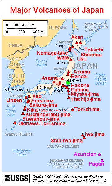 |
Figure 6. A map showing the major volcanoes of Japan; Tokachi is in the upper right. Courtesy of the U.S. Geological Survey. |
Monthly reports of volcanic activity from the Japan Meteorological Agency (JMA) translated into English resumed in October 2010. The only recent English-translated JMA report on Tokachi appeared in June 2012. The only other account available on this volcano between 1996 and June 2012 was in 2003, when a news account (Associated Press) mentioned that volcanic tremor occurred on 8 February 2003 and lasted for 37 minutes. This news account noted that the JMA saw no emissions or other signs that an eruption had occurred.
According to JMA, a small event in Taisho crater occurred, apparently on 1 June 2012. Hot gas from this event flowed down the NE and E flanks of Tokachi. Aerial observations on 1 June 2012 with an infrared camera revealed high temperature areas on the E wall of Taisho crater. No ejecta such as volcanic ash was observed around the crater. A field study that same day measured the average sulfur dioxide flux as 600 metric tons/day (t/d). After 4 June, the crater's temperature and gas emission volume decreased.
According to JMA, on 30 June 2012 volcanic glow in the Taisho crater was observed with a high-sensitivity camera. This glow gradually brightened toward the early morning of 1 July and continued through the early morning of 5 July. Thereafter, the glow diminished, suggesting a decreasing temperature. JMA believed the glow stemmed from the emission of high-temperature volcanic gases and the burning of sulfur. No changes occurred with respect to volcanic earthquakes, tremor, ground deformation, and infrasonic data either before or after the period of volcanic glow.
On 1 July, infrared camera observations again revealed high-temperature areas on the E wall of Taisho crater. These high temperatures persisted through most of July, after which they returned to normal. Several reports in July noted a small new fumarole near an existing fumarole on the E wall of the crater. Scientists conducting a field survey on 1 July measured the flux of sulfur dioxide from the fumarole at 600 t/d. No field surveys were conducted after 3 July because of bad weather, but officials believed that SO2 levels had decreased, given that emissions from the fumarole had decreased.
On 11 July, instruments recorded small-amplitude, short-duration volcanic tremor. This was followed by small-amplitude volcanic earthquakes until the next morning. These events were not accompanied by any change in fumarole emissions, infrasonic data, or ground-deformation data. The hypocenters were located just beneath the shallow part of the Ground Crater (in Japanese, Guraundo-kako; translates into English as "old crater").
In July, GPS ground deformation data at Mae-Tokachi-Dake, a stratovolcano cone of Tokachi, found a small area of inflation at the shallow part of a crater designated as 62-2.
Information Contacts: Japan Meteorological Agency (JMA), Otemachi, 1-3-4, Chiyoda-ku Tokyo 100-8122, Japan (URL: http://www.jma.go.jp/); Associated Press (URL: https://www.ap.org/).
2003: February
According to a news report, on 8 February volcanic tremor occurred at Tokachi that lasted for 37 minutes. A Japan Meteorological Agency monitor did not see any emissions or other signs that an eruption had occurred.
Source: Associated Press
Reports are organized chronologically and indexed below by Month/Year (Publication Volume:Number), and include a one-line summary. Click on the index link or scroll down to read the reports.
Hot water ejected; new 10-15 m fissure forms
On the morning of 29 May, personnel of JMA's Tokachidake Volcano Observatory saw hot muddy water being ejected from a fumarole on the 1962 crater wall. The next day, they found that a 10-15-m fissure [or an elongated crater] had formed [on the wall of the 1962 crater]. Muddy water was continuously ejected from the fissure during their observations.
This activity stopped on 5 June. Thermal activity at the crater has been gradually increasing since 1983, although local seismic activity has remained at background levels.
Information Contacts: JMA, Tokyo.
Two new vents eject hot water, burning sulfur
Thermal activity that formed new vents [on the wall of] the 1962 crater began in late May and continued through July. Beginning on 29 May and ending 5 June, hot muddy water was ejected from a new 10-m-diameter oval vent in the wall of a summit crater formed in 1962. Weak ash emission occurred nearby on 19 June, forming a second new vent, also oval and about 15 m in diameter, on 20 June. Molten sulfur burned in and around the new vents and weak red glow was observed over the 1962 crater from the town of Biei, 7 km away, on the nights of 20-22 June.
The second hot muddy water ejection began on 24 June. JMA personnel from the Tokachidake Observatory visited the crater on 9 July and found that this activity had stopped. On 25 July, a third ejection began at the June vent and continued through 31 July. The maximum height of white plumes from the two new craters was 80 m [in July]. Seismicity remained low in June and early July, as in previous months. Thermal activity at the 1962 crater has been gradually increasing since 1983.
Information Contacts: JMA, Tokyo.
Third phase of hot muddy water ejection
The third phase of hot muddy ejection began on 25 July. Muddy water was carried 10 m above the [new crater that had formed on the E wall of the 1962 crater] when ejection began, but gradually declined. As of 1 November, water ejection had not been observed from the Volcano Observatory since 6 August. Figure 1 shows recently formed features at the E wall of the 1962 crater.
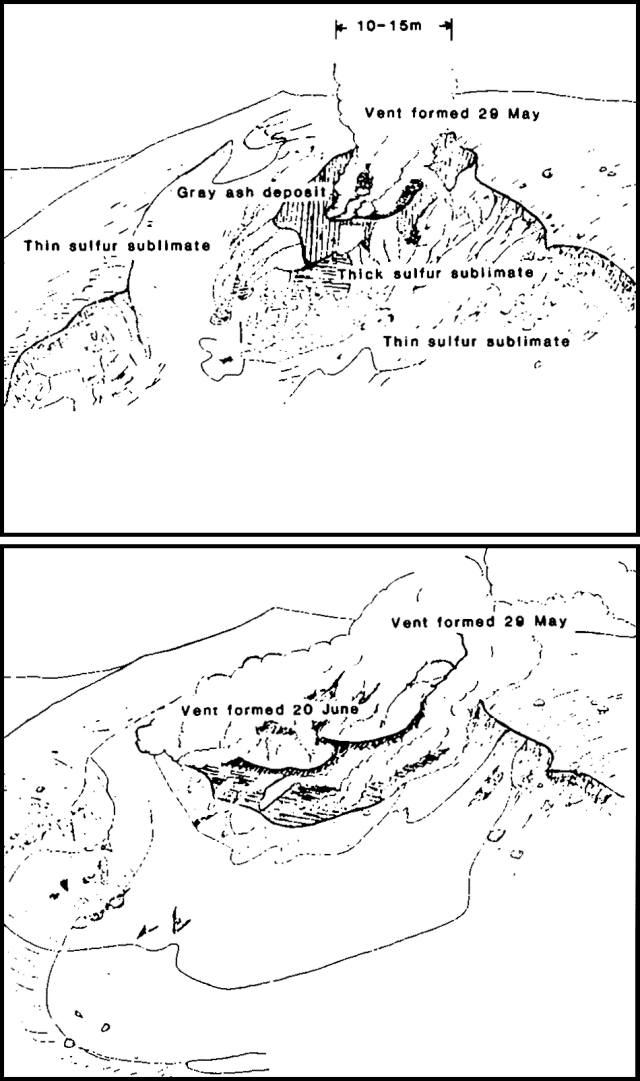 |
Figure 1. Sketch map of the E wall of the 1962 crater of Tokachidake on 7 June (top), and 25 June (bottom). Courtesy of JMA. |
Further Reference. Miyakawa, H., Maekawa, T., and Yokoyama, I., 1986, Monitoring of the temperature by infrared thermometry at the crater wall of Tokachi volcano, Hokkaido: Geophysical Bulletin, Hokkaido University, v. 47, p. 17-31.
Information Contacts: JMA, Tokyo.
Ground temperature increase; tremor and seismic swarms
Thermal activity remained at a relatively high level around the June 1985 crater, which formed on the E wall of the 1962 summit crater during an eruption of hot muddy water [from two fissure vents]. Underground temperatures around the crater have increased since 1984, to 529°C during a field survey on 7 October 1986. Continuous tremor was recorded on 20 December 1986 from 0020 to 0046 at a seismograph station 4.5 km NNW of the 1962 craters. Volcanic tremor had last been recorded on 1 September 1985. Tremor resumed at 0716 on 11 February and lasted for 32 minutes. Smaller amplitude tremor (~10% of former events) occurred on 21 February and twice on 1 March, lasting 12, 13, and 43 minutes respectively. Swarms of volcanic microearthquakes were recorded on 25 November and 6 December 1986. 82 events were registered on 25 November and 32 events on 6 December by the seismograph 2 km NW of the 1962 crater.
Information Contacts: JMA.
Earthquakes and large steam plume
Local seismicity was at a high level in November. A seismometer, 4.5 km NW of the three craters active in 1962, recorded 29 events on 15 November, 9 on the 19th, and 10 on the 26th. The month's total increased to 93 from [43] in October. Four shocks were felt, three on 15 November and one on the 27th. Epicenters were estimated to be around crater 62-2. On 22 November, personnel at the JMA Tokachidake Observatory saw a 1,200-m steam plume emerge from crater 62-2, the highest since a 1,400-m plume in June 1981.
Addendum. The press reported that Tokachi began to erupt on 19 December at 2148 [but see 13:12], ejecting incandescent tephra and a plume that rose about 2 km. Ash fell on two cities more than 100 km NE of the volcano. A lahar about 30 m wide flowed 2.5 km downslope. Children within 25 km of the volcano were kept home from school the next day and residents were warned by officials to be ready to evacuate. The eruption had apparently declined, but seismicity was continuing.
Information Contacts: JMA; AP; UPI.
Ash ejection; small pyroclastic flows and mudflow
Tokachi-dake's first large eruption since 1962 followed more than two months of gradually increasing seismicity. The number of recorded earthquakes began to build in late September, totaling 43 in October and 93 in November compared to the typical background level of 10-20 events/month (figure 2). Stronger seismicity from 19 November was followed by emission of a 1,200-m white plume on the 22nd from crater 62-2, one of a line of vents formed during the 1962 eruption. Occasional episodes of volcanic tremor, the first in more than a year, had been recorded since 4 October and became more frequent in early December. Eruptive activity followed through most of December.
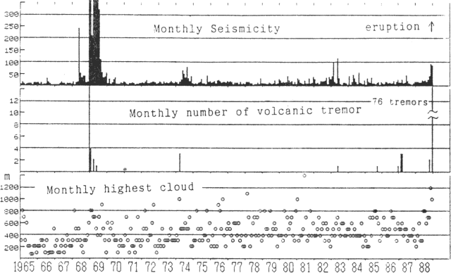 |
Figure 2. Monthly recorded earthquakes (top), number of volcanic tremor episodes (middle), and height of highest observed cloud (bottom) at Tokachi, 1965-88. Courtesy of JMA. |
Snow darkened by ash was first noticed on 5 December. A gray plume rose 200 m on 10 December and ash again fell near the crater. No gray plumes had been seen since 1962 from JMA's Tokachi-dake Observatory, [5.8] km NW of the crater, although bad weather has often prevented observation, especially in winter when the crater is only visible about once a week. Tremor episodes were more frequent after 11 December. Light gray to gray plumes were again observed 11-12 December. Darkened snow was seen from the air the morning of the 13th, extending ~1 km N from crater 62-2, and Observatory personnel saw a gray to dark gray plume emerging from the crater from about 1430 to 1600 that day.
A vigorous phreatic eruption from crater 62-2 began at roughly 0600 on 16 December. The eruption was preceded by an earthquake at 0524 that was felt at intensity III (JMA scale) in Fukiage, 3 km W of the crater. Volcanic tremor was recorded between 0603 and 0611 but weather clouds obscured the crater and the start time of the eruption remains uncertain. Ash began to fall at Ikeda, 80 km SE of the volcano, at around 0700. A similar sequence began on 18 December at 0838 with an earthquake felt in Fukiage at intensity I, followed by 21 minutes of volcanic tremor. Clouds again obscured the volcano, but ashfall began around 0900 at towns as much as 30 km E of the volcano.
An earthquake on 19 December at 2148 (intensity I in Fukiage) marked the onset of phreatomagmatic activity from crater 62-2 that was accompanied by a long period of high-amplitude volcanic tremor. People near the volcano saw an incandescent column and a dark volcanic cloud. A small mudflow, generated by snowmelt, moved ~600 m down the NW flank, reaching 1,400 m elevation. Yoshio Katsui noted that a pyroclastic surge had melted snow in an area of 500 x 800 m. Although the highest ash cloud seen from the Observatory reached only 300 m, ash reached Abashiri and Kitami on the NE coast of Hokkaido, 150 km from the volcano. Weak volcanic tremor continued intermittently the next day and a light gray to gray plume was rising 200-400 m during the morning. Slight ashfalls were reported to 35 km from the volcano on the 21st and to 15 km 22-23 December. Periods of volcanic tremor continued.
A larger phreatomagmatic eruptive episode began at 2212 on 24 December, accompanied by an earthquake. An incandescent column rose 200 m and the 1-km ash cloud contained lightning. A pyroclastic flow advanced 1 km NW but there was no mud flow and no property was damaged. At 2232, the mayor of Kami-Furano instructed residents of 3 inhabited areas within 15 km W of the crater to evacuate; 2 minutes later, the evacuation of the Shirogane area, 6 km NW, was requested by the mayor of Biei. Population of the four affected areas is about 800. Vigorous eruption resumed at 0049, feeding similar columns of ash and incandescent tephra. JMA Observatory personnel saw a glowing flow descend to the NW. Volcanic tremor was recorded 0049-0315 and 0332-0340. Tremor and emission of a gray plume continued intermittently during the day. Ashfalls extended 80 km SE. A morning overflight revealed a somewhat enlarged 62-2 crater, but other craters and fumarolic areas appeared unchanged. Fieldwork by Katsui and others documented a pyroclastic flow 1 km long with a maximum temperature of 92°C at 50 cm depth, 60 hours after the eruption.
An earthquake at 0527 on 30 December, felt at intensity 1 at Fukiage, marked renewed eruptive activity. Weather clouds prevented observations but ash fell 30 km SE. Evacuation of the Kami-Furano area was cancelled 31 December, but was continued for Shirogane residents. Red glow and ejection of a black cloud were observed from the JMA Observatory on 1 January at 0212. The eruption seemed small and only nearby ashfalls were reported.
Activity resumed briefly on 8 January at 1938. An incandescent column was seen for a short time but weather obscured the volcano from JMA Observatory staff. Ash fell on towns to a few tens of kilometers SW of the volcano but no damage was reported. An earthquake was recorded at the beginning of the 8 January activity, probably an explosion shock of the type common in earlier explosive episodes. Volcanic tremor followed for about 10 minutes, and geologists presumed that the eruption ended as tremor ceased.
Of the three types of JMA official volcano information releases, the most serious (Volcanic Activity Information) is issued when volcanism is considered to be dangerous to people. VAI releases appeared three times during the eruption, all during the 24-25 December activity, while Extra Volcano Information reports were produced 23 times in November and December for activity judged less hazardous.
Information Contacts: JMA.
Continued explosions (and partial evacuation)
By 8 February, 20 eruptive episodes had occurred from crater 62-2 (figure 3). During January, crater 62-2 emitted steam with occasional small amounts of gray ash. Red glow from the crater was seen almost every night from JMA's Tokachi-dake Volcano Observatory. White plumes continuously rose a few tens of meters from craters 62-0 and 62-1. Red glow in Taisho Crater was often seen 8-14 January. Residents of the Shirogane area (6 km NW) have remained evacuated since the 24-25 December eruption.
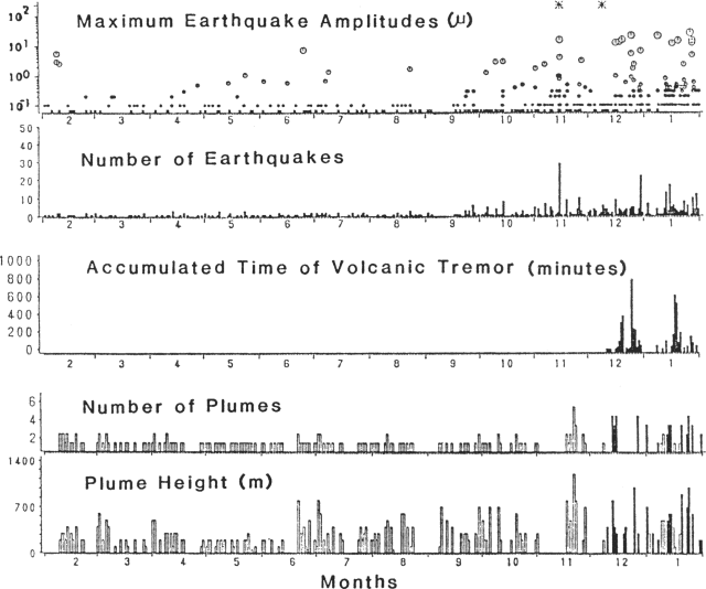 |
Figure 3. Summary of volcanic and seismic activity at Tokachi-dake, February 1988-January 1989. Courtesy of JMA. |
Seismicity was at a high level during the second half of January. A seismometer (4.5 km NNW of the volcano) registered 126 volcanic earthquakes during the month, an increase from 104 in December. Volcanic tremor episodes with amplitudes of about 0.1 µm were intermittently recorded by the same seismometer. An earthquake swarm, centered ~25 km E of the volcano, began on 14 January. Some of the events were felt at the observatory. The strongest had an intensity of III on 14 January.
The following is a summary of eruptive activity during the report period:
16 January at 1855: the eruption was accompanied by an earthquake felt at Intensity I at the Observatory. Ash fell as far E as Nukabira, 45 km away. Cloudy weather prevented plume observation. A field survey on 18 January revealed that a pyroclastic flow had advanced 1 km down the NW flank, along the same route as the mudflow caused by the 24-25 December eruption.
20 January, 0322: The eruption was accompanied by a weak explosion sound and incandescent column. Low-frequency volcanic tremor began 2 minutes before the eruption on the Hokkaido Univ seismometer at Hinangoya, 1 km ENE of the 1962 craters. Ash fell 30 km E of the volcano. A 900-m-high, grayish-white plume was seen from the Observatory at 0700.
[An explosion on 22 January is listed in 14:2].
24 January, 1224: The highest plume of the month reached 1,000 m above the crater.
28 January, 0518, 0611, and 0700: three explosions were accompanied by air shocks. Explosion sounds were heard at Shirogane hot spring, 6 km from the crater. Cloudy weather prevented plume observation. Slight ashfall was observed as far as 80 km SE of the volcano.
1 February, 1818: Low-frequency earthquakes were recorded at Hinangoya at 1700, preceding the eruption. Ash fell 70 km E.
4 February, 0038: Ash fell 100 km from the volcano.
[See 14:2 for explosions 6-7 February].
8 February, 0402: An eruption was accompanied by an explosion sound and incandescent column. A small pyroclastic flow descended from the crater.
Information Contacts: JMA.
One new explosion; seismicity declines
During the first eight days in February, five explosions from crater 62-2 were recorded. On 5 March at 0522, a brief eruption occurred after 25 days of quiet. No ground shocks were felt, but small earthquakes were recorded at 0522, 0524, and 0526. Volcanic tremor was intermittently recorded 0523-0725 by a seismograph 4.5 km NNW of the 1962 craters. Cloudy weather obscured the active crater, but when visibility returned, a blackish-gray plume was observed at 0810. A 1-km-long, narrow mudflow, produced by the eruption, descended NW along the same path as December-February mudflows and pyroclastic flows. A small amount of ashfall was reported ~25 km SE of the 1962 craters.
A total of 21 eruptions have been recorded or observed (table 1) since 16 December 1988. The seismograph 4.5 km NNW of crater 62-2 recorded 49 earthquakes in February (see figure 4). Seismicity declined to low levels after mid-February. A grayish-white plume steadily rose 300-500 m above crater 62-2.
Table 1. Eruptions at Tokachi from 16 December 1988 through 5 March 1989. Courtesy of JMA.
| Date | Time | Ashfall area | Comments |
| 16 Dec 1988 | early | 80 km SE | -- |
| 18 Dec 1988 | 0840 | 60 km | -- |
| 19 Dec 1988 | 2148 | more than 150 km | Largest ashfall, mudflow. |
| 24 Dec 1988 | 2212 | 80 km | Mudflow, evacuation. |
| 25 Dec 1988 | 0049 | 80 km | Pyroclastic flow. |
| 30 Dec 1988 | 0527 | 40 km SE | -- |
| 01 Jan 1989 | 0212 | -- | -- |
| 08 Jan 1989 | 1938 | 40 km SE | -- |
| 16 Jan 1989 | 1855 | 40 km SE | Pyroclastic flow. |
| 20 Jan 1989 | 0322 | 20 km E | -- |
| 22 Jan 1989 | 0014 | -- | -- |
| 27 Jan 1989 | 0144 | -- | -- |
| 28 Jan 1989 | 0518 | 80 km E | -- |
| 28 Jan 1989 | 0611 | 80 km E | -- |
| 28 Jan 1989 | 0700 | 80 km E | -- |
| 01 Feb 1989 | 1818 | 80 km E | -- |
| 04 Feb 1989 | 0038 | 110 km SE | -- |
| 06 Feb 1989 | 0937 | 40 km E | -- |
| 07 Feb 1989 | 2354 | -- | -- |
| 08 Feb 1989 | 0402 | 140 km E | Pyroclastic flow. |
| 05 Mar 1989 | 0522 | 25 km SE | Mudflow. |
Further Reference. Special Section: The 1988-1989 eruption of Mt. Tokachi, central Hokkaido: Bulletin of the Volcanological Society of Japan, v. 35, no. 2 (July 1990), p. 111-215 (6 papers, in English).
Information Contacts: JMA.
Continuous steam emission; decreased seismicity
Activity continued to decrease in March. Since the brief 5 March explosion (14:02) no explosions have been observed and seismicity has been low (figure 4). The steam plume reached a maximum height of 1,000 m above the rim of 62-2 Crater at 1300 on the 28th. An earthquake swarm that began 14 January . . . declined during March.
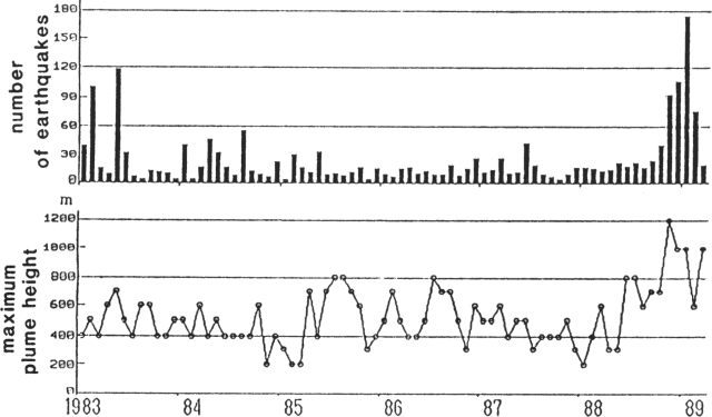 |
Figure 4. Monthly number of earthquakes at Tokachi-dake (top) and maximum monthly plume heights (bottom), January 1983-March 1989. Courtesy of JMA. |
Information Contacts: JMA.
Seismicity increases; no explosions
Tephra produced by the phreatomagmatic explosions that began 19 December contained a little fresh magma (scoria and blocks) of basaltic andesite composition similar to that of the 1926 and 1962 ejecta. Some of the pyroclastic flows and surges melted snow and fed small lahars. A detailed description of this eruption can be found in Katsui (1989).
No eruptive activity has occurred since a brief explosion from crater 62-2 on 5 March. A continuous steam plume, which often contained ash in May but was white in June, was observed from Tokachi-dake Observatory. Plume heights reached 800 m above the crater rim in May and 100-600 m in June. A seismograph 4.5 km NNW of the crater recorded only five volcanic earthquakes and no volcanic tremor in May, but seismicity increased in late June (figure 5). A total of 25 volcanic earthquakes was recorded in June, and seismicity remained elevated as of early July.
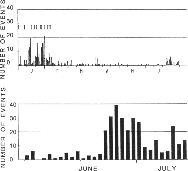 |
Figure 5. Daily number of local seismic events, 1 January-9 July 1989 (top) and number of small earthquakes recorded by a seismograph ~2 km NW of the volcano, 11 June-9 July 1989 (bottom). Courtesy of JMA. |
Reference. Katsui, Y., ed., 1989, The 1988 eruption of Tokachi-dake, its sequence, mechanism, and influence on community: Report of Natural Disaster Scientific Research no. B-63-5, March 1989, 108 pp (8 papers).
Information Contacts: JMA.
Tremor episode
Weak volcanic tremor was recorded 19 June.... The tremor episode was the fifth and strongest recorded since April 1989 (table 2).... The number of earthquakes has remained fairly constant since August 1989.
Table 2. Amplitude of volcanic tremor episodes at Tokachi, May 1989-June 1990.
| Date | Amplitude |
| 24 Jul 1989 | 0.01µ |
| 24 Dec 1989 | 0.04µ |
| 18 Jan 1990 | 0.01µ |
| 22 Feb 1990 | 0.02µ |
| 19 Jun 1990 | 0.05µ |
Information Contacts: JMA.
For the first time since 1989, monthly seismic events total over 100
Increased seismicity starting on 9 July was recorded 4.3 km NNW of the 1962 crater. The peak daily high for the month took place on 17 July (28 events). During the entire month of July there were 101 events. Not since January 1989, when 179 seismic events were recorded, have >100 events occurred in one month.
Information Contacts: Volcanological Division, Seismological and Volcanological Department, Japan Meteorological Agency (JMA), 1-3-4 Ote-machi, Chiyoda-ku, Tokyo 100, Japan.
Tremor event and increased seismicity
A volcanic tremor event and 20 seismic events were observed on 18 August at Station A, 4.5 km NNW of Crater 62-2. On 23 August another 19 events were recorded. In total, 77 earthquakes were detected in August. This period of increased seismicity began on 9 July.
Information Contacts: Volcanological Division, Seismological and Volcanological Department, Japan Meteorological Agency (JMA), 1-3-4 Ote-machi, Chiyoda-ku, Tokyo 100 Japan.
Gradual increase in the number of seismic events
During the second half of December, the number of earthquakes gradually increased, totalling 103 for the month. Consisting of a NE-SW aligned group of stratovolcanoes, Tokachi has a record that includes a partial cone collapse in 1925 that led to ~144 deaths and 5,000 homes destroyed.
Information Contacts: Volcanological Division, Seismological and Volcanological Department, Japan Meteorological Agency (JMA), 1-3-4 Ote-machi, Chiyoda-ku, Tokyo 100 Japan.
Seismic activity increases
High seismicity during 18-22 May included 50 events on the 19th. Neither volcanic tremor nor any geophysical changes were observed. A seismicity increase also occurred in December 1995 (BGVN 20:11/12).
Information Contacts: Japan Meteorological Agency (JMA), Volcanological Division, Seismological and Volcanological Department, 1-3-4 Ote-machi, Chiyoda-ku, Tokyo 100, Japan.
Small hot gas emissions and minor seismicity in mid-2012
During 1995-1996, Tokachi (also called Tokachi-dake) intermittently experienced increased seismicity (BGVN 20:07, 20:08, 20:11/12, and 21:05). The volcano is located in central Hokkaido, the northernmost of Japan's 47 prefectures (figure 6).
|
Figure 6. A map showing the major volcanoes of Japan; Tokachi is in the upper right. Courtesy of the U.S. Geological Survey. |
Monthly reports of volcanic activity from the Japan Meteorological Agency (JMA) translated into English resumed in October 2010. The only recent English-translated JMA report on Tokachi appeared in June 2012. The only other account available on this volcano between 1996 and June 2012 was in 2003, when a news account (Associated Press) mentioned that volcanic tremor occurred on 8 February 2003 and lasted for 37 minutes. This news account noted that the JMA saw no emissions or other signs that an eruption had occurred.
According to JMA, a small event in Taisho crater occurred, apparently on 1 June 2012. Hot gas from this event flowed down the NE and E flanks of Tokachi. Aerial observations on 1 June 2012 with an infrared camera revealed high temperature areas on the E wall of Taisho crater. No ejecta such as volcanic ash was observed around the crater. A field study that same day measured the average sulfur dioxide flux as 600 metric tons/day (t/d). After 4 June, the crater's temperature and gas emission volume decreased.
According to JMA, on 30 June 2012 volcanic glow in the Taisho crater was observed with a high-sensitivity camera. This glow gradually brightened toward the early morning of 1 July and continued through the early morning of 5 July. Thereafter, the glow diminished, suggesting a decreasing temperature. JMA believed the glow stemmed from the emission of high-temperature volcanic gases and the burning of sulfur. No changes occurred with respect to volcanic earthquakes, tremor, ground deformation, and infrasonic data either before or after the period of volcanic glow.
On 1 July, infrared camera observations again revealed high-temperature areas on the E wall of Taisho crater. These high temperatures persisted through most of July, after which they returned to normal. Several reports in July noted a small new fumarole near an existing fumarole on the E wall of the crater. Scientists conducting a field survey on 1 July measured the flux of sulfur dioxide from the fumarole at 600 t/d. No field surveys were conducted after 3 July because of bad weather, but officials believed that SO2 levels had decreased, given that emissions from the fumarole had decreased.
On 11 July, instruments recorded small-amplitude, short-duration volcanic tremor. This was followed by small-amplitude volcanic earthquakes until the next morning. These events were not accompanied by any change in fumarole emissions, infrasonic data, or ground-deformation data. The hypocenters were located just beneath the shallow part of the Ground Crater (in Japanese, Guraundo-kako; translates into English as "old crater").
In July, GPS ground deformation data at Mae-Tokachi-Dake, a stratovolcano cone of Tokachi, found a small area of inflation at the shallow part of a crater designated as 62-2.
Information Contacts: Japan Meteorological Agency (JMA), Otemachi, 1-3-4, Chiyoda-ku Tokyo 100-8122, Japan (URL: http://www.jma.go.jp/); Associated Press (URL: https://www.ap.org/).
|
|
||||||||||||||||||||||||||
There is data available for 27 confirmed eruptive periods.
2004 Feb 25 - 2004 Apr 19 Confirmed Eruption (Explosive / Effusive) VEI: 1 (?)
| Episode 1 | Eruption (Explosive / Effusive) | 1962-II Crater | |||||||||||||||||||||||
|---|---|---|---|---|---|---|---|---|---|---|---|---|---|---|---|---|---|---|---|---|---|---|---|---|
| 2004 Feb 25 - 2004 Apr 19 | Evidence from Observations: Reported | |||||||||||||||||||||||
|
List of 3 Events for Episode 1 at 1962-II Crater
|
||||||||||||||||||||||||
1988 Dec 10 (?) - 1989 May 16 ± 15 days Confirmed Eruption (Explosive / Effusive) VEI: 2
| Episode 1 | Eruption (Explosive / Effusive) | 1962 Crater | |||||||||||||||||||||||||||||||||||||||||||||||||||||||||||||||||||||||||
|---|---|---|---|---|---|---|---|---|---|---|---|---|---|---|---|---|---|---|---|---|---|---|---|---|---|---|---|---|---|---|---|---|---|---|---|---|---|---|---|---|---|---|---|---|---|---|---|---|---|---|---|---|---|---|---|---|---|---|---|---|---|---|---|---|---|---|---|---|---|---|---|---|---|---|
| 1988 Dec 10 (?) - 1989 May 16 ± 15 days | Evidence from Observations: Reported | |||||||||||||||||||||||||||||||||||||||||||||||||||||||||||||||||||||||||
|
List of 13 Events for Episode 1 at 1962 Crater
|
||||||||||||||||||||||||||||||||||||||||||||||||||||||||||||||||||||||||||
1985 Jun 19 - 1985 Jun 22 Confirmed Eruption (Explosive / Effusive) VEI: 1
| Episode 1 | Eruption (Explosive / Effusive) | East wall of 1962 crater | ||||||||||||||||||||||||||||||||||||||
|---|---|---|---|---|---|---|---|---|---|---|---|---|---|---|---|---|---|---|---|---|---|---|---|---|---|---|---|---|---|---|---|---|---|---|---|---|---|---|---|
| 1985 Jun 19 - 1985 Jun 22 | Evidence from Observations: Reported | ||||||||||||||||||||||||||||||||||||||
|
List of 6 Events for Episode 1 at East wall of 1962 crater
|
|||||||||||||||||||||||||||||||||||||||
1962 Jun 29 - 1962 Sep 16 ± 15 days Confirmed Eruption (Explosive / Effusive) VEI: 3
| Episode 1 | Eruption (Explosive / Effusive) | South of Shin-funkako | |||||||||||||||||||||||||||||||||||||||||||||||||||||
|---|---|---|---|---|---|---|---|---|---|---|---|---|---|---|---|---|---|---|---|---|---|---|---|---|---|---|---|---|---|---|---|---|---|---|---|---|---|---|---|---|---|---|---|---|---|---|---|---|---|---|---|---|---|---|
| 1962 Jun 29 - 1962 Sep 16 ± 15 days | Evidence from Observations: Reported | |||||||||||||||||||||||||||||||||||||||||||||||||||||
|
List of 9 Events for Episode 1 at South of Shin-funkako
|
||||||||||||||||||||||||||||||||||||||||||||||||||||||
1961 Aug 14 - 1961 Aug 14 Confirmed Eruption (Explosive / Effusive) VEI: 1
| Episode 1 | Eruption (Explosive / Effusive) | NW of Kami-Horokamettoku-yama | ||||||||||||||||||
|---|---|---|---|---|---|---|---|---|---|---|---|---|---|---|---|---|---|---|---|
| 1961 Aug 14 - 1961 Aug 14 | Evidence from Observations: Reported | ||||||||||||||||||
|
List of 2 Events for Episode 1 at NW of Kami-Horokamettoku-yama
|
|||||||||||||||||||
1959 Aug 15 ± 5 days - 1959 Nov 25 Confirmed Eruption (Explosive / Effusive) VEI: 1
| Episode 1 | Eruption (Explosive / Effusive) | NE of Shin-funkako (Showa Crater) | ||||||||||||||||||
|---|---|---|---|---|---|---|---|---|---|---|---|---|---|---|---|---|---|---|---|
| 1959 Aug 15 ± 5 days - 1959 Nov 25 | Evidence from Observations: Reported | ||||||||||||||||||
|
List of 2 Events for Episode 1 at NE of Shin-funkako (Showa Crater)
|
|||||||||||||||||||
1958 Oct 4 - 1958 Oct 4 Confirmed Eruption (Explosive / Effusive) VEI: 1
| Episode 1 | Eruption (Explosive / Effusive) | NE of Shin-funkako (Showa Crater) | ||||||||||||||||||
|---|---|---|---|---|---|---|---|---|---|---|---|---|---|---|---|---|---|---|---|
| 1958 Oct 4 - 1958 Oct 4 | Evidence from Observations: Reported | ||||||||||||||||||
|
List of 2 Events for Episode 1 at NE of Shin-funkako (Showa Crater)
|
|||||||||||||||||||
[ 1957 Aug 20 - 1957 Aug 20 ] Uncertain Eruption
| Episode 1 | Eruption (Explosive / Effusive) | NE of Shin-funkako (Showa Crater) | ||||||||||||||||||
|---|---|---|---|---|---|---|---|---|---|---|---|---|---|---|---|---|---|---|---|
| 1957 Aug 20 - 1957 Aug 20 | Evidence from Unknown | ||||||||||||||||||
|
List of 2 Events for Episode 1 at NE of Shin-funkako (Showa Crater)
|
|||||||||||||||||||
1956 Jun 16 ± 15 days - 1956 Jun 16 ± 15 days Confirmed Eruption (Explosive / Effusive) VEI: 1
| Episode 1 | Eruption (Explosive / Effusive) | NE of Shin-funkako (Showa Crater) | ||||||||||||||||||
|---|---|---|---|---|---|---|---|---|---|---|---|---|---|---|---|---|---|---|---|
| 1956 Jun 16 ± 15 days - 1956 Jun 16 ± 15 days | Evidence from Observations: Reported | ||||||||||||||||||
|
List of 2 Events for Episode 1 at NE of Shin-funkako (Showa Crater)
|
|||||||||||||||||||
1954 Sep 16 ± 15 days - 1954 Sep 16 ± 15 days Confirmed Eruption (Explosive / Effusive) VEI: 1
| Episode 1 | Eruption (Explosive / Effusive) | NE of Shin-funkako (Showa Crater) | ||||||||||||||||||
|---|---|---|---|---|---|---|---|---|---|---|---|---|---|---|---|---|---|---|---|
| 1954 Sep 16 ± 15 days - 1954 Sep 16 ± 15 days | Evidence from Observations: Reported | ||||||||||||||||||
|
List of 2 Events for Episode 1 at NE of Shin-funkako (Showa Crater)
|
|||||||||||||||||||
1952 Aug 17 Confirmed Eruption (Explosive / Effusive)
| Episode 1 | Eruption (Explosive / Effusive) | NE of Shin-funkako (Showa Crater) | ||||||||||||||||||
|---|---|---|---|---|---|---|---|---|---|---|---|---|---|---|---|---|---|---|---|
| 1952 Aug 17 - Unknown | Evidence from Observations: Reported | ||||||||||||||||||
|
List of 2 Events for Episode 1 at NE of Shin-funkako (Showa Crater)
|
|||||||||||||||||||
1931 May 16 - 1931 May 16 Confirmed Eruption (Explosive / Effusive) VEI: 1
| Episode 1 | Eruption (Explosive / Effusive) | ||||||||||||||||||||||||
|---|---|---|---|---|---|---|---|---|---|---|---|---|---|---|---|---|---|---|---|---|---|---|---|---|
| 1931 May 16 - 1931 May 16 | Evidence from Observations: Reported | |||||||||||||||||||||||
|
List of 3 Events for Episode 1
|
||||||||||||||||||||||||
1928 Dec 4 - 1928 Dec 25 Confirmed Eruption (Explosive / Effusive) VEI: 1
| Episode 1 | Eruption (Explosive / Effusive) | Shin-funkako | |||||||||||||||||||||||
|---|---|---|---|---|---|---|---|---|---|---|---|---|---|---|---|---|---|---|---|---|---|---|---|---|
| 1928 Dec 4 - 1928 Dec 25 | Evidence from Observations: Reported | |||||||||||||||||||||||
|
List of 3 Events for Episode 1 at Shin-funkako
|
||||||||||||||||||||||||
1928 Jan - 1928 May 23 Confirmed Eruption (Explosive / Effusive) VEI: 1
| Episode 1 | Eruption (Explosive / Effusive) | Shin-funkako | ||||||||||||||||||||||||||||
|---|---|---|---|---|---|---|---|---|---|---|---|---|---|---|---|---|---|---|---|---|---|---|---|---|---|---|---|---|---|
| 1928 Jan - 1928 May 23 | Evidence from Observations: Reported | ||||||||||||||||||||||||||||
|
List of 4 Events for Episode 1 at Shin-funkako
|
|||||||||||||||||||||||||||||
1925 Nov 20 - 1927 Sep Confirmed Eruption (Explosive / Effusive) VEI: 3
| Episode 1 | Eruption (Explosive / Effusive) | Shin-funkako | ||||||||||||||||||||||||||||||||||||||||||||||||||||||||||||||||||||||||||||||
|---|---|---|---|---|---|---|---|---|---|---|---|---|---|---|---|---|---|---|---|---|---|---|---|---|---|---|---|---|---|---|---|---|---|---|---|---|---|---|---|---|---|---|---|---|---|---|---|---|---|---|---|---|---|---|---|---|---|---|---|---|---|---|---|---|---|---|---|---|---|---|---|---|---|---|---|---|---|---|---|
| 1925 Nov 20 - 1927 Sep | Evidence from Observations: Reported | ||||||||||||||||||||||||||||||||||||||||||||||||||||||||||||||||||||||||||||||
|
List of 14 Events for Episode 1 at Shin-funkako
|
|||||||||||||||||||||||||||||||||||||||||||||||||||||||||||||||||||||||||||||||
1889 Confirmed Eruption (Explosive / Effusive) VEI: 2
| Episode 1 | Eruption (Explosive / Effusive) | Maru-yama (Yunuma) | ||||||||||||||||||
|---|---|---|---|---|---|---|---|---|---|---|---|---|---|---|---|---|---|---|---|
| 1889 - Unknown | Evidence from Observations: Reported | ||||||||||||||||||
|
List of 2 Events for Episode 1 at Maru-yama (Yunuma)
|
|||||||||||||||||||
1887 Jun Confirmed Eruption (Explosive / Effusive) VEI: 2
| Episode 1 | Eruption (Explosive / Effusive) | Lower part of Maru-yama? | |||||||||||||||||||||||
|---|---|---|---|---|---|---|---|---|---|---|---|---|---|---|---|---|---|---|---|---|---|---|---|---|
| 1887 Jun - Unknown | Evidence from Observations: Reported | |||||||||||||||||||||||
|
List of 3 Events for Episode 1 at Lower part of Maru-yama?
|
||||||||||||||||||||||||
1857 Confirmed Eruption (Explosive / Effusive) VEI: 2
| Episode 1 | Eruption (Explosive / Effusive) | |||||||||||||||||||
|---|---|---|---|---|---|---|---|---|---|---|---|---|---|---|---|---|---|---|---|
| 1857 - Unknown | Evidence from Observations: Reported | ||||||||||||||||||
|
List of 2 Events for Episode 1
|
|||||||||||||||||||
1570 ± 100 years Confirmed Eruption (Explosive / Effusive) VEI: 2 (?)
| Episode 1 | Eruption (Explosive / Effusive) | Maru-yama | ||||||||||||||||||||||||||||
|---|---|---|---|---|---|---|---|---|---|---|---|---|---|---|---|---|---|---|---|---|---|---|---|---|---|---|---|---|---|
| 1570 ± 100 years - Unknown | Evidence from Isotopic: 14C (calibrated) | ||||||||||||||||||||||||||||
|
List of 4 Events for Episode 1 at Maru-yama
|
|||||||||||||||||||||||||||||
1250 (?) Confirmed Eruption (Explosive / Effusive) VEI: 3
| Episode 1 | Eruption (Explosive / Effusive) | To-b tephra | ||||||||||||||||||||||||||||
|---|---|---|---|---|---|---|---|---|---|---|---|---|---|---|---|---|---|---|---|---|---|---|---|---|---|---|---|---|---|
| 1250 (?) - Unknown | Evidence from Isotopic: 14C (calibrated) | ||||||||||||||||||||||||||||
|
List of 4 Events for Episode 1 at To-b tephra
|
|||||||||||||||||||||||||||||
1050 ± 200 years Confirmed Eruption (Explosive / Effusive)
| Episode 1 | Eruption (Explosive / Effusive) | |||||||||||||||||||||||||||||
|---|---|---|---|---|---|---|---|---|---|---|---|---|---|---|---|---|---|---|---|---|---|---|---|---|---|---|---|---|---|
| 1050 ± 200 years - Unknown | Evidence from Correlation: Tephrochronology | ||||||||||||||||||||||||||||
|
List of 4 Events for Episode 1
|
|||||||||||||||||||||||||||||
0950 ± 50 years Confirmed Eruption (Explosive / Effusive)
| Episode 1 | Eruption (Explosive / Effusive) | To-c tephra | ||||||||||||||||||||||||||||
|---|---|---|---|---|---|---|---|---|---|---|---|---|---|---|---|---|---|---|---|---|---|---|---|---|---|---|---|---|---|
| 0950 ± 50 years - Unknown | Evidence from Isotopic: 14C (calibrated) | ||||||||||||||||||||||||||||
|
List of 4 Events for Episode 1 at To-c tephra
|
|||||||||||||||||||||||||||||
0600 ± 300 years Confirmed Eruption (Explosive / Effusive)
| Episode 1 | Eruption (Explosive / Effusive) | To-d, To-e tephras | ||||||||||||||||||||||||||||
|---|---|---|---|---|---|---|---|---|---|---|---|---|---|---|---|---|---|---|---|---|---|---|---|---|---|---|---|---|---|
| 0600 ± 300 years - Unknown | Evidence from Correlation: Tephrochronology | ||||||||||||||||||||||||||||
|
List of 4 Events for Episode 1 at To-d, To-e tephras
|
|||||||||||||||||||||||||||||
0350 ± 100 years Confirmed Eruption (Explosive / Effusive)
| Episode 1 | Eruption (Explosive / Effusive) | To-f tephra | ||||||||||||||||||
|---|---|---|---|---|---|---|---|---|---|---|---|---|---|---|---|---|---|---|---|
| 0350 ± 100 years - Unknown | Evidence from Isotopic: 14C (calibrated) | ||||||||||||||||||
|
List of 2 Events for Episode 1 at To-f tephra
|
|||||||||||||||||||
0001 ± 50 years Confirmed Eruption (Explosive / Effusive)
| Episode 1 | Eruption (Explosive / Effusive) | |||||||||||||||||||
|---|---|---|---|---|---|---|---|---|---|---|---|---|---|---|---|---|---|---|---|
| 0001 ± 50 years - Unknown | Evidence from Isotopic: 14C (calibrated) | ||||||||||||||||||
|
List of 2 Events for Episode 1
|
|||||||||||||||||||
1350 BCE (?) Confirmed Eruption (Explosive / Effusive) VEI: 3
| Episode 1 | Eruption (Explosive / Effusive) | Ground Crater | |||||||||||||||||||||||
|---|---|---|---|---|---|---|---|---|---|---|---|---|---|---|---|---|---|---|---|---|---|---|---|---|
| 1350 BCE (?) - Unknown | Evidence from Isotopic: 14C (calibrated) | |||||||||||||||||||||||
|
List of 3 Events for Episode 1 at Ground Crater
|
||||||||||||||||||||||||
1750 BCE ± 50 years Confirmed Eruption (Explosive / Effusive)
| Episode 1 | Eruption (Explosive / Effusive) | ||||||||||||||
|---|---|---|---|---|---|---|---|---|---|---|---|---|---|---|
| 1750 BCE ± 50 years - Unknown | Evidence from Isotopic: 14C (calibrated) | |||||||||||||
|
List of 1 Events for Episode 1
|
||||||||||||||
2650 BCE ± 200 years Confirmed Eruption (Explosive / Effusive)
| Episode 1 | Eruption (Explosive / Effusive) | To-h tephra | ||||||||||||||||||
|---|---|---|---|---|---|---|---|---|---|---|---|---|---|---|---|---|---|---|---|
| 2650 BCE ± 200 years - Unknown | Evidence from Isotopic: 14C (calibrated) | ||||||||||||||||||
|
List of 2 Events for Episode 1 at To-h tephra
|
|||||||||||||||||||
This compilation of synonyms and subsidiary features may not be comprehensive. Features are organized into four major categories: Cones, Craters, Domes, and Thermal Features. Synonyms of features appear indented below the primary name. In some cases additional feature type, elevation, or location details are provided.
Synonyms |
||||
| Tokati | Tokachi-dake | ||||
Cones |
||||
| Feature Name | Feature Type | Elevation | Latitude | Longitude |
| Biei-dake | Stratovolcano | 2052 m | ||
| Biei-Fuji | Stratovolcano | 1881 m | ||
| Chuo-Kakokyu
Tyuo-Kakokyu |
Cone | |||
| Hurano-dake | Stratovolcano | 1912 m | ||
| Kami-Horokamettoku-yama | Stratovolcano | 1887 m | ||
| Ko-Tokachi-dake | Stratovolcano | |||
| Mae-Tokachi-dake | Stratovolcano | 1800 m | ||
| Maru-yama | Cone | 1769 m | ||
| Nokogiri-dake | Stratovolcano | |||
| Suribachi-Kakokyu | Cone | |||
| Tairaga-dake | Stratovolcano | |||
Craters |
||||
| Feature Name | Feature Type | Elevation | Latitude | Longitude |
| Ground Crater
Guraundo-kako |
Crater | |||
| Shin-Funkako
Sin-Hunkako |
Crater | 1680 m | ||
| Showa | Crater | 1620 m | ||
| Taisho-kako
Taisyo-kako |
Crater | |||
| Yunuma | Crater | |||
Thermal |
||||
| Feature Name | Feature Type | Elevation | Latitude | Longitude |
| Shirogane | Thermal | |||
 Snowpack on the western flank of Tokachi preserves individual layers of pyroclastic surge and pyroclastic flow deposits from the 1988-89 eruption. Because the eruptions took place during the winter, snowfall proved very useful to scientists in distinguishing the deposits of small-scale eruptions that lasted only a very short time.
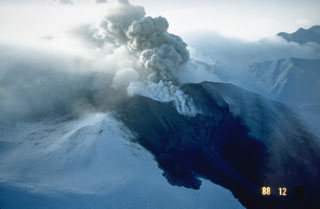
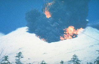 A phreatomagmatic explosion on 25 December 1988 at Japan's Tokachi volcano ejects incandescent blocks and a dark ash cloud. At the base of the ash plume is the leading edge of a small pyroclastic surge that eventually traveled down the N flank to 1 km from the vent. The 1988 eruption began with a phreatic explosion on 16 December. Intermittent explosive eruptions with small pyroclastic flows and surges began on 19 December and continued until 5 March 1989.
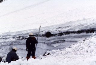 Snowpack on the western flank of Tokachi preserves individual layers of pyroclastic surge and pyroclastic flow deposits from the 1988-89 eruption. Because the eruptions took place during the winter, snowfall proved very useful to scientists in distinguishing the deposits of small-scale eruptions that lasted only a very short time.
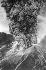 An ash plume erupts from Tokachidake on 30 June 1962. A phreatic explosion on 29 June killed five sulfur mine workers and was followed by a magmatic eruption three hours later. It continued for 11 hours, producing a 12-km-high ash plume. Weak eruptions continued intermittently until September.
 The following 9 samples associated with this volcano can be found in the Smithsonian's NMNH Department of Mineral Sciences collections, and may be availble for research (contact the Rock and Ore Collections Manager). Catalog number links will open a window with more information.
| Catalog Number | Sample Description | Lava Source | Collection Date |
|---|---|---|---|
| NMNH 112878 | Pyroxene Basalt | -- | -- |
| NMNH 112878 | Pyroxene Basalt | -- | -- |
| NMNH 112879 | Andesite | -- | -- |
| NMNH 112879 | Andesite | -- | -- |
| NMNH 112880 | Andesite | -- | -- |
| NMNH 112880 | Andesite | -- | -- |
| NMNH 112881 | Andesite | -- | -- |
| NMNH 112881 | Andesite | -- | -- |
| NMNH 112969 | Sulfur | -- | -- |
| Copernicus Browser | The Copernicus Browser replaced the Sentinel Hub Playground browser in 2023, to provide access to Earth observation archives from the Copernicus Data Space Ecosystem, the main distribution platform for data from the EU Copernicus missions. |
| MIROVA | Middle InfraRed Observation of Volcanic Activity (MIROVA) is a near real time volcanic hot-spot detection system based on the analysis of MODIS (Moderate Resolution Imaging Spectroradiometer) data. In particular, MIROVA uses the Middle InfraRed Radiation (MIR), measured over target volcanoes, in order to detect, locate and measure the heat radiation sourced from volcanic activity. |
| MODVOLC Thermal Alerts | Using infrared satellite Moderate Resolution Imaging Spectroradiometer (MODIS) data, scientists at the Hawai'i Institute of Geophysics and Planetology, University of Hawai'i, developed an automated system called MODVOLC to map thermal hot-spots in near real time. For each MODIS image, the algorithm automatically scans each 1 km pixel within it to check for high-temperature hot-spots. When one is found the date, time, location, and intensity are recorded. MODIS looks at every square km of the Earth every 48 hours, once during the day and once during the night, and the presence of two MODIS sensors in space allows at least four hot-spot observations every two days. Each day updated global maps are compiled to display the locations of all hot spots detected in the previous 24 hours. There is a drop-down list with volcano names which allow users to 'zoom-in' and examine the distribution of hot-spots at a variety of spatial scales. |
|
WOVOdat
Single Volcano View Temporal Evolution of Unrest Side by Side Volcanoes |
WOVOdat is a database of volcanic unrest; instrumentally and visually recorded changes in seismicity, ground deformation, gas emission, and other parameters from their normal baselines. It is sponsored by the World Organization of Volcano Observatories (WOVO) and presently hosted at the Earth Observatory of Singapore.
GVMID Data on Volcano Monitoring Infrastructure The Global Volcano Monitoring Infrastructure Database GVMID, is aimed at documenting and improving capabilities of volcano monitoring from the ground and space. GVMID should provide a snapshot and baseline view of the techniques and instrumentation that are in place at various volcanoes, which can be use by volcano observatories as reference to setup new monitoring system or improving networks at a specific volcano. These data will allow identification of what monitoring gaps exist, which can be then targeted by remote sensing infrastructure and future instrument deployments. |
| Volcanic Hazard Maps | The IAVCEI Commission on Volcanic Hazards and Risk has a Volcanic Hazard Maps database designed to serve as a resource for hazard mappers (or other interested parties) to explore how common issues in hazard map development have been addressed at different volcanoes, in different countries, for different hazards, and for different intended audiences. In addition to the comprehensive, searchable Volcanic Hazard Maps Database, this website contains information about diversity of volcanic hazard maps, illustrated using examples from the database. This site is for educational purposes related to volcanic hazard maps. Hazard maps found on this website should not be used for emergency purposes. For the most recent, official hazard map for a particular volcano, please seek out the proper institutional authorities on the matter. |
| IRIS seismic stations/networks | Incorporated Research Institutions for Seismology (IRIS) Data Services map showing the location of seismic stations from all available networks (permanent or temporary) within a radius of 0.18° (about 20 km at mid-latitudes) from the given location of Tokachidake. Users can customize a variety of filters and options in the left panel. Note that if there are no stations are known the map will default to show the entire world with a "No data matched request" error notice. |
| UNAVCO GPS/GNSS stations | Geodetic Data Services map from UNAVCO showing the location of GPS/GNSS stations from all available networks (permanent or temporary) within a radius of 20 km from the given location of Tokachidake. Users can customize the data search based on station or network names, location, and time window. Requires Adobe Flash Player. |
| DECADE Data | The DECADE portal, still in the developmental stage, serves as an example of the proposed interoperability between The Smithsonian Institution's Global Volcanism Program, the Mapping Gas Emissions (MaGa) Database, and the EarthChem Geochemical Portal. The Deep Earth Carbon Degassing (DECADE) initiative seeks to use new and established technologies to determine accurate global fluxes of volcanic CO2 to the atmosphere, but installing CO2 monitoring networks on 20 of the world's 150 most actively degassing volcanoes. The group uses related laboratory-based studies (direct gas sampling and analysis, melt inclusions) to provide new data for direct degassing of deep earth carbon to the atmosphere. |
| Large Eruptions of Tokachidake | Information about large Quaternary eruptions (VEI >= 4) is cataloged in the Large Magnitude Explosive Volcanic Eruptions (LaMEVE) database of the Volcano Global Risk Identification and Analysis Project (VOGRIPA). |
| EarthChem | EarthChem develops and maintains databases, software, and services that support the preservation, discovery, access and analysis of geochemical data, and facilitate their integration with the broad array of other available earth science parameters. EarthChem is operated by a joint team of disciplinary scientists, data scientists, data managers and information technology developers who are part of the NSF-funded data facility Integrated Earth Data Applications (IEDA). IEDA is a collaborative effort of EarthChem and the Marine Geoscience Data System (MGDS). |

