On 13 September, SVERT reported that strong steam-and-gas activity from Ekarma continued. Ekarma does not have a seismic network; satellite image analysis and infrequent ground observations are the primary tool for monitoring many of the Kuril Islands volcanoes.
Source: Sakhalin Volcanic Eruption Response Team (SVERT)
Kuril Island stratovolcano erupts starting June 2010
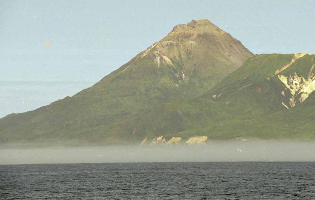
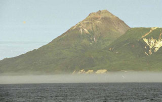
Ekarma, located in the Northern Kurile Islands, generated a modest flank eruption on 30 June 2010 after weeks of emitting steam plumes from the summit and from areas on the same SW flank where the eruption ultimately vented ash. Beginning on 16 June, witnesses 42 km away heard anomalous booming noises. Regional maps and supplementary information appear in a subsection below. Figure 1 contains a photo of Ekarma taken in 2008. Information summarized here and below came from a recent report (Levin and others, 2010) submitted by Alexandr V. Rybin, who is the director of the Sakhalin Volcanic Eruption Response Team (SVERT) and served as group leader on the international volcanology expedition mounted in August 2010.
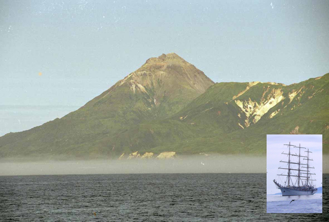 |
Figure 1. Pre-eruptive view of Ekarma captured in August 2008 from the SE that illustrates the summit's jagged profile, the result of an extrusive summit dome that forms the volcano's rocky barren upper slopes. To the right of the cone sit parts of the ancient and now hydrothermally altered volcanic edifice. (Lower right) Majestic Nadezhda sitting at anchor in deep water as necessitated by its 7.3 m draft (vessel's extent below waterline). From anchorages like this, scientists accessed the adjacent islands via inflatable boats with outboard motors. Courtesy of A. Rybin (SVERT). |
A few of the available photos documenting the escalating plumes are included in this report. The tallest plume seen reached ~3 km altitude. Steaming or weakened eruption continued in August when volcanologists first set foot on the island. They found Ekarma had erupted from a fissure on the upper SW slopes (at 500- to 600-m elevation). Fine ash reached up to 5-6 cm deep in some places. Fresh ash-bearing lahars had developed along SW-flank drainages. The volcano was still steaming in late September 2010.
Levin and others (2010) described Ekarma's state during two time intervals and by two separate groups in mid-2010. One group, biologists, working on a neighboring island during 28 May-11 July 2010 first noticed a multi-week escalation of steaming at multiple vents, heard noises, and then saw the initial ash-bearing eruption on 30 June 2010. Another group, volcanologists, both saw the eruption from distance and landed on the still-active volcano in early August. This team sailed into the region on the oceanographic vessel Nadezhda (figure 1). Report authors were listed as follows: Levin, B.V., Rybin, A.V., Chibisova, M.V., Degterev, A.V., Neroda, A.S., Melekestsev, I.V., and Izbekov, P.E. (see affiliations below under Information Contacts).
Ekarma is a single stratovolcano formed by numerous lava flows. Many of the flows exposed at the surface reach up to ~3 km length and reached the coast to form resistant lobate promontories. Until this recent eruption, all the known eruptions vented from the summit crater. The last of the lava flows was viscous, of fan-like form, and it descended to the W. After the lava flows, a lava plug extruded at the summit forming the spiny relief there that remains today. Gorshkov (1967) found this extrusion occurred during 1767-1769, this comprising the volcano's oldest known historical eruptive date. In the first half of 19th century, fumarolic activity was observed at the volcano. At the beginning and middle of the 20th century, the pattern of fumarolic activity varied (Gorshkov, 1967).
One other pre-2010 eruption is known. On 24 May 1980 observers on a passing ship noted a series of explosions lasting an hour. The resulting black eruptive column reached an altitude of over 1 km (Ivanov and others, 1981).
A plume was not apparent on photos from 1992. After receipt of this report, Bulletin editors found photos of Ekarma on Google Earth and the photo-sharing website Panoramio. They were taken in 1992 by Edward Ivey from distance. Correspondence with Ivey confirmed that he did not recall seeing any memorable signs of unrest at Ekarma.
The report authors looked at satellite images collected during the years 2000-2008 from sources offering free image-access on the internet. In those images, the authors found that fumarolic steaming from the summit varied. Quiet prevailed in 2007 or 2008 when scientists on passing a research ship scientists saw the volcano and documented an absence of fumarolic activity (Levin and others, 2009).
June 2010 observations made 42 km away. The information in Levin and others (2010) about Ekarma's observed eruptive behavior during June came from Andrey S. Neroda (Pacific Oceanographic Institute FEB RAS), who along with fellow researchers watched the volcano during 28 May-11 July 2010. They were in the region conducting population studies on sea lions on Skala Dolgaya Island (in the Lovushki Islands). That vantage point (the location of their photos) lies ~42 km SW of Ekarma Island.
The biologists first noticed higher steam-gas emissions at the volcano at the beginning of June. On 13 June there emerged three isolated points of strong steam emission (vigorous fumaroles) on the S slope and summit. In the latter half of 16 June the group on Skala Dlinnaya Island heard booming noises. The sounds occurred 8-10 times in a time interval lasting 30-40 minutes. In the next days the team heard other, softer noises. The 18 June steam plumes were similar to those on the 13th. A prominent white cloud judged as a plume stood over the summit on the 29th. Three distinct steam plumes emerged on 30 June (figure 2), and the same day the ash-bearing phase occurred.
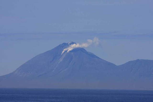 |
Figure 2. On 30 June 2010 biologists ~42 km SW watched as Ekarma began to emit larger steam plumes in prelude to an ash-bearing eruption. In this photo, the plume from the upper (summit dome) is weaker than the other two fumarolic vents but clearly visible. Photo Andrey Neroda. |
In the evening of 30 June observers began to see volcanic explosions with emission of ash up to 3 km altitude. No ash fall was detected on Skala Dolgaya Island. In addition to the photos, the same witnesses took some low-resolution video on 30 June. Three lahars went down from the vent area of the middle venting site, one trending S, the other two roughly SW.
The August expedition put to sea on the 109-m-long, 3-masted, square-rigged ship Nadezhda. The Nadezhda serves the Nevelskoy Maritime State University (Vladivostok, Russian Far Eastern Federal District) and to sail her requires a crew of 50 persons.
Levin and others (2010) reported that eruptions continued as the Nadezhda approached Ekarma. The team had initially set out with the primary intent of visiting Sarychev Peak and the adjacent volcano and island, Raikoke, but during the expedition they learned of increasing activity at Ekarma and revised plans in order to visit there as well.
On 10 August 2010 observers saw an Ekarma plume from their anchorage between Raikoke and Matua Islands ~90 km SW of Ekarma. The plume was sustained all day on the 10th, described as a steam-gas column light gray in color and reaching ~2 km altitude. In similar manner to the June observations, the vent discharging the emissions was not at the 1,170-m summit but on the SW flank at elevation of 500-600 m.
During 11-23 August, the expedition worked at Matua Island (Dvoinaya Bay, studying Sarychev Peak), watching Ekarma from 105 km SW. During this period visibility was sufficient on the days 14 and 22 August to enable observers to see smaller steam-gas columns that rose to 1.6 km altitude. Nadezhda left Matua Island on 24 August. On Ekarma, the team found the volcano and surroundings tephra covered. With distance from the active vent, the fine gray airfall ash decreased in thickness and became finer grained.
At the elevation of ~300 m the team found the ash 1-2 mm thick; in the near-summit part of the volcano at ~900 m elevation, they found it 4-6 cm thick and bearing some coarser-grained components. Small lahars had descended along the volcano's southern slope down to the sea (figure 3).
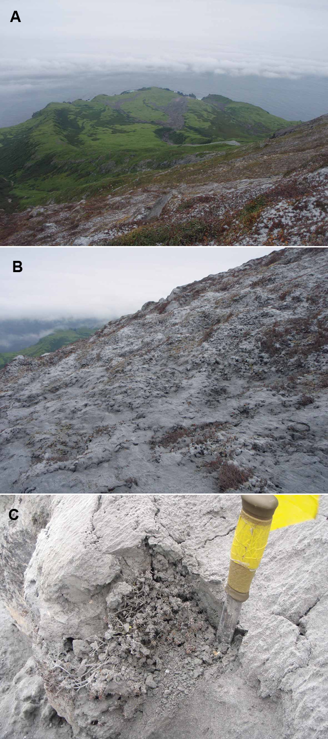 |
Figure 3. Some consequences of the eruption on Ekarma volcano as seen in photographs taken 24 August 2010. (A) In the foreground one can see scattered preserved tephra partially covering vegetation; in the distance one can see dark zones where water, ash, and other debris were swept downslope as lahars that descended during the eruption. (B) A view of ash found Ekarma's middle to upper slopes. (C) Close up view of a thicker, near-vent area of ash accumulation. Here the ash fully covered low-lying plants. Plant and soil damage are discussed in text. Photos taken by Ekaterina Kravchunovskaya. |
The eruption influenced the island's flora. At 250-300 m elevation the plants began to display signs of stress. At ~550 m and higher elevation most of the smaller plants had dried up, and larger bushes (willow, alder) showed distinct signs of influence such as dried leaves due to contact with ash and related impacts of the eruption.
Authors suggested that the main factor influencing plant damage was not the high temperature of tephra, because tephra of such fine-grain size falls from the air with little residual heat. Instead, chemical burns from volcanic gases and water-soluble condensate were interpreted to have caused the damage. Many of the damaged plants were expected to rebound in the next growing season. Along drainages where lahars descended, the soil-vegetative layer was sometimes destroyed.
After the expedition, steam-and-gas emissions continued into at least late September. For example, an image of the island from the QuickBird satellite taken 20 September 2010 shows a wisp of white plume over the upper slopes (figure 4).
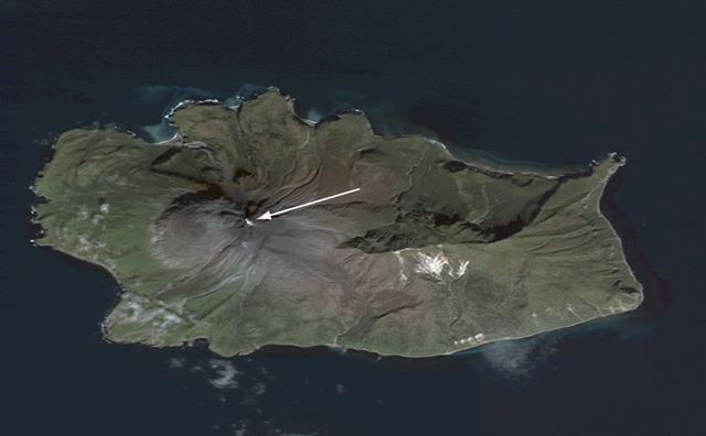 |
Figure 4. A photo of Ekarma Island taken from the QuickBird satellite on 20 September 2010. N is towards the top; the island is 5 x 7.5 km in size. The elongate arrow is aimed at a small white plume found over Ekarma's upper slopes. By this time, Ekarma had also developed lahars descending both the N and S flanks. Courtesy of the authors and QuickBird (2010) [Image's catalog ID, 101001000C504F00; sensor, QB02; band, Pan_MS1]. |
On figure 4 steam-gas emissions appeared limited to the 2010 vent and upper areas of the volcano. Earlier observations had documented S flank lahars. Based in part on water discoloration assumed to come from suspended particles transported by near-shore currents, lahars by this time had also descended along the N flanks (and possibly down other island drainages as well). An International Space Station photo of the volcano is also available from the same day showing a similar plume, but much of the surrounding scene is masked by clouds.
Levin and others (2010) made a preliminary volume estimate for the erupted material, 2 x 10⁵ m3. They noted that this would place the eruption's volcano explosivity index (VEI) at 1 (Siebert et al, 2010).
Figure 5 shows Ekarma's location, and although this region is both remote and sparsely inhabited, this volcanic chain lies beneath, alongside, and frequently upwind of major North Pacific aviation routes, corridors that in 1998 served more than 20,000 passengers and millions of pounds of cargo on a daily basis (Miller and Casadevall, 2000). For a recently issued compilation of known aircraft-ash incidents, see Guffanti and others (2010).
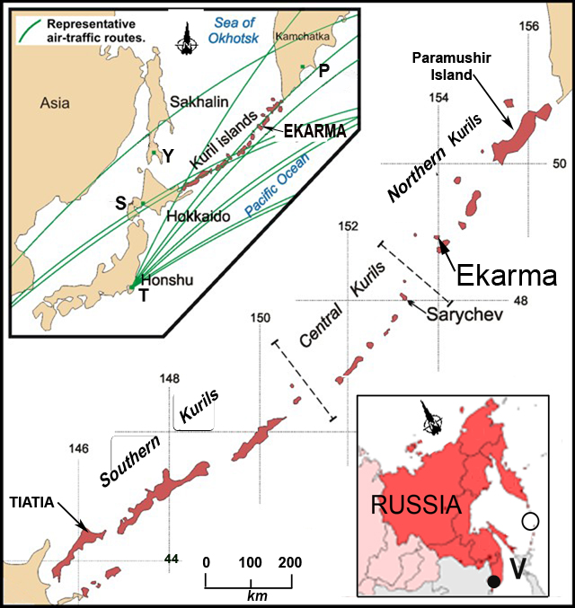 |
Figure 5. A photo of Ekarma Island taken from the QuickBird satellite on 20 September 2010. N is towards the top; the island is 5 x 7.5 km in size. The elongate arrow is aimed at a small white plume found over Ekarma's upper slopes. By this time, Ekarma had also developed lahars descending both the N and S flanks. Courtesy of the authors and QuickBird (2010) [Image's catalog ID, 101001000C504F00; sensor, QB02; band, Pan_MS1]. |
To help illustrate regional geography, Ekarma lies 880 km E of Vladivostok (V on the inset map at lower right). On the map at upper left, labeled cities are Y, Yuzhno-Sakhalinsk, S, Sapporo, P, Petropavlovsk-Kamchatsky, and T, Tokyo (~1,500 km SW of Ekarma).
Ekarma's June 2010 eruption began months after that of Iceland's Eyjafjallajökull (BGVN 35:03 and 35:04), and ash plumes from that eruption severely restricted European air traffic for a week. That disruptive event enlightened many in the public about the hazards of ash and aviation. In contrast to that eruption, the one at Ekarma failed to generate large, tall eruption plumes, and thus produced relatively little if any aviation impact. Ekarma's reported plume heights only reached as high as 3 km altitude, whereas most commercial aircraft cruse at altitudes ~4-fold higher. Still, volcanoes of the Kurile Islands occur close to the flight lines radiating from Asian population centers (figure 5, upper left). They also present aviation challenges in that they collectively lack in situ monitoring instrumentation, and they are generally devoid of residents to observe and alert authorities of eruptions.
References. Casadevall, T., and Thompson, T., 1995, World map of volcanoes and principal aeronautical features (1:34,268,000 at equator): U.S. Geological Survey, Geophysical Investigations Map GP 1011 (Mercator projection)
Gorshkov, G.S., 1967, Volcanism of the Kurile Island arc. Nauka, Moscow
Ivanov B.V., Chirkov A.M., Dubik Yu.M., Gavrilov V.A., Stepanov V.V., Rulenko O.P., and Firstov P.P., 1981, The State of the volcanoes of Kamchatka and the Kurile Islands in 1980. Volcanology and seismology, 1981. 3. P. 99-104.
Guffanti, M., Casadevall, T.J., and Budding, K., 2010, Encounters of aircraft with volcanic ash clouds; A compilation of known incidents, 1953–2009: U.S. Geological Survey Data Series 545, ver. 1.0, 12 p., plus four appendixes including the compilation database. URL: http://pubs.usgs.gov/ds/545
QuickBird, 2010 [satellite image distributed by Digital Globe, digitalglobe.com, http://browse.digitalglobe.com/]; Image's current URL: http://browse.digitalglobe.com/imagefinder/showBrowseMetadata?catalogId=101001000C504F00
Levin B.V., Fitzhugh B., Bourgeois D., and others, 2009, Complex expedition in the Kurile Island in 2008 (III stage), Vestnik of Far East Branch of Russian Academy of Sciences, 2, p. 134-142.
Siebert, L., Simkin T.S. and Kimberly, P., 2010, Volcanoes of the World: a regional directory, gazetteer, and chronology of volcanism during the last 10,000 years, 3rd edition, University of California Press, Berkeley, CA, 551 p.
Levin, BV, Rybin, AV, Chibisova, MV, Degterev, AV, Neroda AS, Melekestsev, IV, and Izbekov, PE, 2010, Activity increasing of Ekarma volcano in June 2010 (informal report submitted to BGVN).
Miller, T. P., and Casadevall, T. J., 2000, Volcanic ash hazards to aviation: in Sigurdsson, Haraldur, (ed.), Encyclopedia of Volcanoes, San Diego, Academic Press, p. 915-930.
Information Contacts: B.V. Levin, A.V. Rybin, M.V. Chibisova, A.V. Degterev, Sakhalin volcanic eruption response team (SVERT), Institute of Marine Geology and Geophysics FEB RAS (IMGG FEB RAS), 693022, Russia, Yuzhno-Sakhalinsk, Nauki str. 1B (URL: http://www.imgg.ru/); A.S. Neroda, Pacific Oceanological Institute FEB RAS (POI FEB RAS) 690041, Russia, Vladivostok, Baltiiskaya str. 43 (URL: http://www.poi.dvo.ru/rus/index.html); I.V. Melekestsev, Institute of volcanology and seismology FEB RAS (IVS FEB RAS) 683006, Russia, Petropavlovsk-Kamchatsky, Piipa av. 9. (URL: http://www.kscnet.ru/ivs/); P.E. Izbekov, Geophysical Institute, University of Alaska Fairbanks, 903 Koyukuk Drive, Fairbanks, AK 99775, USA.
On 13 September, SVERT reported that strong steam-and-gas activity from Ekarma continued. Ekarma does not have a seismic network; satellite image analysis and infrequent ground observations are the primary tool for monitoring many of the Kuril Islands volcanoes.
Source: Sakhalin Volcanic Eruption Response Team (SVERT)
On 6 September, SVERT reported that strong steam-and-gas activity from Ekarma continued. Ekarma does not have a seismic network; satellite image analysis and infrequent ground observations are the primary tool for monitoring many of the Kuril Islands volcanoes.
Source: Sakhalin Volcanic Eruption Response Team (SVERT)
SVERT reported that on 10 August scientists observed a vigorous steam plume from Ekarma that rose to an altitude of 1.8 km (5,900 ft) a.s.l. while visiting Sarychev Peak, 110 km SSW. On 24 August scientists visited Ekarma Island and observed continuous vigorous gas emissions from a new vent located on the S flank, about 250 m below the summit. The flanks had been blanketed by a layer of fine ash with a thickness exceeding 5 cm in the vicinity of the vent. Two recent lahar deposits were seen on the S flank. Based on their observations, SVERT speculated that a small eruption may have occurred between early June and late July 2010. Ekarma does not have a seismic network; satellite image analysis and infrequent ground observations are the primary tool for monitoring many of the Kuril Islands volcanoes.
Source: Sakhalin Volcanic Eruption Response Team (SVERT)
Reports are organized chronologically and indexed below by Month/Year (Publication Volume:Number), and include a one-line summary. Click on the index link or scroll down to read the reports.
Explosions and a black eruption column; ashfall
Explosions were observed from a passing fishing boat on 24 May 1980. A black eruption column rose to about 1 km height, and ash fell on the ship. Ekarma's slopes were dark gray while those of nearby Chirinkotan were white, as observed from 40-50 km to the SW (Ivanov and others, 1981).
Reference. Ivanov, B.V., Chirkov, A., Dubik, Yu., Garilov, V.A., Stepanov, V.V., Rulenko, O.P., and Firstov, P.P., 1981, The state of volcanoes in Kamchatka and Kuril Islands in 1980: Volcanology and Seismology, no. 3, p. 99-104.
Information Contacts: See Reference.
Kuril Island stratovolcano erupts starting June 2010
Ekarma, located in the Northern Kurile Islands, generated a modest flank eruption on 30 June 2010 after weeks of emitting steam plumes from the summit and from areas on the same SW flank where the eruption ultimately vented ash. Beginning on 16 June, witnesses 42 km away heard anomalous booming noises. Regional maps and supplementary information appear in a subsection below. Figure 1 contains a photo of Ekarma taken in 2008. Information summarized here and below came from a recent report (Levin and others, 2010) submitted by Alexandr V. Rybin, who is the director of the Sakhalin Volcanic Eruption Response Team (SVERT) and served as group leader on the international volcanology expedition mounted in August 2010.
|
Figure 1. Pre-eruptive view of Ekarma captured in August 2008 from the SE that illustrates the summit's jagged profile, the result of an extrusive summit dome that forms the volcano's rocky barren upper slopes. To the right of the cone sit parts of the ancient and now hydrothermally altered volcanic edifice. (Lower right) Majestic Nadezhda sitting at anchor in deep water as necessitated by its 7.3 m draft (vessel's extent below waterline). From anchorages like this, scientists accessed the adjacent islands via inflatable boats with outboard motors. Courtesy of A. Rybin (SVERT). |
A few of the available photos documenting the escalating plumes are included in this report. The tallest plume seen reached ~3 km altitude. Steaming or weakened eruption continued in August when volcanologists first set foot on the island. They found Ekarma had erupted from a fissure on the upper SW slopes (at 500- to 600-m elevation). Fine ash reached up to 5-6 cm deep in some places. Fresh ash-bearing lahars had developed along SW-flank drainages. The volcano was still steaming in late September 2010.
Levin and others (2010) described Ekarma's state during two time intervals and by two separate groups in mid-2010. One group, biologists, working on a neighboring island during 28 May-11 July 2010 first noticed a multi-week escalation of steaming at multiple vents, heard noises, and then saw the initial ash-bearing eruption on 30 June 2010. Another group, volcanologists, both saw the eruption from distance and landed on the still-active volcano in early August. This team sailed into the region on the oceanographic vessel Nadezhda (figure 1). Report authors were listed as follows: Levin, B.V., Rybin, A.V., Chibisova, M.V., Degterev, A.V., Neroda, A.S., Melekestsev, I.V., and Izbekov, P.E. (see affiliations below under Information Contacts).
Ekarma is a single stratovolcano formed by numerous lava flows. Many of the flows exposed at the surface reach up to ~3 km length and reached the coast to form resistant lobate promontories. Until this recent eruption, all the known eruptions vented from the summit crater. The last of the lava flows was viscous, of fan-like form, and it descended to the W. After the lava flows, a lava plug extruded at the summit forming the spiny relief there that remains today. Gorshkov (1967) found this extrusion occurred during 1767-1769, this comprising the volcano's oldest known historical eruptive date. In the first half of 19th century, fumarolic activity was observed at the volcano. At the beginning and middle of the 20th century, the pattern of fumarolic activity varied (Gorshkov, 1967).
One other pre-2010 eruption is known. On 24 May 1980 observers on a passing ship noted a series of explosions lasting an hour. The resulting black eruptive column reached an altitude of over 1 km (Ivanov and others, 1981).
A plume was not apparent on photos from 1992. After receipt of this report, Bulletin editors found photos of Ekarma on Google Earth and the photo-sharing website Panoramio. They were taken in 1992 by Edward Ivey from distance. Correspondence with Ivey confirmed that he did not recall seeing any memorable signs of unrest at Ekarma.
The report authors looked at satellite images collected during the years 2000-2008 from sources offering free image-access on the internet. In those images, the authors found that fumarolic steaming from the summit varied. Quiet prevailed in 2007 or 2008 when scientists on passing a research ship scientists saw the volcano and documented an absence of fumarolic activity (Levin and others, 2009).
June 2010 observations made 42 km away. The information in Levin and others (2010) about Ekarma's observed eruptive behavior during June came from Andrey S. Neroda (Pacific Oceanographic Institute FEB RAS), who along with fellow researchers watched the volcano during 28 May-11 July 2010. They were in the region conducting population studies on sea lions on Skala Dolgaya Island (in the Lovushki Islands). That vantage point (the location of their photos) lies ~42 km SW of Ekarma Island.
The biologists first noticed higher steam-gas emissions at the volcano at the beginning of June. On 13 June there emerged three isolated points of strong steam emission (vigorous fumaroles) on the S slope and summit. In the latter half of 16 June the group on Skala Dlinnaya Island heard booming noises. The sounds occurred 8-10 times in a time interval lasting 30-40 minutes. In the next days the team heard other, softer noises. The 18 June steam plumes were similar to those on the 13th. A prominent white cloud judged as a plume stood over the summit on the 29th. Three distinct steam plumes emerged on 30 June (figure 2), and the same day the ash-bearing phase occurred.
|
Figure 2. On 30 June 2010 biologists ~42 km SW watched as Ekarma began to emit larger steam plumes in prelude to an ash-bearing eruption. In this photo, the plume from the upper (summit dome) is weaker than the other two fumarolic vents but clearly visible. Photo Andrey Neroda. |
In the evening of 30 June observers began to see volcanic explosions with emission of ash up to 3 km altitude. No ash fall was detected on Skala Dolgaya Island. In addition to the photos, the same witnesses took some low-resolution video on 30 June. Three lahars went down from the vent area of the middle venting site, one trending S, the other two roughly SW.
The August expedition put to sea on the 109-m-long, 3-masted, square-rigged ship Nadezhda. The Nadezhda serves the Nevelskoy Maritime State University (Vladivostok, Russian Far Eastern Federal District) and to sail her requires a crew of 50 persons.
Levin and others (2010) reported that eruptions continued as the Nadezhda approached Ekarma. The team had initially set out with the primary intent of visiting Sarychev Peak and the adjacent volcano and island, Raikoke, but during the expedition they learned of increasing activity at Ekarma and revised plans in order to visit there as well.
On 10 August 2010 observers saw an Ekarma plume from their anchorage between Raikoke and Matua Islands ~90 km SW of Ekarma. The plume was sustained all day on the 10th, described as a steam-gas column light gray in color and reaching ~2 km altitude. In similar manner to the June observations, the vent discharging the emissions was not at the 1,170-m summit but on the SW flank at elevation of 500-600 m.
During 11-23 August, the expedition worked at Matua Island (Dvoinaya Bay, studying Sarychev Peak), watching Ekarma from 105 km SW. During this period visibility was sufficient on the days 14 and 22 August to enable observers to see smaller steam-gas columns that rose to 1.6 km altitude. Nadezhda left Matua Island on 24 August. On Ekarma, the team found the volcano and surroundings tephra covered. With distance from the active vent, the fine gray airfall ash decreased in thickness and became finer grained.
At the elevation of ~300 m the team found the ash 1-2 mm thick; in the near-summit part of the volcano at ~900 m elevation, they found it 4-6 cm thick and bearing some coarser-grained components. Small lahars had descended along the volcano's southern slope down to the sea (figure 3).
|
Figure 3. Some consequences of the eruption on Ekarma volcano as seen in photographs taken 24 August 2010. (A) In the foreground one can see scattered preserved tephra partially covering vegetation; in the distance one can see dark zones where water, ash, and other debris were swept downslope as lahars that descended during the eruption. (B) A view of ash found Ekarma's middle to upper slopes. (C) Close up view of a thicker, near-vent area of ash accumulation. Here the ash fully covered low-lying plants. Plant and soil damage are discussed in text. Photos taken by Ekaterina Kravchunovskaya. |
The eruption influenced the island's flora. At 250-300 m elevation the plants began to display signs of stress. At ~550 m and higher elevation most of the smaller plants had dried up, and larger bushes (willow, alder) showed distinct signs of influence such as dried leaves due to contact with ash and related impacts of the eruption.
Authors suggested that the main factor influencing plant damage was not the high temperature of tephra, because tephra of such fine-grain size falls from the air with little residual heat. Instead, chemical burns from volcanic gases and water-soluble condensate were interpreted to have caused the damage. Many of the damaged plants were expected to rebound in the next growing season. Along drainages where lahars descended, the soil-vegetative layer was sometimes destroyed.
After the expedition, steam-and-gas emissions continued into at least late September. For example, an image of the island from the QuickBird satellite taken 20 September 2010 shows a wisp of white plume over the upper slopes (figure 4).
|
Figure 4. A photo of Ekarma Island taken from the QuickBird satellite on 20 September 2010. N is towards the top; the island is 5 x 7.5 km in size. The elongate arrow is aimed at a small white plume found over Ekarma's upper slopes. By this time, Ekarma had also developed lahars descending both the N and S flanks. Courtesy of the authors and QuickBird (2010) [Image's catalog ID, 101001000C504F00; sensor, QB02; band, Pan_MS1]. |
On figure 4 steam-gas emissions appeared limited to the 2010 vent and upper areas of the volcano. Earlier observations had documented S flank lahars. Based in part on water discoloration assumed to come from suspended particles transported by near-shore currents, lahars by this time had also descended along the N flanks (and possibly down other island drainages as well). An International Space Station photo of the volcano is also available from the same day showing a similar plume, but much of the surrounding scene is masked by clouds.
Levin and others (2010) made a preliminary volume estimate for the erupted material, 2 x 10⁵ m3. They noted that this would place the eruption's volcano explosivity index (VEI) at 1 (Siebert et al, 2010).
Figure 5 shows Ekarma's location, and although this region is both remote and sparsely inhabited, this volcanic chain lies beneath, alongside, and frequently upwind of major North Pacific aviation routes, corridors that in 1998 served more than 20,000 passengers and millions of pounds of cargo on a daily basis (Miller and Casadevall, 2000). For a recently issued compilation of known aircraft-ash incidents, see Guffanti and others (2010).
|
Figure 5. A photo of Ekarma Island taken from the QuickBird satellite on 20 September 2010. N is towards the top; the island is 5 x 7.5 km in size. The elongate arrow is aimed at a small white plume found over Ekarma's upper slopes. By this time, Ekarma had also developed lahars descending both the N and S flanks. Courtesy of the authors and QuickBird (2010) [Image's catalog ID, 101001000C504F00; sensor, QB02; band, Pan_MS1]. |
To help illustrate regional geography, Ekarma lies 880 km E of Vladivostok (V on the inset map at lower right). On the map at upper left, labeled cities are Y, Yuzhno-Sakhalinsk, S, Sapporo, P, Petropavlovsk-Kamchatsky, and T, Tokyo (~1,500 km SW of Ekarma).
Ekarma's June 2010 eruption began months after that of Iceland's Eyjafjallajökull (BGVN 35:03 and 35:04), and ash plumes from that eruption severely restricted European air traffic for a week. That disruptive event enlightened many in the public about the hazards of ash and aviation. In contrast to that eruption, the one at Ekarma failed to generate large, tall eruption plumes, and thus produced relatively little if any aviation impact. Ekarma's reported plume heights only reached as high as 3 km altitude, whereas most commercial aircraft cruse at altitudes ~4-fold higher. Still, volcanoes of the Kurile Islands occur close to the flight lines radiating from Asian population centers (figure 5, upper left). They also present aviation challenges in that they collectively lack in situ monitoring instrumentation, and they are generally devoid of residents to observe and alert authorities of eruptions.
References. Casadevall, T., and Thompson, T., 1995, World map of volcanoes and principal aeronautical features (1:34,268,000 at equator): U.S. Geological Survey, Geophysical Investigations Map GP 1011 (Mercator projection)
Gorshkov, G.S., 1967, Volcanism of the Kurile Island arc. Nauka, Moscow
Ivanov B.V., Chirkov A.M., Dubik Yu.M., Gavrilov V.A., Stepanov V.V., Rulenko O.P., and Firstov P.P., 1981, The State of the volcanoes of Kamchatka and the Kurile Islands in 1980. Volcanology and seismology, 1981. 3. P. 99-104.
Guffanti, M., Casadevall, T.J., and Budding, K., 2010, Encounters of aircraft with volcanic ash clouds; A compilation of known incidents, 1953–2009: U.S. Geological Survey Data Series 545, ver. 1.0, 12 p., plus four appendixes including the compilation database. URL: http://pubs.usgs.gov/ds/545
QuickBird, 2010 [satellite image distributed by Digital Globe, digitalglobe.com, http://browse.digitalglobe.com/]; Image's current URL: http://browse.digitalglobe.com/imagefinder/showBrowseMetadata?catalogId=101001000C504F00
Levin B.V., Fitzhugh B., Bourgeois D., and others, 2009, Complex expedition in the Kurile Island in 2008 (III stage), Vestnik of Far East Branch of Russian Academy of Sciences, 2, p. 134-142.
Siebert, L., Simkin T.S. and Kimberly, P., 2010, Volcanoes of the World: a regional directory, gazetteer, and chronology of volcanism during the last 10,000 years, 3rd edition, University of California Press, Berkeley, CA, 551 p.
Levin, BV, Rybin, AV, Chibisova, MV, Degterev, AV, Neroda AS, Melekestsev, IV, and Izbekov, PE, 2010, Activity increasing of Ekarma volcano in June 2010 (informal report submitted to BGVN).
Miller, T. P., and Casadevall, T. J., 2000, Volcanic ash hazards to aviation: in Sigurdsson, Haraldur, (ed.), Encyclopedia of Volcanoes, San Diego, Academic Press, p. 915-930.
Information Contacts: B.V. Levin, A.V. Rybin, M.V. Chibisova, A.V. Degterev, Sakhalin volcanic eruption response team (SVERT), Institute of Marine Geology and Geophysics FEB RAS (IMGG FEB RAS), 693022, Russia, Yuzhno-Sakhalinsk, Nauki str. 1B (URL: http://www.imgg.ru/); A.S. Neroda, Pacific Oceanological Institute FEB RAS (POI FEB RAS) 690041, Russia, Vladivostok, Baltiiskaya str. 43 (URL: http://www.poi.dvo.ru/rus/index.html); I.V. Melekestsev, Institute of volcanology and seismology FEB RAS (IVS FEB RAS) 683006, Russia, Petropavlovsk-Kamchatsky, Piipa av. 9. (URL: http://www.kscnet.ru/ivs/); P.E. Izbekov, Geophysical Institute, University of Alaska Fairbanks, 903 Koyukuk Drive, Fairbanks, AK 99775, USA.
|
|
||||||||||||||||||||||||||
There is data available for 3 confirmed eruptive periods.
2010 Jun 30 - 2010 Aug 10 (?) Confirmed Eruption (Explosive / Effusive) VEI: 2
| Episode 1 | Eruption (Explosive / Effusive) | Upper SW flank | ||||||||||||||||||||||||||||||||||||||||||||||||
|---|---|---|---|---|---|---|---|---|---|---|---|---|---|---|---|---|---|---|---|---|---|---|---|---|---|---|---|---|---|---|---|---|---|---|---|---|---|---|---|---|---|---|---|---|---|---|---|---|---|
| 2010 Jun 30 - 2010 Aug 10 (?) | Evidence from Observations: Reported | ||||||||||||||||||||||||||||||||||||||||||||||||
|
List of 8 Events for Episode 1 at Upper SW flank
|
|||||||||||||||||||||||||||||||||||||||||||||||||
1980 May 24 Confirmed Eruption (Explosive / Effusive) VEI: 1
| Episode 1 | Eruption (Explosive / Effusive) | |||||||||||||||||||
|---|---|---|---|---|---|---|---|---|---|---|---|---|---|---|---|---|---|---|---|
| 1980 May 24 - Unknown | Evidence from Observations: Reported | ||||||||||||||||||
|
List of 2 Events for Episode 1
|
|||||||||||||||||||
1767 - 1769 Confirmed Eruption (Explosive / Effusive) VEI: 2
| Episode 1 | Eruption (Explosive / Effusive) | Summit dome | |||||||||||||||||||||||
|---|---|---|---|---|---|---|---|---|---|---|---|---|---|---|---|---|---|---|---|---|---|---|---|---|
| 1767 - 1769 | Evidence from Observations: Reported | |||||||||||||||||||||||
|
List of 3 Events for Episode 1 at Summit dome
|
||||||||||||||||||||||||
This compilation of synonyms and subsidiary features may not be comprehensive. Features are organized into four major categories: Cones, Craters, Domes, and Thermal Features. Synonyms of features appear indented below the primary name. In some cases additional feature type, elevation, or location details are provided.
Synonyms |
| Ikarma | Ekaruma |
 Ekarma with its summit lava dome rises above the sea with an older hydrothermally altered volcanic edifice to the right. The small 5 x 7.5 km island lies 8.5 km N of Shiashkotan Island in the central Kuriles. The summit lava dome was emplaced during the first historical eruption in 1776-79.
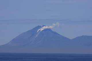 On 30 June 2010, biologists located about ~42 km SW of Ekarma watched as it began to emit large steam-and-gas plumes that were precursory to an eruption. In this photo, the upper plume from the summit dome is weaker than the other two vents but clearly visible. An ash plume erupted from a vent on the upper SW flank later that day and rose to about 3 km altitude.
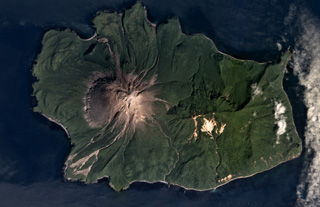 The 5.5 x 8 km Ekarma Island of the Kurile Islands is shown in this August 2017 Planet Labs satellite image monthly mosaic (N is at the top). The volcano forms the western side of the island, with flanks composed of lava flows out to 3 km in all directions and pyroclastic deposits between them. The summit crater has been filled with a lava dome that forms the summit of the cone.
There are no samples for Ekarma in the Smithsonian's NMNH Department of Mineral Sciences Rock and Ore collection.
| Copernicus Browser | The Copernicus Browser replaced the Sentinel Hub Playground browser in 2023, to provide access to Earth observation archives from the Copernicus Data Space Ecosystem, the main distribution platform for data from the EU Copernicus missions. |
| MIROVA | Middle InfraRed Observation of Volcanic Activity (MIROVA) is a near real time volcanic hot-spot detection system based on the analysis of MODIS (Moderate Resolution Imaging Spectroradiometer) data. In particular, MIROVA uses the Middle InfraRed Radiation (MIR), measured over target volcanoes, in order to detect, locate and measure the heat radiation sourced from volcanic activity. |
| MODVOLC Thermal Alerts | Using infrared satellite Moderate Resolution Imaging Spectroradiometer (MODIS) data, scientists at the Hawai'i Institute of Geophysics and Planetology, University of Hawai'i, developed an automated system called MODVOLC to map thermal hot-spots in near real time. For each MODIS image, the algorithm automatically scans each 1 km pixel within it to check for high-temperature hot-spots. When one is found the date, time, location, and intensity are recorded. MODIS looks at every square km of the Earth every 48 hours, once during the day and once during the night, and the presence of two MODIS sensors in space allows at least four hot-spot observations every two days. Each day updated global maps are compiled to display the locations of all hot spots detected in the previous 24 hours. There is a drop-down list with volcano names which allow users to 'zoom-in' and examine the distribution of hot-spots at a variety of spatial scales. |
|
WOVOdat
Single Volcano View Temporal Evolution of Unrest Side by Side Volcanoes |
WOVOdat is a database of volcanic unrest; instrumentally and visually recorded changes in seismicity, ground deformation, gas emission, and other parameters from their normal baselines. It is sponsored by the World Organization of Volcano Observatories (WOVO) and presently hosted at the Earth Observatory of Singapore.
GVMID Data on Volcano Monitoring Infrastructure The Global Volcano Monitoring Infrastructure Database GVMID, is aimed at documenting and improving capabilities of volcano monitoring from the ground and space. GVMID should provide a snapshot and baseline view of the techniques and instrumentation that are in place at various volcanoes, which can be use by volcano observatories as reference to setup new monitoring system or improving networks at a specific volcano. These data will allow identification of what monitoring gaps exist, which can be then targeted by remote sensing infrastructure and future instrument deployments. |
| Volcanic Hazard Maps | The IAVCEI Commission on Volcanic Hazards and Risk has a Volcanic Hazard Maps database designed to serve as a resource for hazard mappers (or other interested parties) to explore how common issues in hazard map development have been addressed at different volcanoes, in different countries, for different hazards, and for different intended audiences. In addition to the comprehensive, searchable Volcanic Hazard Maps Database, this website contains information about diversity of volcanic hazard maps, illustrated using examples from the database. This site is for educational purposes related to volcanic hazard maps. Hazard maps found on this website should not be used for emergency purposes. For the most recent, official hazard map for a particular volcano, please seek out the proper institutional authorities on the matter. |
| IRIS seismic stations/networks | Incorporated Research Institutions for Seismology (IRIS) Data Services map showing the location of seismic stations from all available networks (permanent or temporary) within a radius of 0.18° (about 20 km at mid-latitudes) from the given location of Ekarma. Users can customize a variety of filters and options in the left panel. Note that if there are no stations are known the map will default to show the entire world with a "No data matched request" error notice. |
| UNAVCO GPS/GNSS stations | Geodetic Data Services map from UNAVCO showing the location of GPS/GNSS stations from all available networks (permanent or temporary) within a radius of 20 km from the given location of Ekarma. Users can customize the data search based on station or network names, location, and time window. Requires Adobe Flash Player. |
| DECADE Data | The DECADE portal, still in the developmental stage, serves as an example of the proposed interoperability between The Smithsonian Institution's Global Volcanism Program, the Mapping Gas Emissions (MaGa) Database, and the EarthChem Geochemical Portal. The Deep Earth Carbon Degassing (DECADE) initiative seeks to use new and established technologies to determine accurate global fluxes of volcanic CO2 to the atmosphere, but installing CO2 monitoring networks on 20 of the world's 150 most actively degassing volcanoes. The group uses related laboratory-based studies (direct gas sampling and analysis, melt inclusions) to provide new data for direct degassing of deep earth carbon to the atmosphere. |
| Large Eruptions of Ekarma | Information about large Quaternary eruptions (VEI >= 4) is cataloged in the Large Magnitude Explosive Volcanic Eruptions (LaMEVE) database of the Volcano Global Risk Identification and Analysis Project (VOGRIPA). |
| EarthChem | EarthChem develops and maintains databases, software, and services that support the preservation, discovery, access and analysis of geochemical data, and facilitate their integration with the broad array of other available earth science parameters. EarthChem is operated by a joint team of disciplinary scientists, data scientists, data managers and information technology developers who are part of the NSF-funded data facility Integrated Earth Data Applications (IEDA). IEDA is a collaborative effort of EarthChem and the Marine Geoscience Data System (MGDS). |

