The Global Volcanism Program has no activity reports available for San Quintín Volcanic Field.
The Global Volcanism Program has no Weekly Reports available for San Quintín Volcanic Field.
The Global Volcanism Program has no Bulletin Reports available for San Quintín Volcanic Field.
|
|
||||||||||||||||||||||||||
The Global Volcanism Program is not aware of any Holocene eruptions from San Quintín Volcanic Field. If this volcano has had large eruptions (VEI >= 4) prior to 12,000 years ago, information might be found on the San Quintín Volcanic Field page in the LaMEVE (Large Magnitude Explosive Volcanic Eruptions) database, a part of the Volcano Global Risk Identification and Analysis Project (VOGRIPA).
This compilation of synonyms and subsidiary features may not be comprehensive. Features are organized into four major categories: Cones, Craters, Domes, and Thermal Features. Synonyms of features appear indented below the primary name. In some cases additional feature type, elevation, or location details are provided.
Cones |
||||
| Feature Name | Feature Type | Elevation | Latitude | Longitude |
| Basu, Volcan | Pyroclastic cone | 214 m | 30° 28' 26.00" N | 116° 1' 36.00" W |
| Ceniza, Volcan | Pyroclastic cone | 186 m | 30° 26' 46.00" N | 115° 58' 23.00" W |
| Kenton, Cerro | Pyroclastic cone | 260 m | 30° 28' 5.00" N | 115° 59' 46.00" W |
| Mazo, Monte | Pyroclastic cone | 80 m | 30° 22' 8.00" N | 115° 59' 49.00" W |
| Media Luna, Volcan | Pyroclastic cone | 105 m | 30° 32' 50.00" N | 116° 0' 29.00" W |
| Picacho Vizcaino | Pyroclastic cone | 81 m | 30° 27' 44.00" N | 116° 1' 46.00" W |
| Riveroll, Volcan
Riveroll, Cerro |
Pyroclastic cone | 230 m | 30° 29' 13.00" N | 116° 1' 8.00" W |
| San Martín | Pyroclastic cone | 230 m | 30° 29' 35.00" N | 116° 6' 47.00" W |
| Sudoeste, Volcán
Southwest Hill |
Pyroclastic cone | 116 m | 30° 26' 35.00" N | 116° 1' 23.00" W |
| Woodford | Pyroclastic cone | 104 m | 30° 31' 32.00" N | 116° 0' 58.00" W |
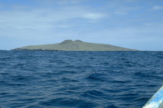 Isla San Martín, 6 km off the west coast of Baja California, is the westernmost volcano of the San Quintín volcanic field and the only one that is located offshore. The 2-km-wide island is a shield volcano capped by scoria cones that reach 230 m above sea level. Wave erosion has truncated part of the volcano, forming the sea cliffs seen at the left on the S side of the island.
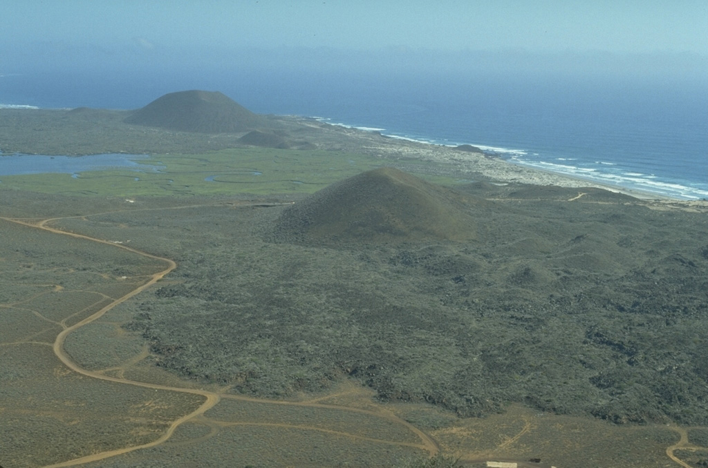
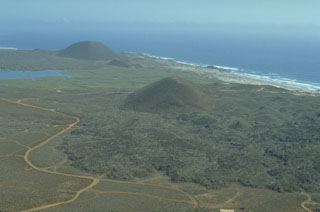 The San Quintín Volcanic Field on the NW coast of Baja California contains lava flows and young scoria cones. This view looks south from Volcán Basu to Picacho Vizcaino (surrounded by young lava flows), and Volcán Sudoeste (upper left). These are among the youngest features of the San Quintín field.
 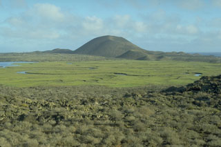 The Volcán Sudoeste scoria cone, and smaller cones at its base, are part of the San Quintín volcanic field in México's Baja Peninsula. They are seen here from the north on the slopes of Picacho Vizcaino. Volcán Sudoeste is one of the youngest scoria cones of the field.
 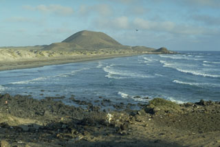 Volcán Sudoeste, one of a group of young cones of the San Quintín Volcanic Field, is located at the end of a narrow peninsula extending into the Pacific Ocean. The sand bars along the coast connect Volcán Sudoeste to Monte Mazo, at the southern end of a 10-km-long sand spit.
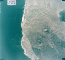 This 1978 aerial photo shows the nested craters of Volcán Riveroll (right-center) and the intersecting craters of Volcán Basu (below and to the left). The Riveroll craters open towards the NW (upper left). The darker basaltic lava flows extend to the SE from both cone complexes. The flow from Riveroll diverts around the Kenton scoria cone (edge of image at the lower right). The lighter areas are windblown sand. the Pacific coast shoreline is to the left, and the body of water to the upper right is part of San Quintín Bay.
 Volcán Riveroll, seen here from the NE, is the northernmost of the southern group of cones within the San Quintín Volcanic Field. A broad crater is at the summit and opens widely to the NW. A smaller nested crater was constructed within the original crater and is the youngest feature of the volcano.
 Volcán Ceniza (left) and Cerro Kenton (right), seen here from near Chapala, are two of a group of young scoria cones in the southern part of the San Quintín Volcanic Field in northern Baja California. Along with the Riveroll cone to the NW, they are constructed along a NW-SE trend, one of several fracture patterns in the San Quintín field. The two cones form a peninsula extending into Bahia Falsa, part of which is visible to the left.
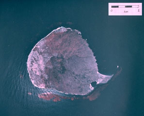 A vertical aerial photograph shows the small, roughly 1-km-wide Isla San Martín, the westernmost of the small volcanoes of the San Quintín volcanic field. Isla San Martín lies 6 km off the Pacific Ocean coast from the rest of the volcanic field and consists of a small basaltic shield volcano capped by a less than 40-m-high cinder cone. The peninsula at the SE (lower right) side of the island is formed by a lava flow.
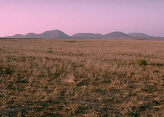 The Woodford group (Ieft) and Media Luna (right), seen here from the SSE, comprise the northern group of cones of the San Quintín Volcanic Field. It consists of a cluster of scoria cones and associated lava flows. The large cone of Media Luna opens towards the east, and it produced a lava flow in that direction.
The following 100 samples associated with this volcano can be found in the Smithsonian's NMNH Department of Mineral Sciences collections, and may be availble for research (contact the Rock and Ore Collections Manager). Catalog number links will open a window with more information.
| Catalog Number | Sample Description | Lava Source | Collection Date |
|---|---|---|---|
| NMNH 116600-1 | Alkalic Basalt | -- | -- |
| NMNH 116600-10 | Hawaiite | -- | -- |
| NMNH 116600-11 | Hawaiite | -- | -- |
| NMNH 116600-12 | Alkalic Basalt | -- | -- |
| NMNH 116600-13 | Basanite | -- | -- |
| NMNH 116600-14 | Alkalic Basalt | -- | -- |
| NMNH 116600-15 | Basanite | -- | -- |
| NMNH 116600-16 | Hawaiite | -- | -- |
| NMNH 116600-17 | Alkalic Basalt | -- | -- |
| NMNH 116600-18 | Alkalic Basalt | -- | -- |
| NMNH 116600-19 | Alkalic Basalt | -- | -- |
| NMNH 116600-2 | Alkalic Basalt | -- | -- |
| NMNH 116600-20 | Alkalic Basalt | -- | -- |
| NMNH 116600-21 | Alkalic Basalt | -- | -- |
| NMNH 116600-22 | Basanite | -- | -- |
| NMNH 116600-23 | Hawaiite | -- | -- |
| NMNH 116600-24 | Hawaiite | -- | -- |
| NMNH 116600-25 | Hawaiite | -- | -- |
| NMNH 116600-26 | Hawaiite | -- | -- |
| NMNH 116600-27 | Basanite | -- | -- |
| NMNH 116600-28 | Hawaiite | -- | -- |
| NMNH 116600-29 | Hawaiite | -- | -- |
| NMNH 116600-3 | Alkalic Basalt | -- | -- |
| NMNH 116600-30 | Basanite | -- | -- |
| NMNH 116600-31 | Alkalic Basalt | -- | -- |
| NMNH 116600-32 | Alkalic Basalt | -- | -- |
| NMNH 116600-33 | Alkalic Basalt | -- | -- |
| NMNH 116600-34 | Basanite | -- | -- |
| NMNH 116600-35 | Alkalic Basalt | -- | -- |
| NMNH 116600-36 | Alkalic Basalt | -- | -- |
| NMNH 116600-37 | Basalt | -- | -- |
| NMNH 116600-38 | Hawaiite | -- | -- |
| NMNH 116600-39 | Hawaiite | -- | -- |
| NMNH 116600-4 | Alkalic Basalt | -- | -- |
| NMNH 116600-40 | Hawaiite | -- | -- |
| NMNH 116600-41 | Hawaiite | -- | -- |
| NMNH 116600-42 | Hawaiite | -- | -- |
| NMNH 116600-43 | Hawaiite | -- | -- |
| NMNH 116600-44 | Hawaiite | -- | -- |
| NMNH 116600-45 | Hawaiite | -- | -- |
| NMNH 116600-46 | Hawaiite | -- | -- |
| NMNH 116600-47 | Hawaiite | -- | -- |
| NMNH 116600-48 | Hawaiite | -- | -- |
| NMNH 116600-49 | Hawaiite | -- | -- |
| NMNH 116600-5 | Basanite | -- | -- |
| NMNH 116600-50 | Basanite | -- | -- |
| NMNH 116600-51 | Hawaiite | -- | -- |
| NMNH 116600-52 | Basanite | -- | -- |
| NMNH 116600-53 | Basanite | -- | -- |
| NMNH 116600-54 | Basanite | -- | -- |
| NMNH 116600-55 | Hawaiite | -- | -- |
| NMNH 116600-56 | Alkalic Basalt | -- | -- |
| NMNH 116600-57 | Alkalic Basalt | -- | -- |
| NMNH 116600-58 | Alkalic Basalt | -- | -- |
| NMNH 116600-59 | Alkalic Basalt | -- | -- |
| NMNH 116600-6 | Basanite | -- | -- |
| NMNH 116600-60 | Basalt | -- | -- |
| NMNH 116600-61 | Hawaiite | -- | -- |
| NMNH 116600-62 | Alkalic Basalt | -- | -- |
| NMNH 116600-63 | Alkalic Basalt | -- | -- |
| NMNH 116600-64 | Unidentified | -- | -- |
| NMNH 116600-7 | Basanite | -- | -- |
| NMNH 116600-8 | Alkalic Basalt | -- | -- |
| NMNH 116600-9 | Hawaiite | -- | -- |
| NMNH 116610-24 | Lherzolite | MEDIA LUNA | -- |
| NMNH 116610-25 | Xenolith | MEDIA LUNA | -- |
| NMNH 116610-26 | Lherzolite | MEDIA LUNA | -- |
| NMNH 116610-27 | Lherzolite | MEDIA LUNA | -- |
| NMNH 116610-28 | Dunite | MEDIA LUNA | -- |
| NMNH 116610-29 | Xenolith | MEDIA LUNA | -- |
| NMNH 116610-3 | Spinel Peridotite | -- | -- |
| NMNH 116857-14 | Spinel Lherzolite | -- | -- |
| NMNH 117213-38 | Clinopyroxene | -- | -- |
| NMNH 117214-40 | Xenolith | MEDIA LUNA | -- |
| NMNH 117214-42 | Xenolith | MEDIA LUNA | -- |
| NMNH 117214-43 | Xenolith | MEDIA LUNA | -- |
| NMNH 117214-44 | Xenolith | MEDIA LUNA | -- |
| NMNH 117214-45 | Xenolith | MEDIA LUNA | -- |
| NMNH 117214-46 | Xenolith | MEDIA LUNA | -- |
| NMNH 117214-47 | Xenolith | MEDIA LUNA | -- |
| NMNH 117214-48 | Xenolith | -- | -- |
| NMNH 117588-1 | Basalt | Volcán Basu | -- |
| NMNH 117588-15 | Basalt | Cerro Kenton | -- |
| NMNH 117588-16 | Basalt | Cerro Kenton | -- |
| NMNH 117588-17 | Scoria | Volcán Bacon | -- |
| NMNH 117588-18 | Basalt | -- | -- |
| NMNH 117588-19 | Sand | -- | -- |
| NMNH 117588-2 | Basalt | Volcán Basu | -- |
| NMNH 117588-20 | Sand | -- | -- |
| NMNH 117588-21 | Scoria | -- | -- |
| NMNH 117588-22 | Basalt | -- | -- |
| NMNH 117588-23 | Basalt | -- | -- |
| NMNH 117588-3 | Basalt | Picacho Vizcaino | -- |
| NMNH 117588-4 | Basalt | Picacho Vizcaino | -- |
| NMNH 117588-5 | Plagioclase | -- | -- |
| NMNH 117588-6 | Clinopyroxene | -- | -- |
| NMNH 117633-1 | Basalt | -- | -- |
| NMNH 117633-2 | Basalt | -- | -- |
| NMNH 117633-3 | Basalt | -- | -- |
| NMNH 117633-4 | Basalt | -- | -- |
| Copernicus Browser | The Copernicus Browser replaced the Sentinel Hub Playground browser in 2023, to provide access to Earth observation archives from the Copernicus Data Space Ecosystem, the main distribution platform for data from the EU Copernicus missions. |
|
WOVOdat
Single Volcano View Temporal Evolution of Unrest Side by Side Volcanoes |
WOVOdat is a database of volcanic unrest; instrumentally and visually recorded changes in seismicity, ground deformation, gas emission, and other parameters from their normal baselines. It is sponsored by the World Organization of Volcano Observatories (WOVO) and presently hosted at the Earth Observatory of Singapore.
GVMID Data on Volcano Monitoring Infrastructure The Global Volcano Monitoring Infrastructure Database GVMID, is aimed at documenting and improving capabilities of volcano monitoring from the ground and space. GVMID should provide a snapshot and baseline view of the techniques and instrumentation that are in place at various volcanoes, which can be use by volcano observatories as reference to setup new monitoring system or improving networks at a specific volcano. These data will allow identification of what monitoring gaps exist, which can be then targeted by remote sensing infrastructure and future instrument deployments. |
| IRIS seismic stations/networks | Incorporated Research Institutions for Seismology (IRIS) Data Services map showing the location of seismic stations from all available networks (permanent or temporary) within a radius of 0.18° (about 20 km at mid-latitudes) from the given location of San Quintín Volcanic Field. Users can customize a variety of filters and options in the left panel. Note that if there are no stations are known the map will default to show the entire world with a "No data matched request" error notice. |
| UNAVCO GPS/GNSS stations | Geodetic Data Services map from UNAVCO showing the location of GPS/GNSS stations from all available networks (permanent or temporary) within a radius of 20 km from the given location of San Quintín Volcanic Field. Users can customize the data search based on station or network names, location, and time window. Requires Adobe Flash Player. |
| Large Eruptions of San Quintín Volcanic Field | Information about large Quaternary eruptions (VEI >= 4) is cataloged in the Large Magnitude Explosive Volcanic Eruptions (LaMEVE) database of the Volcano Global Risk Identification and Analysis Project (VOGRIPA). |
| EarthChem | EarthChem develops and maintains databases, software, and services that support the preservation, discovery, access and analysis of geochemical data, and facilitate their integration with the broad array of other available earth science parameters. EarthChem is operated by a joint team of disciplinary scientists, data scientists, data managers and information technology developers who are part of the NSF-funded data facility Integrated Earth Data Applications (IEDA). IEDA is a collaborative effort of EarthChem and the Marine Geoscience Data System (MGDS). |

