The Global Volcanism Program has no activity reports available for Cofre de Perote.
The Global Volcanism Program has no Weekly Reports available for Cofre de Perote.
The Global Volcanism Program has no Bulletin Reports available for Cofre de Perote.
|
|
||||||||||||||||||||||||||||
There is data available for 1 confirmed Holocene eruptive periods.
1150 ± 100 years Confirmed Eruption (Explosive / Effusive) VEI: 2
| Episode 1 | Eruption (Explosive / Effusive) | Lower NE flank (El Volcancillo) | |||||||||||||||||||||||||||||||||||||||
|---|---|---|---|---|---|---|---|---|---|---|---|---|---|---|---|---|---|---|---|---|---|---|---|---|---|---|---|---|---|---|---|---|---|---|---|---|---|---|---|---|
| 1150 ± 100 years - Unknown | Evidence from Isotopic: 14C (calibrated) | |||||||||||||||||||||||||||||||||||||||
|
List of 6 Events for Episode 1 at Lower NE flank (El Volcancillo)
|
||||||||||||||||||||||||||||||||||||||||
This compilation of synonyms and subsidiary features may not be comprehensive. Features are organized into four major categories: Cones, Craters, Domes, and Thermal Features. Synonyms of features appear indented below the primary name. In some cases additional feature type, elevation, or location details are provided.
Synonyms |
||||
| Nauhcampta-tépetl | Naucampatépetl | Nappatecuhtlan | ||||
Cones |
||||
| Feature Name | Feature Type | Elevation | Latitude | Longitude |
| Central Cone Group | Pyroclastic cone | 2340 m | 19° 37' 30.00" N | 97° 2' 0.00" W |
| Colorado, Cerro | Pyroclastic cone | 2800 m | 19° 36' 0.00" N | 97° 7' 0.00" W |
| Joya, La | Pyroclastic cone | 2300 m | 19° 36' 30.00" N | 97° 1' 0.00" W |
| Lajas, Cerro las | Shield volcano | 3140 m | 19° 35' 30.00" N | 97° 6' 0.00" W |
| Volcancillo, El | Pyroclastic cone | 2700 m | 19° 37' 0.00" N | 97° 5' 0.00" W |
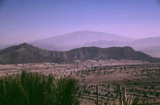 The broad Cofre de Perote massif towers above the eastern margin of the Serdán-Oriental basin. The low-angle volcano consists primarily of thick lava flows. It is the northernmost volcano of a roughly N-S-trending chain at the eastern margin of the Mexican Volcanic Belt that extends southward to Orizaba volcano. The ridge in the center of the photo is an outcrop of Cretaceous limestone that underlies the Cofre-Orizaba volcanic chain and is exposed on either side of the range.
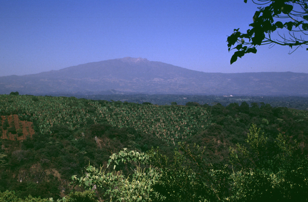
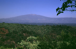 Cofre de Perote, a massive Quaternary volcano at the NNE end of a volcanic chain extending southward to Pico de Orizaba volcano, rises above banana crops below its SE flank. A large compound escarpment formed in part by edifice collapse is visible on the eastern flank. The upper part of this scarp forms the barren area below the summit. Numerous scoria cones, some of Holocene age, formed across the flanks of the largely Pleistocene edifice.
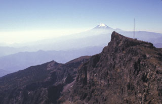 The eastern side of the summit of Cofre de Perote contains a steep escarpment. The volcano lies at the NNE end of a N-S-trending range that extends 50 km S to glaciated, historically active Pico de Orizaba (Citlaltépetl) in the distance. Like other N-S volcanic chains in México perpendicular to the Mexican Volcanic Belt, volcanism in the Cofre-Orizaba chain has migrated to the south.
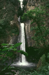 A series of waterfalls near the town of Xico on the eastern flank of Cofre de Perote formed over a massive lava flow. Cofre de Perote was constructed along the margin of the Mexican Altiplano, and thick viscous Pleistocene lava flows extend tens of kilometers down the eastern flanks towards the coastal plain.
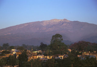 Large compound horseshoe-shaped scarps, formed in part by edifice collapse, are visible near the summit of the eastern side of Cofre de Perote volcano. The massive size of the edifice can be appreciated in this photo taken from the city of Coatepec, which lies 21 km ESE and 3,000 m below the summit.
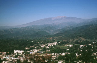 Cofre de Perote volcano towers above the city of Coatepec on its eastern flank. The flanks of contain smaller cones, including the one in the center of the city from which this photo was taken. The volcano was constructed at the eastern margin of the Altiplano and consequently has an asymmetrical profile, extending farther towards the east in the direction of the lower-altitude coastal plain.
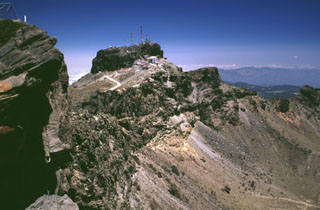 The summit region of Cofre de Perote consists of at least two glacially eroded edifices. Glacial cirques and moraines are found in the summit area. The steep-walled east-facing scarp cutting across the center of the photo that exposes westward-dipping lavas was formed in part by edifice collapse.
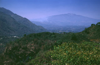 The broad Cofre de Perote massif to the upper right is at the northern end of a N-S-trending volcanic chain at the far eastern side of the Mexican Volcanic Belt. The broad profile was produced by the extrusion of thick sequences of lava flows.
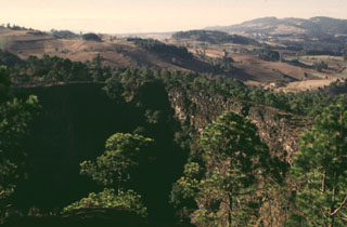 The steep-walled 200-m-wide crater in the foreground at El Volcancillo on the NE flank of Cofre de Perote was the source of the voluminous Río Naolinco lava flow about 900 years ago. The pahoehoe lava flow traveled initially to the north and then to the east for a distance of 50 km, partly within lava tubes. El Volcancillo consists of two overlapping craters constructed on a ridge crest. The Río Naolinco lava flow originated from the NW crater; the SE crater fed the Toxtlacuaya ‘a’a lava flow down a valley on the opposite side of the ridge.
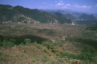 The people in the left foreground are standing on the Toxtlacuaya lava flow, which traveled in a narrow lobe down into the valley filled by the flat-lying Río Naolinco lava flow. Both flows were produced about 900 years ago during a geochemically bimodal eruption which initially produced the alkaline Toxtlacuaya lava flow and then the voluminous calc-alkaline Río Naolinco flow. Although the flows erupted through the lower flanks of Cofre de Perote volcano, they are geochemically distinct from Cofre de Perote lavas.
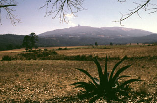 Cofre de Perote, sometimes referred to as the Treasure Chest of Perote, is seen here from the NW above fields near the town of Perote. The lower northern flanks of the largely Pleistocene volcano are overlain by ignimbrite deposits that erupted from the Los Húmeros caldera.
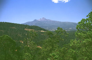 One of the Aztec names for Cofre de Perote was Naucampatepetl, or "Mountain of Four Sides." The flat-topped glacially modified summit is seen here from the NE on the road between the cities of Perote and Jalapa (Xalapa), the capital city of the state of Veracruz. The highway follows the low-angle surface of valley floors filled by young lava flows that erupted from vents on the NE flank.
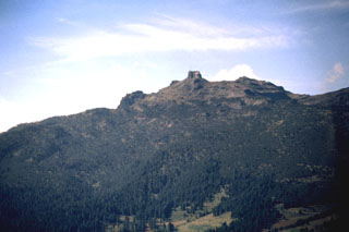 The smooth profile of the Cofre de Perote volcano is modified on the NE side by steep escarpments. The morphology of the summit reflects both edifice collapse and glacial erosion. Dacite lava flows can be seen on the right-hand horizon.
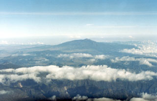 The broad Cofre de Perote massif in the distance is seen in an aerial view from the west. As with other volcanoes of the Orizaba-Cofre chain, it was constructed over the eastern margin of the Mexican altiplano, so that the volcano asymmetrically extends farther toward the lower-elevation coastal plain. It rises 1,700 m above the Serdán-Oriental basin on the west and 3,000 m above the city of Jalapa (Xalapa) to the east.
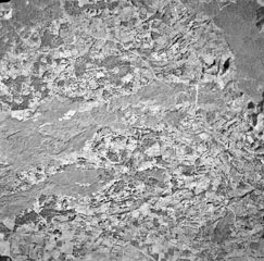 Quaternary lava flows of varying ages cover the entire 4-km-wide field of view in this aerial photo of an area NW of Jalapa. Several lobes of the sparsely vegetated Toxtlacuaya lava flow extend across the center of the photo. The northernmost lobe joins with the darker-colored Río Naolinco lava flow at the upper right. Both of these flows were erupted about 900 years ago from El Volcancillo, a vent on the NE flank of Cofre de Perote. The Toxtlacuaya flow overlies older flows from the Central Cone Complex and still older flows at the bottom from Cerro La Joya.
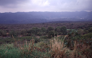 The Río Naolinco lava flow, which fills the entire valley floor in the foreground, is the most voluminous of two chemically distinct lava flows erupted from El Volcancillo on the south flank of Cofre de Perote volcano about 900 years ago. The Río Naolinco flow traveled 50 km and has an estimated volume of about 1.3 km3. This view looks south across the flow near its widest point about 25 km from the vent.
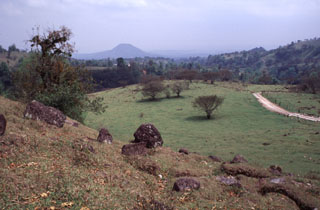 The slope in the foreground is the surface of the Xico debris avalanche deposit, which formed at the end of the Pleistocene during the youngest of several edifice collapse events at Cofre de Perote volcano. The highly mobile avalanche traveled into the Río Pescado drainage and covers an area of at least area ∼73 km2.
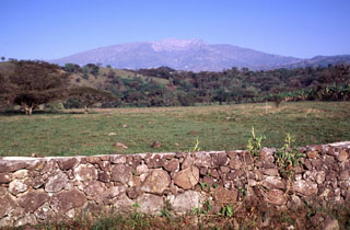 The eastern side of Cofre de Perote volcano contains scarps from a series of edifice collapse events during the late Pleistocene. The youngest escarpment forms the unvegetated area below the summit in this view from just south of the town of Xico, which overlies the youngest avalanche deposit. The summit of Cofre lies 17 km to the west and 3,000 m above this location.
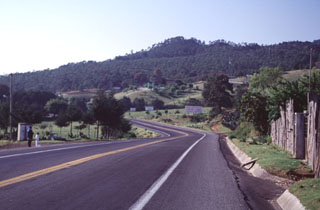 The hill on the horizon is El Volcanicillo, a scoria cone that produced two lava flows down opposite sides of a ridge on the NE flank of Cofre de Perote volcano. The forested area extending across the photo below the cone is the Río Naolinco lava flow, a massive 900-year-old pahoehoe flow that reached as far as 50 km from El Volcanillo; the ‘a’a Toxtlacuaya flow traveled down the opposite side of the ridge. Highway 140 is in the foreground.
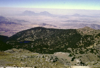 Glacial erosion has modified the summit of Cofre de Perote volcano. Summit lava flows show glacial striations, and a glacial tarn (left) is SW of the summit. Cofre de Perote overlooks the intermontaine Serdán-Oriental basin, which contains lava domes, tuff rings, lava flows, and scoria cones. The two Las Derrumbadas lava domes are in the distance and Cerro Pinto dome to their right are about 40 km SW.
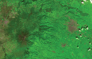 The flanks of the massive Cofre de Perote shield volcano extend across most of the left two-thirds of this satellite image. The summit of the volcano (lower left) has been truncated by edifice failure to the east. The large brown area at the middle right is Jalapa, the capital city of the state of Veracruz; to its SW is the city of Coatepeque. The voluminous dark-colored Río Naolinco lava flow north of Jalapa originated from a vent on the lower NE flank of Cofre de Perote about 900 years ago and traveled an additional 15 km beyond the margin of this image.
There are no samples for Cofre de Perote in the Smithsonian's NMNH Department of Mineral Sciences Rock and Ore collection.
| Copernicus Browser | The Copernicus Browser replaced the Sentinel Hub Playground browser in 2023, to provide access to Earth observation archives from the Copernicus Data Space Ecosystem, the main distribution platform for data from the EU Copernicus missions. |
| MIROVA | Middle InfraRed Observation of Volcanic Activity (MIROVA) is a near real time volcanic hot-spot detection system based on the analysis of MODIS (Moderate Resolution Imaging Spectroradiometer) data. In particular, MIROVA uses the Middle InfraRed Radiation (MIR), measured over target volcanoes, in order to detect, locate and measure the heat radiation sourced from volcanic activity. |
| MODVOLC Thermal Alerts | Using infrared satellite Moderate Resolution Imaging Spectroradiometer (MODIS) data, scientists at the Hawai'i Institute of Geophysics and Planetology, University of Hawai'i, developed an automated system called MODVOLC to map thermal hot-spots in near real time. For each MODIS image, the algorithm automatically scans each 1 km pixel within it to check for high-temperature hot-spots. When one is found the date, time, location, and intensity are recorded. MODIS looks at every square km of the Earth every 48 hours, once during the day and once during the night, and the presence of two MODIS sensors in space allows at least four hot-spot observations every two days. Each day updated global maps are compiled to display the locations of all hot spots detected in the previous 24 hours. There is a drop-down list with volcano names which allow users to 'zoom-in' and examine the distribution of hot-spots at a variety of spatial scales. |
|
WOVOdat
Single Volcano View Temporal Evolution of Unrest Side by Side Volcanoes |
WOVOdat is a database of volcanic unrest; instrumentally and visually recorded changes in seismicity, ground deformation, gas emission, and other parameters from their normal baselines. It is sponsored by the World Organization of Volcano Observatories (WOVO) and presently hosted at the Earth Observatory of Singapore.
GVMID Data on Volcano Monitoring Infrastructure The Global Volcano Monitoring Infrastructure Database GVMID, is aimed at documenting and improving capabilities of volcano monitoring from the ground and space. GVMID should provide a snapshot and baseline view of the techniques and instrumentation that are in place at various volcanoes, which can be use by volcano observatories as reference to setup new monitoring system or improving networks at a specific volcano. These data will allow identification of what monitoring gaps exist, which can be then targeted by remote sensing infrastructure and future instrument deployments. |
| Volcanic Hazard Maps | The IAVCEI Commission on Volcanic Hazards and Risk has a Volcanic Hazard Maps database designed to serve as a resource for hazard mappers (or other interested parties) to explore how common issues in hazard map development have been addressed at different volcanoes, in different countries, for different hazards, and for different intended audiences. In addition to the comprehensive, searchable Volcanic Hazard Maps Database, this website contains information about diversity of volcanic hazard maps, illustrated using examples from the database. This site is for educational purposes related to volcanic hazard maps. Hazard maps found on this website should not be used for emergency purposes. For the most recent, official hazard map for a particular volcano, please seek out the proper institutional authorities on the matter. |
| IRIS seismic stations/networks | Incorporated Research Institutions for Seismology (IRIS) Data Services map showing the location of seismic stations from all available networks (permanent or temporary) within a radius of 0.18° (about 20 km at mid-latitudes) from the given location of Cofre de Perote. Users can customize a variety of filters and options in the left panel. Note that if there are no stations are known the map will default to show the entire world with a "No data matched request" error notice. |
| UNAVCO GPS/GNSS stations | Geodetic Data Services map from UNAVCO showing the location of GPS/GNSS stations from all available networks (permanent or temporary) within a radius of 20 km from the given location of Cofre de Perote. Users can customize the data search based on station or network names, location, and time window. Requires Adobe Flash Player. |
| DECADE Data | The DECADE portal, still in the developmental stage, serves as an example of the proposed interoperability between The Smithsonian Institution's Global Volcanism Program, the Mapping Gas Emissions (MaGa) Database, and the EarthChem Geochemical Portal. The Deep Earth Carbon Degassing (DECADE) initiative seeks to use new and established technologies to determine accurate global fluxes of volcanic CO2 to the atmosphere, but installing CO2 monitoring networks on 20 of the world's 150 most actively degassing volcanoes. The group uses related laboratory-based studies (direct gas sampling and analysis, melt inclusions) to provide new data for direct degassing of deep earth carbon to the atmosphere. |
| Large Eruptions of Cofre de Perote | Information about large Quaternary eruptions (VEI >= 4) is cataloged in the Large Magnitude Explosive Volcanic Eruptions (LaMEVE) database of the Volcano Global Risk Identification and Analysis Project (VOGRIPA). |
| EarthChem | EarthChem develops and maintains databases, software, and services that support the preservation, discovery, access and analysis of geochemical data, and facilitate their integration with the broad array of other available earth science parameters. EarthChem is operated by a joint team of disciplinary scientists, data scientists, data managers and information technology developers who are part of the NSF-funded data facility Integrated Earth Data Applications (IEDA). IEDA is a collaborative effort of EarthChem and the Marine Geoscience Data System (MGDS). |

