The Global Volcanism Program has no activity reports available for San Juan.
The Global Volcanism Program has no Weekly Reports available for San Juan.
The Global Volcanism Program has no Bulletin Reports available for San Juan.
|
|
||||||||||||||||||
The Global Volcanism Program is not aware of any Holocene eruptions from San Juan. If this volcano has had large eruptions (VEI >= 4) prior to 12,000 years ago, information might be found on the San Juan page in the LaMEVE (Large Magnitude Explosive Volcanic Eruptions) database, a part of the Volcano Global Risk Identification and Analysis Project (VOGRIPA).
This compilation of synonyms and subsidiary features may not be comprehensive. Features are organized into four major categories: Cones, Craters, Domes, and Thermal Features. Synonyms of features appear indented below the primary name. In some cases additional feature type, elevation, or location details are provided.
Cones |
||||
| Feature Name | Feature Type | Elevation | Latitude | Longitude |
| Alto, Cerro | Stratovolcano | 2240 m | 21° 27' 0.00" N | 104° 58' 30.00" W |
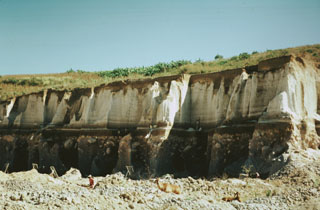 The locally widespread Tepic Pumice is exposed in this quarry on the NW outskirts of the city of Tepic. The zoned rhyodacitic-andesitic pumice, forming the upper half of this exposure, was erupted about 15,000 years ago and resulted in the formation of a 4-km-wide caldera at the summit of San Juan volcano. The 5.6 cu km Tepic Pumice deposit underlies the city of Tepic, the captial city of Narayit state, to thickness of 2-9 m.
 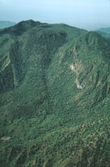 Following the eruption of the Tepic Pumice and the formation of an elongated caldera at the summit of San Juan volcano, a lava dome was constructed within the caldera. The dome forms the rounded forested area in front of the western caldera rim, which marks the horizon. The caldera is 4 km wide in the E-W direction of this photo and 1 km wide in a N-S direction. Andesitic lava flows (left center) erupted from the dome and flowed across the caldera floor to its eastern side.
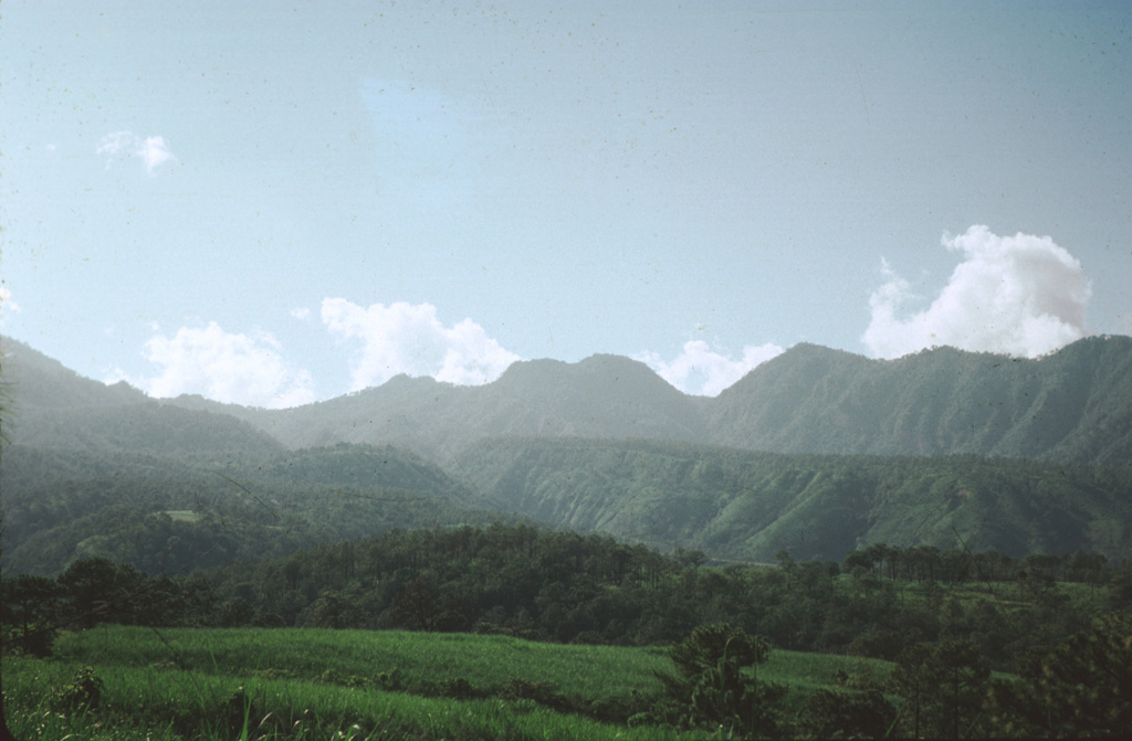
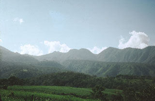 Volcán San Juan, the NW-most major volcano of the Mexican Volcanic Belt, displays an irregular profile west of the city of Tepic. The northern wall of a 1 x 4 km wide, oval-shaped caldera that was created about 15,000 years ago forms the right-hand horizon. The rounded notched peak on the center horizon is an intracaldera lava dome that was constructed shortly thereafter. The flanks of Cerro Alto stratovolcano, the 2240 m high point of the San Juan volcanic complex, can be seen at the extreme left.
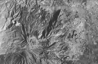 A composite aerial photo with north to the top shows the lighter-gray summit of San Juan volcano just left of the center of the photo. Cerro Alto, the highest peak of the San Juan complex, forms the dark area at the lower left. A dark shadow highlights a 5-km-long NE-trending ridge that marks an eruptive fissure of the cone-building stage of San Juan. Prominent leveed lava flows that reach the northern flank mark the latest eruptive products of San Juan. The cities of Tepic and Jalisco lie at the upper and lower right, respectively.
There are no samples for San Juan in the Smithsonian's NMNH Department of Mineral Sciences Rock and Ore collection.
| Copernicus Browser | The Copernicus Browser replaced the Sentinel Hub Playground browser in 2023, to provide access to Earth observation archives from the Copernicus Data Space Ecosystem, the main distribution platform for data from the EU Copernicus missions. |
|
WOVOdat
Single Volcano View Temporal Evolution of Unrest Side by Side Volcanoes |
WOVOdat is a database of volcanic unrest; instrumentally and visually recorded changes in seismicity, ground deformation, gas emission, and other parameters from their normal baselines. It is sponsored by the World Organization of Volcano Observatories (WOVO) and presently hosted at the Earth Observatory of Singapore.
GVMID Data on Volcano Monitoring Infrastructure The Global Volcano Monitoring Infrastructure Database GVMID, is aimed at documenting and improving capabilities of volcano monitoring from the ground and space. GVMID should provide a snapshot and baseline view of the techniques and instrumentation that are in place at various volcanoes, which can be use by volcano observatories as reference to setup new monitoring system or improving networks at a specific volcano. These data will allow identification of what monitoring gaps exist, which can be then targeted by remote sensing infrastructure and future instrument deployments. |
| IRIS seismic stations/networks | Incorporated Research Institutions for Seismology (IRIS) Data Services map showing the location of seismic stations from all available networks (permanent or temporary) within a radius of 0.18° (about 20 km at mid-latitudes) from the given location of San Juan. Users can customize a variety of filters and options in the left panel. Note that if there are no stations are known the map will default to show the entire world with a "No data matched request" error notice. |
| UNAVCO GPS/GNSS stations | Geodetic Data Services map from UNAVCO showing the location of GPS/GNSS stations from all available networks (permanent or temporary) within a radius of 20 km from the given location of San Juan. Users can customize the data search based on station or network names, location, and time window. Requires Adobe Flash Player. |
| Large Eruptions of San Juan | Information about large Quaternary eruptions (VEI >= 4) is cataloged in the Large Magnitude Explosive Volcanic Eruptions (LaMEVE) database of the Volcano Global Risk Identification and Analysis Project (VOGRIPA). |
| EarthChem | EarthChem develops and maintains databases, software, and services that support the preservation, discovery, access and analysis of geochemical data, and facilitate their integration with the broad array of other available earth science parameters. EarthChem is operated by a joint team of disciplinary scientists, data scientists, data managers and information technology developers who are part of the NSF-funded data facility Integrated Earth Data Applications (IEDA). IEDA is a collaborative effort of EarthChem and the Marine Geoscience Data System (MGDS). |

