
The Global Volcanism Program has no activity reports available for Santo Tomás-Zunil.
The Global Volcanism Program has no Weekly Reports available for Santo Tomás-Zunil.
The Global Volcanism Program has no Bulletin Reports available for Santo Tomás-Zunil.
|
|
||||||||||||||||||
The Global Volcanism Program is not aware of any Holocene eruptions from Santo Tomás-Zunil. If this volcano has had large eruptions (VEI >= 4) prior to 12,000 years ago, information might be found on the Santo Tomás-Zunil page in the LaMEVE (Large Magnitude Explosive Volcanic Eruptions) database, a part of the Volcano Global Risk Identification and Analysis Project (VOGRIPA).
This compilation of synonyms and subsidiary features may not be comprehensive. Features are organized into four major categories: Cones, Craters, Domes, and Thermal Features. Synonyms of features appear indented below the primary name. In some cases additional feature type, elevation, or location details are provided.
Synonyms |
||||
| Pecul, Volcán | ||||
Craters |
||||
| Feature Name | Feature Type | Elevation | Latitude | Longitude |
| Tzanjuyub | Pleistocene caldera | 3542 m | 14° 46' 0.00" N | 91° 26' 0.00" W |
Domes |
||||
| Feature Name | Feature Type | Elevation | Latitude | Longitude |
| Chiucham, Cerro | Dome | 3278 m | 14° 47' 2.00" N | 91° 26' 6.00" W |
| Chonajtajuyub, Cerro | Dome | 2947 m | 14° 46' 59.00" N | 91° 26' 46.00" W |
| Jolom, Cerro | Dome | 2890 m | 14° 47' 49.00" N | 91° 26' 6.00" W |
| Zunil | Dome | 3542 m | 14° 44' 20.00" N | 91° 27' 0.00" W |
Thermal |
||||
| Feature Name | Feature Type | Elevation | Latitude | Longitude |
| Aguas Amargas | Thermal | |||
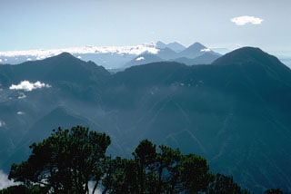 Volcán Santo Tomás is a Pleistocene stratovolcano, seen here from the summit of Santa María volcano to its NW. Geothermal activity occurs 3 km N and NW of the Volcán Zunil summit (right), which is located at the southern end of the volcanic complex. The Tolimán-Atitlán and Acatenango-Fuego complexes appear in the distance.
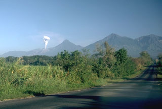 A plume rises from a Santiaguito lava dome on the flank of Santa María. Volcán Santo Tomás is the peak further to the right. A winding ridge connects Santo Tomás to Volcán de Zunil, 4.5 km to the NE, the peak at the far right.
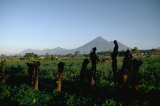 Volcán Atitlán rises above the Pacific coastal plain of Guatemala. Tolimán is the lower peak to the right of the summit. The volcanic highlands of Guatemala are seen here from the SE with Volcán Santo Tomás on the far left, 35 km to the NW of Atitlán.
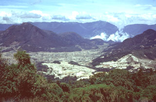 The Cerro Quemado lava dome (left), seen here from Siete Orejas volcano, is one of a series of lava domes along the margin of the Almolonga caldera. The Cerro Quemado dome complex formed during the Holocene from eruptions along at least eight vents. One of these domes forms the low rounded feature below the center horizon. Santa María lies just out of view to the right, and the western side of the Santo Tomás volcanic complex forms the horizon.
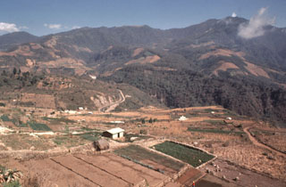 Volcán Santo Tomás is a large eroded stratovolcano seen here to the east across the valley of the Río Samalá from the Zunil geothermal site. The summit of Volcán de Zunil is 4.5 km to the NE. Geothermal fields are located on the NW Santo Tomás flank and 3 km north along the ridge to the Zunil summit.
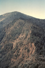 This view looks to the south from near the summit of Volcán de Zunil towards Volcán Santo Tomás. Geothermal fields are located along the ridge between Santo Tomás and Zunil.
 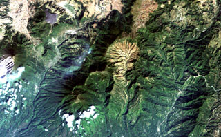 The light-colored, furrowed area at the top-center is the 4-km-wide, 600-m-deep Tzanjuyub caldera, which is breached to the south by the Río Masa. At the SW side of the Pleistocene caldera is Volcán Zunil, which is connected by an irregular ridge to Volcán Santo Tomás, a large eroded stratovolcano above the clouds at the bottom of the image. Santa María volcano (far left-center) lies across the Río Samalá to the east. Solfataras and thermal springs are located on the west side of the ridge between Santo Tomás and Zunil.
There are no samples for Santo Tomás-Zunil in the Smithsonian's NMNH Department of Mineral Sciences Rock and Ore collection.
| Copernicus Browser | The Copernicus Browser replaced the Sentinel Hub Playground browser in 2023, to provide access to Earth observation archives from the Copernicus Data Space Ecosystem, the main distribution platform for data from the EU Copernicus missions. |
|
WOVOdat
Single Volcano View Temporal Evolution of Unrest Side by Side Volcanoes |
WOVOdat is a database of volcanic unrest; instrumentally and visually recorded changes in seismicity, ground deformation, gas emission, and other parameters from their normal baselines. It is sponsored by the World Organization of Volcano Observatories (WOVO) and presently hosted at the Earth Observatory of Singapore.
GVMID Data on Volcano Monitoring Infrastructure The Global Volcano Monitoring Infrastructure Database GVMID, is aimed at documenting and improving capabilities of volcano monitoring from the ground and space. GVMID should provide a snapshot and baseline view of the techniques and instrumentation that are in place at various volcanoes, which can be use by volcano observatories as reference to setup new monitoring system or improving networks at a specific volcano. These data will allow identification of what monitoring gaps exist, which can be then targeted by remote sensing infrastructure and future instrument deployments. |
| IRIS seismic stations/networks | Incorporated Research Institutions for Seismology (IRIS) Data Services map showing the location of seismic stations from all available networks (permanent or temporary) within a radius of 0.18° (about 20 km at mid-latitudes) from the given location of Santo Tomás-Zunil. Users can customize a variety of filters and options in the left panel. Note that if there are no stations are known the map will default to show the entire world with a "No data matched request" error notice. |
| UNAVCO GPS/GNSS stations | Geodetic Data Services map from UNAVCO showing the location of GPS/GNSS stations from all available networks (permanent or temporary) within a radius of 20 km from the given location of Santo Tomás-Zunil. Users can customize the data search based on station or network names, location, and time window. Requires Adobe Flash Player. |
| Large Eruptions of Santo Tomás-Zunil | Information about large Quaternary eruptions (VEI >= 4) is cataloged in the Large Magnitude Explosive Volcanic Eruptions (LaMEVE) database of the Volcano Global Risk Identification and Analysis Project (VOGRIPA). |
| EarthChem | EarthChem develops and maintains databases, software, and services that support the preservation, discovery, access and analysis of geochemical data, and facilitate their integration with the broad array of other available earth science parameters. EarthChem is operated by a joint team of disciplinary scientists, data scientists, data managers and information technology developers who are part of the NSF-funded data facility Integrated Earth Data Applications (IEDA). IEDA is a collaborative effort of EarthChem and the Marine Geoscience Data System (MGDS). |

