Earthquake swarm in September 2002
In September 2002 an earthquake swarm was registered near Cosigüina. This swarm was the first to be recognized at that volcano in the 27 years of the existence of Nicaragua's seismic network. The historical seismic record contains no evidence of the type of cluster that occurred in September 2002, although there was seismic activity in 1951 that could have been of local origin (see below).
The seismicity began on 4 September, with M 2.4-3.6 events. The main earthquake occurred on 9 September with a magnitude of 3.9. The last event occurred on 16 September with a magnitude of 3.7. A total of 34 earthquakes occurred to the N of Cosigüina volcano. Unfortunately, the seismic station at the volcano failed to function due to radio signal transmission problems. Seismic readings were also obtained from the National System of Territorial Studies of El Salvador (SNET) for 31 earthquakes. Epicenters of the earthquakes, located with the readings obtained by the seismic networks of the Instituto Nicaragüense de Estudios Territoriales (INETER) and SNET, were concentrated in a zone approximately 4-5 km N and W of the crater (figure 1). The distribution, along a SW-NE axis, might be simply a product of the geometry of the configuration of seismic stations with which the events were located.
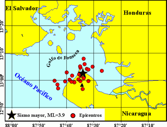 |
Figure 1. Epicentral map of the earthquakes located N of Cosigüina volcano. September 2002. Black triangle indicates approximate summit location. Courtesy of INETER. |
Randy White (USGS) indicated to INETER that the seismicity seems to have been of the volcano-tectonic type, caused by an intrusion of magma, based on several observations: 1) the two stages of the cluster on 4-6 and 9 September showed a release of similar seismic energy; 2) In the two stages there were many similarly sized events; 17 with a magnitude of 3.0 or less, but none greater than 3.9; 3) The maximum magnitude increased several times; and 4) The distribution of energy was highly unusual for tectonic seismicity. Apparently there were several groups of one or a few events in intervals of 5-7 hours. Regular pulsations are typical for volcanic earthquake swarms that last more than several hours.
INETER volcanologist Pedro Perez investigated the volcano on 12 September, but saw nothing anomalous. He also conducted interviews with local residents, went to the summit crater, and took measurements of thermal waters at the foot of the volcano. Within the crater walls, landslides were observed in the E, S, and W portions. Residents in the Marañonal, Potosí, Punta Ñata, and Apascali sectors did not feel the earthquakes.
Seismicity in August 1951. The following description is based on news reports compiled by INETER (The News, 1951 Ago. 07; The Press, 1951 Ago. 04, 05, 07, 09, 18).
In August 1951 there was strong seismic activity in western Nicaragua and southwestern Honduras. On 2 August one of a series of strong events produced a 200-m-long crack near Cosigüina that spewed large amounts of water, flooding the region. The seismic shocks also demolished three houses in Chinandega. These earthquakes were felt more strongly to the W and diminished to the N and in the direction of Managua. The population in these areas slept outside their homes for many days. The people of these sectors, mainly the western population, felt continuous and violent seismic shocks until 8 August. On 17 August a strong tremor shook the western region and Managua. Apparently, this seismic activity produced more than 100 events, not all of which were felt by all residents.
Information Contacts: Virginia Tenorio and Wilfried Strauch, Instituto Nicaragüense de Estudios Territoriales (INETER), Apartado 1761, Managua, Nicaragua (URL: http://www.ineter.gob.ni/).
The Global Volcanism Program has no Weekly Reports available for Cosigüina.
Reports are organized chronologically and indexed below by Month/Year (Publication Volume:Number), and include a one-line summary. Click on the index link or scroll down to read the reports.
No fumarolic activity visible
No fumarolic activity was visible from the rim [during a visit between mid-November. and early December.]
Information Contacts: R. Stoiber, S. Williams, H.R. Naslund, L. Malinconico, M. Conrad, Dartmouth College; S. Bonis, IGN, Guatemala; A. Aburto, D. Fajardo, Instituto de Investigaciones Sísmicas.
Temperature and pH measurements of the fresh crater lake
A team from the Université de Montréal, Open University, and INETER visited Cosigüina volcano on 25 February 1999. The summit crater contains a roughly circular lake with a dark green color. The lake has a maximum diameter of ~1.5 km and occupies about 90% of the crater bottom, the remaining area being covered with dense vegetation. The surface temperature of the lake measured from the NW shore with a thermocouple was ~27°C, slightly lower than the ambient air temperature (~31°C) measured at noon. The pH of the lake surface water measured directly with a glass electrode was slightly alkaline (pH ~7.5). Feeble, diffuse gas was bubbling at the surface of the lake along the NW shore. Temperature of the ground in these areas reached a maximum of ~80°C. There was no sign of recent hot spring or fumarolic activity in the crater. One spring located on the E flank of the volcano near the village of Potosi had a temperature of ~42°C, a flow rate of ~2 l/s and a total dissolved solids content 100 mg/kg. Apparently, it is the only permanent, visible hydrothermal manifestation near the volcano.
Information Contacts: Pierre Delmelle, Département de Géologie, Université de Montréal, Montréal, Québec H3C 3J7, Canada; Glyn Williams-Jones, Department of Earth Sciences, The Open University, Milton Keynes MK7 6AA, England, United Kingdom; José Garcia Alavarez, Martha Navarro, and Wilfried Strauch, INETER, Apartado Postal 2110, Managua, Nicaragua.
Earthquake swarm in September 2002
In September 2002 an earthquake swarm was registered near Cosigüina. This swarm was the first to be recognized at that volcano in the 27 years of the existence of Nicaragua's seismic network. The historical seismic record contains no evidence of the type of cluster that occurred in September 2002, although there was seismic activity in 1951 that could have been of local origin (see below).
The seismicity began on 4 September, with M 2.4-3.6 events. The main earthquake occurred on 9 September with a magnitude of 3.9. The last event occurred on 16 September with a magnitude of 3.7. A total of 34 earthquakes occurred to the N of Cosigüina volcano. Unfortunately, the seismic station at the volcano failed to function due to radio signal transmission problems. Seismic readings were also obtained from the National System of Territorial Studies of El Salvador (SNET) for 31 earthquakes. Epicenters of the earthquakes, located with the readings obtained by the seismic networks of the Instituto Nicaragüense de Estudios Territoriales (INETER) and SNET, were concentrated in a zone approximately 4-5 km N and W of the crater (figure 1). The distribution, along a SW-NE axis, might be simply a product of the geometry of the configuration of seismic stations with which the events were located.
|
Figure 1. Epicentral map of the earthquakes located N of Cosigüina volcano. September 2002. Black triangle indicates approximate summit location. Courtesy of INETER. |
Randy White (USGS) indicated to INETER that the seismicity seems to have been of the volcano-tectonic type, caused by an intrusion of magma, based on several observations: 1) the two stages of the cluster on 4-6 and 9 September showed a release of similar seismic energy; 2) In the two stages there were many similarly sized events; 17 with a magnitude of 3.0 or less, but none greater than 3.9; 3) The maximum magnitude increased several times; and 4) The distribution of energy was highly unusual for tectonic seismicity. Apparently there were several groups of one or a few events in intervals of 5-7 hours. Regular pulsations are typical for volcanic earthquake swarms that last more than several hours.
INETER volcanologist Pedro Perez investigated the volcano on 12 September, but saw nothing anomalous. He also conducted interviews with local residents, went to the summit crater, and took measurements of thermal waters at the foot of the volcano. Within the crater walls, landslides were observed in the E, S, and W portions. Residents in the Marañonal, Potosí, Punta Ñata, and Apascali sectors did not feel the earthquakes.
Seismicity in August 1951. The following description is based on news reports compiled by INETER (The News, 1951 Ago. 07; The Press, 1951 Ago. 04, 05, 07, 09, 18).
In August 1951 there was strong seismic activity in western Nicaragua and southwestern Honduras. On 2 August one of a series of strong events produced a 200-m-long crack near Cosigüina that spewed large amounts of water, flooding the region. The seismic shocks also demolished three houses in Chinandega. These earthquakes were felt more strongly to the W and diminished to the N and in the direction of Managua. The population in these areas slept outside their homes for many days. The people of these sectors, mainly the western population, felt continuous and violent seismic shocks until 8 August. On 17 August a strong tremor shook the western region and Managua. Apparently, this seismic activity produced more than 100 events, not all of which were felt by all residents.
Information Contacts: Virginia Tenorio and Wilfried Strauch, Instituto Nicaragüense de Estudios Territoriales (INETER), Apartado 1761, Managua, Nicaragua (URL: http://www.ineter.gob.ni/).
|
|
||||||||||||||||||||||||||
There is data available for 5 confirmed eruptive periods.
1859 Aug 25 Confirmed Eruption (Explosive / Effusive)
| Episode 1 | Eruption (Explosive / Effusive) | |||||||||||||||||||
|---|---|---|---|---|---|---|---|---|---|---|---|---|---|---|---|---|---|---|---|
| 1859 Aug 25 - Unknown | Evidence from Observations: Reported | ||||||||||||||||||
|
List of 2 Events for Episode 1
|
|||||||||||||||||||
1852 Dec Confirmed Eruption (Explosive / Effusive) VEI: 2 (?)
| Episode 1 | Eruption (Explosive / Effusive) | ||||||||||||||||||||||||||||||||||
|---|---|---|---|---|---|---|---|---|---|---|---|---|---|---|---|---|---|---|---|---|---|---|---|---|---|---|---|---|---|---|---|---|---|---|
| 1852 Dec - Unknown | Evidence from Observations: Reported | |||||||||||||||||||||||||||||||||
|
List of 5 Events for Episode 1
|
||||||||||||||||||||||||||||||||||
1835 Jan 20 - 1835 Jan 25 (?) Confirmed Eruption (Explosive / Effusive) VEI: 5
| Episode 1 | Eruption (Explosive / Effusive) | |||||||||||||||||||||||||||||||||||||||||||||||||||||||||||||||||||||||||||||||||||||||||
|---|---|---|---|---|---|---|---|---|---|---|---|---|---|---|---|---|---|---|---|---|---|---|---|---|---|---|---|---|---|---|---|---|---|---|---|---|---|---|---|---|---|---|---|---|---|---|---|---|---|---|---|---|---|---|---|---|---|---|---|---|---|---|---|---|---|---|---|---|---|---|---|---|---|---|---|---|---|---|---|---|---|---|---|---|---|---|---|---|---|
| 1835 Jan 20 - 1835 Jan 25 (?) | Evidence from Observations: Reported | ||||||||||||||||||||||||||||||||||||||||||||||||||||||||||||||||||||||||||||||||||||||||
|
List of 16 Events for Episode 1
|
|||||||||||||||||||||||||||||||||||||||||||||||||||||||||||||||||||||||||||||||||||||||||
[ 1809 Mar 28 - 1809 Mar 31 ± 1 days ] Uncertain Eruption
| Episode 1 | Eruption (Explosive / Effusive) | |||||||||||||||||||
|---|---|---|---|---|---|---|---|---|---|---|---|---|---|---|---|---|---|---|---|
| 1809 Mar 28 - 1809 Mar 31 ± 1 days | Evidence from Unknown | ||||||||||||||||||
|
List of 2 Events for Episode 1
|
|||||||||||||||||||
1709 (?) Confirmed Eruption (Explosive / Effusive)
| Episode 1 | Eruption (Explosive / Effusive) | ||||||||||||||||||||||||
|---|---|---|---|---|---|---|---|---|---|---|---|---|---|---|---|---|---|---|---|---|---|---|---|---|
| 1709 (?) - Unknown | Evidence from Observations: Reported | |||||||||||||||||||||||
|
List of 3 Events for Episode 1
|
||||||||||||||||||||||||
[ 1609 ] Uncertain Eruption
| Episode 1 | Eruption (Explosive / Effusive) | |||||||||||||||||||
|---|---|---|---|---|---|---|---|---|---|---|---|---|---|---|---|---|---|---|---|
| 1609 - Unknown | Evidence from Unknown | ||||||||||||||||||
|
List of 2 Events for Episode 1
|
|||||||||||||||||||
1500 (?) Confirmed Eruption (Explosive / Effusive)
| Episode 1 | Eruption (Explosive / Effusive) | ||||||||||||||||||||||||
|---|---|---|---|---|---|---|---|---|---|---|---|---|---|---|---|---|---|---|---|---|---|---|---|---|
| 1500 (?) - Unknown | Evidence from Isotopic: 14C (uncalibrated) | |||||||||||||||||||||||
|
List of 3 Events for Episode 1
|
||||||||||||||||||||||||
This compilation of synonyms and subsidiary features may not be comprehensive. Features are organized into four major categories: Cones, Craters, Domes, and Thermal Features. Synonyms of features appear indented below the primary name. In some cases additional feature type, elevation, or location details are provided.
Synonyms |
||||
| Cosegüina | ||||
Cones |
||||
| Feature Name | Feature Type | Elevation | Latitude | Longitude |
| Filete el Yankee | Cone | 12° 58' 0.00" N | 87° 32' 0.00" W | |
| Filete la Salvia | Cone | 12° 59' 0.00" N | 87° 39' 0.00" W | |
| San Juan, Loma | Stratovolcano | 12° 58' 0.00" N | 87° 31' 0.00" W | |
Craters |
||||
| Feature Name | Feature Type | Elevation | Latitude | Longitude |
| Barranco, El | Maar | 70 m | 13° 1' 30.00" N | 87° 32' 54.00" W |
| Filete Cresta Montosa | Caldera | |||
Domes |
||||
| Feature Name | Feature Type | Elevation | Latitude | Longitude |
| Chanchos, Los | Dome | 12° 56' 38.00" N | 87° 33' 11.00" W | |
Thermal |
||||
| Feature Name | Feature Type | Elevation | Latitude | Longitude |
| Batidoras, Las | Thermal | |||
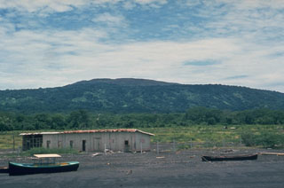 The profile of Cosigüina is not particularly impressive when viewed from its NE flank along the coast of the Gulf of Fonseca near the town of Potosí. The broad low-angle slopes of Cosigüina rise only 872 m above the coast and give little hint of the dramatic caldera that cuts the summit. Pyroclastic flows from the 1835 eruption reached the northern coast of the 20-km-wide Cosigüina Peninsula and formed new ephemeral islands in the Gulf of Fonseca.
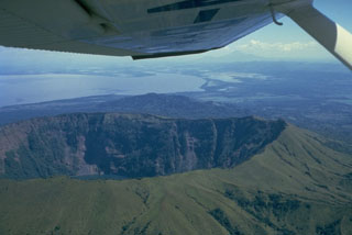 The summit of Cosigüina volcano, seen here from the west with the Gulf of Fonseca in the background and the border with Honduras at the upper left, contains a 2 x 2.4 km wide caldera with steep-sided, 500-m-high walls. The upper flanks of the volcano are only partially forested after a devastating eruption in 1835 produced pyroclastic flows and surges that reached the coast and fountain-fed lava flows that blanketed the upper eastern and western flanks. The peak in the distance below the right side of the wing is San Cristóbal volcano.
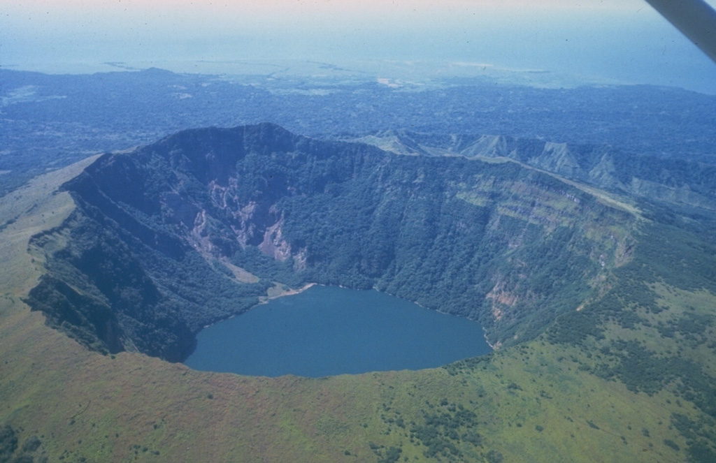
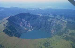 Cosigüina, seen here from the east, is a low basaltic-to-andesitic composite volcano that forms a large peninsula at the NW tip of Nicaragua along the Gulf of Fonseca. The 872-m-high volcano has a pronounced somma rim, which forms the ridge seen here at the right behind the far crater rim. The younger cone is truncated by a large elliptical prehistorical summit caldera 2 x 2.4 km in diameter and 500 m deep, which is now filled by a lake. It was the source of a major explosive eruption in 1835, Nicaragua's largest during historical time.
 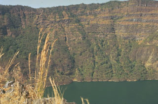 The steep-sided caldera walls of Cosigüina volcano rise 500 m above a lake on the caldera floor. Inter-bedded gray lava flows and brownish pyroclastic deposits forming the pre-caldera stratovolcano are exposed in the far wall. Observers of Cosigüina prior to the catastrophic 1835 eruption described the volcano as being of low height, with a flat top, suggesting that the caldera was in existence prior to the eruption.
 The broad Cosigüina stratovolcano (also spelled Cosegüina), is seen here from the SE across the Gulf of Fonseca. Cosigüina is the NW-most of a chain of active volcanoes stretching across Nicaragua. The 872-m-high volcano is truncated by a 2 x 2.4 km wide caldera that is filled by a lake. In 1835 Cosigüina was the source of Nicaragua's largest historical eruption, which produced detonations heard as far away as Guatemala. Pyroclastic flows and surges reached the Gulf of Fonseca and produced ephemeral islands.
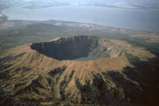 A dramatic aerial view from the NW shows Cosigüina volcano with its 2.4-km-wide caldera. One of Central America's largest historical eruptions began on January 20, 1835. Detonations were heard in Jamaica, Venezuela, and Colombia, and ash fell throughout Central America and southern México. Pyroclastic flows and surges reached the Gulf of Fonseca (background), and fountain-fed lava flows mantled portions of the upper flanks. Although the eruption devastated croplands and livestock, there were few human fatalities.
 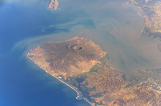 Cosigüina volcano forms the northern half of a 25-km-wide peninsula extending NW-ward into the Gulf of Fonseca. A 2-km-wide caldera, partially filled by a lake, truncates the summit of the volcano, and the scarp of a larger older caldera is visible to the NW. Pyroclastic flows from the catastrophic 1835 eruption, the largest in Nicaragua during historical time, reached the Gulf of Fonseca. The volcanic island of Meanguera in the El Salvador side of the Gulf of Fonseca is visible at the top left.
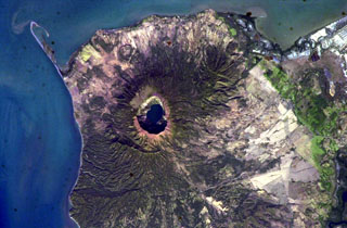 The steep-walled, lake-filled summit caldera of Cosigüina volcano is prominent in this NASA International Space Station image with north to the upper left. Bahia el Rosario lies to the right of the elongate peninsula at the upper left with Punta San Jose at its tip, and the town of Potosi is at the top center. The scarp of an older caldera rim forms Filete Cresta Montosa, the semi-arcuate ridge below the summit caldera. This scarp continues in a more subdued form to the northern side of the volcano.
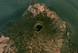 The Cosigüina caldera, 2.5 km wide and more than 500 m deep, is in the center of this December 2019 Planet Labs satellite image monthly mosaic (N is at the top; this image is approximately 25 km across). The ridge SE of the caldera is the Loma San Juan lava flows, and the El Barranco Maar is NNE of the caldera. The arcuate ridge to the W is the Filete Cresta Montosa, interpreted as the remains of an older caldera.
There are no samples for Cosigüina in the Smithsonian's NMNH Department of Mineral Sciences Rock and Ore collection.
| Copernicus Browser | The Copernicus Browser replaced the Sentinel Hub Playground browser in 2023, to provide access to Earth observation archives from the Copernicus Data Space Ecosystem, the main distribution platform for data from the EU Copernicus missions. |
| MIROVA | Middle InfraRed Observation of Volcanic Activity (MIROVA) is a near real time volcanic hot-spot detection system based on the analysis of MODIS (Moderate Resolution Imaging Spectroradiometer) data. In particular, MIROVA uses the Middle InfraRed Radiation (MIR), measured over target volcanoes, in order to detect, locate and measure the heat radiation sourced from volcanic activity. |
| MODVOLC Thermal Alerts | Using infrared satellite Moderate Resolution Imaging Spectroradiometer (MODIS) data, scientists at the Hawai'i Institute of Geophysics and Planetology, University of Hawai'i, developed an automated system called MODVOLC to map thermal hot-spots in near real time. For each MODIS image, the algorithm automatically scans each 1 km pixel within it to check for high-temperature hot-spots. When one is found the date, time, location, and intensity are recorded. MODIS looks at every square km of the Earth every 48 hours, once during the day and once during the night, and the presence of two MODIS sensors in space allows at least four hot-spot observations every two days. Each day updated global maps are compiled to display the locations of all hot spots detected in the previous 24 hours. There is a drop-down list with volcano names which allow users to 'zoom-in' and examine the distribution of hot-spots at a variety of spatial scales. |
|
WOVOdat
Single Volcano View Temporal Evolution of Unrest Side by Side Volcanoes |
WOVOdat is a database of volcanic unrest; instrumentally and visually recorded changes in seismicity, ground deformation, gas emission, and other parameters from their normal baselines. It is sponsored by the World Organization of Volcano Observatories (WOVO) and presently hosted at the Earth Observatory of Singapore.
GVMID Data on Volcano Monitoring Infrastructure The Global Volcano Monitoring Infrastructure Database GVMID, is aimed at documenting and improving capabilities of volcano monitoring from the ground and space. GVMID should provide a snapshot and baseline view of the techniques and instrumentation that are in place at various volcanoes, which can be use by volcano observatories as reference to setup new monitoring system or improving networks at a specific volcano. These data will allow identification of what monitoring gaps exist, which can be then targeted by remote sensing infrastructure and future instrument deployments. |
| Volcanic Hazard Maps | The IAVCEI Commission on Volcanic Hazards and Risk has a Volcanic Hazard Maps database designed to serve as a resource for hazard mappers (or other interested parties) to explore how common issues in hazard map development have been addressed at different volcanoes, in different countries, for different hazards, and for different intended audiences. In addition to the comprehensive, searchable Volcanic Hazard Maps Database, this website contains information about diversity of volcanic hazard maps, illustrated using examples from the database. This site is for educational purposes related to volcanic hazard maps. Hazard maps found on this website should not be used for emergency purposes. For the most recent, official hazard map for a particular volcano, please seek out the proper institutional authorities on the matter. |
| IRIS seismic stations/networks | Incorporated Research Institutions for Seismology (IRIS) Data Services map showing the location of seismic stations from all available networks (permanent or temporary) within a radius of 0.18° (about 20 km at mid-latitudes) from the given location of Cosigüina. Users can customize a variety of filters and options in the left panel. Note that if there are no stations are known the map will default to show the entire world with a "No data matched request" error notice. |
| UNAVCO GPS/GNSS stations | Geodetic Data Services map from UNAVCO showing the location of GPS/GNSS stations from all available networks (permanent or temporary) within a radius of 20 km from the given location of Cosigüina. Users can customize the data search based on station or network names, location, and time window. Requires Adobe Flash Player. |
| DECADE Data | The DECADE portal, still in the developmental stage, serves as an example of the proposed interoperability between The Smithsonian Institution's Global Volcanism Program, the Mapping Gas Emissions (MaGa) Database, and the EarthChem Geochemical Portal. The Deep Earth Carbon Degassing (DECADE) initiative seeks to use new and established technologies to determine accurate global fluxes of volcanic CO2 to the atmosphere, but installing CO2 monitoring networks on 20 of the world's 150 most actively degassing volcanoes. The group uses related laboratory-based studies (direct gas sampling and analysis, melt inclusions) to provide new data for direct degassing of deep earth carbon to the atmosphere. |
| Large Eruptions of Cosigüina | Information about large Quaternary eruptions (VEI >= 4) is cataloged in the Large Magnitude Explosive Volcanic Eruptions (LaMEVE) database of the Volcano Global Risk Identification and Analysis Project (VOGRIPA). |
| EarthChem | EarthChem develops and maintains databases, software, and services that support the preservation, discovery, access and analysis of geochemical data, and facilitate their integration with the broad array of other available earth science parameters. EarthChem is operated by a joint team of disciplinary scientists, data scientists, data managers and information technology developers who are part of the NSF-funded data facility Integrated Earth Data Applications (IEDA). IEDA is a collaborative effort of EarthChem and the Marine Geoscience Data System (MGDS). |

