Tectonic seismicity between Apoyo and Masaya in July 2000
[The following was originally included within the Masaya report, not as a stand-alone report about Apoyo.]
July 2000 seismicity near Masaya and Laguna de Apoyo. During July 2000 there were over 300 earthquakes near Laguna de Apoyo (Apoyo volcano) and Masaya. The earthquakes, determined to be of tectonic rather than volcanic origin, caused surficial damage at both volcanoes.
At 1329 on 6 July a small M 2 earthquake occurred near the N rim of Laguna de Apoyo that was followed at 1330 by a M 5.4 earthquake (figure 1). It was located ~32 km SE of Managua, at 11.96°N, 86.02°E, with a focal depth less than 1 km (figure 2). The earthquake was felt in most of Nicaragua and was most strongly felt in the cities of Managua (Modified Mercalli V-VI) and Masaya (VI), and in the region near Laguna de Apoyo (maximum intensity of VII or VIII). The earthquake caused numerous landslides down the volcano's crater walls and surface faulting was observed. In towns located in the epicentral zone, trees and electric lines fell and many houses were partially or totally destroyed. About 70 people were injured and four children were killed by collapsing walls or roofs of homes. At Masaya volcano, ~8 km from the epicenter, there were minor collapses of Santiago crater's walls. No change in degassing was observed at the volcano.
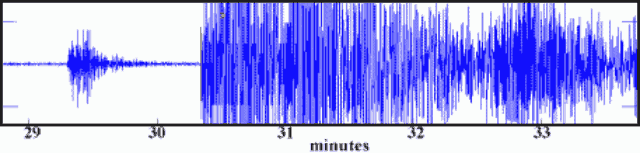 |
Figure 1. Seismogram showing the M 2 and M 5.4 earthquakes near the Masaya volcano station on 6 July 2000. Courtesy of INETER. |
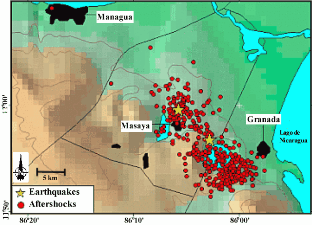 |
Figure 2. Epicenters near Masaya for the M 5.4 earthquake on 6 July, and the M 4.8 earthquake on 25 July 2000 (stars). The aftershocks from these earthquakes are also shown (small circles). Courtesy of INETER. |
Immediately after the earthquake there were many smaller, shallow earthquakes in a zone that includes the area between Masaya, Laguna de Apoyo, and W of Granada (figure 2). In the epicentral zone property was destroyed, cracks opened in the ground, landslides occurred, and trees fell. Several landslides occurred at the edges and steep walls of Laguna de Apoyo. A large number of earthquakes continued until 10 July (figure 3 and table 1). The number of earthquakes then diminished until 1554 on 25 July when a M 4.8 earthquake took place, initiating a series of smaller earthquakes that lasted until about 27 July.
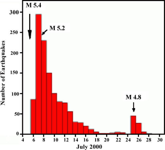 |
Figure 3. Graph showing the number of earthquakes in the Masaya region between 4 and 30 July 2000. Courtesy of INETER. |
Table 1. A summary of earthquakes in vicinity of Masaya and Laguna de Apoyo in early July 2000. Courtesy of INETER.
| Date | Time | Number of daily earthquakes | Maximum magnitude |
| 07 Jul 2000 | 1330 | 180 | 5.2 |
| 08 Jul 2000 | 1100 | 70 | 3.8 |
| 09 Jul 2000 | 1200 | 81 | 3.6 |
| 10 Jul 2000 | 1800 | 27 | 3.1 |
| 11 Jul 2000 | 1800 | 6 | 3.3 |
| 13 Jul 2000 | 1800 | 16 | 2.8 |
The July earthquakes were the most destructive seismic events since the 1972 Managua earthquake. The epicentral zone of the July 2000 earthquakes correlates with the same active zones of past earthquakes, which are caused by fault movement between the Cocos and Caribbean plates.
Information Contacts: Wilfried Strauch and Virginia Tenorio, Dirección General de Geofísica, Instituto Nicaragüense de Estudios Territoriales (INETER), Apartado 1761, Managua, Nicaragua (URL: http://www.ineter.gob.ni/).
The Global Volcanism Program has no Weekly Reports available for Apoyo.
Reports are organized chronologically and indexed below by Month/Year (Publication Volume:Number), and include a one-line summary. Click on the index link or scroll down to read the reports.
No fumarolic activity; lake temperature measured
No fumarolic activity or hot springs were observed 18 January 1988 at locations previously reported active. Lake surface temperature was 28.2-29.1°C at 0940.
Information Contacts: B. van Wyk de Vries, H. Rymer, and G.C. Brown, Dept of Earth Sciences, Open Univ; P. Hradecky and H. Taleno, INETER.
No fumarolic or seismic activity
"No fumarolic or seismic activity was detected in 1990."
Information Contacts: B. van Wyk de Vries, O. Castellón, A. Murales, and V. Tenorio, INETER.
On 8 June, a M 3.7 tectonic earthquake struck this reposing caldera
A swarm of seismic events was observed in June 1997, centered on the E flank of the Laguna de Apoyo. The strongest event was M 3.7 on 8 June. This and many other events were felt with maximum modified Mercalli intensity of IV in nearby villages and Granada city (10 km from Apoyo). The events were of tectonic character.
Information Contacts: Wilfried Strauch, Department of Geophysics, and Marta Navarro C., Department of Volcanoes, Instituto Nicaragüense de Estudios Territoriales (INETER), P.O. Box 1761, Managua, Nicaragua.
Tectonic seismicity between Apoyo and Masaya in July 2000
[The following was originally included within the Masaya report, not as a stand-alone report about Apoyo.]
July 2000 seismicity near Masaya and Laguna de Apoyo. During July 2000 there were over 300 earthquakes near Laguna de Apoyo (Apoyo volcano) and Masaya. The earthquakes, determined to be of tectonic rather than volcanic origin, caused surficial damage at both volcanoes.
At 1329 on 6 July a small M 2 earthquake occurred near the N rim of Laguna de Apoyo that was followed at 1330 by a M 5.4 earthquake (figure 1). It was located ~32 km SE of Managua, at 11.96°N, 86.02°E, with a focal depth less than 1 km (figure 2). The earthquake was felt in most of Nicaragua and was most strongly felt in the cities of Managua (Modified Mercalli V-VI) and Masaya (VI), and in the region near Laguna de Apoyo (maximum intensity of VII or VIII). The earthquake caused numerous landslides down the volcano's crater walls and surface faulting was observed. In towns located in the epicentral zone, trees and electric lines fell and many houses were partially or totally destroyed. About 70 people were injured and four children were killed by collapsing walls or roofs of homes. At Masaya volcano, ~8 km from the epicenter, there were minor collapses of Santiago crater's walls. No change in degassing was observed at the volcano.
|
Figure 1. Seismogram showing the M 2 and M 5.4 earthquakes near the Masaya volcano station on 6 July 2000. Courtesy of INETER. |
|
Figure 2. Epicenters near Masaya for the M 5.4 earthquake on 6 July, and the M 4.8 earthquake on 25 July 2000 (stars). The aftershocks from these earthquakes are also shown (small circles). Courtesy of INETER. |
Immediately after the earthquake there were many smaller, shallow earthquakes in a zone that includes the area between Masaya, Laguna de Apoyo, and W of Granada (figure 2). In the epicentral zone property was destroyed, cracks opened in the ground, landslides occurred, and trees fell. Several landslides occurred at the edges and steep walls of Laguna de Apoyo. A large number of earthquakes continued until 10 July (figure 3 and table 1). The number of earthquakes then diminished until 1554 on 25 July when a M 4.8 earthquake took place, initiating a series of smaller earthquakes that lasted until about 27 July.
|
Figure 3. Graph showing the number of earthquakes in the Masaya region between 4 and 30 July 2000. Courtesy of INETER. |
Table 1. A summary of earthquakes in vicinity of Masaya and Laguna de Apoyo in early July 2000. Courtesy of INETER.
| Date | Time | Number of daily earthquakes | Maximum magnitude |
| 07 Jul 2000 | 1330 | 180 | 5.2 |
| 08 Jul 2000 | 1100 | 70 | 3.8 |
| 09 Jul 2000 | 1200 | 81 | 3.6 |
| 10 Jul 2000 | 1800 | 27 | 3.1 |
| 11 Jul 2000 | 1800 | 6 | 3.3 |
| 13 Jul 2000 | 1800 | 16 | 2.8 |
The July earthquakes were the most destructive seismic events since the 1972 Managua earthquake. The epicentral zone of the July 2000 earthquakes correlates with the same active zones of past earthquakes, which are caused by fault movement between the Cocos and Caribbean plates.
Information Contacts: Wilfried Strauch and Virginia Tenorio, Dirección General de Geofísica, Instituto Nicaragüense de Estudios Territoriales (INETER), Apartado 1761, Managua, Nicaragua (URL: http://www.ineter.gob.ni/).
This compilation of synonyms and subsidiary features may not be comprehensive. Features are organized into four major categories: Cones, Craters, Domes, and Thermal Features. Synonyms of features appear indented below the primary name. In some cases additional feature type, elevation, or location details are provided.
Domes |
||||
| Feature Name | Feature Type | Elevation | Latitude | Longitude |
| Apoyoito | Dome | |||
| Cerritito | Dome | |||
| Cerrito, El | Dome | |||
|
|
||||||||||||||||||
The Global Volcanism Program is not aware of any Holocene eruptions from Apoyo. If this volcano has had large eruptions (VEI >= 4) prior to 10,000 years ago, information might be found on the Apoyo page in the LaMEVE (Large Magnitude Explosive Volcanic Eruptions) database, a part of the Volcano Global Risk Identification and Analysis Project (VOGRIPA).
There is no Deformation History data available for Apoyo.
There is no Emissions History data available for Apoyo.
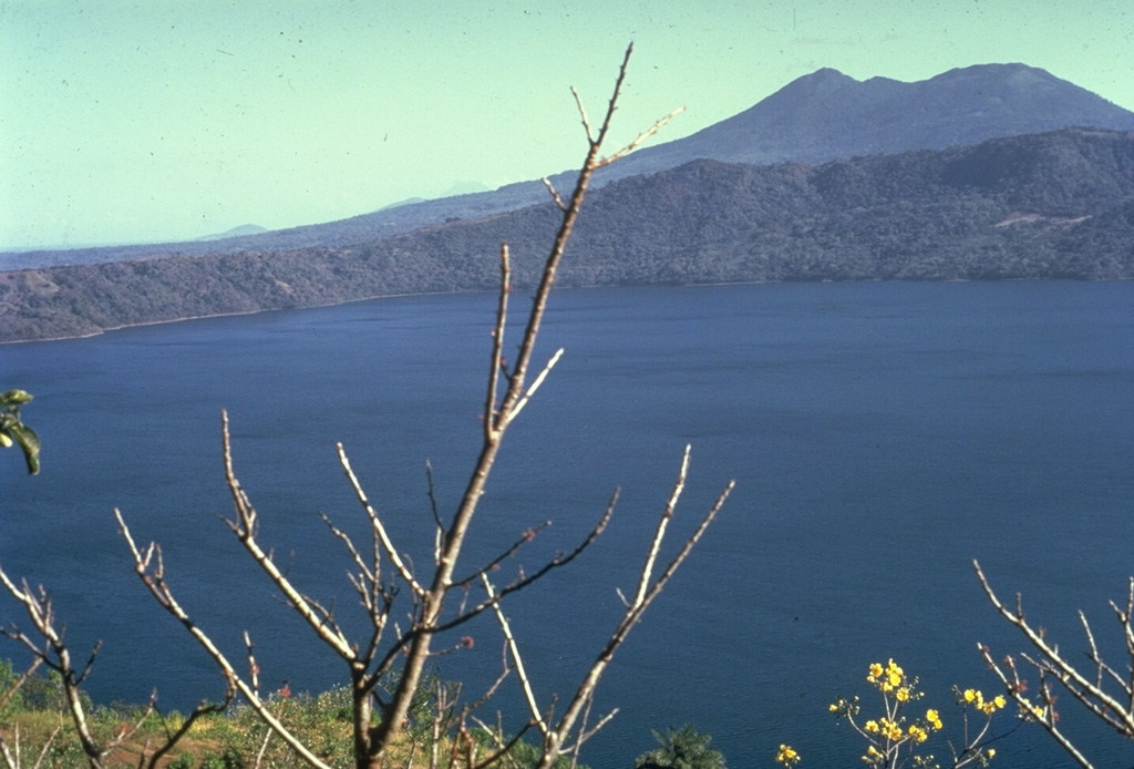
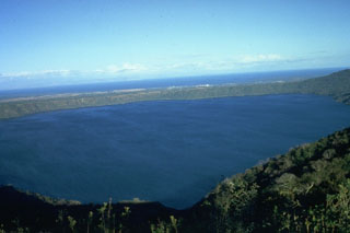 The 7-km-wide, lake-filled Apoyo caldera is seen here from the W with Lake Nicaragua in the distance beyond its low eastern caldera rim. The surface of Laguna de Apoyo is 78 m above sea level. The steep caldera walls rise about 100 m along the eastern rim and up to 500 m along the western rim (foreground). The caldera was formed during two major dacitic explosive eruptions radiocarbon dated at about 23,000 years BP.
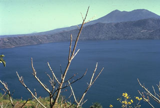 The 7-km-wide, lake-filled Apoyo caldera, seen here from the NW with Mombacho volcano in the background, is a large silicic volcanic center immediately SE of Masaya caldera. An early shield volcano constructed of basaltic-to-andesitic lava flows and small rhyodacitic lava domes collapsed following two major dacitic explosive eruptions about 23,000 years ago. Post-caldera ring-fracture eruptions formed the Granada cinder cones and La Joya collapse craters along fracture systems to the east of the caldera. The age of the latest activity is not known.
 The circular Apoyo caldera is filled by beautiful Laguna de Apoyo. The NE caldera wall in the background rises about 120 m above the surface of the lake, which is only 78 m above sea level. The only road access to the lake is along its western shore. The caldera was formed by collapse along near-vertical faults following two major dacitic explosive eruptions about 23,000 years ago from a vent area inferred to be near the NE part of the caldera.
 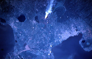 A vigorous steam plume pours from Masaya volcano in this November 9, 1984 Space Shuttle image taken near the end of a two-decade-long eruptive episode. North lies to the lower right, with Lake Nicaragua at the lower left and Lake Managua at the lower right. To the left of the plume from Santiago crater is Lake Masaya (ponded against the rim of Masaya caldera) and the circular lake-filled Apoyo caldera. The two caldera lakes at the lower right are Apoyeque (light blue) and Jiloa (dark-colored), across the bay from the city of Managua.
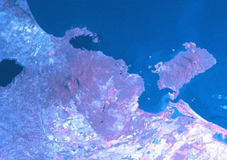 Two major scarps cutting Mombacho volcano (left-center) were the sources of major debris avalanches. The arcuate peninsula and island chain extending into Lake Nicaragua (known as Las Isletas or Isletas de Granada) was produced by collapse of Mombacho to the NE. The island at the right is Zapatera, a small shield volcano and maar complex. The lake at the far left fills late-Pleistocene Apoyo caldera, and the roughly N-S-trending Granada cinder cone alignment lies NNW of Mombacho and east of Lake Apoyo in this NASA Space Shuttle image (with north to the upper left).
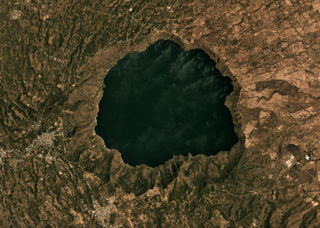 The 6.5-km-diameter Apoyo caldera formed during two Plinian eruptions around 24,000 years ago, seen in this March 2019 Planet Labs satellite image monthly mosaic (N is at the top; this image is approximately 13 km across). The caldera was created within broad lavas that formed the previous edifice.
Maps are not currently available due to technical issues.
The maps shown below have been scanned from the GVP map archives and include the volcano on this page. Clicking on the small images will load the full 300 dpi map. Very small-scale maps (such as world maps) are not included.
There are no samples for Apoyo in the Smithsonian's NMNH Department of Mineral Sciences Rock and Ore collection.
| Copernicus Browser | The Copernicus Browser replaced the Sentinel Hub Playground browser in 2023, to provide access to Earth observation archives from the Copernicus Data Space Ecosystem, the main distribution platform for data from the EU Copernicus missions. |
|
WOVOdat
Single Volcano View Temporal Evolution of Unrest Side by Side Volcanoes |
WOVOdat is a database of volcanic unrest; instrumentally and visually recorded changes in seismicity, ground deformation, gas emission, and other parameters from their normal baselines. It is sponsored by the World Organization of Volcano Observatories (WOVO) and presently hosted at the Earth Observatory of Singapore.
GVMID Data on Volcano Monitoring Infrastructure The Global Volcano Monitoring Infrastructure Database GVMID, is aimed at documenting and improving capabilities of volcano monitoring from the ground and space. GVMID should provide a snapshot and baseline view of the techniques and instrumentation that are in place at various volcanoes, which can be use by volcano observatories as reference to setup new monitoring system or improving networks at a specific volcano. These data will allow identification of what monitoring gaps exist, which can be then targeted by remote sensing infrastructure and future instrument deployments. |
| IRIS seismic stations/networks | Incorporated Research Institutions for Seismology (IRIS) Data Services map showing the location of seismic stations from all available networks (permanent or temporary) within a radius of 0.18° (about 20 km at mid-latitudes) from the given location of Apoyo. Users can customize a variety of filters and options in the left panel. Note that if there are no stations are known the map will default to show the entire world with a "No data matched request" error notice. |
| UNAVCO GPS/GNSS stations | Geodetic Data Services map from UNAVCO showing the location of GPS/GNSS stations from all available networks (permanent or temporary) within a radius of 20 km from the given location of Apoyo. Users can customize the data search based on station or network names, location, and time window. Requires Adobe Flash Player. |
| Large Eruptions of Apoyo | Information about large Quaternary eruptions (VEI >= 4) is cataloged in the Large Magnitude Explosive Volcanic Eruptions (LaMEVE) database of the Volcano Global Risk Identification and Analysis Project (VOGRIPA). |
| EarthChem | EarthChem develops and maintains databases, software, and services that support the preservation, discovery, access and analysis of geochemical data, and facilitate their integration with the broad array of other available earth science parameters. EarthChem is operated by a joint team of disciplinary scientists, data scientists, data managers and information technology developers who are part of the NSF-funded data facility Integrated Earth Data Applications (IEDA). IEDA is a collaborative effort of EarthChem and the Marine Geoscience Data System (MGDS). |

