The Global Volcanism Program has no activity reports available for El Valle.
The Global Volcanism Program has no Weekly Reports available for El Valle.
The Global Volcanism Program has no Bulletin Reports available for El Valle.
|
|
||||||||||||||||||||||||||
The Global Volcanism Program is not aware of any Holocene eruptions from El Valle. If this volcano has had large eruptions (VEI >= 4) prior to 12,000 years ago, information might be found on the El Valle page in the LaMEVE (Large Magnitude Explosive Volcanic Eruptions) database, a part of the Volcano Global Risk Identification and Analysis Project (VOGRIPA).
This compilation of synonyms and subsidiary features may not be comprehensive. Features are organized into four major categories: Cones, Craters, Domes, and Thermal Features. Synonyms of features appear indented below the primary name. In some cases additional feature type, elevation, or location details are provided.
Craters |
||||
| Feature Name | Feature Type | Elevation | Latitude | Longitude |
| Mar, Río | Crater | |||
| Mata Ahogado | Crater | |||
| Mesa, La | Pleistocene caldera | |||
| Valle de Antón, El | Pleistocene caldera | |||
Domes |
||||
| Feature Name | Feature Type | Elevation | Latitude | Longitude |
| Caracoral, Cerro | Dome | 1040 m | ||
| Gaital, Cerro | Dome | 1185 m | ||
| Pajita, Cerro | Dome | |||
| Pilón, Cerro | Dome | 1045 m | ||
| Silla, Cerro la | Dome | |||
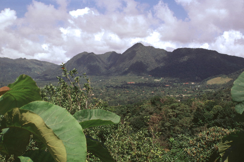
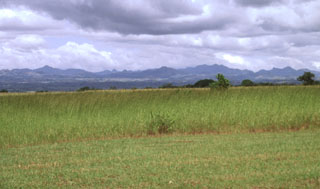 The broad irregular ridge on the horizon NE of the Pacific coastal plain is El Valle volcano in Panama. El Valle de Antón caldera is within the volcanic complex and post-caldera lava domes can be seen in the center of the horizon. Late-Pleistocene Plinian eruptions from El Valle have produced pyroclastic flows that reached the coast. Tertiary volcanic centers surround the caldera complex.
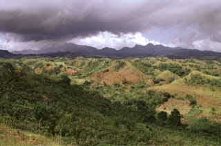 An eroded pyroclastic flow deposit extends to the SE from El Valle caldera. Pyroclastic flows from phreatomagmatic eruptions about 50,000 to 34,000 years ago traveled more than 25 km to the Pacific coast of Panamá and their deposits cover the southern and eastern flanks of the volcano.
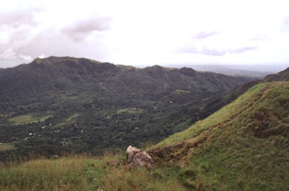 El Valle de Antón caldera (left) is seen here where a late-Pleistocene lake occupied the caldera floor and persisted until it drained sometime during the Holocene. Cerro Cara Iguana (upper left) on the caldera rim contains El Hato pyroclastic flow deposits from caldera formation about 1.1-1.3 million years ago. A crater just out of view outside the SW caldera rim at the right was the inferred source of the India Dormida ignimbrite that was erupted about 220,000 years ago.
 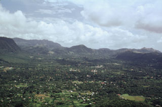 The town of El Valle occupies the El Valle de Antón caldera floor. This view looks across the 6-km-wide caldera from La India Dormida on the western rim. A lake once covered the caldera floor, contributing to large phreatoplinian eruptions during the late Pleistocene. At the far-left is Cerro Caracoral, the easternmost of three lava domes along the northern caldera margin. More recent Plinian eruptions originated from the Mata Ahogado crater, east of the caldera rim.
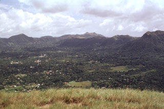 The El Valle de Antón SW caldera rim reaches 300 m above the caldera floor. The caldera formed during major explosive eruptions about 1.1-1.3 million years ago. A former caldera lake contributed to phreatomagmatic and phreatic eruptions that continued into the late Pleistocene. More than 90 m of lake sediments were deposited on the caldera floor prior to draining of the lake.
 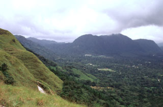 The post-caldera Cerro Pajita, Cerro Gaital, and Cerro Caracoral lava domes (seen left to right from La India Dormida on the western caldera rim) formed along an E-W trend about 900,000 years ago. The easternmost dome is Cerro Caracoral. Gabbro xenoliths are common in the central dome, Cerro Gaital. The Río Mar pyroclastic flows were produced about 40,000-50,000 years ago from a vent on the caldera floor between the Gaital and Pajita domes.
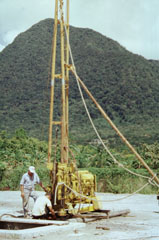 This drill rig on the floor of El Valle de Antón caldera is part of a major geothermal exploration program at El Valle volcano. In the background to the north is Cerro Gaital, the highest of three post-caldera lava domes along the northern caldera rim.
 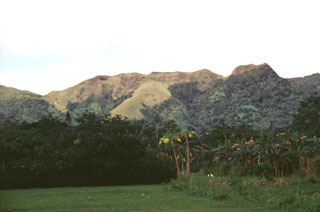 La India Dormida is a portion of the western rim of El Valle de Antón caldera. A hiking trail leads to the saddle (left) at the base (left) and then to its summit, which rises 300 m above the caldera floor. The caldera wall exposes Tertiary Iguana pyroclastic flow deposits that are overlain by the Tertiary Piedra lava flow.
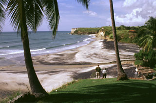 These headlands along the Pacific coast south of El Valle volcano consist of ignimbrite deposits from late Pleistocene eruptions. The latest Plinian eruption, about 34,000 years ago, produced pyroclastic flows that reached as far as 25 km from the volcano and emplaced deposits along its southern and eastern flanks.
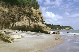 Cliffs along the southern coast of Panamá, west of Panama City, expose ignimbrite deposits from El Valle volcano.
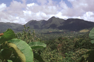 Three lava domes formed along the northern margin of the youngest of El Valle caldera, 80 km SW of Panama City. Cerro Pajita (left), Cerro Gaital (center), and Cerro Caracoral (right) rise above the caldera floor in this view from the SW caldera rim. The 6-km-wide El Valle de Antón caldera formed about 1 million years ago.
There are no samples for El Valle in the Smithsonian's NMNH Department of Mineral Sciences Rock and Ore collection.
| Copernicus Browser | The Copernicus Browser replaced the Sentinel Hub Playground browser in 2023, to provide access to Earth observation archives from the Copernicus Data Space Ecosystem, the main distribution platform for data from the EU Copernicus missions. |
|
WOVOdat
Single Volcano View Temporal Evolution of Unrest Side by Side Volcanoes |
WOVOdat is a database of volcanic unrest; instrumentally and visually recorded changes in seismicity, ground deformation, gas emission, and other parameters from their normal baselines. It is sponsored by the World Organization of Volcano Observatories (WOVO) and presently hosted at the Earth Observatory of Singapore.
GVMID Data on Volcano Monitoring Infrastructure The Global Volcano Monitoring Infrastructure Database GVMID, is aimed at documenting and improving capabilities of volcano monitoring from the ground and space. GVMID should provide a snapshot and baseline view of the techniques and instrumentation that are in place at various volcanoes, which can be use by volcano observatories as reference to setup new monitoring system or improving networks at a specific volcano. These data will allow identification of what monitoring gaps exist, which can be then targeted by remote sensing infrastructure and future instrument deployments. |
| IRIS seismic stations/networks | Incorporated Research Institutions for Seismology (IRIS) Data Services map showing the location of seismic stations from all available networks (permanent or temporary) within a radius of 0.18° (about 20 km at mid-latitudes) from the given location of El Valle. Users can customize a variety of filters and options in the left panel. Note that if there are no stations are known the map will default to show the entire world with a "No data matched request" error notice. |
| UNAVCO GPS/GNSS stations | Geodetic Data Services map from UNAVCO showing the location of GPS/GNSS stations from all available networks (permanent or temporary) within a radius of 20 km from the given location of El Valle. Users can customize the data search based on station or network names, location, and time window. Requires Adobe Flash Player. |
| Large Eruptions of El Valle | Information about large Quaternary eruptions (VEI >= 4) is cataloged in the Large Magnitude Explosive Volcanic Eruptions (LaMEVE) database of the Volcano Global Risk Identification and Analysis Project (VOGRIPA). |
| EarthChem | EarthChem develops and maintains databases, software, and services that support the preservation, discovery, access and analysis of geochemical data, and facilitate their integration with the broad array of other available earth science parameters. EarthChem is operated by a joint team of disciplinary scientists, data scientists, data managers and information technology developers who are part of the NSF-funded data facility Integrated Earth Data Applications (IEDA). IEDA is a collaborative effort of EarthChem and the Marine Geoscience Data System (MGDS). |

