

Iceland Met Office (IMO) reported that electrical conductivity levels in the Skálmur River, which drains from the Sandfellsjökull glacier on the E part of the Mýrdalsjökull ice cap that covers Katla, began to increase late on 26 July. Increased seismicity within the Katla caldera began to be detected around 0600 on 27 July. Unrest significantly increased at around 1100 and a jökulhlaup (a glacier-outburst flood) began in the river at around 1320. Reports indicated increased sulfur odors originating from Mýrdalsjökull, specifically in Hólaskjól. As a precaution, and to account for the possibility of volcanic unrest, at 1554 IMO raised the Aviation Color Code to Yellow, the second lowest level on a four-color scale. The flood water flowed over a 1-km-long section of Highway 1 (also known as the Ring Road), damaging the road in several places, and washing away part of the road located next to the Skálmur River bridge. According to a news article local authorities closed the road between Víkur and Kirkjubæjarklausturs and evacuated Sólheimajökull, an area near the glacier, and a service area the end of the Sólheimajökull road. The peak flow rate may have been as high as 1,000 cubic meters per second, making the jökulhlaup significantly larger than previous events in 2011 and 1950. Electrical conductivity levels indicated that the flooding had significantly decreased later that night, though the report noted that it may be days before the rivers return to seasonally normal levels. At 1031 on 29 July IMO lowered the Aviation Color Code to Green, noting that activity at Mýrdalsjökull had returned to normal levels, and water levels and electrical conductivity in the Skálmur River had decreased.
Sources: Icelandic Meteorological Office (IMO), Icelandic National Broadcasting Service (RUV), Icelandic National Broadcasting Service (RUV)
Jökulhlaup and elevated seismicity in 2011; filming sparks eruption fears
Microseismicity preceded and accompanied a jökulhlaup (a glacier-outburst flood) on 9 July 2011, as reported by the Iceland Met Office (IMO). The jökulhlaup escaped from under Mýrdalsjökull, the glacier that rests above Iceland's Katla volcano, its 10 x 14 km caldera, and environs (figure 4). IMO reported that microseismicity was registered near several ice cauldrons in the caldera for a few weeks prior to the event (figure 5). Peak harmonic tremor on 8 July coincided with rising water levels and increased water conductivity, as measured by the main flood gauge (figure 6; gauge is at red triangle on figure 4).
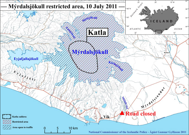 |
Figure 4. A map of road closures and restricted areas of Mýrdalsjökull glacier resulting from the 9 July 2011 jökulhlaup at Katla (see key, lower left). The town of Vík is shown near the bottom (in black), and the main road through the area is shown in red; the trace of Katla caldera is shown in black and labeled. The main flood gauge was on the bridge across the Múlakvísl river; both were destroyed in the jökulhlaup event (red triangle). Inset shows the geographic location of Katla and Mýrdalsjökull in the S of Iceland. Restricted areas map modified from ágúst Gunnar Gylfason of the National Commissioner of the Icelandic Police-Department of Civil Protection and Emergency Management; index map modified from Ginkgo Maps. |
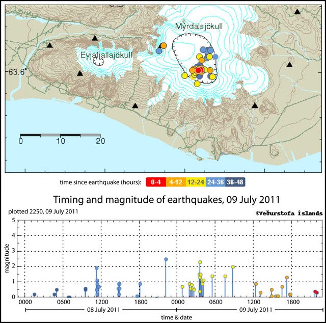 |
Figure 5. Map (top) and plot (bottom) of the seismicity recorded during 8-9 July 2011 at Katla. Colors indicate the timing of epicenters and their respective plotted magnitudes, recorded as late as 2250 on 9 July 2011, according to the scheme shown below the map. Black triangles indicate seismic monitoring stations. Courtesy of Iceland Met Office (IMO). |
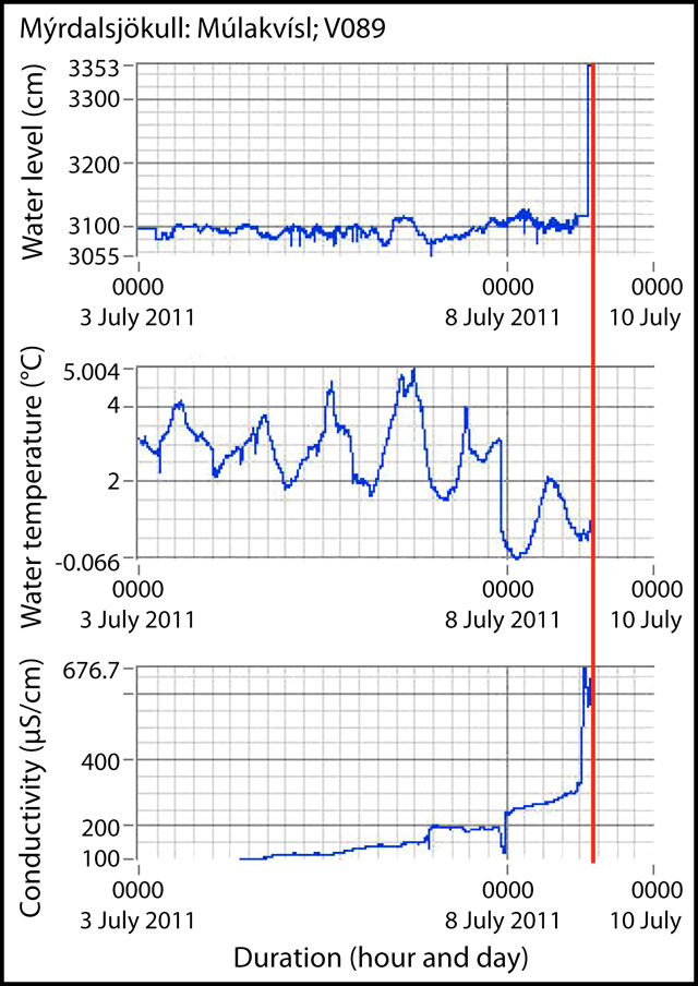 |
Figure 6. Running plots of (a) water level, (b) water temperature, and (c) water conductivity at the main flood gauge of the Múlakvísl river during 3-9 July 2011. The plots show rising water level and conductivity that were coincident with peak harmonic tremor. The plots stop abruptly (red vertical line) when the gauge was destroyed along with the bridge crossing the Múlakvísl river. Courtesy of Iceland Met Office (IMO). |
IMO reported that, on the same day, the main flood gauge was damaged when flood waters reached the instrument near midnight; another station, normally not in the water, started recording rising water around 0400 on 9 July, and the water level there rose 5 m within 5 minutes (figure 7). When the flood reached the main road approximately one hour later, the main bridge over the Múlakvísl river was destroyed and the road was closed (red triangle, figure 41).
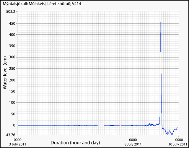 |
Figure 7. A running plot of water level at the second flood gauge (normally not submerged). The plot shows a significant rise in water level (5 m within 5 minutes). Courtesy of Iceland Met Office (IMO). |
According to the news source Morgunblaðið, 200 people were safely evacuated, and allowed to return to their homes by that afternoon. Morgunblaðið reported that analysis of the flood waters indicated that the flood was caused by geothermal water, but that a sub-glacial eruption at Katla could not be ruled out. IMO stated that the harmonic tremor declined on 9 July, following the jökulhlaup event. After observational flights, new cracks and cauldrons were reported in the ice of Mýrdalsjökull glacier (figure 8).
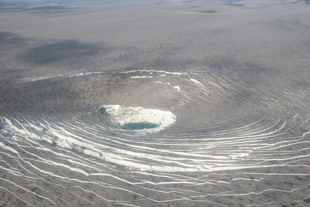 |
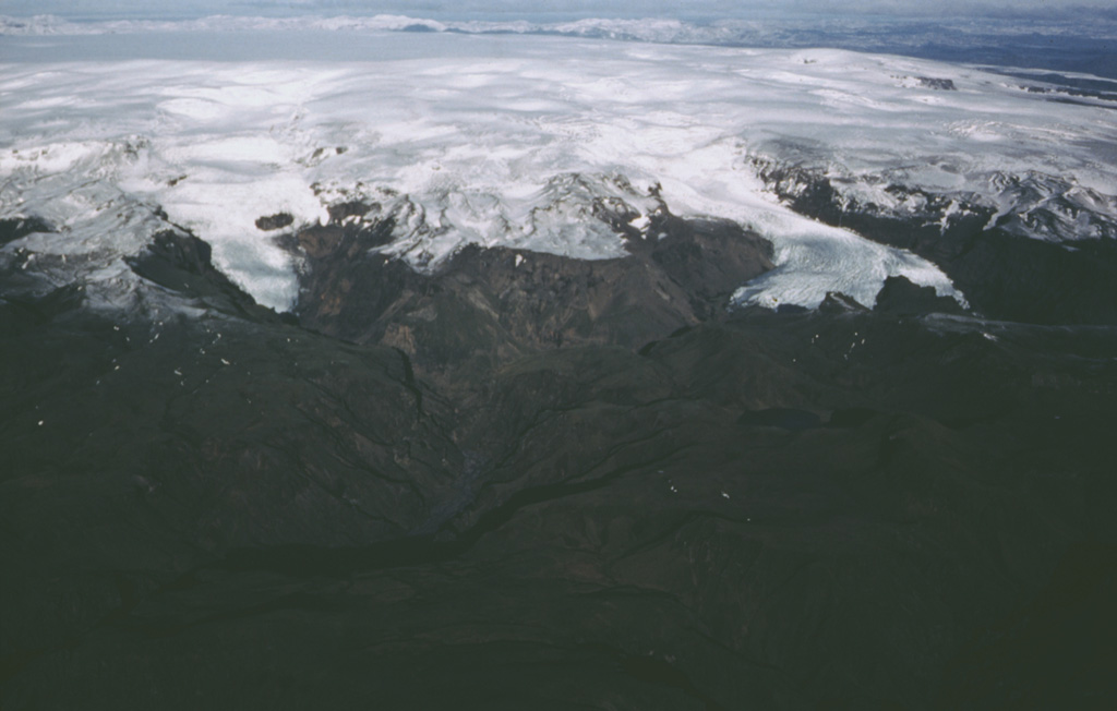
Figure 8. Cracking and subsidence of the Mýrdalsjökull glacier around an ice cauldron above the Katla caldera. Widespread gray tephra deposited on the ice surface is due to the 2010 Eyjafjallajökull eruption (BGVN 35:03, 35:04). Courtesy of the Icelandic Coast Guard. |
By 16 July, the National Commissioner of Icelandic Police in the Department of Civil Protection and Emergency Management reported that a new bridge had been built to replace the bridge destroyed in the jökulhlaup (figure 9).
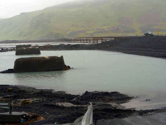 |
Figure 9. Photograph of the remains of the bridge crossing of the Múlakvísl river, destroyed in the jökulhlaup event on 9 July 2011. The new bridge, constructed by the 16 July 2011, can be seen in the background. Courtesy of John A. Stevenson. |
August-December seismicity. IMO reported increased seismicity under Mýrdalsjökull in October (figure 10). They reported that 512 earthquakes occurred, with ~ 380 originating within the Katla caldera; a large portion (nearly 100) of those 512 earthquakes occurred on one day near the beginning of October (figure 11). The largest reported earthquake was M 4, with seven being larger than M 3. On 8 November, an M 3.2 earthquake that originated in the S most part of the caldera was felt by residents in the town of Vík.
Overall, following the July 2011 jökulhlaup event, seismicity has increased above background levels of the past year. The seismic peak is noticeable with respect to the number of earthquakes, their largest magnitudes, and the clustering under Katla (figures 10 and 11). The largest earthquakes were as large, or slightly larger, than the other earthquakes of M 3 or greater in earlier episodes of unrest (i.e., 1999 and 2002-2004, figure 10). The bulk of the 2011 seismic increase occurred over a shallow depth range (within 4 km of the surface, figure 12).
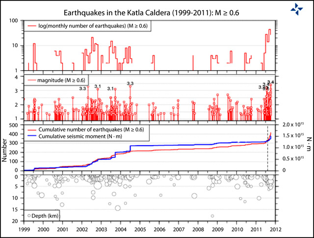 |
Figure 10. Plots of seismicity (greater than M 0.6) at Katla since 1999, showing the October 2011 seismicity in comparison with past episodes of non-eruptive unrest, such as in 1999 (sub-glacial eruption is uncertain in the GVP database) and 2002-2004. Plots (from the top) show: the monthly number of earthquakes (log scale); the magnitudes of earthquakes; cumulative number of earthquakes (red) and cumulative seismic moment (blue); and the focal depths of the located earthquakes. Courtesy of Iceland Met Office (IMO). |
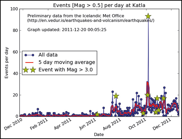 |
Figure 11. Seismic events (stronger than M 0.5) per day at Katla during December 2010-December 2011. Raw data is shown in blue, the 5 day moving average is shown in red, and events stronger than M 3.0 are indicated by gold stars. These trends highlight the increased seismicity of August-December 2011. Courtesy of the University of Edinburgh School of Geosciences. |
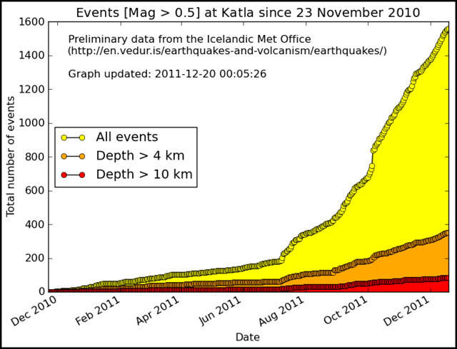 |
Figure 12. Cumulative number of seismic events (stronger than M 0.5) at Katla since 23 November 2010. All events are shown in yellow, and events originating at depths greater than 4 and 10 km are shown in orange and red, respectively. During the August-December 2011 increase in seismicity, the majority of the recorded events originated from shallow depths (less than 4 km). Courtesy of the University of Edinburgh School of Geosciences. |
Television filming sparks eruption fears. The Iceland Review reported that, in the early morning of 9 December, the Icelandic emergency hotline received calls from residents reporting bright lights on the slopes of Mýrdalsjökull. Callers feared that an eruption had started at Katla. The bright lights had also been noticed on a webcam by observers in Norway, who also enquired if there was an eruption. When the glacial slopes were inspected to find the cause of the lights, it was discovered that they were from film crews for the HBO series "Game of Thrones", who were filming in the early morning to capture the desired light conditions.
Information Contacts: Einar Kjartansson, Iceland Met Office (IMO), Bústaðavegi 9, 150 Reykjavík, Iceland (URL: http://en.vedur.is/); National Commissioner of the Icelandic Police-Department of Civil Protection and Emergency Management, Skúlagata 21, 101 Reykjavík, Iceland (URL: http://www.almannavarnir.is/); Ginkgo Maps (URL: http://ginkgomaps.com/); Morgunblaðið, Hádegismóum 2, 110 Reykjavík, Iceland (URL: http://mbl.is/); Icelandic Coast Guard, Skógarhlíð 14, 105 Reykjavík, Iceland (URL: http://www.lhg.is/); John A. Stevenson (URL: http://all-geo.org/volcan01010/); The University of Edinburgh School of Geosciences (URL: http://www.ed.ac.uk/schools-departments/geosciences); The Iceland Review, Borgartúni 23, 105 Reykjavík, Iceland (URL: http://www.icelandreview.com/).
2024: July
2023: May
2017: July
2016: August
| September
2011: July
| October
Iceland Met Office (IMO) reported that electrical conductivity levels in the Skálmur River, which drains from the Sandfellsjökull glacier on the E part of the Mýrdalsjökull ice cap that covers Katla, began to increase late on 26 July. Increased seismicity within the Katla caldera began to be detected around 0600 on 27 July. Unrest significantly increased at around 1100 and a jökulhlaup (a glacier-outburst flood) began in the river at around 1320. Reports indicated increased sulfur odors originating from Mýrdalsjökull, specifically in Hólaskjól. As a precaution, and to account for the possibility of volcanic unrest, at 1554 IMO raised the Aviation Color Code to Yellow, the second lowest level on a four-color scale. The flood water flowed over a 1-km-long section of Highway 1 (also known as the Ring Road), damaging the road in several places, and washing away part of the road located next to the Skálmur River bridge. According to a news article local authorities closed the road between Víkur and Kirkjubæjarklausturs and evacuated Sólheimajökull, an area near the glacier, and a service area the end of the Sólheimajökull road. The peak flow rate may have been as high as 1,000 cubic meters per second, making the jökulhlaup significantly larger than previous events in 2011 and 1950. Electrical conductivity levels indicated that the flooding had significantly decreased later that night, though the report noted that it may be days before the rivers return to seasonally normal levels. At 1031 on 29 July IMO lowered the Aviation Color Code to Green, noting that activity at Mýrdalsjökull had returned to normal levels, and water levels and electrical conductivity in the Skálmur River had decreased.
Sources: Icelandic Meteorological Office (IMO); Icelandic National Broadcasting Service (RUV); Icelandic National Broadcasting Service (RUV)
Iceland Met Office (IMO) reported that an intense seismic swarm began at Katla at 0941 on 4 May with three earthquakes larger than M 4 occurring beneath the caldera within about 10 minutes. The Aviation Color Code was raised to Yellow, the second lowest level on a four-color scale. According to a news article the three largest events were magnitudes 4.8, 4.7, and 4.5, adjusted from previous estimates of 4.5, 4.3, and 4.2. The larger earthquakes were felt in Thórsmörk and by residents in areas S of Mýrdalsjökull glacier (the glacier that covers Katla). The intensity of the events decreased after noon, though smaller earthquakes continued. Seismicity had decreased significantly by the next day with only five events recorded during 0000-0915 on 5 May. In an update posted at 1140 the activity was described as normal, and the Aviation Color Code was lowered to Green. More than 40 earthquakes had been recorded during the previous day and no other data indicated significant changes or anomalies. It was noted that the magnitudes were unusually large and similar to events that last occurred in 2016.
Sources: Icelandic Meteorological Office (IMO); Iceland Monitor
On 29 July the Iceland Met Office (IMO) reported that a glacial outburst flood (jökulhlaup) in the Múlakvísl river, SE of Katla, had begun, and a M 3 earthquake along with a few smaller earthquakes were located in the N part of the caldera. Nearby seismic stations detected tremor possibly linked to the flood, though a subglacial volcanic component was not ruled out. The Aviation Color Code was raised to Yellow, the second lowest level on a four-color scale. The public was advised to stay away from the river; it was dark colored and had a sulfur odor. By 31 July the jökulhlaup had subsided with conductivity measurements and tremor slowly reaching normal levels. The Aviation Color Code was lowered to Green.
Source: Icelandic Meteorological Office (IMO)
The Iceland Met Office (IMO) reported that an intense seismic swarm began at Katla on 29 September. The activity intensified again at 1202 on 30 September with tremor and several earthquakes M 3 or larger. The Aviation Color Code was raised to Yellow, the second highest level on a four-color scale. On 3 October IMO stated that the seismic swarm was the largest one in decades, though it appeared to be over. According to a news article from 3 October popular travel destinations near the glacier had been and remained closed to traffic.
Sources: Icelandic Meteorological Office (IMO); Iceland Magazine
The Iceland Met Office (IMO) reported that seismic activity within Katla's caldera had increased in mid-June and then began to decline. On 29 August two earthquakes of about M 4.5 occurred in the NE part of the caldera, the largest earthquakes detected at Katla since 1977. The ensuing swarm that same day produced over 100 earthquakes, the largest of which was M 3.3. Seismicity was low after the swarm had ended.
Throughout the summer, electrical conductivity levels in the Múlakvísl River, which drains from the E side of the Mýrdalsjökull glacier that covers Katla, had remained unusually high, reflecting a constant source of geothermal meltwater. There had also been frequent reports of a sulfur odor close to Múlakvísl; gas measurements near the source of Múlakvísl revealed unhealthy levels of hydrogen sulfide, also indicating high concentrations of geothermal fluids. IMO noted that the recent earthquake activity does not appear to have significantly affected conductivity levels in Múlakvísl.
IMO stated that summertime increases in caldera seismicity are an almost annual occurrence at Katla, often associated with the drainage of geothermal meltwater causing minor floods in glacial rivers from Mýrdalsjökull.
Source: Icelandic Meteorological Office (IMO)
The Iceland Met Office reported increased seismic activity within Katla's caldera. Unrest was first noted in July, when a short-lived glacial flood burst from the Myrdalsjökull glacier that covers Katla occurred in connection with increased seismicity. Since then, several hundred micro-earthquakes had taken place within the area of the caldera. On 5 October an intense earthquake swarm was detected. Most of the earthquakes originated at 5 km depth; the largest one was approximately a M 3.7.
Source: Icelandic Meteorological Office (IMO)
The Iceland Met Office and news sources reported that on 9 July a jökulhlaup from Myrdalsjökull, the ice sheet that covers Katla, originated from three ice cauldrons in the SE part of the caldera. During previous weeks microseismicity had been registered near several of the ice cauldrons. Around the time of peak harmonic tremor, in the early evening on 8 July, the Myrdalsjökull flood monitoring system indicated increased conduction. The water level reached the bridge around midnight and damaged the sensors. According to news articles, one new cauldron that had formed, along with cracks in the glacier around the cauldrons, may have been caused by a small eruption at Katla although no evidence of an eruption was observed. The jökulhlaup had destroyed a 128-m-long bridge and caused damage, resulting in the closing of part of the Ring Road. About 200 people were evacuated from the area but allowed to return home later that day. On 10 July the water had subsided and returned to normal levels.
Sources: Iceland Review; Iceland Review; Iceland Review; Icelandic Meteorological Office (IMO); Morgunbladid News
Reports are organized chronologically and indexed below by Month/Year (Publication Volume:Number), and include a one-line summary. Click on the index link or scroll down to read the reports.
Annual seismic energy release, 1970-September 1977
Figure 1 shows annual seismic strain release from 1970-September 1977 in the Myrdalsjökull area. After 1977, the annual strain release was similar to that of 1970-74.
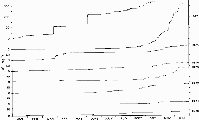 |
Figure 1. Annual seismic strain release in the Myrdalsjökull area, February 1970 through September 1977. From Skjálftabref (published by the Icelandic Meteorological Office, no. 26, October 1977. Courtesy of Ragnar Stefánsson. |
Information Contacts: R. Stefánsson, Icelandic Meteorological Office.
Tremor in mid-July followed by a jökulhlaup and ice cauldron formation
In the early morning of 18 July, a small jökulhlaup (sudden glacier-outburst flood) lasting less than 24 hours, occurred in "Jökulsá á Sólheimasandi," one of the rivers draining from the Mýrdalsjökull icecap (figure 2) towards the S. Inspection of the icecap revealed that a new ice cauldron, ~2 km wide, and 50 m deep, had formed just above the origin of the Sólheimajökull outlet glacier. The jökulhlaup was preceded on 17 July by a 20-minute-long burst of modest volcanic tremor (reported by P. Einarsson). Intrusion of magma at a low level within the subglacial Katla volcano or even a small subglacial eruption may have occurred, possibly associated with pulse of CO2 which could have caused boiling in geothermal areas under the icecap.
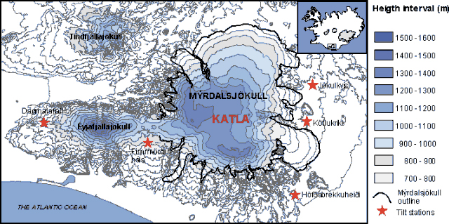 |
Figure 2. Topographic map of the Mýrdalsjökull icecap over Katla volcano showing tilt stations. Courtesy of the Nordisk Vulkvanologisk Institut. |
From 18 July until mid-August, ten new ice cauldrons formed along the W, S, and E borders of the Mýrdalsjökull caldera (figure 3), signifying increased geothermal activity along a large part of the caldera rim. Changes on the icecap surface have been reported for some of the earlier eruptions of Katla, and the current activity could be a possible long-term precursor to a new eruption. A flight over the area on 9 September by Reynir Ragnarsson at Vík, revealed that the ice cauldrons did not develop much after mid-August.
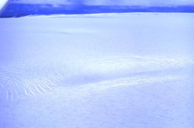 |
Figure 3. One of the new ice cauldrons on Mýrdalsjökull, July-August 1999. Photo by Freysteinn Sigmundsson. |
Information Contacts: Rósa Ólafsdóttir, Guðrún Sverrisdóttir, Freysteinn Sigmundsson, Erik Sturkell, and Níels Óskarsson, Nordisk Vulkvanologisk Institut, Grenásvegur 50, 108 Reyjavík, Iceland (URL: http://nordvulk.hi.is); Helgi Björnsson, Páll Einarsson, and Magnús Tumi Guðmundsson, Science Institute, University of Iceland, Dunhaga 3, 107 Reykjavík, Iceland (URL: http://www.raunvis.hi.is/); Ármann Höskuldsson, South Iceland Institute of Natural History, Strandvegur 50, 900 Vestmannaeyjar, Iceland (URL: https://www.nattsud.is/).
Jökulhlaup and elevated seismicity in 2011; filming sparks eruption fears
Microseismicity preceded and accompanied a jökulhlaup (a glacier-outburst flood) on 9 July 2011, as reported by the Iceland Met Office (IMO). The jökulhlaup escaped from under Mýrdalsjökull, the glacier that rests above Iceland's Katla volcano, its 10 x 14 km caldera, and environs (figure 4). IMO reported that microseismicity was registered near several ice cauldrons in the caldera for a few weeks prior to the event (figure 5). Peak harmonic tremor on 8 July coincided with rising water levels and increased water conductivity, as measured by the main flood gauge (figure 6; gauge is at red triangle on figure 4).
|
Figure 4. A map of road closures and restricted areas of Mýrdalsjökull glacier resulting from the 9 July 2011 jökulhlaup at Katla (see key, lower left). The town of Vík is shown near the bottom (in black), and the main road through the area is shown in red; the trace of Katla caldera is shown in black and labeled. The main flood gauge was on the bridge across the Múlakvísl river; both were destroyed in the jökulhlaup event (red triangle). Inset shows the geographic location of Katla and Mýrdalsjökull in the S of Iceland. Restricted areas map modified from ágúst Gunnar Gylfason of the National Commissioner of the Icelandic Police-Department of Civil Protection and Emergency Management; index map modified from Ginkgo Maps. |
|
Figure 5. Map (top) and plot (bottom) of the seismicity recorded during 8-9 July 2011 at Katla. Colors indicate the timing of epicenters and their respective plotted magnitudes, recorded as late as 2250 on 9 July 2011, according to the scheme shown below the map. Black triangles indicate seismic monitoring stations. Courtesy of Iceland Met Office (IMO). |
|
Figure 6. Running plots of (a) water level, (b) water temperature, and (c) water conductivity at the main flood gauge of the Múlakvísl river during 3-9 July 2011. The plots show rising water level and conductivity that were coincident with peak harmonic tremor. The plots stop abruptly (red vertical line) when the gauge was destroyed along with the bridge crossing the Múlakvísl river. Courtesy of Iceland Met Office (IMO). |
IMO reported that, on the same day, the main flood gauge was damaged when flood waters reached the instrument near midnight; another station, normally not in the water, started recording rising water around 0400 on 9 July, and the water level there rose 5 m within 5 minutes (figure 7). When the flood reached the main road approximately one hour later, the main bridge over the Múlakvísl river was destroyed and the road was closed (red triangle, figure 41).
|
Figure 7. A running plot of water level at the second flood gauge (normally not submerged). The plot shows a significant rise in water level (5 m within 5 minutes). Courtesy of Iceland Met Office (IMO). |
According to the news source Morgunblaðið, 200 people were safely evacuated, and allowed to return to their homes by that afternoon. Morgunblaðið reported that analysis of the flood waters indicated that the flood was caused by geothermal water, but that a sub-glacial eruption at Katla could not be ruled out. IMO stated that the harmonic tremor declined on 9 July, following the jökulhlaup event. After observational flights, new cracks and cauldrons were reported in the ice of Mýrdalsjökull glacier (figure 8).
|
Figure 8. Cracking and subsidence of the Mýrdalsjökull glacier around an ice cauldron above the Katla caldera. Widespread gray tephra deposited on the ice surface is due to the 2010 Eyjafjallajökull eruption (BGVN 35:03, 35:04). Courtesy of the Icelandic Coast Guard. |
By 16 July, the National Commissioner of Icelandic Police in the Department of Civil Protection and Emergency Management reported that a new bridge had been built to replace the bridge destroyed in the jökulhlaup (figure 9).
|
Figure 9. Photograph of the remains of the bridge crossing of the Múlakvísl river, destroyed in the jökulhlaup event on 9 July 2011. The new bridge, constructed by the 16 July 2011, can be seen in the background. Courtesy of John A. Stevenson. |
August-December seismicity. IMO reported increased seismicity under Mýrdalsjökull in October (figure 10). They reported that 512 earthquakes occurred, with ~ 380 originating within the Katla caldera; a large portion (nearly 100) of those 512 earthquakes occurred on one day near the beginning of October (figure 11). The largest reported earthquake was M 4, with seven being larger than M 3. On 8 November, an M 3.2 earthquake that originated in the S most part of the caldera was felt by residents in the town of Vík.
Overall, following the July 2011 jökulhlaup event, seismicity has increased above background levels of the past year. The seismic peak is noticeable with respect to the number of earthquakes, their largest magnitudes, and the clustering under Katla (figures 10 and 11). The largest earthquakes were as large, or slightly larger, than the other earthquakes of M 3 or greater in earlier episodes of unrest (i.e., 1999 and 2002-2004, figure 10). The bulk of the 2011 seismic increase occurred over a shallow depth range (within 4 km of the surface, figure 12).
|
Figure 10. Plots of seismicity (greater than M 0.6) at Katla since 1999, showing the October 2011 seismicity in comparison with past episodes of non-eruptive unrest, such as in 1999 (sub-glacial eruption is uncertain in the GVP database) and 2002-2004. Plots (from the top) show: the monthly number of earthquakes (log scale); the magnitudes of earthquakes; cumulative number of earthquakes (red) and cumulative seismic moment (blue); and the focal depths of the located earthquakes. Courtesy of Iceland Met Office (IMO). |
|
Figure 11. Seismic events (stronger than M 0.5) per day at Katla during December 2010-December 2011. Raw data is shown in blue, the 5 day moving average is shown in red, and events stronger than M 3.0 are indicated by gold stars. These trends highlight the increased seismicity of August-December 2011. Courtesy of the University of Edinburgh School of Geosciences. |
|
Figure 12. Cumulative number of seismic events (stronger than M 0.5) at Katla since 23 November 2010. All events are shown in yellow, and events originating at depths greater than 4 and 10 km are shown in orange and red, respectively. During the August-December 2011 increase in seismicity, the majority of the recorded events originated from shallow depths (less than 4 km). Courtesy of the University of Edinburgh School of Geosciences. |
Television filming sparks eruption fears. The Iceland Review reported that, in the early morning of 9 December, the Icelandic emergency hotline received calls from residents reporting bright lights on the slopes of Mýrdalsjökull. Callers feared that an eruption had started at Katla. The bright lights had also been noticed on a webcam by observers in Norway, who also enquired if there was an eruption. When the glacial slopes were inspected to find the cause of the lights, it was discovered that they were from film crews for the HBO series "Game of Thrones", who were filming in the early morning to capture the desired light conditions.
Information Contacts: Einar Kjartansson, Iceland Met Office (IMO), Bústaðavegi 9, 150 Reykjavík, Iceland (URL: http://en.vedur.is/); National Commissioner of the Icelandic Police-Department of Civil Protection and Emergency Management, Skúlagata 21, 101 Reykjavík, Iceland (URL: http://www.almannavarnir.is/); Ginkgo Maps (URL: http://ginkgomaps.com/); Morgunblaðið, Hádegismóum 2, 110 Reykjavík, Iceland (URL: http://mbl.is/); Icelandic Coast Guard, Skógarhlíð 14, 105 Reykjavík, Iceland (URL: http://www.lhg.is/); John A. Stevenson (URL: http://all-geo.org/volcan01010/); The University of Edinburgh School of Geosciences (URL: http://www.ed.ac.uk/schools-departments/geosciences); The Iceland Review, Borgartúni 23, 105 Reykjavík, Iceland (URL: http://www.icelandreview.com/).
|
|
||||||||||||||||||||||||||||
There is data available for 128 confirmed eruptive periods.
[ 1999 Jul 17 (?) - 1999 Aug 15 ± 5 days ] Uncertain Eruption
| Episode 1 | Eruption (Explosive / Effusive) | W, S, and E margins of caldera | |||||||||||||||||||||||
|---|---|---|---|---|---|---|---|---|---|---|---|---|---|---|---|---|---|---|---|---|---|---|---|---|
| 1999 Jul 17 (?) - 1999 Aug 15 ± 5 days | Evidence from Unknown | |||||||||||||||||||||||
|
List of 3 Events for Episode 1 at W, S, and E margins of caldera
|
||||||||||||||||||||||||
[ 1955 Jun 25 ] Uncertain Eruption
| Episode 1 | Eruption (Explosive / Effusive) | East side of caldera | ||||||||||||||||||
|---|---|---|---|---|---|---|---|---|---|---|---|---|---|---|---|---|---|---|---|
| 1955 Jun 25 - Unknown | Evidence from Unknown | ||||||||||||||||||
|
List of 2 Events for Episode 1 at East side of caldera
|
|||||||||||||||||||
1918 Oct 12 - 1918 Nov 4 Confirmed Eruption (Explosive / Effusive) VEI: 4
| Episode 1 | Eruption (Explosive / Effusive) | South side of caldera, K-1918 | ||||||||||||||||||||||||||||||||||||||
|---|---|---|---|---|---|---|---|---|---|---|---|---|---|---|---|---|---|---|---|---|---|---|---|---|---|---|---|---|---|---|---|---|---|---|---|---|---|---|---|
| 1918 Oct 12 - 1918 Nov 4 | Evidence from Observations: Reported | ||||||||||||||||||||||||||||||||||||||
|
List of 6 Events for Episode 1 at South side of caldera, K-1918
|
|||||||||||||||||||||||||||||||||||||||
1860 May 8 - 1860 May 27 Confirmed Eruption (Explosive / Effusive) VEI: 4
| Episode 1 | Eruption (Explosive / Effusive) | ||||||||||||||||||||||||||||||||||
|---|---|---|---|---|---|---|---|---|---|---|---|---|---|---|---|---|---|---|---|---|---|---|---|---|---|---|---|---|---|---|---|---|---|---|
| 1860 May 8 - 1860 May 27 | Evidence from Observations: Reported | |||||||||||||||||||||||||||||||||
|
List of 5 Events for Episode 1
|
||||||||||||||||||||||||||||||||||
1823 Jun 26 - 1823 Jul 23 Confirmed Eruption (Explosive / Effusive) VEI: 3 (?)
| Episode 1 | Eruption (Explosive / Effusive) | Arcuate fissure in south part of caldera | |||||||||||||||||||||||||||||||||
|---|---|---|---|---|---|---|---|---|---|---|---|---|---|---|---|---|---|---|---|---|---|---|---|---|---|---|---|---|---|---|---|---|---|---|
| 1823 Jun 26 - 1823 Jul 23 | Evidence from Observations: Reported | |||||||||||||||||||||||||||||||||
|
List of 5 Events for Episode 1 at Arcuate fissure in south part of caldera
|
||||||||||||||||||||||||||||||||||
1755 Oct 17 - 1756 Feb 13 Confirmed Eruption (Explosive / Effusive) VEI: 5 (?)
| Episode 1 | Eruption (Explosive / Effusive) | E-W fissure in center of caldera | |||||||||||||||||||||||||||||||||||||||||||||||||||||
|---|---|---|---|---|---|---|---|---|---|---|---|---|---|---|---|---|---|---|---|---|---|---|---|---|---|---|---|---|---|---|---|---|---|---|---|---|---|---|---|---|---|---|---|---|---|---|---|---|---|---|---|---|---|---|
| 1755 Oct 17 - 1756 Feb 13 | Evidence from Observations: Reported | |||||||||||||||||||||||||||||||||||||||||||||||||||||
|
List of 9 Events for Episode 1 at E-W fissure in center of caldera
|
||||||||||||||||||||||||||||||||||||||||||||||||||||||
1721 May 11 - 1721 Oct 15 ± 45 days Confirmed Eruption (Explosive / Effusive) VEI: 5 (?)
| Episode 1 | Eruption (Explosive / Effusive) | |||||||||||||||||||||||||||||||||||||||
|---|---|---|---|---|---|---|---|---|---|---|---|---|---|---|---|---|---|---|---|---|---|---|---|---|---|---|---|---|---|---|---|---|---|---|---|---|---|---|---|
| 1721 May 11 - 1721 Oct 15 ± 45 days | Evidence from Observations: Reported | ||||||||||||||||||||||||||||||||||||||
|
List of 6 Events for Episode 1
|
|||||||||||||||||||||||||||||||||||||||
1660 Nov 3 - 1661 Confirmed Eruption (Explosive / Effusive) VEI: 4
| Episode 1 | Eruption (Explosive / Effusive) | |||||||||||||||||||||||||||||||||||||||
|---|---|---|---|---|---|---|---|---|---|---|---|---|---|---|---|---|---|---|---|---|---|---|---|---|---|---|---|---|---|---|---|---|---|---|---|---|---|---|---|
| 1660 Nov 3 - 1661 | Evidence from Observations: Reported | ||||||||||||||||||||||||||||||||||||||
|
List of 6 Events for Episode 1
|
|||||||||||||||||||||||||||||||||||||||
1625 Sep 2 - 1625 Sep 14 Confirmed Eruption (Explosive / Effusive) VEI: 5
| Episode 1 | Eruption (Explosive / Effusive) | ||||||||||||||||||||||||||||||||||||||||||||
|---|---|---|---|---|---|---|---|---|---|---|---|---|---|---|---|---|---|---|---|---|---|---|---|---|---|---|---|---|---|---|---|---|---|---|---|---|---|---|---|---|---|---|---|---|
| 1625 Sep 2 - 1625 Sep 14 | Evidence from Observations: Reported | |||||||||||||||||||||||||||||||||||||||||||
|
List of 7 Events for Episode 1
|
||||||||||||||||||||||||||||||||||||||||||||
1612 Oct 12 Confirmed Eruption (Explosive / Effusive) VEI: 4
| Episode 1 | Eruption (Explosive / Effusive) | |||||||||||||||||||||||||||||
|---|---|---|---|---|---|---|---|---|---|---|---|---|---|---|---|---|---|---|---|---|---|---|---|---|---|---|---|---|---|
| 1612 Oct 12 - Unknown | Evidence from Observations: Reported | ||||||||||||||||||||||||||||
|
List of 4 Events for Episode 1
|
|||||||||||||||||||||||||||||
1580 Aug 11 Confirmed Eruption (Explosive / Effusive) VEI: 4
| Episode 1 | Eruption (Explosive / Effusive) | ||||||||||||||||||||||||||||||||||
|---|---|---|---|---|---|---|---|---|---|---|---|---|---|---|---|---|---|---|---|---|---|---|---|---|---|---|---|---|---|---|---|---|---|---|
| 1580 Aug 11 - Unknown | Evidence from Observations: Reported | |||||||||||||||||||||||||||||||||
|
List of 5 Events for Episode 1
|
||||||||||||||||||||||||||||||||||
1550 (?) Confirmed Eruption (Explosive / Effusive) VEI: 4
| Episode 1 | Eruption (Explosive / Effusive) | |||||||||||||||||||||||||||||
|---|---|---|---|---|---|---|---|---|---|---|---|---|---|---|---|---|---|---|---|---|---|---|---|---|---|---|---|---|---|
| 1550 (?) - Unknown | Evidence from Correlation: Tephrochronology | ||||||||||||||||||||||||||||
|
List of 4 Events for Episode 1
|
|||||||||||||||||||||||||||||
1500 (?) Confirmed Eruption (Explosive / Effusive) VEI: 4
| Episode 1 | Eruption (Explosive / Effusive) | |||||||||||||||||||||||||||||||||||||||
|---|---|---|---|---|---|---|---|---|---|---|---|---|---|---|---|---|---|---|---|---|---|---|---|---|---|---|---|---|---|---|---|---|---|---|---|---|---|---|---|
| 1500 (?) - Unknown | Evidence from Correlation: Tephrochronology | ||||||||||||||||||||||||||||||||||||||
|
List of 6 Events for Episode 1
|
|||||||||||||||||||||||||||||||||||||||
1450 ± 50 years Confirmed Eruption (Explosive / Effusive)
| Episode 1 | Eruption (Explosive / Effusive) | ||||||||||||||||||||||||
|---|---|---|---|---|---|---|---|---|---|---|---|---|---|---|---|---|---|---|---|---|---|---|---|---|
| 1450 ± 50 years - Unknown | Evidence from Correlation: Tephrochronology | |||||||||||||||||||||||
|
List of 3 Events for Episode 1
|
||||||||||||||||||||||||
1440 Confirmed Eruption (Explosive / Effusive) VEI: 4
| Episode 1 | Eruption (Explosive / Effusive) | |||||||||||||||||||||||||||||
|---|---|---|---|---|---|---|---|---|---|---|---|---|---|---|---|---|---|---|---|---|---|---|---|---|---|---|---|---|---|
| 1440 - Unknown | Evidence from Observations: Reported | ||||||||||||||||||||||||||||
|
List of 4 Events for Episode 1
|
|||||||||||||||||||||||||||||
1416 Confirmed Eruption (Explosive / Effusive) VEI: 4 (?)
| Episode 1 | Eruption (Explosive / Effusive) | |||||||||||||||||||||||||||||
|---|---|---|---|---|---|---|---|---|---|---|---|---|---|---|---|---|---|---|---|---|---|---|---|---|---|---|---|---|---|
| 1416 - Unknown | Evidence from Observations: Reported | ||||||||||||||||||||||||||||
|
List of 4 Events for Episode 1
|
|||||||||||||||||||||||||||||
1357 ± 3 years Confirmed Eruption (Explosive / Effusive) VEI: 4
| Episode 1 | Eruption (Explosive / Effusive) | SW of Kotlugja | ||||||||||||||||||||||||||||||||||||||||||||||||
|---|---|---|---|---|---|---|---|---|---|---|---|---|---|---|---|---|---|---|---|---|---|---|---|---|---|---|---|---|---|---|---|---|---|---|---|---|---|---|---|---|---|---|---|---|---|---|---|---|---|
| 1357 ± 3 years - Unknown | Evidence from Observations: Reported | ||||||||||||||||||||||||||||||||||||||||||||||||
|
List of 8 Events for Episode 1 at SW of Kotlugja
|
|||||||||||||||||||||||||||||||||||||||||||||||||
1311 Jan 18 Confirmed Eruption (Explosive / Effusive)
| Episode 1 | Eruption (Explosive / Effusive) | |||||||||||||||||||||||||||||||||||||||
|---|---|---|---|---|---|---|---|---|---|---|---|---|---|---|---|---|---|---|---|---|---|---|---|---|---|---|---|---|---|---|---|---|---|---|---|---|---|---|---|
| 1311 Jan 18 - Unknown | Evidence from Observations: Reported | ||||||||||||||||||||||||||||||||||||||
|
List of 6 Events for Episode 1
|
|||||||||||||||||||||||||||||||||||||||
1262 Confirmed Eruption (Explosive / Effusive) VEI: 5
| Episode 1 | Eruption (Explosive / Effusive) | |||||||||||||||||||||||||||||||||||||||
|---|---|---|---|---|---|---|---|---|---|---|---|---|---|---|---|---|---|---|---|---|---|---|---|---|---|---|---|---|---|---|---|---|---|---|---|---|---|---|---|
| 1262 - Unknown | Evidence from Observations: Reported | ||||||||||||||||||||||||||||||||||||||
|
List of 6 Events for Episode 1
|
|||||||||||||||||||||||||||||||||||||||
1245 Confirmed Eruption (Explosive / Effusive) VEI: 4
| Episode 1 | Eruption (Explosive / Effusive) | ||||||||||||||||||||||||||||||||||
|---|---|---|---|---|---|---|---|---|---|---|---|---|---|---|---|---|---|---|---|---|---|---|---|---|---|---|---|---|---|---|---|---|---|---|
| 1245 - Unknown | Evidence from Observations: Reported | |||||||||||||||||||||||||||||||||
|
List of 5 Events for Episode 1
|
||||||||||||||||||||||||||||||||||
1210 (?) Confirmed Eruption (Explosive / Effusive) VEI: 4
| Episode 1 | Eruption (Explosive / Effusive) | ||||||||||||||||||||||||
|---|---|---|---|---|---|---|---|---|---|---|---|---|---|---|---|---|---|---|---|---|---|---|---|---|
| 1210 (?) - Unknown | Evidence from Correlation: Tephrochronology | |||||||||||||||||||||||
|
List of 3 Events for Episode 1
|
||||||||||||||||||||||||
1177 ± 2 years Confirmed Eruption (Explosive / Effusive) VEI: 3
| Episode 1 | Eruption (Explosive / Effusive) | ||||||||||||||||||||||||||||||||||
|---|---|---|---|---|---|---|---|---|---|---|---|---|---|---|---|---|---|---|---|---|---|---|---|---|---|---|---|---|---|---|---|---|---|---|
| 1177 ± 2 years - Unknown | Evidence from Observations: Reported | |||||||||||||||||||||||||||||||||
|
List of 5 Events for Episode 1
|
||||||||||||||||||||||||||||||||||
1150 ± 50 years Confirmed Eruption (Explosive / Effusive)
| Episode 1 | Eruption (Explosive / Effusive) | ||||||||||||||||||||||||
|---|---|---|---|---|---|---|---|---|---|---|---|---|---|---|---|---|---|---|---|---|---|---|---|---|
| 1150 ± 50 years - Unknown | Evidence from Correlation: Tephrochronology | |||||||||||||||||||||||
|
List of 3 Events for Episode 1
|
||||||||||||||||||||||||
[ 1000 (?) ] Discredited Eruption
0960 (?) Confirmed Eruption (Explosive / Effusive) VEI: 3
| Episode 1 | Eruption (Explosive / Effusive) | ||||||||||||||||||||||||
|---|---|---|---|---|---|---|---|---|---|---|---|---|---|---|---|---|---|---|---|---|---|---|---|---|
| 0960 (?) - Unknown | Evidence from Correlation: Tephrochronology | |||||||||||||||||||||||
|
List of 3 Events for Episode 1
|
||||||||||||||||||||||||
0950 (?) Confirmed Eruption (Explosive / Effusive)
| Episode 1 | Eruption (Explosive / Effusive) | |||||||||||||||||||||||||||||
|---|---|---|---|---|---|---|---|---|---|---|---|---|---|---|---|---|---|---|---|---|---|---|---|---|---|---|---|---|---|
| 0950 (?) - Unknown | Evidence from Correlation: Tephrochronology | ||||||||||||||||||||||||||||
|
List of 4 Events for Episode 1
|
|||||||||||||||||||||||||||||
0934 ± 2 years - 0940 (?) Confirmed Eruption (Explosive / Effusive) VEI: 4 (?)
| Episode 1 | Eruption (Explosive / Effusive) | Eldgjá fissure system (NE flank) | ||||||||||||||||||||||||||||||||||||||||||||||||||||||||||
|---|---|---|---|---|---|---|---|---|---|---|---|---|---|---|---|---|---|---|---|---|---|---|---|---|---|---|---|---|---|---|---|---|---|---|---|---|---|---|---|---|---|---|---|---|---|---|---|---|---|---|---|---|---|---|---|---|---|---|---|
| 0934 ± 2 years - 0940 (?) | Evidence from Sidereal: Ice Core | ||||||||||||||||||||||||||||||||||||||||||||||||||||||||||
| This fissure eruption, the "Eldgjá Fires", produced one of the largest lava flows recorded, comparable to the volume of the nearby 1783 Laki (Skaftar) lava flow. The lava flow spread out in a broad lobe on the coastal plain, reaching the sea at Mydalssandur. The eruption produced an estimated 18 km3 of basaltic lava and 1.3 km3 of tephra (Thordarson et al., 2001). Including the amount deposited at sea, Larsen (2000) estimated a volume in excess of 4 km3. Conflicting descriptions of the estates of early settlers suggests that the eruption affected farms in the area (Larsen, 1979). Jonsson (1987) considered the Landbrotshraun portion of the flow to be much older; however, Larsen (2000) and Thordarson et al. (2001) considered this lobe to part of this eruption. The eruption was considered to have lasted until 940 CE by Oladottir et al. (2008). | |||||||||||||||||||||||||||||||||||||||||||||||||||||||||||
|
List of 10 Events for Episode 1 at Eldgjá fissure system (NE flank)
|
|||||||||||||||||||||||||||||||||||||||||||||||||||||||||||
0920 Confirmed Eruption (Explosive / Effusive) VEI: 4
| Episode 1 | Eruption (Explosive / Effusive) | |||||||||||||||||||||||||||||
|---|---|---|---|---|---|---|---|---|---|---|---|---|---|---|---|---|---|---|---|---|---|---|---|---|---|---|---|---|---|
| 0920 - Unknown | Evidence from Observations: Reported | ||||||||||||||||||||||||||||
|
List of 4 Events for Episode 1
|
|||||||||||||||||||||||||||||
[ 0904 (?) ] Uncertain Eruption
| Episode 1 | Eruption (Explosive / Effusive) | ||||||||||||||
|---|---|---|---|---|---|---|---|---|---|---|---|---|---|---|
| 0904 (?) - Unknown | Evidence from Unknown | |||||||||||||
|
List of 1 Events for Episode 1
|
||||||||||||||
0820 (?) Confirmed Eruption (Explosive / Effusive)
| Episode 1 | Eruption (Explosive / Effusive) | |||||||||||||||||||
|---|---|---|---|---|---|---|---|---|---|---|---|---|---|---|---|---|---|---|---|
| 0820 (?) - Unknown | Evidence from Correlation: Tephrochronology | ||||||||||||||||||
|
List of 2 Events for Episode 1
|
|||||||||||||||||||
0780 (?) Confirmed Eruption (Explosive / Effusive)
| Episode 1 | Eruption (Explosive / Effusive) | |||||||||||||||||||
|---|---|---|---|---|---|---|---|---|---|---|---|---|---|---|---|---|---|---|---|
| 0780 (?) - Unknown | Evidence from Correlation: Tephrochronology | ||||||||||||||||||
|
List of 2 Events for Episode 1
|
|||||||||||||||||||
0680 (?) Confirmed Eruption (Explosive / Effusive)
| Episode 1 | Eruption (Explosive / Effusive) | |||||||||||||||||||
|---|---|---|---|---|---|---|---|---|---|---|---|---|---|---|---|---|---|---|---|
| 0680 (?) - Unknown | Evidence from Correlation: Tephrochronology | ||||||||||||||||||
|
List of 2 Events for Episode 1
|
|||||||||||||||||||
0610 (?) Confirmed Eruption (Explosive / Effusive)
| Episode 1 | Eruption (Explosive / Effusive) | |||||||||||||||||||
|---|---|---|---|---|---|---|---|---|---|---|---|---|---|---|---|---|---|---|---|
| 0610 (?) - Unknown | Evidence from Correlation: Tephrochronology | ||||||||||||||||||
|
List of 2 Events for Episode 1
|
|||||||||||||||||||
0590 (?) Confirmed Eruption (Explosive / Effusive)
| Episode 1 | Eruption (Explosive / Effusive) | ||||||||||||||
|---|---|---|---|---|---|---|---|---|---|---|---|---|---|---|
| 0590 (?) - Unknown | Evidence from Correlation: Tephrochronology | |||||||||||||
|
List of 1 Events for Episode 1
|
||||||||||||||
0540 (?) Confirmed Eruption (Explosive / Effusive)
| Episode 1 | Eruption (Explosive / Effusive) | |||||||||||||||||||
|---|---|---|---|---|---|---|---|---|---|---|---|---|---|---|---|---|---|---|---|
| 0540 (?) - Unknown | Evidence from Correlation: Tephrochronology | ||||||||||||||||||
|
List of 2 Events for Episode 1
|
|||||||||||||||||||
0500 (?) Confirmed Eruption (Explosive / Effusive)
| Episode 1 | Eruption (Explosive / Effusive) | |||||||||||||||||||
|---|---|---|---|---|---|---|---|---|---|---|---|---|---|---|---|---|---|---|---|
| 0500 (?) - Unknown | Evidence from Correlation: Tephrochronology | ||||||||||||||||||
|
List of 2 Events for Episode 1
|
|||||||||||||||||||
0400 (?) Confirmed Eruption (Explosive / Effusive)
| Episode 1 | Eruption (Explosive / Effusive) | |||||||||||||||||||
|---|---|---|---|---|---|---|---|---|---|---|---|---|---|---|---|---|---|---|---|
| 0400 (?) - Unknown | Evidence from Correlation: Tephrochronology | ||||||||||||||||||
|
List of 2 Events for Episode 1
|
|||||||||||||||||||
0290 (?) Confirmed Eruption (Explosive / Effusive)
| Episode 1 | Eruption (Explosive / Effusive) | |||||||||||||||||||
|---|---|---|---|---|---|---|---|---|---|---|---|---|---|---|---|---|---|---|---|
| 0290 (?) - Unknown | Evidence from Correlation: Tephrochronology | ||||||||||||||||||
|
List of 2 Events for Episode 1
|
|||||||||||||||||||
0270 ± 12 years Confirmed Eruption (Explosive / Effusive) VEI: 3
| Episode 1 | Eruption (Explosive / Effusive) | Tephra layer YN | ||||||||||||||||||||||||||||
|---|---|---|---|---|---|---|---|---|---|---|---|---|---|---|---|---|---|---|---|---|---|---|---|---|---|---|---|---|---|
| 0270 ± 12 years - Unknown | Evidence from Isotopic: 14C (uncalibrated) | ||||||||||||||||||||||||||||
|
List of 4 Events for Episode 1 at Tephra layer YN
|
|||||||||||||||||||||||||||||
0260 (?) Confirmed Eruption (Explosive / Effusive)
| Episode 1 | Eruption (Explosive / Effusive) | |||||||||||||||||||
|---|---|---|---|---|---|---|---|---|---|---|---|---|---|---|---|---|---|---|---|
| 0260 (?) - Unknown | Evidence from Correlation: Tephrochronology | ||||||||||||||||||
|
List of 2 Events for Episode 1
|
|||||||||||||||||||
0200 (?) Confirmed Eruption (Explosive / Effusive)
| Episode 1 | Eruption (Explosive / Effusive) | |||||||||||||||||||
|---|---|---|---|---|---|---|---|---|---|---|---|---|---|---|---|---|---|---|---|
| 0200 (?) - Unknown | Evidence from Correlation: Tephrochronology | ||||||||||||||||||
|
List of 2 Events for Episode 1
|
|||||||||||||||||||
0130 (?) Confirmed Eruption (Explosive / Effusive)
| Episode 1 | Eruption (Explosive / Effusive) | |||||||||||||||||||
|---|---|---|---|---|---|---|---|---|---|---|---|---|---|---|---|---|---|---|---|
| 0130 (?) - Unknown | Evidence from Correlation: Tephrochronology | ||||||||||||||||||
|
List of 2 Events for Episode 1
|
|||||||||||||||||||
0030 (?) Confirmed Eruption (Explosive / Effusive)
| Episode 1 | Eruption (Explosive / Effusive) | |||||||||||||||||||
|---|---|---|---|---|---|---|---|---|---|---|---|---|---|---|---|---|---|---|---|
| 0030 (?) - Unknown | Evidence from Correlation: Tephrochronology | ||||||||||||||||||
|
List of 2 Events for Episode 1
|
|||||||||||||||||||
0080 BCE (?) Confirmed Eruption (Explosive / Effusive)
| Episode 1 | Eruption (Explosive / Effusive) | |||||||||||||||||||
|---|---|---|---|---|---|---|---|---|---|---|---|---|---|---|---|---|---|---|---|
| 0080 BCE (?) - Unknown | Evidence from Correlation: Tephrochronology | ||||||||||||||||||
|
List of 2 Events for Episode 1
|
|||||||||||||||||||
0250 BCE (?) Confirmed Eruption (Explosive / Effusive)
| Episode 1 | Eruption (Explosive / Effusive) | |||||||||||||||||||
|---|---|---|---|---|---|---|---|---|---|---|---|---|---|---|---|---|---|---|---|
| 0250 BCE (?) - Unknown | Evidence from Correlation: Tephrochronology | ||||||||||||||||||
|
List of 2 Events for Episode 1
|
|||||||||||||||||||
0370 BCE (?) Confirmed Eruption (Explosive / Effusive)
| Episode 1 | Eruption (Explosive / Effusive) | |||||||||||||||||||
|---|---|---|---|---|---|---|---|---|---|---|---|---|---|---|---|---|---|---|---|
| 0370 BCE (?) - Unknown | Evidence from Correlation: Tephrochronology | ||||||||||||||||||
|
List of 2 Events for Episode 1
|
|||||||||||||||||||
0430 BCE (?) Confirmed Eruption (Explosive / Effusive)
| Episode 1 | Eruption (Explosive / Effusive) | |||||||||||||||||||
|---|---|---|---|---|---|---|---|---|---|---|---|---|---|---|---|---|---|---|---|
| 0430 BCE (?) - Unknown | Evidence from Correlation: Tephrochronology | ||||||||||||||||||
|
List of 2 Events for Episode 1
|
|||||||||||||||||||
0530 BCE (?) Confirmed Eruption (Explosive / Effusive)
| Episode 1 | Eruption (Explosive / Effusive) | |||||||||||||||||||
|---|---|---|---|---|---|---|---|---|---|---|---|---|---|---|---|---|---|---|---|
| 0530 BCE (?) - Unknown | Evidence from Correlation: Tephrochronology | ||||||||||||||||||
|
List of 2 Events for Episode 1
|
|||||||||||||||||||
0550 BCE (?) Confirmed Eruption (Explosive / Effusive)
| Episode 1 | Eruption (Explosive / Effusive) | |||||||||||||||||||
|---|---|---|---|---|---|---|---|---|---|---|---|---|---|---|---|---|---|---|---|
| 0550 BCE (?) - Unknown | Evidence from Correlation: Tephrochronology | ||||||||||||||||||
|
List of 2 Events for Episode 1
|
|||||||||||||||||||
0560 BCE (?) Confirmed Eruption (Explosive / Effusive)
| Episode 1 | Eruption (Explosive / Effusive) | |||||||||||||||||||
|---|---|---|---|---|---|---|---|---|---|---|---|---|---|---|---|---|---|---|---|
| 0560 BCE (?) - Unknown | Evidence from Correlation: Tephrochronology | ||||||||||||||||||
|
List of 2 Events for Episode 1
|
|||||||||||||||||||
0600 BCE (?) Confirmed Eruption (Explosive / Effusive)
| Episode 1 | Eruption (Explosive / Effusive) | |||||||||||||||||||
|---|---|---|---|---|---|---|---|---|---|---|---|---|---|---|---|---|---|---|---|
| 0600 BCE (?) - Unknown | Evidence from Correlation: Tephrochronology | ||||||||||||||||||
|
List of 2 Events for Episode 1
|
|||||||||||||||||||
0650 BCE (?) Confirmed Eruption (Explosive / Effusive)
| Episode 1 | Eruption (Explosive / Effusive) | |||||||||||||||||||
|---|---|---|---|---|---|---|---|---|---|---|---|---|---|---|---|---|---|---|---|
| 0650 BCE (?) - Unknown | Evidence from Correlation: Tephrochronology | ||||||||||||||||||
|
List of 2 Events for Episode 1
|
|||||||||||||||||||
0700 BCE (?) Confirmed Eruption (Explosive / Effusive)
| Episode 1 | Eruption (Explosive / Effusive) | |||||||||||||||||||
|---|---|---|---|---|---|---|---|---|---|---|---|---|---|---|---|---|---|---|---|
| 0700 BCE (?) - Unknown | Evidence from Correlation: Tephrochronology | ||||||||||||||||||
|
List of 2 Events for Episode 1
|
|||||||||||||||||||
0740 BCE (?) Confirmed Eruption (Explosive / Effusive)
| Episode 1 | Eruption (Explosive / Effusive) | |||||||||||||||||||
|---|---|---|---|---|---|---|---|---|---|---|---|---|---|---|---|---|---|---|---|
| 0740 BCE (?) - Unknown | Evidence from Correlation: Tephrochronology | ||||||||||||||||||
|
List of 2 Events for Episode 1
|
|||||||||||||||||||
0780 BCE (?) Confirmed Eruption (Explosive / Effusive)
| Episode 1 | Eruption (Explosive / Effusive) | |||||||||||||||||||
|---|---|---|---|---|---|---|---|---|---|---|---|---|---|---|---|---|---|---|---|
| 0780 BCE (?) - Unknown | Evidence from Correlation: Tephrochronology | ||||||||||||||||||
|
List of 2 Events for Episode 1
|
|||||||||||||||||||
0850 BCE ± 50 years Confirmed Eruption (Explosive / Effusive) VEI: 4
| Episode 1 | Eruption (Explosive / Effusive) | Tephra layer UN | |||||||||||||||||||||||||||||||||
|---|---|---|---|---|---|---|---|---|---|---|---|---|---|---|---|---|---|---|---|---|---|---|---|---|---|---|---|---|---|---|---|---|---|---|
| 0850 BCE ± 50 years - Unknown | Evidence from Isotopic: 14C (calibrated) | |||||||||||||||||||||||||||||||||
|
List of 5 Events for Episode 1 at Tephra layer UN
|
||||||||||||||||||||||||||||||||||
0860 BCE (?) Confirmed Eruption (Explosive / Effusive)
| Episode 1 | Eruption (Explosive / Effusive) | |||||||||||||||||||
|---|---|---|---|---|---|---|---|---|---|---|---|---|---|---|---|---|---|---|---|
| 0860 BCE (?) - Unknown | Evidence from Correlation: Tephrochronology | ||||||||||||||||||
|
List of 2 Events for Episode 1
|
|||||||||||||||||||
0920 BCE (?) Confirmed Eruption (Explosive / Effusive)
| Episode 1 | Eruption (Explosive / Effusive) | |||||||||||||||||||
|---|---|---|---|---|---|---|---|---|---|---|---|---|---|---|---|---|---|---|---|
| 0920 BCE (?) - Unknown | Evidence from Correlation: Tephrochronology | ||||||||||||||||||
|
List of 2 Events for Episode 1
|
|||||||||||||||||||
0990 BCE (?) Confirmed Eruption (Explosive / Effusive)
| Episode 1 | Eruption (Explosive / Effusive) | |||||||||||||||||||
|---|---|---|---|---|---|---|---|---|---|---|---|---|---|---|---|---|---|---|---|
| 0990 BCE (?) - Unknown | Evidence from Correlation: Tephrochronology | ||||||||||||||||||
|
List of 2 Events for Episode 1
|
|||||||||||||||||||
1160 BCE (?) Confirmed Eruption (Explosive / Effusive)
| Episode 1 | Eruption (Explosive / Effusive) | |||||||||||||||||||
|---|---|---|---|---|---|---|---|---|---|---|---|---|---|---|---|---|---|---|---|
| 1160 BCE (?) - Unknown | Evidence from Correlation: Tephrochronology | ||||||||||||||||||
|
List of 2 Events for Episode 1
|
|||||||||||||||||||
1190 BCE (?) Confirmed Eruption (Explosive / Effusive)
| Episode 1 | Eruption (Explosive / Effusive) | |||||||||||||||||||
|---|---|---|---|---|---|---|---|---|---|---|---|---|---|---|---|---|---|---|---|
| 1190 BCE (?) - Unknown | Evidence from Correlation: Tephrochronology | ||||||||||||||||||
|
List of 2 Events for Episode 1
|
|||||||||||||||||||
1220 BCE ± 12 years Confirmed Eruption (Explosive / Effusive) VEI: 3
| Episode 1 | Eruption (Explosive / Effusive) | Tephra layer MN | ||||||||||||||||||||||||||||
|---|---|---|---|---|---|---|---|---|---|---|---|---|---|---|---|---|---|---|---|---|---|---|---|---|---|---|---|---|---|
| 1220 BCE ± 12 years - Unknown | Evidence from Isotopic: 14C (calibrated) | ||||||||||||||||||||||||||||
|
List of 4 Events for Episode 1 at Tephra layer MN
|
|||||||||||||||||||||||||||||
1280 BCE (?) Confirmed Eruption (Explosive / Effusive)
| Episode 1 | Eruption (Explosive / Effusive) | |||||||||||||||||||
|---|---|---|---|---|---|---|---|---|---|---|---|---|---|---|---|---|---|---|---|
| 1280 BCE (?) - Unknown | Evidence from Correlation: Tephrochronology | ||||||||||||||||||
|
List of 2 Events for Episode 1
|
|||||||||||||||||||
1290 BCE (?) Confirmed Eruption (Explosive / Effusive)
| Episode 1 | Eruption (Explosive / Effusive) | |||||||||||||||||||
|---|---|---|---|---|---|---|---|---|---|---|---|---|---|---|---|---|---|---|---|
| 1290 BCE (?) - Unknown | Evidence from Correlation: Tephrochronology | ||||||||||||||||||
|
List of 2 Events for Episode 1
|
|||||||||||||||||||
1440 BCE ± 40 years Confirmed Eruption (Explosive / Effusive) VEI: 4
| Episode 1 | Eruption (Explosive / Effusive) | Tephra layer LN | |||||||||||||||||||||||||||||||||
|---|---|---|---|---|---|---|---|---|---|---|---|---|---|---|---|---|---|---|---|---|---|---|---|---|---|---|---|---|---|---|---|---|---|---|
| 1440 BCE ± 40 years - Unknown | Evidence from Isotopic: 14C (calibrated) | |||||||||||||||||||||||||||||||||
|
List of 5 Events for Episode 1 at Tephra layer LN
|
||||||||||||||||||||||||||||||||||
1540 BCE (?) Confirmed Eruption (Explosive / Effusive)
| Episode 1 | Eruption (Explosive / Effusive) | |||||||||||||||||||
|---|---|---|---|---|---|---|---|---|---|---|---|---|---|---|---|---|---|---|---|
| 1540 BCE (?) - Unknown | Evidence from Correlation: Tephrochronology | ||||||||||||||||||
|
List of 2 Events for Episode 1
|
|||||||||||||||||||
1640 BCE (?) Confirmed Eruption (Explosive / Effusive)
| Episode 1 | Eruption (Explosive / Effusive) | |||||||||||||||||||
|---|---|---|---|---|---|---|---|---|---|---|---|---|---|---|---|---|---|---|---|
| 1640 BCE (?) - Unknown | Evidence from Correlation: Tephrochronology | ||||||||||||||||||
|
List of 2 Events for Episode 1
|
|||||||||||||||||||
1670 BCE (?) Confirmed Eruption (Explosive / Effusive)
| Episode 1 | Eruption (Explosive / Effusive) | |||||||||||||||||||
|---|---|---|---|---|---|---|---|---|---|---|---|---|---|---|---|---|---|---|---|
| 1670 BCE (?) - Unknown | Evidence from Correlation: Tephrochronology | ||||||||||||||||||
|
List of 2 Events for Episode 1
|
|||||||||||||||||||
1700 BCE (?) Confirmed Eruption (Explosive / Effusive)
| Episode 1 | Eruption (Explosive / Effusive) | |||||||||||||||||||
|---|---|---|---|---|---|---|---|---|---|---|---|---|---|---|---|---|---|---|---|
| 1700 BCE (?) - Unknown | Evidence from Correlation: Tephrochronology | ||||||||||||||||||
|
List of 2 Events for Episode 1
|
|||||||||||||||||||
1850 BCE (?) Confirmed Eruption (Explosive / Effusive)
| Episode 1 | Eruption (Explosive / Effusive) | |||||||||||||||||||
|---|---|---|---|---|---|---|---|---|---|---|---|---|---|---|---|---|---|---|---|
| 1850 BCE (?) - Unknown | Evidence from Correlation: Tephrochronology | ||||||||||||||||||
|
List of 2 Events for Episode 1
|
|||||||||||||||||||
1910 BCE (?) Confirmed Eruption (Explosive / Effusive)
| Episode 1 | Eruption (Explosive / Effusive) | |||||||||||||||||||
|---|---|---|---|---|---|---|---|---|---|---|---|---|---|---|---|---|---|---|---|
| 1910 BCE (?) - Unknown | Evidence from Correlation: Tephrochronology | ||||||||||||||||||
|
List of 2 Events for Episode 1
|
|||||||||||||||||||
1920 BCE (?) Confirmed Eruption (Explosive / Effusive) VEI: 4
| Episode 1 | Eruption (Explosive / Effusive) | Tephra layer N4 | |||||||||||||||||||||||||||||||||
|---|---|---|---|---|---|---|---|---|---|---|---|---|---|---|---|---|---|---|---|---|---|---|---|---|---|---|---|---|---|---|---|---|---|---|
| 1920 BCE (?) - Unknown | Evidence from Isotopic: 14C (calibrated) | |||||||||||||||||||||||||||||||||
|
List of 5 Events for Episode 1 at Tephra layer N4
|
||||||||||||||||||||||||||||||||||
1950 BCE (?) Confirmed Eruption (Explosive / Effusive)
| Episode 1 | Eruption (Explosive / Effusive) | |||||||||||||||||||
|---|---|---|---|---|---|---|---|---|---|---|---|---|---|---|---|---|---|---|---|
| 1950 BCE (?) - Unknown | Evidence from Correlation: Tephrochronology | ||||||||||||||||||
|
List of 2 Events for Episode 1
|
|||||||||||||||||||
2000 BCE (?) Confirmed Eruption (Explosive / Effusive)
| Episode 1 | Eruption (Explosive / Effusive) | |||||||||||||||||||
|---|---|---|---|---|---|---|---|---|---|---|---|---|---|---|---|---|---|---|---|
| 2000 BCE (?) - Unknown | Evidence from Correlation: Tephrochronology | ||||||||||||||||||
|
List of 2 Events for Episode 1
|
|||||||||||||||||||
2020 BCE (?) Confirmed Eruption (Explosive / Effusive)
| Episode 1 | Eruption (Explosive / Effusive) | |||||||||||||||||||
|---|---|---|---|---|---|---|---|---|---|---|---|---|---|---|---|---|---|---|---|
| 2020 BCE (?) - Unknown | Evidence from Correlation: Tephrochronology | ||||||||||||||||||
|
List of 2 Events for Episode 1
|
|||||||||||||||||||
2050 BCE (?) Confirmed Eruption (Explosive / Effusive)
| Episode 1 | Eruption (Explosive / Effusive) | |||||||||||||||||||
|---|---|---|---|---|---|---|---|---|---|---|---|---|---|---|---|---|---|---|---|
| 2050 BCE (?) - Unknown | Evidence from Correlation: Tephrochronology | ||||||||||||||||||
|
List of 2 Events for Episode 1
|
|||||||||||||||||||
2110 BCE (?) Confirmed Eruption (Explosive / Effusive)
| Episode 1 | Eruption (Explosive / Effusive) | |||||||||||||||||||
|---|---|---|---|---|---|---|---|---|---|---|---|---|---|---|---|---|---|---|---|
| 2110 BCE (?) - Unknown | Evidence from Correlation: Tephrochronology | ||||||||||||||||||
|
List of 2 Events for Episode 1
|
|||||||||||||||||||
2160 BCE (?) Confirmed Eruption (Explosive / Effusive)
| Episode 1 | Eruption (Explosive / Effusive) | |||||||||||||||||||
|---|---|---|---|---|---|---|---|---|---|---|---|---|---|---|---|---|---|---|---|
| 2160 BCE (?) - Unknown | Evidence from Correlation: Tephrochronology | ||||||||||||||||||
|
List of 2 Events for Episode 1
|
|||||||||||||||||||
2190 BCE (?) Confirmed Eruption (Explosive / Effusive)
| Episode 1 | Eruption (Explosive / Effusive) | |||||||||||||||||||
|---|---|---|---|---|---|---|---|---|---|---|---|---|---|---|---|---|---|---|---|
| 2190 BCE (?) - Unknown | Evidence from Correlation: Tephrochronology | ||||||||||||||||||
|
List of 2 Events for Episode 1
|
|||||||||||||||||||
2220 BCE (?) Confirmed Eruption (Explosive / Effusive)
| Episode 1 | Eruption (Explosive / Effusive) | |||||||||||||||||||
|---|---|---|---|---|---|---|---|---|---|---|---|---|---|---|---|---|---|---|---|
| 2220 BCE (?) - Unknown | Evidence from Correlation: Tephrochronology | ||||||||||||||||||
|
List of 2 Events for Episode 1
|
|||||||||||||||||||
2250 BCE (?) Confirmed Eruption (Explosive / Effusive)
| Episode 1 | Eruption (Explosive / Effusive) | |||||||||||||||||||
|---|---|---|---|---|---|---|---|---|---|---|---|---|---|---|---|---|---|---|---|
| 2250 BCE (?) - Unknown | Evidence from Correlation: Tephrochronology | ||||||||||||||||||
|
List of 2 Events for Episode 1
|
|||||||||||||||||||
2420 BCE (?) Confirmed Eruption (Explosive / Effusive)
| Episode 1 | Eruption (Explosive / Effusive) | |||||||||||||||||||
|---|---|---|---|---|---|---|---|---|---|---|---|---|---|---|---|---|---|---|---|
| 2420 BCE (?) - Unknown | Evidence from Correlation: Tephrochronology | ||||||||||||||||||
|
List of 2 Events for Episode 1
|
|||||||||||||||||||
2480 BCE (?) Confirmed Eruption (Explosive / Effusive)
| Episode 1 | Eruption (Explosive / Effusive) | |||||||||||||||||||
|---|---|---|---|---|---|---|---|---|---|---|---|---|---|---|---|---|---|---|---|
| 2480 BCE (?) - Unknown | Evidence from Correlation: Tephrochronology | ||||||||||||||||||
|
List of 2 Events for Episode 1
|
|||||||||||||||||||
2540 BCE (?) Confirmed Eruption (Explosive / Effusive)
| Episode 1 | Eruption (Explosive / Effusive) | |||||||||||||||||||
|---|---|---|---|---|---|---|---|---|---|---|---|---|---|---|---|---|---|---|---|
| 2540 BCE (?) - Unknown | Evidence from Correlation: Tephrochronology | ||||||||||||||||||
|
List of 2 Events for Episode 1
|
|||||||||||||||||||
2680 BCE (?) Confirmed Eruption (Explosive / Effusive)
| Episode 1 | Eruption (Explosive / Effusive) | |||||||||||||||||||
|---|---|---|---|---|---|---|---|---|---|---|---|---|---|---|---|---|---|---|---|
| 2680 BCE (?) - Unknown | Evidence from Correlation: Tephrochronology | ||||||||||||||||||
|
List of 2 Events for Episode 1
|
|||||||||||||||||||
2850 BCE (?) Confirmed Eruption (Explosive / Effusive)
| Episode 1 | Eruption (Explosive / Effusive) | |||||||||||||||||||
|---|---|---|---|---|---|---|---|---|---|---|---|---|---|---|---|---|---|---|---|
| 2850 BCE (?) - Unknown | Evidence from Correlation: Tephrochronology | ||||||||||||||||||
|
List of 2 Events for Episode 1
|
|||||||||||||||||||
2920 BCE (?) Confirmed Eruption (Explosive / Effusive) VEI: 3
| Episode 1 | Eruption (Explosive / Effusive) | Tephra layer N2 | ||||||||||||||||||||||||||||
|---|---|---|---|---|---|---|---|---|---|---|---|---|---|---|---|---|---|---|---|---|---|---|---|---|---|---|---|---|---|
| 2920 BCE (?) - Unknown | Evidence from Correlation: Tephrochronology | ||||||||||||||||||||||||||||
|
List of 4 Events for Episode 1 at Tephra layer N2
|
|||||||||||||||||||||||||||||
3180 BCE (?) Confirmed Eruption (Explosive / Effusive)
| Episode 1 | Eruption (Explosive / Effusive) | |||||||||||||||||||
|---|---|---|---|---|---|---|---|---|---|---|---|---|---|---|---|---|---|---|---|
| 3180 BCE (?) - Unknown | Evidence from Correlation: Tephrochronology | ||||||||||||||||||
|
List of 2 Events for Episode 1
|
|||||||||||||||||||
3280 BCE (?) Confirmed Eruption (Explosive / Effusive)
| Episode 1 | Eruption (Explosive / Effusive) | |||||||||||||||||||
|---|---|---|---|---|---|---|---|---|---|---|---|---|---|---|---|---|---|---|---|
| 3280 BCE (?) - Unknown | Evidence from Correlation: Tephrochronology | ||||||||||||||||||
|
List of 2 Events for Episode 1
|
|||||||||||||||||||
3370 BCE (?) Confirmed Eruption (Explosive / Effusive)
| Episode 1 | Eruption (Explosive / Effusive) | |||||||||||||||||||
|---|---|---|---|---|---|---|---|---|---|---|---|---|---|---|---|---|---|---|---|
| 3370 BCE (?) - Unknown | Evidence from Correlation: Tephrochronology | ||||||||||||||||||
|
List of 2 Events for Episode 1
|
|||||||||||||||||||
3390 BCE (?) Confirmed Eruption (Explosive / Effusive)
| Episode 1 | Eruption (Explosive / Effusive) | |||||||||||||||||||
|---|---|---|---|---|---|---|---|---|---|---|---|---|---|---|---|---|---|---|---|
| 3390 BCE (?) - Unknown | Evidence from Correlation: Tephrochronology | ||||||||||||||||||
|
List of 2 Events for Episode 1
|
|||||||||||||||||||
3480 BCE (?) Confirmed Eruption (Explosive / Effusive)
| Episode 1 | Eruption (Explosive / Effusive) | |||||||||||||||||||
|---|---|---|---|---|---|---|---|---|---|---|---|---|---|---|---|---|---|---|---|
| 3480 BCE (?) - Unknown | Evidence from Correlation: Tephrochronology | ||||||||||||||||||
|
List of 2 Events for Episode 1
|
|||||||||||||||||||
3510 BCE (?) Confirmed Eruption (Explosive / Effusive)
| Episode 1 | Eruption (Explosive / Effusive) | |||||||||||||||||||
|---|---|---|---|---|---|---|---|---|---|---|---|---|---|---|---|---|---|---|---|
| 3510 BCE (?) - Unknown | Evidence from Correlation: Tephrochronology | ||||||||||||||||||
|
List of 2 Events for Episode 1
|
|||||||||||||||||||
3640 BCE (?) Confirmed Eruption (Explosive / Effusive)
| Episode 1 | Eruption (Explosive / Effusive) | |||||||||||||||||||
|---|---|---|---|---|---|---|---|---|---|---|---|---|---|---|---|---|---|---|---|
| 3640 BCE (?) - Unknown | Evidence from Correlation: Tephrochronology | ||||||||||||||||||
|
List of 2 Events for Episode 1
|
|||||||||||||||||||
3670 BCE (?) Confirmed Eruption (Explosive / Effusive)
| Episode 1 | Eruption (Explosive / Effusive) | |||||||||||||||||||
|---|---|---|---|---|---|---|---|---|---|---|---|---|---|---|---|---|---|---|---|
| 3670 BCE (?) - Unknown | Evidence from Correlation: Tephrochronology | ||||||||||||||||||
|
List of 2 Events for Episode 1
|
|||||||||||||||||||
3720 BCE (?) Confirmed Eruption (Explosive / Effusive)
| Episode 1 | Eruption (Explosive / Effusive) | |||||||||||||||||||
|---|---|---|---|---|---|---|---|---|---|---|---|---|---|---|---|---|---|---|---|
| 3720 BCE (?) - Unknown | Evidence from Correlation: Tephrochronology | ||||||||||||||||||
|
List of 2 Events for Episode 1
|
|||||||||||||||||||
3790 BCE (?) Confirmed Eruption (Explosive / Effusive)
| Episode 1 | Eruption (Explosive / Effusive) | Tephra layer N1 | |||||||||||||||||||||||
|---|---|---|---|---|---|---|---|---|---|---|---|---|---|---|---|---|---|---|---|---|---|---|---|---|
| 3790 BCE (?) - Unknown | Evidence from Correlation: Tephrochronology | |||||||||||||||||||||||
|
List of 3 Events for Episode 1 at Tephra layer N1
|
||||||||||||||||||||||||
3810 BCE (?) Confirmed Eruption (Explosive / Effusive)
| Episode 1 | Eruption (Explosive / Effusive) | Tephra layer A1 | |||||||||||||||||||||||
|---|---|---|---|---|---|---|---|---|---|---|---|---|---|---|---|---|---|---|---|---|---|---|---|---|
| 3810 BCE (?) - Unknown | Evidence from Correlation: Tephrochronology | |||||||||||||||||||||||
|
List of 3 Events for Episode 1 at Tephra layer A1
|
||||||||||||||||||||||||
3930 BCE (?) Confirmed Eruption (Explosive / Effusive)
| Episode 1 | Eruption (Explosive / Effusive) | |||||||||||||||||||
|---|---|---|---|---|---|---|---|---|---|---|---|---|---|---|---|---|---|---|---|
| 3930 BCE (?) - Unknown | Evidence from Correlation: Tephrochronology | ||||||||||||||||||
|
List of 2 Events for Episode 1
|
|||||||||||||||||||
4060 BCE (?) Confirmed Eruption (Explosive / Effusive)
| Episode 1 | Eruption (Explosive / Effusive) | |||||||||||||||||||
|---|---|---|---|---|---|---|---|---|---|---|---|---|---|---|---|---|---|---|---|
| 4060 BCE (?) - Unknown | Evidence from Correlation: Tephrochronology | ||||||||||||||||||
|
List of 2 Events for Episode 1
|
|||||||||||||||||||
4210 BCE (?) Confirmed Eruption (Explosive / Effusive)
| Episode 1 | Eruption (Explosive / Effusive) | |||||||||||||||||||
|---|---|---|---|---|---|---|---|---|---|---|---|---|---|---|---|---|---|---|---|
| 4210 BCE (?) - Unknown | Evidence from Correlation: Tephrochronology | ||||||||||||||||||
|
List of 2 Events for Episode 1
|
|||||||||||||||||||
4240 BCE (?) Confirmed Eruption (Explosive / Effusive)
| Episode 1 | Eruption (Explosive / Effusive) | |||||||||||||||||||
|---|---|---|---|---|---|---|---|---|---|---|---|---|---|---|---|---|---|---|---|
| 4240 BCE (?) - Unknown | Evidence from Correlation: Tephrochronology | ||||||||||||||||||
|
List of 2 Events for Episode 1
|
|||||||||||||||||||
4280 BCE (?) Confirmed Eruption (Explosive / Effusive)
| Episode 1 | Eruption (Explosive / Effusive) | ||||||||||||||
|---|---|---|---|---|---|---|---|---|---|---|---|---|---|---|
| 4280 BCE (?) - Unknown | Evidence from Correlation: Tephrochronology | |||||||||||||
|
List of 1 Events for Episode 1
|
||||||||||||||
4370 BCE (?) Confirmed Eruption (Explosive / Effusive)
| Episode 1 | Eruption (Explosive / Effusive) | |||||||||||||||||||
|---|---|---|---|---|---|---|---|---|---|---|---|---|---|---|---|---|---|---|---|
| 4370 BCE (?) - Unknown | Evidence from Correlation: Tephrochronology | ||||||||||||||||||
|
List of 2 Events for Episode 1
|
|||||||||||||||||||
4430 BCE (?) Confirmed Eruption (Explosive / Effusive)
| Episode 1 | Eruption (Explosive / Effusive) | |||||||||||||||||||
|---|---|---|---|---|---|---|---|---|---|---|---|---|---|---|---|---|---|---|---|
| 4430 BCE (?) - Unknown | Evidence from Correlation: Tephrochronology | ||||||||||||||||||
|
List of 2 Events for Episode 1
|
|||||||||||||||||||
4610 BCE (?) Confirmed Eruption (Explosive / Effusive)
| Episode 1 | Eruption (Explosive / Effusive) | |||||||||||||||||||
|---|---|---|---|---|---|---|---|---|---|---|---|---|---|---|---|---|---|---|---|
| 4610 BCE (?) - Unknown | Evidence from Correlation: Tephrochronology | ||||||||||||||||||
|
List of 2 Events for Episode 1
|
|||||||||||||||||||
4660 BCE (?) Confirmed Eruption (Explosive / Effusive)
| Episode 1 | Eruption (Explosive / Effusive) | |||||||||||||||||||
|---|---|---|---|---|---|---|---|---|---|---|---|---|---|---|---|---|---|---|---|
| 4660 BCE (?) - Unknown | Evidence from Correlation: Tephrochronology | ||||||||||||||||||
|
List of 2 Events for Episode 1
|
|||||||||||||||||||
4750 BCE (?) Confirmed Eruption (Explosive / Effusive)
| Episode 1 | Eruption (Explosive / Effusive) | |||||||||||||||||||
|---|---|---|---|---|---|---|---|---|---|---|---|---|---|---|---|---|---|---|---|
| 4750 BCE (?) - Unknown | Evidence from Correlation: Tephrochronology | ||||||||||||||||||
|
List of 2 Events for Episode 1
|
|||||||||||||||||||
4810 BCE (?) Confirmed Eruption (Explosive / Effusive)
| Episode 1 | Eruption (Explosive / Effusive) | |||||||||||||||||||
|---|---|---|---|---|---|---|---|---|---|---|---|---|---|---|---|---|---|---|---|
| 4810 BCE (?) - Unknown | Evidence from Correlation: Tephrochronology | ||||||||||||||||||
|
List of 2 Events for Episode 1
|
|||||||||||||||||||
4880 BCE (?) Confirmed Eruption (Explosive / Effusive)
| Episode 1 | Eruption (Explosive / Effusive) | |||||||||||||||||||
|---|---|---|---|---|---|---|---|---|---|---|---|---|---|---|---|---|---|---|---|
| 4880 BCE (?) - Unknown | Evidence from Correlation: Tephrochronology | ||||||||||||||||||
|
List of 2 Events for Episode 1
|
|||||||||||||||||||
5020 BCE (?) Confirmed Eruption (Explosive / Effusive)
| Episode 1 | Eruption (Explosive / Effusive) | |||||||||||||||||||
|---|---|---|---|---|---|---|---|---|---|---|---|---|---|---|---|---|---|---|---|
| 5020 BCE (?) - Unknown | Evidence from Correlation: Tephrochronology | ||||||||||||||||||
|
List of 2 Events for Episode 1
|
|||||||||||||||||||
5040 BCE (?) Confirmed Eruption (Explosive / Effusive)
| Episode 1 | Eruption (Explosive / Effusive) | |||||||||||||||||||
|---|---|---|---|---|---|---|---|---|---|---|---|---|---|---|---|---|---|---|---|
| 5040 BCE (?) - Unknown | Evidence from Correlation: Tephrochronology | ||||||||||||||||||
|
List of 2 Events for Episode 1
|
|||||||||||||||||||
5070 BCE (?) Confirmed Eruption (Explosive / Effusive)
| Episode 1 | Eruption (Explosive / Effusive) | |||||||||||||||||||
|---|---|---|---|---|---|---|---|---|---|---|---|---|---|---|---|---|---|---|---|
| 5070 BCE (?) - Unknown | Evidence from Correlation: Tephrochronology | ||||||||||||||||||
|
List of 2 Events for Episode 1
|
|||||||||||||||||||
5180 BCE (?) Confirmed Eruption (Explosive / Effusive)
| Episode 1 | Eruption (Explosive / Effusive) | Tephra layer A7 | |||||||||||||||||||||||
|---|---|---|---|---|---|---|---|---|---|---|---|---|---|---|---|---|---|---|---|---|---|---|---|---|
| 5180 BCE (?) - Unknown | Evidence from Correlation: Tephrochronology | |||||||||||||||||||||||
|
List of 3 Events for Episode 1 at Tephra layer A7
|
||||||||||||||||||||||||
5230 BCE (?) Confirmed Eruption (Explosive / Effusive)
| Episode 1 | Eruption (Explosive / Effusive) | |||||||||||||||||||
|---|---|---|---|---|---|---|---|---|---|---|---|---|---|---|---|---|---|---|---|
| 5230 BCE (?) - Unknown | Evidence from Correlation: Tephrochronology | ||||||||||||||||||
|
List of 2 Events for Episode 1
|
|||||||||||||||||||
5360 BCE (?) Confirmed Eruption (Explosive / Effusive)
| Episode 1 | Eruption (Explosive / Effusive) | |||||||||||||||||||
|---|---|---|---|---|---|---|---|---|---|---|---|---|---|---|---|---|---|---|---|
| 5360 BCE (?) - Unknown | Evidence from Correlation: Tephrochronology | ||||||||||||||||||
|
List of 2 Events for Episode 1
|
|||||||||||||||||||
5460 BCE (?) Confirmed Eruption (Explosive / Effusive)
| Episode 1 | Eruption (Explosive / Effusive) | Tephra layer A8 | |||||||||||||||||||||||
|---|---|---|---|---|---|---|---|---|---|---|---|---|---|---|---|---|---|---|---|---|---|---|---|---|
| 5460 BCE (?) - Unknown | Evidence from Correlation: Tephrochronology | |||||||||||||||||||||||
|
List of 3 Events for Episode 1 at Tephra layer A8
|
||||||||||||||||||||||||
5470 BCE (?) Confirmed Eruption (Explosive / Effusive)
| Episode 1 | Eruption (Explosive / Effusive) | |||||||||||||||||||
|---|---|---|---|---|---|---|---|---|---|---|---|---|---|---|---|---|---|---|---|
| 5470 BCE (?) - Unknown | Evidence from Correlation: Tephrochronology | ||||||||||||||||||
|
List of 2 Events for Episode 1
|
|||||||||||||||||||
5550 BCE (?) Confirmed Eruption (Explosive / Effusive)
| Episode 1 | Eruption (Explosive / Effusive) | NE flank | |||||||||||||||||||||||
|---|---|---|---|---|---|---|---|---|---|---|---|---|---|---|---|---|---|---|---|---|---|---|---|---|
| 5550 BCE (?) - Unknown | Evidence from Correlation: Tephrochronology | |||||||||||||||||||||||
|
List of 3 Events for Episode 1 at NE flank
|
||||||||||||||||||||||||
5560 BCE (?) Confirmed Eruption (Explosive / Effusive)
| Episode 1 | Eruption (Explosive / Effusive) | Tephra layer A9 | |||||||||||||||||||||||
|---|---|---|---|---|---|---|---|---|---|---|---|---|---|---|---|---|---|---|---|---|---|---|---|---|
| 5560 BCE (?) - Unknown | Evidence from Correlation: Tephrochronology | |||||||||||||||||||||||
|
List of 3 Events for Episode 1 at Tephra layer A9
|
||||||||||||||||||||||||
5630 BCE (?) Confirmed Eruption (Explosive / Effusive)
| Episode 1 | Eruption (Explosive / Effusive) | |||||||||||||||||||
|---|---|---|---|---|---|---|---|---|---|---|---|---|---|---|---|---|---|---|---|
| 5630 BCE (?) - Unknown | Evidence from Correlation: Tephrochronology | ||||||||||||||||||
|
List of 2 Events for Episode 1
|
|||||||||||||||||||
5710 BCE (?) Confirmed Eruption (Explosive / Effusive)
| Episode 1 | Eruption (Explosive / Effusive) | |||||||||||||||||||
|---|---|---|---|---|---|---|---|---|---|---|---|---|---|---|---|---|---|---|---|
| 5710 BCE (?) - Unknown | Evidence from Correlation: Tephrochronology | ||||||||||||||||||
|
List of 2 Events for Episode 1
|
|||||||||||||||||||
5720 BCE (?) Confirmed Eruption (Explosive / Effusive)
| Episode 1 | Eruption (Explosive / Effusive) | |||||||||||||||||||
|---|---|---|---|---|---|---|---|---|---|---|---|---|---|---|---|---|---|---|---|
| 5720 BCE (?) - Unknown | Evidence from Correlation: Tephrochronology | ||||||||||||||||||
|
List of 2 Events for Episode 1
|
|||||||||||||||||||
5730 BCE (?) Confirmed Eruption (Explosive / Effusive)
| Episode 1 | Eruption (Explosive / Effusive) | |||||||||||||||||||
|---|---|---|---|---|---|---|---|---|---|---|---|---|---|---|---|---|---|---|---|
| 5730 BCE (?) - Unknown | Evidence from Correlation: Tephrochronology | ||||||||||||||||||
|
List of 2 Events for Episode 1
|
|||||||||||||||||||
5850 BCE (?) Confirmed Eruption (Explosive / Effusive)
| Episode 1 | Eruption (Explosive / Effusive) | |||||||||||||||||||
|---|---|---|---|---|---|---|---|---|---|---|---|---|---|---|---|---|---|---|---|
| 5850 BCE (?) - Unknown | Evidence from Correlation: Tephrochronology | ||||||||||||||||||
|
List of 2 Events for Episode 1
|
|||||||||||||||||||
5890 BCE (?) Confirmed Eruption (Explosive / Effusive)
| Episode 1 | Eruption (Explosive / Effusive) | |||||||||||||||||||
|---|---|---|---|---|---|---|---|---|---|---|---|---|---|---|---|---|---|---|---|
| 5890 BCE (?) - Unknown | Evidence from Correlation: Tephrochronology | ||||||||||||||||||
|
List of 2 Events for Episode 1
|
|||||||||||||||||||
5960 BCE (?) Confirmed Eruption (Explosive / Effusive)
| Episode 1 | Eruption (Explosive / Effusive) | |||||||||||||||||||
|---|---|---|---|---|---|---|---|---|---|---|---|---|---|---|---|---|---|---|---|
| 5960 BCE (?) - Unknown | Evidence from Correlation: Tephrochronology | ||||||||||||||||||
|
List of 2 Events for Episode 1
|
|||||||||||||||||||
6050 BCE (?) Confirmed Eruption (Explosive / Effusive)
| Episode 1 | Eruption (Explosive / Effusive) | |||||||||||||||||||
|---|---|---|---|---|---|---|---|---|---|---|---|---|---|---|---|---|---|---|---|
| 6050 BCE (?) - Unknown | Evidence from Correlation: Tephrochronology | ||||||||||||||||||
|
List of 2 Events for Episode 1
|
|||||||||||||||||||
6170 BCE (?) Confirmed Eruption (Explosive / Effusive)
| Episode 1 | Eruption (Explosive / Effusive) | ||||||||||||||
|---|---|---|---|---|---|---|---|---|---|---|---|---|---|---|
| 6170 BCE (?) - Unknown | Evidence from Correlation: Tephrochronology | |||||||||||||
|
List of 1 Events for Episode 1
|
||||||||||||||
6200 BCE (?) Confirmed Eruption (Explosive / Effusive)
| Episode 1 | Eruption (Explosive / Effusive) | |||||||||||||||||||
|---|---|---|---|---|---|---|---|---|---|---|---|---|---|---|---|---|---|---|---|
| 6200 BCE (?) - Unknown | Evidence from Correlation: Tephrochronology | ||||||||||||||||||
|
List of 2 Events for Episode 1
|
|||||||||||||||||||
6230 BCE (?) Confirmed Eruption (Explosive / Effusive)
| Episode 1 | Eruption (Explosive / Effusive) | |||||||||||||||||||
|---|---|---|---|---|---|---|---|---|---|---|---|---|---|---|---|---|---|---|---|
| 6230 BCE (?) - Unknown | Evidence from Correlation: Tephrochronology | ||||||||||||||||||
|
List of 2 Events for Episode 1
|
|||||||||||||||||||
6380 BCE (?) Confirmed Eruption (Explosive / Effusive)
| Episode 1 | Eruption (Explosive / Effusive) | |||||||||||||||||||
|---|---|---|---|---|---|---|---|---|---|---|---|---|---|---|---|---|---|---|---|
| 6380 BCE (?) - Unknown | Evidence from Correlation: Tephrochronology | ||||||||||||||||||
|
List of 2 Events for Episode 1
|
|||||||||||||||||||
This compilation of synonyms and subsidiary features may not be comprehensive. Features are organized into four major categories: Cones, Craters, Domes, and Thermal Features. Synonyms of features appear indented below the primary name. In some cases additional feature type, elevation, or location details are provided.
Synonyms |
||||
| Kotlugja | Katlogiaa | Koetlegiaa | Myrdalsjokull | Midhdalsjokull | Hoefdhajokull | Soelheimajokull | ||||
Cones |
||||
| Feature Name | Feature Type | Elevation | Latitude | Longitude |
| Myrdalsjökull | Stratovolcano | 1450 m | 63° 53' 0.00" N | 18° 46' 0.00" W |
Craters |
||||
| Feature Name | Feature Type | Elevation | Latitude | Longitude |
| Alftakvislarhraun | Fissure vent | 63° 46' 0.00" N | 18° 50' 0.00" W | |
| Almenningahraun | Fissure vent | 63° 44' 0.00" N | 19° 22' 0.00" W | |
| Brytalaekir | Fissure vent | 778 m | 63° 50' 0.00" N | 18° 51' 0.00" W |
| Eldgjá | Fissure vent | 800 m | 63° 53' 0.00" N | 18° 46' 0.00" W |
| Emstruhruan | Fissure vent | 63° 47' 0.00" N | 19° 14' 0.00" W | |
| Fljotahraun | Fissure vent | 63° 45' 0.00" N | 19° 19' 0.00" W | |
| Krikahraun | Fissure vent | 63° 36' 0.00" N | 18° 50' 0.00" W | |
| Maelifellshraun | Fissure vent | 63° 48' 0.00" N | 19° 12' 0.00" W | |
| Midkvislarhraun | Fissure vent | 63° 37' 0.00" N | 18° 50' 0.00" W | |
| Raudibotn | Crater | 720 m | 63° 51' 0.00" N | 18° 50' 0.00" W |
| Tuddahraun | Fissure vent | 63° 46' 0.00" N | 19° 22' 0.00" W | |
| Vedurhalshraun | Fissure vent | 678 m | 63° 49' 0.00" N | 19° 0' 0.00" W |
There are no samples for Katla in the Smithsonian's NMNH Department of Mineral Sciences Rock and Ore collection.
| Catalogue of Icelandic Volcanoes (Link to Katla) | The Catalogue of Icelandic Volcanoes is an interactive, web-based tool, containing information on volcanic systems that belong to the active volcanic zones of Iceland. It is a collaboration of the Icelandic Meteorological Office (the state volcano observatory), the Institute of Earth Sciences at the University of Iceland, and the Civil Protection Department of the National Commissioner of the Iceland Police, with contributions from a large number of specialists in Iceland and elsewhere. This official publication is intended to serve as an accurate and up-to-date source of information about active volcanoes in Iceland and their characteristics. The Catalogue forms a part of an integrated volcanic risk assessment project in Iceland GOSVÁ (commenced in 2012), as well as being part of the effort of FUTUREVOLC (2012-2016) on establishing an Icelandic volcano supersite. |
| Copernicus Browser | The Copernicus Browser replaced the Sentinel Hub Playground browser in 2023, to provide access to Earth observation archives from the Copernicus Data Space Ecosystem, the main distribution platform for data from the EU Copernicus missions. |
| MIROVA | Middle InfraRed Observation of Volcanic Activity (MIROVA) is a near real time volcanic hot-spot detection system based on the analysis of MODIS (Moderate Resolution Imaging Spectroradiometer) data. In particular, MIROVA uses the Middle InfraRed Radiation (MIR), measured over target volcanoes, in order to detect, locate and measure the heat radiation sourced from volcanic activity. |
| MODVOLC Thermal Alerts | Using infrared satellite Moderate Resolution Imaging Spectroradiometer (MODIS) data, scientists at the Hawai'i Institute of Geophysics and Planetology, University of Hawai'i, developed an automated system called MODVOLC to map thermal hot-spots in near real time. For each MODIS image, the algorithm automatically scans each 1 km pixel within it to check for high-temperature hot-spots. When one is found the date, time, location, and intensity are recorded. MODIS looks at every square km of the Earth every 48 hours, once during the day and once during the night, and the presence of two MODIS sensors in space allows at least four hot-spot observations every two days. Each day updated global maps are compiled to display the locations of all hot spots detected in the previous 24 hours. There is a drop-down list with volcano names which allow users to 'zoom-in' and examine the distribution of hot-spots at a variety of spatial scales. |
|
WOVOdat
Single Volcano View Temporal Evolution of Unrest Side by Side Volcanoes |
WOVOdat is a database of volcanic unrest; instrumentally and visually recorded changes in seismicity, ground deformation, gas emission, and other parameters from their normal baselines. It is sponsored by the World Organization of Volcano Observatories (WOVO) and presently hosted at the Earth Observatory of Singapore.
GVMID Data on Volcano Monitoring Infrastructure The Global Volcano Monitoring Infrastructure Database GVMID, is aimed at documenting and improving capabilities of volcano monitoring from the ground and space. GVMID should provide a snapshot and baseline view of the techniques and instrumentation that are in place at various volcanoes, which can be use by volcano observatories as reference to setup new monitoring system or improving networks at a specific volcano. These data will allow identification of what monitoring gaps exist, which can be then targeted by remote sensing infrastructure and future instrument deployments. |
| Volcanic Hazard Maps | The IAVCEI Commission on Volcanic Hazards and Risk has a Volcanic Hazard Maps database designed to serve as a resource for hazard mappers (or other interested parties) to explore how common issues in hazard map development have been addressed at different volcanoes, in different countries, for different hazards, and for different intended audiences. In addition to the comprehensive, searchable Volcanic Hazard Maps Database, this website contains information about diversity of volcanic hazard maps, illustrated using examples from the database. This site is for educational purposes related to volcanic hazard maps. Hazard maps found on this website should not be used for emergency purposes. For the most recent, official hazard map for a particular volcano, please seek out the proper institutional authorities on the matter. |
| IRIS seismic stations/networks | Incorporated Research Institutions for Seismology (IRIS) Data Services map showing the location of seismic stations from all available networks (permanent or temporary) within a radius of 0.18° (about 20 km at mid-latitudes) from the given location of Katla. Users can customize a variety of filters and options in the left panel. Note that if there are no stations are known the map will default to show the entire world with a "No data matched request" error notice. |
| UNAVCO GPS/GNSS stations | Geodetic Data Services map from UNAVCO showing the location of GPS/GNSS stations from all available networks (permanent or temporary) within a radius of 20 km from the given location of Katla. Users can customize the data search based on station or network names, location, and time window. Requires Adobe Flash Player. |
| DECADE Data | The DECADE portal, still in the developmental stage, serves as an example of the proposed interoperability between The Smithsonian Institution's Global Volcanism Program, the Mapping Gas Emissions (MaGa) Database, and the EarthChem Geochemical Portal. The Deep Earth Carbon Degassing (DECADE) initiative seeks to use new and established technologies to determine accurate global fluxes of volcanic CO2 to the atmosphere, but installing CO2 monitoring networks on 20 of the world's 150 most actively degassing volcanoes. The group uses related laboratory-based studies (direct gas sampling and analysis, melt inclusions) to provide new data for direct degassing of deep earth carbon to the atmosphere. |
| Large Eruptions of Katla | Information about large Quaternary eruptions (VEI >= 4) is cataloged in the Large Magnitude Explosive Volcanic Eruptions (LaMEVE) database of the Volcano Global Risk Identification and Analysis Project (VOGRIPA). |
| EarthChem | EarthChem develops and maintains databases, software, and services that support the preservation, discovery, access and analysis of geochemical data, and facilitate their integration with the broad array of other available earth science parameters. EarthChem is operated by a joint team of disciplinary scientists, data scientists, data managers and information technology developers who are part of the NSF-funded data facility Integrated Earth Data Applications (IEDA). IEDA is a collaborative effort of EarthChem and the Marine Geoscience Data System (MGDS). |
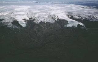 Katla volcano, near the southern end of Iceland's Eastern Volcanic Zone, comprises a central volcano, a 100 km2 caldera beneath the Mýrdalsjökull icecap, plus fissure systems. Valley glaciers descend from the summit toward the coastal plain in this aerial view from the SSW. Katla has very frequent eruptions. Explosive eruptions from the central volcano produce large volumes of tephra and are frequently accompanied by damaging glacier-outburst floods called jökulhlaups. Effusive eruptions producing large volumes of lava are characteristic of the fissure system.