Algeria Volcanoes
A map display is currently under development.
Algeria has 3 Holocene volcanoes. Note that as a scientific organization we provide these listings for informational purposes only, with no international legal or policy implications. Volcanoes will be included on this list if they are within the boundaries of a country, on a shared boundary or area, in a remote territory, or within a maritime Exclusive Economic Zone. Bolded volcanoes have erupted within the past 20 years. Suggestions and data updates are always welcome ().
| Volcano Name | Last Eruption | Volcanic Region | Primary Landform |
|---|---|---|---|
| Atakor Volcanic Field | Unknown - Evidence Credible | Hoggar Volcanic Province | Cluster |
| Manzaz Volcanic Field | Unknown - Evidence Credible | Hoggar Volcanic Province | Cluster |
| Tahalra Volcanic Field | Unknown - Evidence Credible | Hoggar Volcanic Province | Cluster |
The Global Volcanism Program is not aware of any confirmed Holocene eruptions in Algeria..
Algeria has 3 Pleistocene volcanoes. Note that as a scientific organization we provide these listings for informational purposes only, with no international legal or policy implications. Volcanoes will be included on this list if they are within the boundaries of a country, on a shared boundary or area, in a remote territory, or within a maritime Exclusive Economic Zone. Suggestions and data updates are always welcome ().
| Volcano Name | Volcanic Region | Primary Landform |
|---|---|---|
| In Teria Volcanic Field | North-Central Sahara Volcanic Province | Cluster |
| Nemours-Nedroma | Northwest Africa Volcanic Province | Cluster |
| Tafna Beni Saf | Northwest Africa Volcanic Province | Cluster |
There are 6 photos available for volcanoes in Algeria.
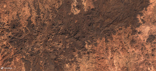
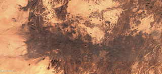 The E-W-trending Tahalra Volcanic Field within the Hoggar Province of southern Algeria covers an area of around 1,800 km2, seen here in this 3 December 2019 Sentinel-2 satellite image (N is at the top). Numerous cones and craters are visible across the image.
Satellite image courtesy of Copernicus Sentinel Data, 2019.
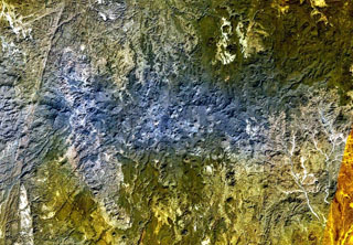
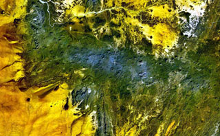 The dark-green and bluish-gray areas extending across this NASA Landsat false-color image depict the elongated, E-W-trending Tahalra volcanic field, which covers an area of about 1,800 km2 in the Hoggar Province of southern Algeria. About 100 small basaltic cones formed during the Pliocene and Pleistocene, and the most recent activity during the late-Pleistocene and Holocene, produced about 20 maars and cones along the northern margin of the volcanic field.
NASA Landsat 7 image (worldwind.arc.nasa.gov)
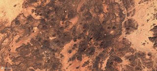 The 1,500 km2 Manzaz Volcanic Field within the Hoggar volcanic province of Algeria contains numerous generall monogenetic cones, maars, and lava flows, seen here in this 15 November 2019 Sentinel-2 satellite image (N at the top). Many scoria cones produced lava flows through the side as a flank collapsed, leaving a horseshoe-shaped edifice.
Satellite image courtesy of Copernicus Sentinel Data, 2019.
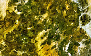 This NASA Landsat false-color image shows small scoria cones and lava flows of the Manzaz volcanic field in the Hoggar (Ahaggar) volcanic district of Algeria. The volcanic field covers an area of 1,500 km2, overlying Precambrian metamorphic and plutonic rocks of the Tuareg shield. The youngest volcanoes rest on Neolithic terraces and are of Holocene age.
NASA Landsat 7 image (worldwind.arc.nasa.gov)
 The bluish-gray area at the center of this NASA Landsat image and areas at the upper right are part of the massive Atakor volcanic field. These volcanics cover an area of 2,150 km2 and includes lava domes and abundant basaltic scoria cones and lava flows. Historical pottery has been found within lava flows in the Tahifet area, and oral traditions of the Tuareg people also suggest that eruptions were witnessed. The prominent lineament at the far left is the Inter-terrane Pan-African shear zone.
NASA Landsat 7 image (worldwind.arc.nasa.gov)
 The 2,150 km2 Atakor Volcanic Field within the Hoggar volcanic province, Algeria, contains abundant scoria cones, lava domes, and lava flows, seen across this 15 November 2019 Sentinel-2 satellite image (N at the top). Erosion has also exposed intrusions and volcanic conduits from older activity.
Satellite image courtesy of Copernicus Sentinel Data, 2019.
This is a compilation of Algeria volcano information sources, such as official monitoring or other government agencies.
| Volcanic Ash Advisory Center | |
|---|---|
| Toulouse Volcanic Ash Advisory Center (VAAC) Notices and Archive | |