Australia Volcanoes
Australia has 4 Holocene volcanoes. Note that as a scientific organization we provide these listings for informational purposes only, with no international legal or policy implications. Volcanoes will be included on this list if they are within the boundaries of a country, on a shared boundary or area, in a remote territory, or within a maritime Exclusive Economic Zone. Bolded volcanoes have erupted within the past 20 years. Suggestions and data updates are always welcome ().
| Volcano Name | Last Eruption | Volcanic Region | Primary Landform |
|---|---|---|---|
| Heard | 2025 CE | Kerguelen Hotspot Volcano Group | Composite |
| McBride Volcanic Province | 5050 BCE | Northeastern Australia Volcanic Province | Cluster |
| McDonald Islands | 2005 CE | Kerguelen Hotspot Volcano Group | Composite |
| Newer Volcanics Province | 2900 BCE | Southeastern Australia Volcanic Province | Cluster |
Chronological listing of known Holocene eruptions (confirmed or uncertain) from volcanoes in Australia. Bolded eruptions indicate continuing activity.
| Volcano Name | Start Date | Stop Date | Certainty | VEI | Evidence |
|---|---|---|---|---|---|
| Heard | 2012 Sep 5 ± 4 days | 2025 Dec 26 (continuing) | Confirmed | 0 | Observations: Reported |
| Heard | 2006 Mar 11 | 2008 Mar 3 | Confirmed | 0 | Observations: Reported |
| McDonald Islands | 2005 Jul 12 (on or before) | Unknown | Confirmed | 0 | Observations: Reported |
| McDonald Islands | [2004 Nov 14] | [2004 Nov 14] | Uncertain | ||
| Heard | 2003 Jun 9 | 2004 Jun 14 | Confirmed | 0 | Observations: Reported |
| McDonald Islands | 2001 May 3 ± 150 days | Unknown | Confirmed | 1 | Observations: Reported |
| Heard | 2000 Mar 7 (?) | 2001 Feb 16 ± 15 days | Confirmed | 2 | Observations: Reported |
| McDonald Islands | 1996 Dec 16 ± 15 days | 1997 Feb 10 ± 30 days | Confirmed | 1 | Observations: Reported |
| Heard | 1993 Jan 2 ± 15 days | Unknown | Confirmed | 2 | Observations: Reported |
| McDonald Islands | 1992 Dec 16 ± 15 days | Unknown | Confirmed | 0 | Observations: Reported |
| Heard | 1992 May 29 (?) | Unknown | Confirmed | 0 | Observations: Reported |
| Heard | [1992 Jan 17] | [1992 Jan 18] | Uncertain | ||
| Heard | 1985 Jan 14 | 1987 Jan 16 (?) ± 15 days | Confirmed | 2 | Observations: Reported |
| Heard | 1954 Apr 13 (?) | 1954 Jun 13 (?) | Confirmed | 2 | Observations: Reported |
| Heard | 1953 Aug 20 | 1953 Nov 18 | Confirmed | 2 | Observations: Reported |
| Heard | 1950 Jan 24 | 1952 Mar 12 (?) | Confirmed | 2 | Observations: Reported |
| Heard | 1910 Mar | 1910 Apr | Confirmed | 2 | Observations: Reported |
| Heard | [1881 Jun 2] | [Unknown] | Uncertain | ||
| Newer Volcanics Province | 2900 BCE ± 150 years | Unknown | Confirmed | Isotopic: 14C (uncalibrated) | |
| Newer Volcanics Province | 3000 BCE ± 500 years | Unknown | Confirmed | Radiogenic: Fission track | |
| McBride Volcanic Province | 5050 BCE ± 2000 years | Unknown | Confirmed | Isotopic: Ar/Ar | |
| Newer Volcanics Province | 5290 BCE (in or before) | Unknown | Confirmed | Isotopic: 14C (uncalibrated) | |
| Newer Volcanics Province | 5850 BCE (?) | Unknown | Confirmed | Isotopic: 14C (uncalibrated) |
Australia has 9 Pleistocene volcanoes. Note that as a scientific organization we provide these listings for informational purposes only, with no international legal or policy implications. Volcanoes will be included on this list if they are within the boundaries of a country, on a shared boundary or area, in a remote territory, or within a maritime Exclusive Economic Zone. Suggestions and data updates are always welcome ().
| Volcano Name | Volcanic Region | Primary Landform |
|---|---|---|
| Atherton Basalt Province | Northeastern Australia Volcanic Province | Cluster |
| Bundaberg-Boyne Province | East Central Australia Volcanic Provinces | Minor |
| Chudleigh Volcanic Province | Northeastern Australia Volcanic Province | Cluster |
| Fox | Northeastern Australia Volcanic Province | Minor |
| Maer Volcanic Province | Northeastern Australia Volcanic Province | Cluster |
| Mclean Volcanic Province | Northeastern Australia Volcanic Province | Cluster |
| Nulla Volcanic Province | Northeastern Australia Volcanic Province | Cluster |
| Piebald Volcanic Province | Northeastern Australia Volcanic Province | Cluster |
| Sturgeon Volcanic Province | Northeastern Australia Volcanic Province | Shield |
There are 5 photos available for volcanoes in Australia.
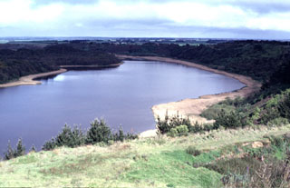 Lake-filled Tower Hill maar is part of the voluminous Newer Volcanics Province, which covers a broad 15,000 km2 area of SE Australia. The volcanic field contains nearly 400 vents, with late-Pleistocene to Holocene eruptions producing scoria cones, maars, tuff rings, and valley-filling lava flows. The most recent eruptions took place at Mount Schank and Mount Gambier.
Photo by Jim Luhr, 1993 (Smithsonian Institution).
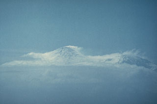 A plume, seen here from a ship to the SW, drifts from the summit of Heard volcano on 14 January 1985. Incandescence and a lava flow were observed that night from the ship 25 km offshore and an eruption plume was visible for two days. Eruptive activity may have continued into 1987. An active lava lake in a new crater was observed during a December 1986-January 1987 summit expedition. A lava flow, probably dating back to January 1985, was seen descending 8-9 km from the summit.
Photo by André Giret, Expéditions Polaires Françaises, 1985.
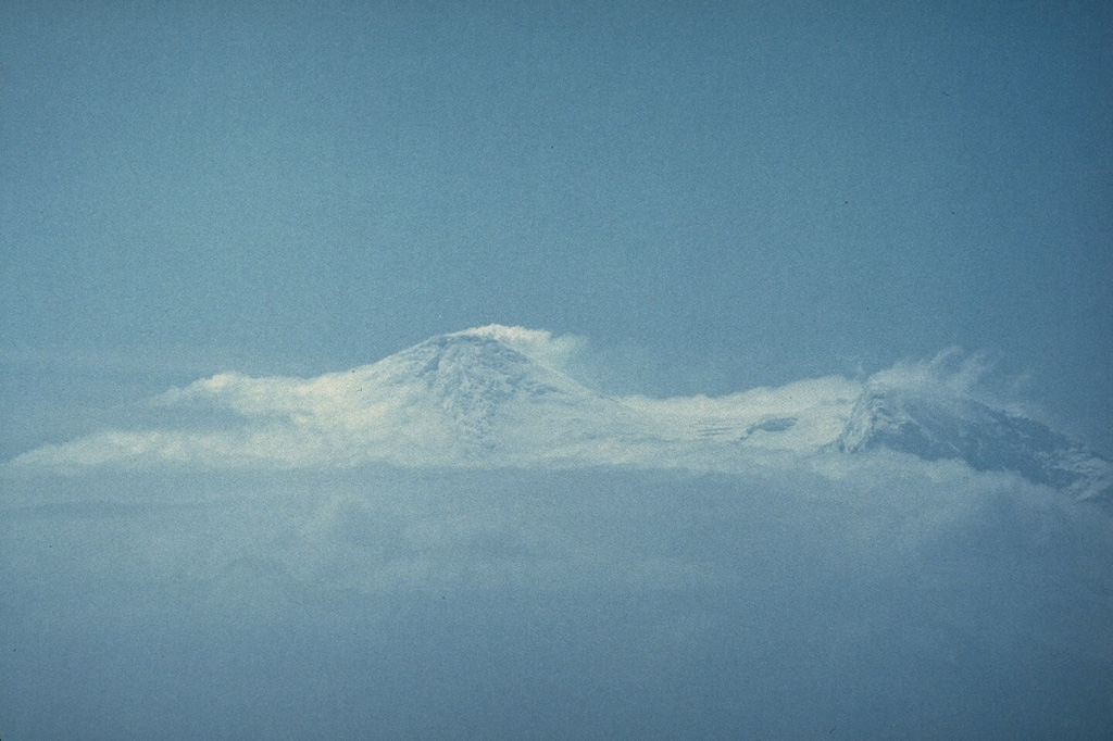
 A plume rises in 1985 or 1986 from the summit of Big Ben volcano on Heard Island in the southern Indian Ocean. It is seen here from an abandoned Australian geophysical station at Atlas Cove, NNW of the summit. The historically active Mawson Peak forms the island's high point and lies within a 5-6 km wide caldera breached to the SW side of Big Ben. Small satellite scoria cones are mostly located on the N coast. Several subglacial eruptions have been reported.
Photo by A. Hitchman, 1985 (courtesy of Wally Johnson, Australian BMRGG, Canberra).
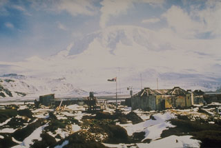
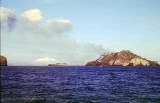 Three small, low islands on the Kerguelen Plateau form the McDonald Islands. The largest island, McDonald, is only 1 km2 in area and around 200 m high. This April 1997 photo shows a plume at Samarang Hill (right). The Island is composed of a layered tuff plateau cut by dikes and lava domes. A possible nearby active submarine center was inferred from pumice that washed up on Heard Island in 1992. The snow-capped peak in the background is Heard volcano, 44 km to the E.
Copyrighted photo by Richard Williams, 1997 (Australian Antarctic Div., published in Global Volcanism Network Bulletin).
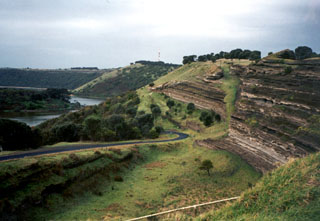 Tower Hill maar, with bedded pyroclastic layers exposed in its wall, is part of the voluminous Newer Volcanics Province, which covers a broad 15,000 km2 area of SE Australia. The volcanic field contains nearly 400 vents, with late-Pleistocene to Holocene eruptions producing scoria cones, maars, tuff rings, and valley-filling lava flows. The most recent eruptions took place at Mount Schank and Mount Gambier.
Photo by Monica Handler, 1995 (Carnegie Institution).
This is a compilation of Australia volcano information sources, such as official monitoring or other government agencies.
| Volcanic Ash Advisory Center |
|---|
| Darwin Volcanic Ash Advisory Centre (VAAC) |
| - Darwin VAAC Archive |