Chad Volcanoes
-
Tarso Tousside
-
Tarso Voon
-
Tarso Tousside
-
Tarso Voon
-
Tarso Voon
-

Tarso Tousside
-

Emi Koussi
-
Tarso Voon
-

Tarso Toh
Chad has 4 Holocene volcanoes. Note that as a scientific organization we provide these listings for informational purposes only, with no international legal or policy implications. Volcanoes will be included on this list if they are within the boundaries of a country, on a shared boundary or area, in a remote territory, or within a maritime Exclusive Economic Zone. Bolded volcanoes have erupted within the past 20 years. Suggestions and data updates are always welcome ().
| Volcano Name | Last Eruption | Volcanic Province | Primary Landform |
|---|---|---|---|
| Emi Koussi | Unknown - Evidence Credible | Tibesti Volcanic Province | Shield |
| Tarso Toh | Unknown - Evidence Credible | Tibesti Volcanic Province | Cluster |
| Tarso Tousside | Unknown - Evidence Credible | Tibesti Volcanic Province | Composite |
| Tarso Voon | Unknown - Unrest / Holocene | Tibesti Volcanic Province | Composite |
The Global Volcanism Program is not aware of any confirmed Holocene eruptions in Chad..
Chad has 2 Pleistocene volcanoes. Note that as a scientific organization we provide these listings for informational purposes only, with no international legal or policy implications. Volcanoes will be included on this list if they are within the boundaries of a country, on a shared boundary or area, in a remote territory, or within a maritime Exclusive Economic Zone. Suggestions and data updates are always welcome ().
| Volcano Name | Volcanic Province | Primary Volcano Type |
|---|---|---|
| Tarso Ahon | Tibesti Volcanic Province | Cluster |
| Tarso Emi Chi | Tibesti Volcanic Province | Cluster |
There are 9 photos available for volcanoes in Chad.
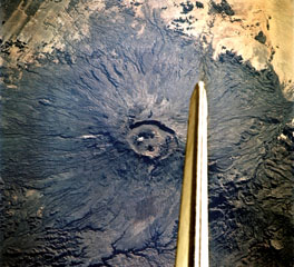
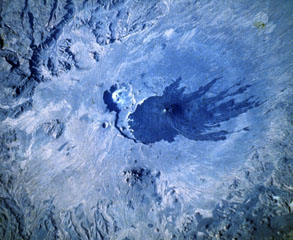 Dark lava flows radiate from Toussidé volcano (center), the second highest peak of the Tibesti Range in Chad. N to the bottom of this Space Shuttle image. It was constructed at the W end of the large Pleistocene caldera of Yirrigue, whose scarp is seen left of Toussidé. The smaller 8-km-wide caldera of Trou au Natron cuts the SE rim of the caldera. Ehi Timi (lower center) and Ehi Sosso (left center) volcanoes are located on the flanks of the massif.
NASA Space Shuttle image S-511-42, 1985 (http://eol.jsc.nasa.gov/).
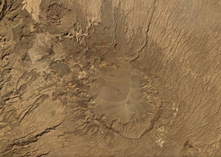
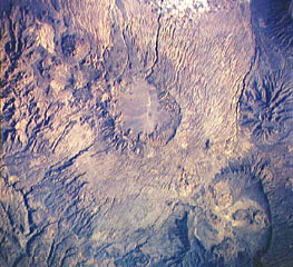 The circular area near the center of this Space Shuttle image is the shallow 14 x 18 km wide summit caldera of Tarso Voon volcano in the west-central part of the Tibesti Range. Quaternary basalts were erupted from vents near the caldera rim and from Ehi Mousgau, a small stratovolcano visible to the NW. The large Soborom solfatara field west of the massif, with its active mud pots and boiling waters, is visited by Tibesti peoples for medicinal uses. Pleistocene Tarso Yéga caldera to the SE is at the lower right.
NASA Space Shuttle image STS41B-42-2521 1984 (http://eol.jsc.nasa.gov/).
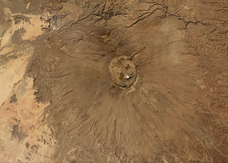
 The vertical stabilizer of the Space Shuttle Endeavor appears above the summit caldera of Emi Koussi volcano at the SE end of the Tibesti Range in Chad. Nested 12 x 15 km wide calderas at the summit contain large craters and young basaltic scoria cones.
NASA Space Shuttle image STS108-701-008, 2001 (http://eol.jsc.nasa.gov/).
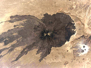 A dramatic Space Shuttle image shows dark lava flows radiating from Toussidé volcano and spreading across the desert floor. Light-colored altered areas can be seen at the summit, the second highest peak of the Tibesti Range in Chad. It was constructed at the W end of the large Pleistocene caldera of Yirrigue, whose E scarp is seen right of Toussidé. The smaller 1-km-deep, 8-km-wide Trou au Natron caldera (lower right) cuts the SE rim of the caldera.
NASA Space Shuttle image STS111-367-29, 2002 (http://eol.jsc.nasa.gov/).
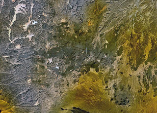 Small scoria cones and lava flows of the Tarso Tôh volcanic field can be seen in the large darker-brown area at the center of this NASA Landsat image. This Pleistocene-to-Holocene volcanic field in the Tibesti Range of Chad covers a 30 x 80 km area and contains 150 scoria cones and two maars. Basaltic lava flows at Tarso Tôh were erupted over a basement of Precambrian schists and Paleozoic sandstones. The black lava flows at the very bottom-center are distal lava flows from Tarso Toussidé volcano.
NASA Landsat 7 image (worldwind.arc.nasa.gov)
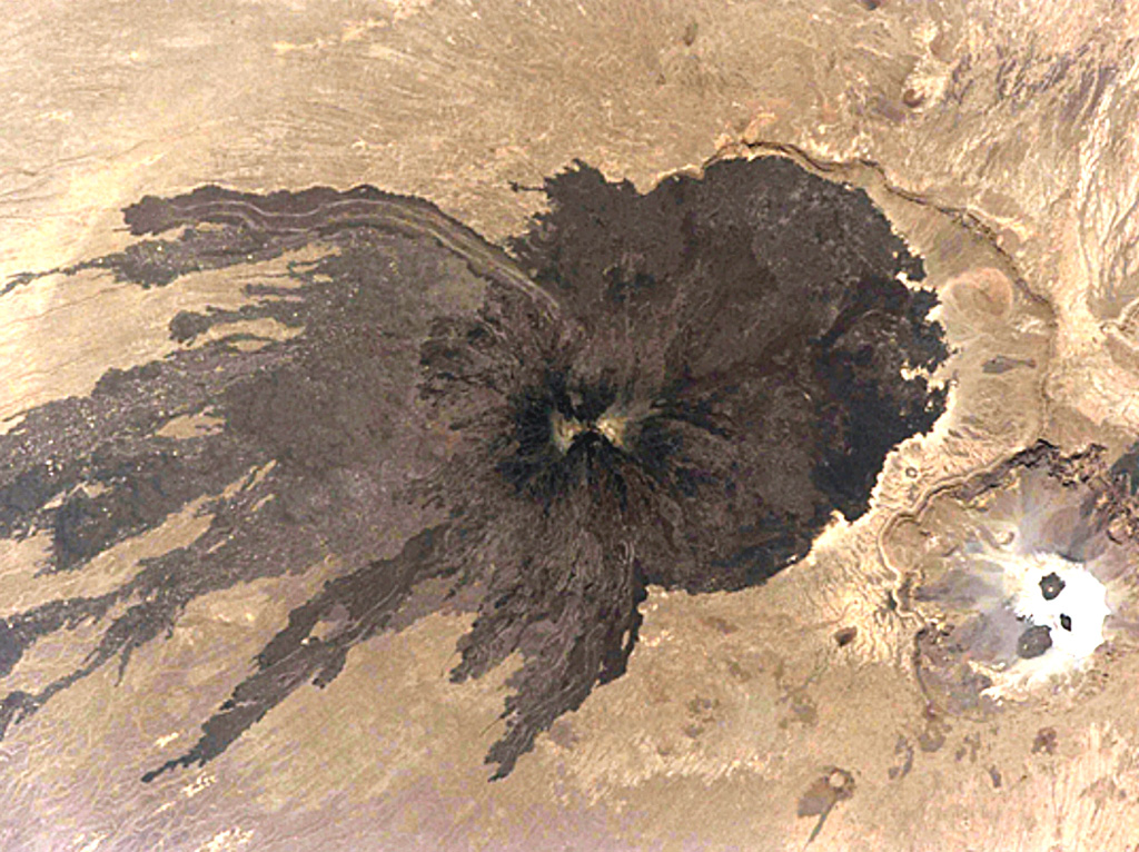
 Tarso Toussidé is a nested caldera system in the Tibesti massif in Chad, seen in this November 2019 Planet Labs satellite image monthly mosaic (N is at the top; this image is approximately 44 km across). Trou au Natron is the caldera along the SE boundary, the crater to the NNE is Petit Trou/Doon Kidimi. The long, narrow lava flow to the NW is one of the more recent eruptive products.
Satellite image courtesy of Planet Labs Inc., 2019 (https://www.planet.com/).
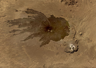
 Emi Koussi is the largest volcano of the Tibesti massif in Chad, with a diameter of 60-70 km and a summit crater approximately 13.5 x 11 km in size, seen in this this November 2019 Planet Labs satellite image monthly mosaic (N is at the top; this image is approximately 92 km across). Smaller cones and vents can be seen within the caldera and on the flanks.
Satellite image courtesy of Planet Labs Inc., 2019 (https://www.planet.com/).
 The Tarso Voon caldera within the Tibesti massif in Chad is shown in this November 2019 Planet Labs satellite image monthly mosaic (N is at the top; this image is approximately 48 km across). The Soborom geothermal field is on the W flank and several smaller cones and craters are visible along the N flank.
Satellite image courtesy of Planet Labs Inc., 2019 (https://www.planet.com/).
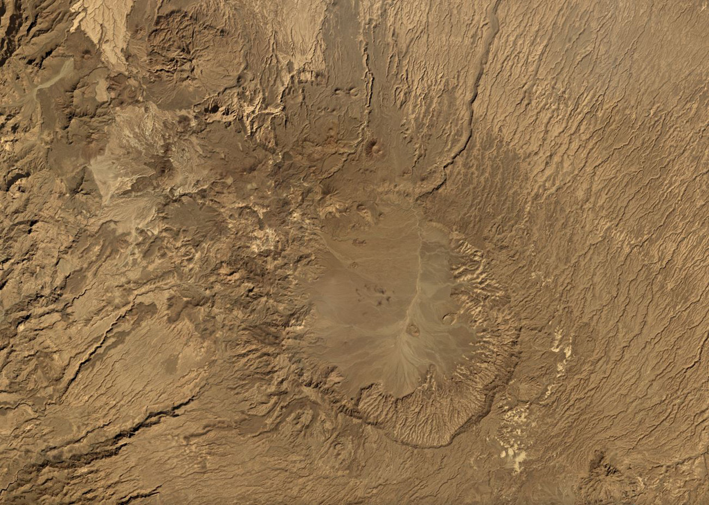
 Scoria cones, craters, and lava flows are visible across the Tarso Tôh volcanic field in this 3 December 2019 Sentinel-2 satellite image (N at the top). This field in the NW portion of the Tibesti Range of Chad contains around 150 identified volcanic centers. This image shows an area approximately 45 km across.
Satellite image courtesy of Copernicus Sentinel Data, 2019.
This is a compilation of Chad volcano information sources, such as official monitoring or other government agencies.
| Volcanic Ash Advisory Center | |
|---|---|
| Toulouse Volcanic Ash Advisory Center (VAAC) Notices and Archive | |