
The Pusat Vulkanologi dan Mitigasi Bencana Geologi (PVMBG) reported that eruptive activity at Dukono continued during 24-30 September. White-and-gray gas-and-ash plumes rose as high as 700 m above the summit on most days and drifted E, NW, and W. White plumes rose as high as 200 m above the summit and drifted E and SW on 26 and 29 September. The Alert Level remained at Level 2 (on a scale of 1-4) and the public was warned to stay 4 km away from the Malupang Warirang Crater.
Source: Pusat Vulkanologi dan Mitigasi Bencana Geologi (PVMBG, also known as CVGHM)
Continuing SO2 plumes and thermal anomalies; strong ash emissions in October-November 2023
Dukono, a remote volcano on Indonesia’s Halmahera Island, has been erupting continuously since 1933, with frequent ash explosions and sulfur dioxide plumes (BGVN 48:06). This activity continued during June-November 2023, based on reports from the Pusat Vulkanologi dan Mitigasi Bencana Geologi (PVMBG; also known as Indonesian Center for Volcanology and Geological Hazard Mitigation, CVGHM), the Darwin Volcanic Ash Advisory Centre (VAAC), and satellite data.
Webcam photos posted to MAGMA Indonesia (a platform developed by PVMBG) showed that, white, gray, or dark plumes of variable densities were observed almost every day during the reporting period (figure 35), except when fog obscured the volcano. Plume heights ranged up to 2,500 m above the summit. Images during 7 October-27 November 2023. During the first week of November ashfall up to 0.5 mm thick fell in several areas downwind, including Mede, Popilo, Gorua (4.5 km ENE), Waro ino-Weri, Buwaele, Gura, Cina, Gamsungi, and Tobelo (15 km ENE). Banging noises were also heard several times in the same villages.
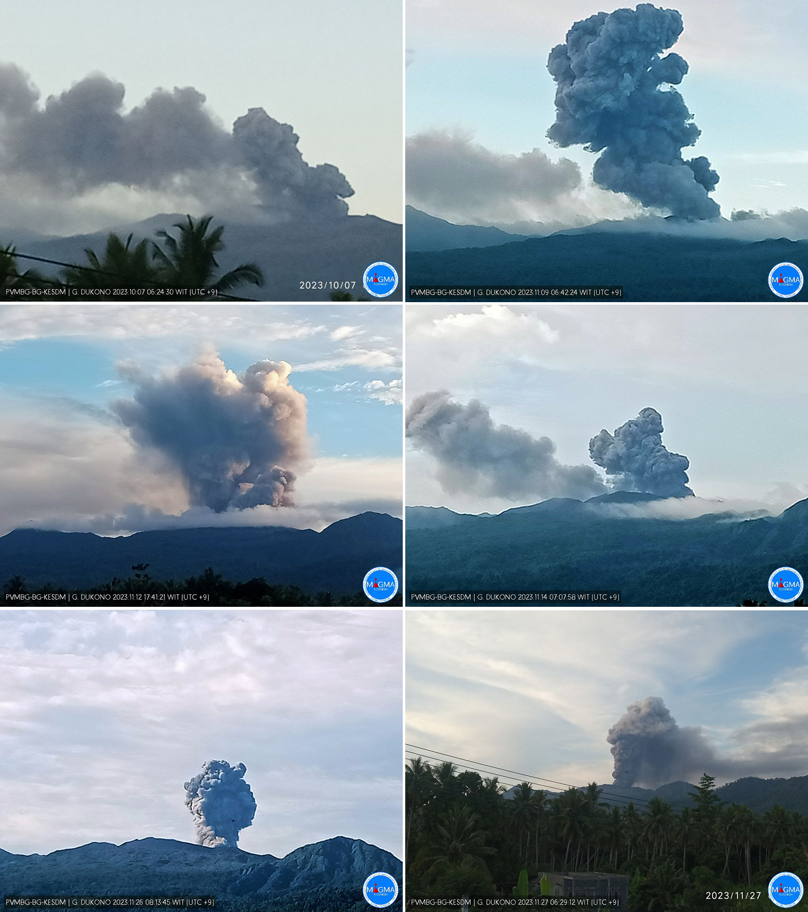 |
Figure 35. Webcam photos of Dukono showing ash plumes during October-November 2023. Courtesy of MAGMA Indonesia. |
Thermal anomalies recorded by the MIROVA system were infrequent during this period except for approximately mid-October through mid-November 2023, corresponding to observations of ashfall. MODVOLC thermal alerts were recorded on 25 October, 10 November, and 15 November 2023. Weather clouds or steam plumes often prevented clear satellite views, but a distinct thermal anomaly at the center of the summit crater was observed in Sentinel-2 images on 24 June, 29 July, 7 October, 12 October, 27 October, 1 November, and 26 November. Sulfur dioxide plumes were detected by the TROPOMI instrument aboard the Sentinel-5P satellite (figure 36) on roughly half the days each month during the reporting period, with fewer in July and more in November.
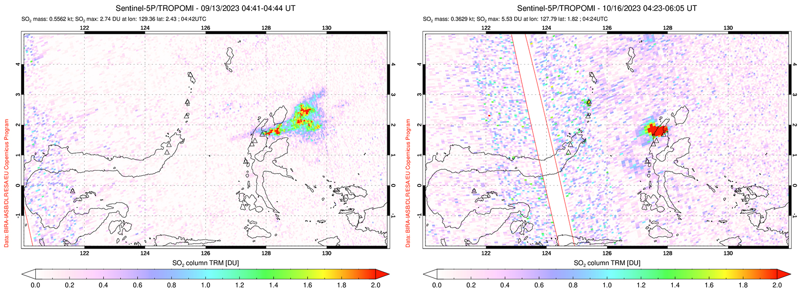 |
Figure 36. Strong SO2 plumes from Dukono are depicted from 13 September and 16 October 2023 using data from the TROPOMI instrument on the Sentinel-5P satellite. Courtesy of the NASA Global Sulfur Dioxide Monitoring Page. |
Information Contacts: Pusat Vulkanologi dan Mitigasi Bencana Geologi (PVMBG, also known as Indonesian Center for Volcanology and Geological Hazard Mitigation, CVGHM), Jalan Diponegoro 57, Bandung 40122, Indonesia (URL: http://www.vsi.esdm.go.id/); MAGMA Indonesia (Multiplatform Application for Geohazard Mitigation and Assessment in Indonesia), Kementerian Energi dan Sumber Daya Mineral (URL: https://magma.esdm.go.id/v1); Darwin Volcanic Ash Advisory Centre (VAAC), Bureau of Meteorology, Northern Territory Regional Office, PO Box 40050, Casuarina, NT 0811, Australia (URL: http://www.bom.gov.au/info/vaac/); NASA Global Sulfur Dioxide Monitoring Page, Atmospheric Chemistry and Dynamics Laboratory, NASA Goddard Space Flight Center (NASA/GSFC), 8800 Greenbelt Road, Goddard, Maryland, USA (URL: https://so2.gsfc.nasa.gov/); Copernicus Browser, Copernicus Data Space Ecosystem, European Space Agency (URL: https://dataspace.copernicus.eu/browser/); MIROVA (Middle InfraRed Observation of Volcanic Activity), a collaborative project between the Universities of Turin and Florence (Italy) supported by the Centre for Volcanic Risk of the Italian Civil Protection Department (URL: http://www.mirovaweb.it/).
2025: January
| February
| March
| April
| May
| June
| July
| August
| September
2024: January
| February
| March
| April
| May
| June
| July
| August
| September
| October
| November
| December
2023: February
| March
| April
| May
| July
| August
| September
| November
| December
2022: February
| March
| April
| May
| June
| July
| August
| November
| December
2021: January
| February
| March
| April
| May
| June
| July
| August
| October
| November
2020: January
| February
| March
| April
| May
| June
| July
| August
| September
| October
| November
| December
2019: January
| February
| March
| April
| May
| June
| July
| August
| September
| October
| November
| December
2018: January
| February
| March
| April
| May
| June
| July
| August
| September
| October
| November
| December
2017: January
| February
| March
| April
| May
| June
| July
| August
| September
| October
| November
| December
2016: January
| February
| March
| April
| May
| June
| July
| August
| September
| October
| November
| December
2015: January
| February
| March
| April
| May
| June
| July
| August
| September
| October
| November
| December
2014: January
| February
| March
| April
| May
| June
| July
| August
| September
| October
| November
2013: August
| September
| October
| December
2012: January
| February
| May
| June
2011: January
| February
| March
| April
| May
| June
| July
| August
| September
| October
| November
| December
2010: February
| March
| April
| May
| June
| July
| August
| September
| October
| November
| December
2009: January
| February
| April
| May
| June
| July
| August
| September
| October
| November
| December
2008: May
| June
| July
| August
| September
| October
| November
| December
2007: January
| June
2006: January
| August
| November
| December
2005: February
| May
| June
| August
| September
| October
2004: January
| February
| March
| April
| May
| June
| August
| September
2003: June
| July
| August
| September
| October
| November
| December
The Pusat Vulkanologi dan Mitigasi Bencana Geologi (PVMBG) reported that eruptive activity at Dukono continued during 24-30 September. White-and-gray gas-and-ash plumes rose as high as 700 m above the summit on most days and drifted E, NW, and W. White plumes rose as high as 200 m above the summit and drifted E and SW on 26 and 29 September. The Alert Level remained at Level 2 (on a scale of 1-4) and the public was warned to stay 4 km away from the Malupang Warirang Crater.
Source: Pusat Vulkanologi dan Mitigasi Bencana Geologi (PVMBG, also known as CVGHM)
The Pusat Vulkanologi dan Mitigasi Bencana Geologi (PVMBG) reported that eruptive activity at Dukono continued during 17-23 September. White-and-gray gas-and-ash plumes rose as high as 800 m above the summit on most days and drifted in multiple directions; plumes were not visible on 23 September. The Alert Level remained at Level 2 (on a scale of 1-4) and the public was warned to stay 4 km away from the Malupang Warirang Crater.
Source: Pusat Vulkanologi dan Mitigasi Bencana Geologi (PVMBG, also known as CVGHM)
The Pusat Vulkanologi dan Mitigasi Bencana Geologi (PVMBG) reported that eruptive activity at Dukono continued during 9-16 September. Daily white-and-gray gas-and-ash plumes rose as high as 1 km above the summit and drifted in multiple directions. The Alert Level remained at Level 2 (on a scale of 1-4) and the public was warned to stay 4 km away from the Malupang Warirang Crater.
Source: Pusat Vulkanologi dan Mitigasi Bencana Geologi (PVMBG, also known as CVGHM)
The Pusat Vulkanologi dan Mitigasi Bencana Geologi (PVMBG) reported that eruptive activity at Dukono continued during 27 August-2 September. White-and-gray gas-and-ash plumes rose as high as 700 m above the summit and drifted NW, W, and SW. Emissions were not visible on 6 September. The Alert Level remained at Level 2 (on a scale of 1-4) and the public was warned to stay 4 km away from the Malupang Warirang Crater.
Source: Pusat Vulkanologi dan Mitigasi Bencana Geologi (PVMBG, also known as CVGHM)
The Pusat Vulkanologi dan Mitigasi Bencana Geologi (PVMBG) reported that eruptive activity at Dukono continued during 27 August-2 September. Daily white-and-gray gas-and-ash plumes rose 100-600 m above the summit and drifted NW and E. The Alert Level remained at Level 2 (on a scale of 1-4) and the public was warned to stay 4 km away from the Malupang Warirang Crater.
Source: Pusat Vulkanologi dan Mitigasi Bencana Geologi (PVMBG, also known as CVGHM)
The Pusat Vulkanologi dan Mitigasi Bencana Geologi (PVMBG) reported that eruptive activity at Dukono continued during 20-26 August. Dense white-and-gray gas-and-ash plumes rose 200-900 m above the summit and drifted NW and E during 21-23 and 26 August. The Alert Level remained at Level 2 (on a scale of 1-4) and the public was warned to stay 4 km away from the Malupang Warirang Crater.
Source: Pusat Vulkanologi dan Mitigasi Bencana Geologi (PVMBG, also known as CVGHM)
The Pusat Vulkanologi dan Mitigasi Bencana Geologi (PVMBG) reported that eruptive activity at Dukono continued during 13-19 August. Daily white-and-gray gas-and-ash plumes rose as high as 700 m above the summit and drifted W, NW, E, and NE. The Alert Level remained at Level 2 (on a scale of 1-4) and the public was warned to stay 4 km away from the Malupang Warirang Crater.
Source: Pusat Vulkanologi dan Mitigasi Bencana Geologi (PVMBG, also known as CVGHM)
The Pusat Vulkanologi dan Mitigasi Bencana Geologi (PVMBG) reported that eruptive activity at Dukono continued during 6-12 August. White-and-gray gas-and-ash plumes rose 100-800 m above the summit and drifted in multiple directions on most days; white plumes rose 200-700 m above the summit and drifted NE and E on 7 August. The Alert Level remained at Level 2 (on a scale of 1-4) and the public was warned to stay 4 km away from the Malupang Warirang Crater.
Source: Pusat Vulkanologi dan Mitigasi Bencana Geologi (PVMBG, also known as CVGHM)
The Pusat Vulkanologi dan Mitigasi Bencana Geologi (PVMBG) reported that eruptive activity at Dukono continued during 30 July-5 August. White-and-gray gas-and-ash plumes rose 100-700 m above the summit and drifted in multiple directions on most days. The number of seismically recorded explosions varied from 9 to 174 per day, with the highest value recorded on 2 August. The Alert Level remained at Level 2 (on a scale of 1-4) and the public was warned to stay 4 km away from the Malupang Warirang Crater.
Source: Pusat Vulkanologi dan Mitigasi Bencana Geologi (PVMBG, also known as CVGHM)
The Pusat Vulkanologi dan Mitigasi Bencana Geologi (PVMBG) reported that eruptive activity at Dukono continued during 23-29 July. White-and-gray gas-and-ash plumes rose 700-3,500 m above the summit and drifted in multiple directions on most days; weather conditions obscured views on 26 July. Ashfall was reported from Ruko (11 km NW) to Tobelo City (15 km ENE) on 24 July, and in Mamuya Village (8 km N) and surrounding areas on 26 and 28 July. The Alert Level remained at Level 2 (on a scale of 1-4) and the public was warned to stay 4 km away from the Malupang Warirang Crater.
Source: Pusat Vulkanologi dan Mitigasi Bencana Geologi (PVMBG, also known as CVGHM)
The Pusat Vulkanologi dan Mitigasi Bencana Geologi (PVMBG) reported that eruptive activity at Dukono continued during 16-22 July. Daily white-and-gray gas-and-ash plumes rose 600-1,200 m above the summit and drifted NE and E. Faint booming and rumbling was heard at the observation post, 11 km N, during 16-17 July. Ashfall was reported in Tobelo City (15 km ENE) and surrounding areas (10-15 km ENE) during 18-19 July. The Alert Level remained at Level 2 (on a scale of 1-4) and the public was warned to stay 4 km away from the Malupang Warirang Crater.
Source: Pusat Vulkanologi dan Mitigasi Bencana Geologi (PVMBG, also known as CVGHM)
The Pusat Vulkanologi dan Mitigasi Bencana Geologi (PVMBG) reported that eruptive activity at Dukono continued during 9-15 July. Daily white-and-gray or gray-to-black gas-and-ash plumes rose 400-1,200 m above the summit and drifted NE and E. Faint booming and rumbling was heard and felt by residents 10-11 km away. The Alert Level remained at Level 2 (on a scale of 1-4) and the public was warned to stay 4 km away from the Malupang Warirang Crater.
Source: Pusat Vulkanologi dan Mitigasi Bencana Geologi (PVMBG, also known as CVGHM)
The Pusat Vulkanologi dan Mitigasi Bencana Geologi (PVMBG) reported that eruptive activity at Dukono continued during 2-8 July. Daily white-and-gray or gray-to-black gas-and-ash plumes rose 600-1,600 m above the summit and drifted NW and E. Faint booming and rumbling was heard by residents and at the observation post, 10-11 km N, during 4-5 July. Ashfall was reported in areas downwind including at the Mamuya Village Observation post and in Tobelo City (15 km ENE); more ash fell in areas of Tobelo City during 6-7 July. The Alert Level remained at Level 2 (on a scale of 1-4) and the public was warned to stay 4 km away from the Malupang Warirang Crater.
Source: Pusat Vulkanologi dan Mitigasi Bencana Geologi (PVMBG, also known as CVGHM)
The Pusat Vulkanologi dan Mitigasi Bencana Geologi (PVMBG) reported that eruptive activity at Dukono continued during 25 June-1 July. Daily white-and-gray or white, gray, and black gas-and-ash plumes rose 400-1,200 m above the summit and drifted NE and E. Booming, rumbling, and/or banging was heard by residents and at the observation post, 10-11 km N, during 25 and 28-30 June and on 1 July. The Alert Level remained at Level 2 (on a scale of 1-4) and the public was warned to stay 4 km away from the Malupang Warirang Crater.
Source: Pusat Vulkanologi dan Mitigasi Bencana Geologi (PVMBG, also known as CVGHM)
The Pusat Vulkanologi dan Mitigasi Bencana Geologi (PVMBG) reported that eruptive activity at Dukono continued during 18-24 June. Daily white-and-gray or white, gray, and black gas-and-ash plumes rose 500-2,700 m above the summit and drifted SE, E, and NW. Faint rumbling was heard at the observation post, 11 km N, during 6-7 June. Residents 10-11 km away heard occasional booming and rumbling sounds during 18 and 22-24 June. The Alert Level remained at Level 2 (on a scale of 1-4) and the public was warned to stay 4 km away from the Malupang Warirang Crater.
Source: Pusat Vulkanologi dan Mitigasi Bencana Geologi (PVMBG, also known as CVGHM)
The Pusat Vulkanologi dan Mitigasi Bencana Geologi (PVMBG) reported that eruptive activity at Dukono continued during 11-17 June. Daily white-and-gray gas-and-ash plumes rose 100-2,500 m above the summit. Winds blew the ash to the E and NE during 11-12 June, then N and NW during 13 -17 June. A special report from PVBMG on 15 June noted that plume heights over 14-15 June were 1,500-2,500 m above the summit. The Alert Level remained at Level 2 (on a scale of 1-4) and the public was warned to stay 4 km away from the Malupang Warirang Crater.
Source: Pusat Vulkanologi dan Mitigasi Bencana Geologi (PVMBG, also known as CVGHM)
The Pusat Vulkanologi dan Mitigasi Bencana Geologi (PVMBG) reported that eruptive activity at Dukono continued during 4-10 June. Daily white-and-gray gas-and-ash plumes rose 100-1,500 m above the summit and drifted E. Faint rumbling was heard at the observation post, 11 km N, during 6-7 June. Residents 10-11 km away hard occasional banging and rumbling sounds on 10 June. The Alert Level remained at Level 2 (on a scale of 1-4) and the public was warned to stay 4 km away from the Malupang Warirang Crater.
Source: Pusat Vulkanologi dan Mitigasi Bencana Geologi (PVMBG, also known as CVGHM)
The Pusat Vulkanologi dan Mitigasi Bencana Geologi (PVMBG) reported that eruptive activity at Dukono continued during 28 May-3 June. Daily white-and-gray or white, gray, and black gas-and-ash plumes rose 900-1,900 m above the summit and drifted NW, W, and S. The emissions were described as ongoing through the week. Residents 10-11 km away felt vibrations from the activity on 29 May and occasional banging sounds were heard at the same distances during 29-30 May. Faint rumbling was heard at the observation post, 11 km N, during 31 May-1 June. The Alert Level remained at Level 2 (on a scale of 1-4) and the public was warned to stay 4 km away from the Malupang Warirang Crater.
Source: Pusat Vulkanologi dan Mitigasi Bencana Geologi (PVMBG, also known as CVGHM)
The Pusat Vulkanologi dan Mitigasi Bencana Geologi (PVMBG) reported that eruptive activity at Dukono continued during 14-20 May. Daily white-and-gray or white, gray, and black gas-and-ash plumes rose 600-1,500 m above the summit and drifted N, NE, E, and SE. The emissions were continuous most of the day on 14 May, during approximately 0517-1703 on 15 May, from about 0803 on 16 May to about 2217 on 19 May, and during the morning of 20 May. The Alert Level remained at Level 2 (on a scale of 1-4) and the public was warned to stay 4 km away from the Malupang Warirang Crater.
Source: Pusat Vulkanologi dan Mitigasi Bencana Geologi (PVMBG, also known as CVGHM)
The Pusat Vulkanologi dan Mitigasi Bencana Geologi (PVMBG) reported that eruptive activity at Dukono continued during 7-13 May. Daily gas-and-ash plumes rose 100-1,500 m above the summit and drifted E, SE, and S. The Alert Level remained at Level 2 (on a scale of 1-4) and the public was warned to stay 4 km away from the Malupang Warirang Crater.
Source: Pusat Vulkanologi dan Mitigasi Bencana Geologi (PVMBG, also known as CVGHM)
The Pusat Vulkanologi dan Mitigasi Bencana Geologi (PVMBG) reported that eruptive activity at Dukono continued at high levels through 6 May. Daily eruptive events in 2025 were in the 60-394 range, with an average of 227 per day. Gas-and-ash plumes generally rose 200-2,500 m above the summit, though during 27 March-30 April plumes rose as high as 1,400 m above the summit. The plumes drifted E, NW, and W towards populated areas. On 30 April occasional rumbling was followed by a strong boom felt by residents as far as 11 km away. During 1-6 May white-and-gray ash plumes rose 100-1,500 m above the crater rim and drifted in variable directions. Minor ashfall was reported in Mamuya, 11 km N, on 1 May and rumbling was heard during 1-2 May. The Alert Level remained at Level 2 (on a scale of 1-4) and the public was warned to stay 4 km away from the Malupang Warirang Crater.
Source: Pusat Vulkanologi dan Mitigasi Bencana Geologi (PVMBG, also known as CVGHM)
The Pusat Vulkanologi dan Mitigasi Bencana Geologi (PVMBG) reported that the eruption at Dukono continued during 23-29 April. White-and-gray ash plumes rose 600-1,100 m above the crater rim and drifted E on most days; no plumes were visible on 24 April. The Alert Level remained at Level 2 (on a scale of 1-4) and the public was warned to stay 4 km away from the Malupang Warirang Crater.
Source: Pusat Vulkanologi dan Mitigasi Bencana Geologi (PVMBG, also known as CVGHM)
The Pusat Vulkanologi dan Mitigasi Bencana Geologi (PVMBG) reported that the eruption at Dukono continued during 16-22 April. White-and-gray ash plumes that were sometimes dense rose 600-1,500 m above the crater rim and drifted in multiple directions. Occasional rumbling and banging sounds were heard during 19-20 April. The Alert Level remained at Level 2 (on a scale of 1-4) and the public was warned to stay 4 km away from the Malupang Warirang Crater.
Source: Pusat Vulkanologi dan Mitigasi Bencana Geologi (PVMBG, also known as CVGHM)
The Pusat Vulkanologi dan Mitigasi Bencana Geologi (PVMBG) reported that the eruption at Dukono continued during 9-15 April. White-and-gray ash plumes rose 200-1,000 m above the crater rim and drifted in multiple directions. Ash plumes were reported during 10-15 April that rose 600-1,300 m above the crater and drifted in different directions. On 11 April at 1038 a white-to-gray ash plume rose 1.3 km above the summit and drifted SE to S. The Alert Level remained at Level 2 (on a scale of 1-4) and the public was warned to stay 4 km away from the Malupang Warirang Crater.
Source: Pusat Vulkanologi dan Mitigasi Bencana Geologi (PVMBG, also known as CVGHM)
The Pusat Vulkanologi dan Mitigasi Bencana Geologi (PVMBG) reported that the eruption at Dukono continued during 2-8 April. White-and-gray ash plumes rose 400-3,300 m above the crater rim and drifted in multiple directions. The Alert Level remained at Level 2 (on a scale of 1-4) and the public was warned to stay 4 km away from the Malupang Warirang Crater.
Source: Pusat Vulkanologi dan Mitigasi Bencana Geologi (PVMBG, also known as CVGHM)
The Pusat Vulkanologi dan Mitigasi Bencana Geologi (PVMBG) reported that the eruption at Dukono was ongoing during 26 March-1 April. Daily dense white-and-gray or gray ash plumes rose as high as 2.5 km above the crater rim and drifted in multiple directions. Rumbling and banging sounds were sometimes accompanied by strong booms during 26-28 March. The Alert Level remained at Level 2 (on a scale of 1-4) and the public was warned to stay 4 km away from the Malupang Warirang Crater.
Source: Pusat Vulkanologi dan Mitigasi Bencana Geologi (PVMBG, also known as CVGHM)
The Pusat Vulkanologi dan Mitigasi Bencana Geologi (PVMBG) reported that the eruption at Dukono was ongoing during 19-25 March. White-and-gray or gray ash plumes that were often dense rose as high as 1.1 km above the crater rim and drifted NW, W, E, and NE on all days except 23 March. Rumbling and banging sounds were sometimes accompanied by strong booms during 19 and 24-25 March. Ashfall was reported in Tobelo (15 km ENE) and surrounding areas during 24-25 March. The Alert Level remained at Level 2 (on a scale of 1-4) and the public was warned to stay 4 km away from the Malupang Warirang Crater.
Source: Pusat Vulkanologi dan Mitigasi Bencana Geologi (PVMBG, also known as CVGHM)
The Pusat Vulkanologi dan Mitigasi Bencana Geologi (PVMBG) reported that activity at Dukono was high during 2025. The monitoring network recorded a range of 60-394 daily eruptive events (227 events/day average), with ash-and-gas plumes rising 200-2,500 m above the summit. Rumbling and booming sounds were reported during 12-13 March. Daily gas-and-ash plumes during 12-18 March generally rose up to 2.5 km above the summit and drifted NW, W, and SW. Plumes on 16 March rose higher; at 1346 and at 1442 dense gray ash plumes rose 3-3.1 km above the crater rim that drifted W and NW. The Alert Level remained at Level 2 (on a scale of 1-4) and the public was warned to stay 4 km away from the Malupang Warirang Crater.
Source: Pusat Vulkanologi dan Mitigasi Bencana Geologi (PVMBG, also known as CVGHM)
The Pusat Vulkanologi dan Mitigasi Bencana Geologi (PVMBG) reported that the eruption at Dukono was ongoing during 26 February-4 March. Daily white-and-gray or gray-to-black ash plumes that were often dense rose as high as 1.2 km above the crater rim and drifted NE, NW, W, and S. Booming sounds were reported during 6-7 March. An explosion on 9 March was heard as far as the Dukono observation post (11 km N). The Alert Level remained at Level 2 (on a scale of 1-4) and the public was warned to stay 4 km away from the Malupang Warirang Crater.
Source: Pusat Vulkanologi dan Mitigasi Bencana Geologi (PVMBG, also known as CVGHM)
The Pusat Vulkanologi dan Mitigasi Bencana Geologi (PVMBG) reported that the eruption at Dukono was ongoing during 26 February-4 March. White plumes rose 100-200 m above the crater rim and drifted W on 26 February. Daily white-and-gray ash plumes that were often dense rose as high as 2.5 km above the crater rim and drifted in multiple directions during the rest of the week. Booming sounds were reported during 28 February and 2-3 March. The Alert Level remained at Level 2 (on a scale of 1-4) and the public was warned to stay 4 km away from the Malupang Warirang Crater.
Source: Pusat Vulkanologi dan Mitigasi Bencana Geologi (PVMBG, also known as CVGHM)
The Pusat Vulkanologi dan Mitigasi Bencana Geologi (PVMBG) reported that the eruption at Dukono was ongoing during 19-25 February. White-and-gray ash plumes rose as high as 2 km above the crater rim and drifted in multiple directions during 19-22 and 24-25 February. White plumes rose 200-300 m above the crater rim and drifted SW, W, and NW on 23 February. Booming sounds were reported during 19 and 22-24 February. The Alert Level remained at Level 2 (on a scale of 1-4) and the public was warned to stay 4 km away from the Malupang Warirang Crater.
Source: Pusat Vulkanologi dan Mitigasi Bencana Geologi (PVMBG, also known as CVGHM)
The Pusat Vulkanologi dan Mitigasi Bencana Geologi (PVMBG) reported that the eruption at Dukono was ongoing during 12-18 February. Daily white-and-gray ash plumes rose 100-1,500 m above the crater rim and drifted in multiple directions. The Alert Level remained at Level 2 (on a scale of 1-4) and the public was warned to stay 4 km away from the Malupang Warirang Crater.
Source: Pusat Vulkanologi dan Mitigasi Bencana Geologi (PVMBG, also known as CVGHM)
The Pusat Vulkanologi dan Mitigasi Bencana Geologi (PVMBG) reported that the eruption at Dukono was ongoing during 4-11 February. Daily white-and-gray ash plumes rose 100-600 m above the crater rim and drifted E and SE. The Alert Level remained at Level 2 (on a scale of 1-4) and the public was warned to stay 4 km away from the Malupang Warirang Crater.
Source: Pusat Vulkanologi dan Mitigasi Bencana Geologi (PVMBG, also known as CVGHM)
The Pusat Vulkanologi dan Mitigasi Bencana Geologi (PVMBG) reported that the eruption at Dukono was ongoing during 29 January-4 February. Daily white-and-gray ash plumes rose 100-800 m above the crater rim and drifted in multiple directions. Occasional thumping noises were reported during 31 January-1 February. The Alert Level remained at Level 2 (on a scale of 1-4) and the public was warned to stay 4 km away from the Malupang Warirang Crater.
Source: Pusat Vulkanologi dan Mitigasi Bencana Geologi (PVMBG, also known as CVGHM)
The Pusat Vulkanologi dan Mitigasi Bencana Geologi (PVMBG) reported that explosive activity continued at Dukono during 22-28 January. Emissions were observed daily; white-and-gray emissions rose as high as 800 m above the summit. Seismicity included 189-340 daily explosion events and episodes of continuous tremor. The Alert Level remained at Level 2 (on a scale of 1 to 4), and the public was warned to stay outside of the 4-km exclusion zone.
Source: Pusat Vulkanologi dan Mitigasi Bencana Geologi (PVMBG, also known as CVGHM)
The Pusat Vulkanologi dan Mitigasi Bencana Geologi (PVMBG) reported that the eruption at Dukono was ongoing during 15-21 January. White-and-gray ash plumes rose 100-800 m above the crater rim and drifted E on most days; emissions were not visible on 19 January possibly in part due to weather conditions. Occasional thumping noises were reported on 20 January. The Alert Level remained at Level 2 (on a scale of 1-4) and the public was warned to stay 4 km away from the Malupang Warirang Crater.
Source: Pusat Vulkanologi dan Mitigasi Bencana Geologi (PVMBG, also known as CVGHM)
The Pusat Vulkanologi dan Mitigasi Bencana Geologi (PVMBG) reported that the eruption at Dukono was ongoing during 1-7 January. White-and-gray ash plumes rose 100-700 m above the crater rim and drifted E on most days; emissions were not visible on 2 and 4 January possibly in part due to weather conditions. The Alert Level remained at Level 2 (on a scale of 1-4) and the public was warned to stay 4 km away from the Malupang Warirang Crater.
Source: Pusat Vulkanologi dan Mitigasi Bencana Geologi (PVMBG, also known as CVGHM)
The Pusat Vulkanologi dan Mitigasi Bencana Geologi (PVMBG) reported that the eruption at Dukono was ongoing during 18-31 December. No plumes were visible during 18-19 December and white gas-and-steam plumes rose 100-600 m above the crater rim and drifted E and SE during 20, 24-25, and 28 December. White-and-gray ash plumes rose 100-700 m above the crater rim and drifted E, SE, and S during 21-23, 26-27, and 29-31 December. The Alert Level remained at Level 2 (on a scale of 1-4) and the public was warned to stay 4 km away from the Malupang Warirang Crater.
Source: Pusat Vulkanologi dan Mitigasi Bencana Geologi (PVMBG, also known as CVGHM)
The Pusat Vulkanologi dan Mitigasi Bencana Geologi (PVMBG) reported that the eruption at Dukono was ongoing during 11-17 December. A dense black, gray, and white ash plume rose 3 km above the summit and drifted NW on 11 December. White-and-gray ash plumes rose 100-1,500 m above the crater rim and drifted in multiple directions during 12-13, 15, and 17 December. White plumes rose 200-300 m and drifted S and E on 14 December and no emissions were visible on 16 December. The Alert Level remained at Level 2 (on a scale of 1-4) and the public was warned to stay 4 km away from the Malupang Warirang Crater.
Source: Pusat Vulkanologi dan Mitigasi Bencana Geologi (PVMBG, also known as CVGHM)
The Pusat Vulkanologi dan Mitigasi Bencana Geologi (PVMBG) reported that the eruption at Dukono was ongoing during 4-10 December. Gray-and-white ash plumes that were sometimes dense rose as high as 3.5 km above the summit and drifted in multiple directions on 4, 6, and 10 December. Dense white, gray, and black ash plumes rose up to 4.8 km above the summit and drifted NW on 7 December and rose 500-1,000 m above the summit and drifted E on 9 December. Emissions were not observed on 5 December, but white plumes rose 100 m and drifted N on 8 December. On 11 December the hazard exclusion zone was increased to 4 km from the Malupang Warirang Crater. The Alert Level remained at Level 2 (on a scale of 1-4).
Source: Pusat Vulkanologi dan Mitigasi Bencana Geologi (PVMBG, also known as CVGHM)
The Pusat Vulkanologi dan Mitigasi Bencana Geologi (PVMBG) reported that the eruption at Dukono was ongoing during 27 November-2 December. Emissions were not visible on 27 November. Daily gray-and-white ash plumes that were sometimes dense rose as high as 1.2 km above the summit and drifted NW, W, and SE during the rest of the week. The Alert Level remained at Level 2 (on a scale of 1-4), and the public was warned to remain outside of the 3-km exclusion zone.
Source: Pusat Vulkanologi dan Mitigasi Bencana Geologi (PVMBG, also known as CVGHM)
The Pusat Vulkanologi dan Mitigasi Bencana Geologi (PVMBG) reported that the eruption at Dukono was ongoing during 20-26 November. Daily gray-and-white ash plumes that were sometimes dense generally rose as high as 3 km above the summit and drifted NW and W. According to a news report an ash plume that rose 1 km above the summit and drifted NW at 0606 on 25 November contained lightning and produced audible rumbling. PVMBG noted that ash plumes rose as high as 4.6 km above the summit and drifted NW on 26 November. The Alert Level remained at Level 2 (on a scale of 1-4), and the public was warned to remain outside of the 3-km exclusion zone.
Sources: Pusat Vulkanologi dan Mitigasi Bencana Geologi (PVMBG, also known as CVGHM); Antara News
The Pusat Vulkanologi dan Mitigasi Bencana Geologi (PVMBG) reported that the eruption at Dukono was ongoing during 13-19 November. Gray-and-white ash plumes that were sometimes dense rose 100-700 m above the summit; the plumes drifted NW, W, and SW during 13-15 and 18 November. Emissions were not observed during 16-17 November. The Alert Level remained at Level 2 (on a scale of 1-4), and the public was warned to remain outside of the 3-km exclusion zone.
Source: Pusat Vulkanologi dan Mitigasi Bencana Geologi (PVMBG, also known as CVGHM)
The Pusat Vulkanologi dan Mitigasi Bencana Geologi (PVMBG) reported that explosive activity continued at Dukono during 30 October-5 November. Emissions were observed daily; white-and-gray emissions rose as high as 800 m above the summit. Seismicity included volcano-tectonic (VT) earthquakes, continuous tremor, and 187-248 daily explosion events. The Alert Level remained at Level 2 (the second level on a four-level scale), and the public was warned to stay outside of the 3-km exclusion zone.
Source: Pusat Vulkanologi dan Mitigasi Bencana Geologi (PVMBG, also known as CVGHM)
The Pusat Vulkanologi dan Mitigasi Bencana Geologi (PVMBG) reported that the eruption at Dukono was ongoing during 23-29 October. Daily gray-and-white ash plumes that were sometimes dense rose 100-700 m above the summit and drifted NE and E. The Alert Level remained at Level 2 (on a scale of 1-4), and the public was warned to remain outside of the 3-km exclusion zone.
Source: Pusat Vulkanologi dan Mitigasi Bencana Geologi (PVMBG, also known as CVGHM)
The Pusat Vulkanologi dan Mitigasi Bencana Geologi (PVMBG) reported that the eruption at Dukono was ongoing during 16-21 October. Daily dense gray-and-white ash plumes rose 100-800 m above the summit and drifted E and NE. The Alert Level remained at Level 2 (on a scale of 1-4), and the public was warned to remain outside of the 3-km exclusion zone.
Source: Pusat Vulkanologi dan Mitigasi Bencana Geologi (PVMBG, also known as CVGHM)
The Pusat Vulkanologi dan Mitigasi Bencana Geologi (PVMBG) reported that the eruption at Dukono was ongoing during 9-15 October. Daily dense gray-and-white ash plumes rose 100-800 m above the summit and drifted W. The Alert Level remained at Level 2 (on a scale of 1-4), and the public was warned to remain outside of the 3-km exclusion zone.
Source: Pusat Vulkanologi dan Mitigasi Bencana Geologi (PVMBG, also known as CVGHM)
Pusat Vulkanologi dan Mitigasi Bencana Geologi (PVMBG) reported that the eruption at Dukono was ongoing during 2-8 October. Daily dense gray-and-white ash plumes rose 100-800 m above the summit and drifted W and SW. The Alert Level remained at Level 2 (on a scale of 1-4), and the public was warned to remain outside of the 3-km exclusion zone.
Source: Pusat Vulkanologi dan Mitigasi Bencana Geologi (PVMBG, also known as CVGHM)
Pusat Vulkanologi dan Mitigasi Bencana Geologi (PVMBG) reported that the eruption at Dukono was ongoing during 25 September-1 October. Daily dense gray-and-white ash plumes rose 100-800 m above the summit and drifted W and NW. The Alert Level remained at Level 2 (on a scale of 1-4), and the public was warned to remain outside of the 3-km exclusion zone.
Source: Pusat Vulkanologi dan Mitigasi Bencana Geologi (PVMBG, also known as CVGHM)
PVMBG reported that the eruption at Dukono was ongoing during 11-17 September. Gray-and-white ash plumes that were sometimes dense rose 100-600 m above the summit and drifted E on 11 and 17 September. Emissions were not observed on the other days. The Alert Level remained at Level 2 (on a scale of 1-4), and the public was warned to remain outside of the 3-km exclusion zone.
Source: Pusat Vulkanologi dan Mitigasi Bencana Geologi (PVMBG, also known as CVGHM)
PVMBG reported that the eruption at Dukono was ongoing during 4-10 September. Gray-and-white ash plumes that were sometimes dense rose 100-1,200 m above the summit and drifted E, S, and W on most days; white plumes rose as high as 800 m above the summit and drifted E on 4 September. The Alert Level remained at Level 2 (on a scale of 1-4), and the public was warned to remain outside of the 3-km exclusion zone.
Source: Pusat Vulkanologi dan Mitigasi Bencana Geologi (PVMBG, also known as CVGHM)
PVMBG reported that the eruption at Dukono was ongoing during 28 August-3 September. Gray-and-white ash plumes that were sometimes dense rose 100-900 m above the summit and drifted E, NE, and W on most days; white plumes rose as high as 1 km above the summit and drifted E and NW on 29 August and 2 September. The Alert Level remained at Level 2 (on a scale of 1-4), and the public was warned to remain outside of the 3-km exclusion zone.
Source: Pusat Vulkanologi dan Mitigasi Bencana Geologi (PVMBG, also known as CVGHM)
PVMBG reported that the eruption at Dukono was ongoing during 21-27 August. Gray-and-white ash plumes that were sometimes dense rose 100-900 m above the summit and drifted E and W on most days; white plumes rose 200-400 m above the summit and drifted W on 15 August, and no emissions were observed on 21 August likely due to weather conditions. The Alert Level remained at Level 2 (on a scale of 1-4), and the public was warned to remain outside of the 3-km exclusion zone.
Source: Pusat Vulkanologi dan Mitigasi Bencana Geologi (PVMBG, also known as CVGHM)
PVMBG reported that the eruption at Dukono was ongoing during 14-20 August. Gray-and-white ash plumes that were sometimes dense rose 100-1,000 m above the summit and drifted SW and W on most days; white plumes rose 200-400 m above the summit and drifted W on 15 August, and no emissions were observed on 20 August. The Alert Level remained at Level 2 (on a scale of 1-4), and the public was warned to remain outside of the 3-km exclusion zone.
Source: Pusat Vulkanologi dan Mitigasi Bencana Geologi (PVMBG, also known as CVGHM)
PVMBG reported that the eruption at Dukono was ongoing during 7-13 August. Daily gray-and-white ash plumes rose 100-1,000 m above the summit and drifted SW, W, and NW. The Alert Level remained at Level 2 (on a scale of 1-4), and the public was warned to remain outside of the 3-km exclusion zone.
Source: Pusat Vulkanologi dan Mitigasi Bencana Geologi (PVMBG, also known as CVGHM)
PVMBG reported that the eruption at Dukono was ongoing during 31 July-6 August. White emissions rose 100-600 m above the summit and drifted W and NW on 31 July. Gray-and-white emissions rose 100-900 m above the summit and drifted SW, W, and NW during 2-6 August. The Alert Level remained at Level 2 (on a scale of 1-4), and the public was warned to remain outside of the 3-km exclusion zone.
Source: Pusat Vulkanologi dan Mitigasi Bencana Geologi (PVMBG, also known as CVGHM)
PVMBG reported that the eruption at Dukono was ongoing during 24-30 July. Gray-and-white ash plumes rose 100-900 m above the summit and drifted E and NW during 24-26 and 30 July. White steam-and-gas plumes rose 100-700 m and drifted E and NW on 27 and 29 July; emissions were not observed on 28 July. The Alert Level remained at Level 2 (on a scale of 1-4), and the public was warned to remain outside of the 3-km exclusion zone.
Source: Pusat Vulkanologi dan Mitigasi Bencana Geologi (PVMBG, also known as CVGHM)
PVMBG reported that the eruption at Dukono was ongoing during 17-23 July. Gray-and-white ash plumes rose 100-400 m above the summit and drifted E on 17 July. Emissions were not observed during 18-21 July, and dense white plumes rose 200-600 m and drifted NW on 22 July. The Alert Level remained at Level 2 (on a scale of 1-4), and the public was warned to remain outside of the 3-km exclusion zone.
Source: Pusat Vulkanologi dan Mitigasi Bencana Geologi (PVMBG, also known as CVGHM)
PVMBG reported that the eruption at Dukono was ongoing during 3-10 July. Daily gray-and-white ash plumes that were sometimes dense rose 100-1,200 m above the summit and drifted W, NE, and E. The ash plumes were white, gray, and black on 9 July. The Alert Level remained at Level 2 (on a scale of 1-4), and the public was warned to remain outside of the 3-km exclusion zone.
Source: Pusat Vulkanologi dan Mitigasi Bencana Geologi (PVMBG, also known as CVGHM)
PVMBG reported that the eruption at Dukono was ongoing during 26 June-2 July. Daily gray-and-white ash plumes that were sometimes dense rose 100-1,000 m above the summit and drifted W, NW, and E. The Alert Level remained at Level 2 (on a scale of 1-4), and the public was warned to remain outside of the 3-km exclusion zone.
Source: Pusat Vulkanologi dan Mitigasi Bencana Geologi (PVMBG, also known as CVGHM)
PVMBG reported that the eruption at Dukono was ongoing during 19-23 June. Gray-and-white ash plumes that were sometimes dense rose 400-1,200 m above the summit and drifted W, NW, and E on most days. Emissions were not observed during 19-20 June. The Alert Level remained at Level 2 (on a scale of 1-4), and the public was warned to remain outside of the 3-km exclusion zone.
Source: Pusat Vulkanologi dan Mitigasi Bencana Geologi (PVMBG, also known as CVGHM)
PVMBG reported that the eruption at Dukono was ongoing during 12-17 June. Daily gray-and-white ash plumes that were sometimes dense rose 100-1,600 m above the summit and drifted E. The Alert Level remained at Level 2 (on a scale of 1-4), and the public was warned to remain outside of the 3-km exclusion zone.
Source: Pusat Vulkanologi dan Mitigasi Bencana Geologi (PVMBG, also known as CVGHM)
PVMBG reported that the eruption at Dukono was ongoing during 5-11 June. Gray-and-white ash plumes rose 100-1,600 m above the summit and drifted E and W on most days; no emissions were observed on 7 June. The Alert Level remained at Level 2 (on a scale of 1-4), and the public was warned to remain outside of the 3-km exclusion zone.
Source: Pusat Vulkanologi dan Mitigasi Bencana Geologi (PVMBG, also known as CVGHM)
PVMBG reported that the eruption at Dukono was ongoing during 22-28 May. Gray-and-white ash plumes rose 100-1,100 m above the summit and drifted E, SW, and W on most days; weather conditions prevented views on 28 May. The Alert Level remained at Level 2 (on a scale of 1-4), and the public was warned to remain outside of the 3-km exclusion zone.
Source: Pusat Vulkanologi dan Mitigasi Bencana Geologi (PVMBG, also known as CVGHM)
PVMBG reported that the eruption at Dukono was ongoing during 15-21 May. Dense white steam-and-gas plumes rose 500-600 m and drifted N on 15 May. Gray-and-white ash plumes rose 400-1,300 m above the summit and drifted E on most of the other days; weather conditions prevented views on 21 May. The Alert Level remained at Level 2 (on a scale of 1-4), and the public was warned to remain outside of the 3-km exclusion zone.
Source: Pusat Vulkanologi dan Mitigasi Bencana Geologi (PVMBG, also known as CVGHM)
PVMBG reported that the eruption at Dukono was ongoing during 8-14 May. Gray-and-white ash plumes rose 450-1,200 m above the summit and drifted E and SE almost daily; emissions were not observed on 14 May. The Alert Level remained at Level 2 (on a scale of 1-4), and the public was warned to remain outside of the 3-km exclusion zone.
Source: Pusat Vulkanologi dan Mitigasi Bencana Geologi (PVMBG, also known as CVGHM)
PVMBG reported that the eruption at Dukono was ongoing during 24-30 April. Gray-and-white ash plumes rose 100-1,500 m above the summit and drifted NW, W, and SW almost daily; emissions were not observed on 26 April. The Alert Level remained at Level 2 (on a scale of 1-4), and the public was warned to remain outside of the 3-km exclusion zone.
Source: Pusat Vulkanologi dan Mitigasi Bencana Geologi (PVMBG, also known as CVGHM)
PVMBG reported that the eruption at Dukono was ongoing during 17-23 April. Gray-and-white ash plumes rose 100-1,200 m above the summit and drifted E, N, and W almost daily; emissions were not observed on 22 April. The Alert Level remained at Level 2 (on a scale of 1-4), and the public was warned to remain outside of the 3-km exclusion zone.
Source: Pusat Vulkanologi dan Mitigasi Bencana Geologi (PVMBG, also known as CVGHM)
PVMBG reported that the eruption at Dukono was ongoing during 3-9 April. Gray-and-white ash plumes rose as high as 1 km above the summit and drifted SW, S, and SE during 3 and 7-9 April. According to the Darwin VAAC an ash plume rose to 2.4 km (8,000 ft) a.s.l., or about 1.6 km above the summit, and drifted SW on 4 April. Plumes were either absent or not observed due to weather conditions on the other days. The Alert Level remained at Level 2 (on a scale of 1-4), and the public was warned to remain outside of the 3-km exclusion zone.
Sources: Pusat Vulkanologi dan Mitigasi Bencana Geologi (PVMBG, also known as CVGHM); Darwin Volcanic Ash Advisory Centre (VAAC)
PVMBG reported that the eruption at Dukono was ongoing during 27 March-2 April. Daily gray-and-white ash plumes rose as high as 1.5 km above the summit and drifted W and S. The Alert Level remained at Level 2 (on a scale of 1-4), and the public was warned to remain outside of the 3-km exclusion zone.
Source: Pusat Vulkanologi dan Mitigasi Bencana Geologi (PVMBG, also known as CVGHM)
Pusat Vulkanologi dan Mitigasi Bencana Geologi (PVMBG) reported that Dukono continued to erupt during 20-26 March. Gray-and-white emissions rose as high as 450 m above the summit. The Alert Level remained at Level 2 (on a scale of 1–4), and the public was warned to remain outside of the 3-km exclusion zone.
Source: Pusat Vulkanologi dan Mitigasi Bencana Geologi (PVMBG, also known as CVGHM)
PVMBG reported that the eruption at Dukono was ongoing during 13-19 March. Gray-and-white ash plumes rose as high as 1.9 km above the summit and drifted NW, NE, E, and S on most days; emissions were not observed on 14 March. The Alert Level remained at Level 2 (on a scale of 1-4), and the public was warned to remain outside of the 3-km exclusion zone.
Source: Pusat Vulkanologi dan Mitigasi Bencana Geologi (PVMBG, also known as CVGHM)
PVMBG reported that the eruption at Dukono was ongoing during 28 February-5 March. Gray-and-white ash plumes generally rose 100-600 m above the summit and drifted S and W. On 1 March gray-and-white ash plumes rose 1.5-1.6 km above the summit and drifted N. Emissions were not observed on 29 February and on 4 March. The Alert Level remained at Level 2 (on a scale of 1-4), and the public was warned to remain outside of the 3-km exclusion zone.
Source: Pusat Vulkanologi dan Mitigasi Bencana Geologi (PVMBG, also known as CVGHM)
PVMBG reported that the eruption at Dukono was ongoing during 21-27 February. Daily gray-and-white ash plumes generally rose as high as 1.6 km above the summit and drifted in multiple directions; at 1050 on 24 February ash plumes rose to 2.7 km and drifted N according to a news article. The Alert Level remained at Level 2 (on a scale of 1-4), and the public was warned to remain outside of the 3-km exclusion zone.
Sources: Pusat Vulkanologi dan Mitigasi Bencana Geologi (PVMBG, also known as CVGHM); Antara News
PVMBG reported that the eruption at Dukono was ongoing during 14-20 February. Gray-and-white ash plumes rose 150-750 m above the summit and drifted S, W, and NW on most days; emissions were not observed on 16 February. The Alert Level remained at Level 2 (on a scale of 1-4), and the public was warned to remain outside of the 2-km exclusion zone.
Source: Pusat Vulkanologi dan Mitigasi Bencana Geologi (PVMBG, also known as CVGHM)
PVMBG reported that Dukono continued to erupt during 7-13 February. Gray-and-white emissions rose 650-1900 m above the summit during 7-10 February; emissions were not observed during 11-13 February due to fog. The Alert Level remained at Level 2 (on a scale of 1-4), and the public was warned to remain outside of the 2 km exclusion zone.
Source: Pusat Vulkanologi dan Mitigasi Bencana Geologi (PVMBG, also known as CVGHM)
PVMBG reported that the eruption at Dukono was ongoing during 24-30 January. Gray-and-white ash plumes rose 100-1,500 m above the summit and drifted S on 25 and 29 January; emissions were not observed on the other days. The Alert Level remained at Level 2 (on a scale of 1-4), and the public was warned to remain outside of the 2-km exclusion zone.
Source: Pusat Vulkanologi dan Mitigasi Bencana Geologi (PVMBG, also known as CVGHM)
PVMBG reported that the eruption at Dukono was ongoing during 17-23 January. Gray-and-white ash plumes rose 100-1,800 m above the summit and drifted S and SE during 18-19 and 22-23 January; emissions were not observed on the other days. The Alert Level remained at Level 2 (on a scale of 1-4), and the public was warned to remain outside of the 2-km exclusion zone.
Source: Pusat Vulkanologi dan Mitigasi Bencana Geologi (PVMBG, also known as CVGHM)
PVMBG reported that the eruption at Dukono was ongoing during 10-16 January. Gray-and-white ash plumes generally rose 100-700 m above the summit and drifted S during 10-15 January; emissions were not observed on 11 January. White-and-gray ash plumes rose to 1.7 km above the summit and drifted SW on 16 January. The Alert Level remained at Level 2 (on a scale of 1-4), and the public was warned to remain outside of the 2-km exclusion zone.
Source: Pusat Vulkanologi dan Mitigasi Bencana Geologi (PVMBG, also known as CVGHM)
PVMBG reported that the eruption at Dukono was ongoing during 3-9 January. Gray-and-white ash plumes rose as high as 4 km above the summit and drifted SW on 3 January. White-and-gray ash plumes rose 100-1,900 m above the summit and drifted W and SW during 4 and 6-8 January. The Alert Level remained at Level 2 (on a scale of 1-4), and the public was warned to remain outside of the 2-km exclusion zone.
Source: Pusat Vulkanologi dan Mitigasi Bencana Geologi (PVMBG, also known as CVGHM)
PVMBG reported that the eruption at Dukono was ongoing during 27 December 2023-2 January 2024. Daily, dense, white-and-gray ash-and-gas plumes rose 700-2,800 m above the summit and drifted N, W, and SW. The Alert Level remained at Level 2 (on a scale of 1-4), and the public was warned to remain outside of the 2-km exclusion zone.
Source: Pusat Vulkanologi dan Mitigasi Bencana Geologi (PVMBG, also known as CVGHM)
PVMBG reported that the eruption at Dukono was ongoing during 29 November-5 December. Daily, dense ash-and-gas plumes rose 50-2,200 m above the summit and drifted E and W. The greatest plumes were observed on 30 November and 1 December and rose 2 km and 2.2 km above the summit respectively. The Alert Level remained at Level 2 (on a scale of 1-4), and the public was warned to remain outside of the 2-km exclusion zone.
Source: Pusat Vulkanologi dan Mitigasi Bencana Geologi (PVMBG, also known as CVGHM)
PVMBG reported that the eruption at Dukono was ongoing during 15-21 November. Although seismicity had returned to normal eruptive levels the previous week, ash-and-gas plumes continued to rise to higher-than-normal heights. Daily dense white-and-gray or gray-to-black ash plumes rose as high as 2.5 km above the summit and drifted NW, W, and S. The Alert Level remained at Level 2 (on a scale of 1-4), and the public was warned to remain outside of the 2-km exclusion zone.
Source: Pusat Vulkanologi dan Mitigasi Bencana Geologi (PVMBG, also known as CVGHM)
PVMBG reported that the eruption at Dukono was ongoing during 15-21 November. Seismicity was high during most of the week but began to decline on 19 November, though eruptive activity remained elevated. Daily dense white-and-gray or gray-to-black ash plumes rose as high as 1.2 km above the summit during 15-16 November, up to 2.6 km on 17 November, 3 km on 18 November, 2.6 km on 19 November, and 2.3 km on 20 November. The plumes mainly drifted E and NE each day, though on 17 November they also drifted SE. Thumping noises were reported on 17 November. The Alert Level remained at Level 2 (on a scale of 1-4), and the public was warned to remain outside of the 2-km exclusion zone.
Source: Pusat Vulkanologi dan Mitigasi Bencana Geologi (PVMBG, also known as CVGHM)
PVMBG reported that the eruption at Dukono was ongoing during 8-14 November. Daily dense white-and-gray or gray-to-black ash plumes rose as high as 1 km above the summit and drifted ENE, E, SE, and S. Roaring and thumping noise were heard during 8-9 November and on 13 November. The Alert Level remained at Level 2 (on a scale of 1-4), and the public was warned to remain outside of the 2-km exclusion zone.
Source: Pusat Vulkanologi dan Mitigasi Bencana Geologi (PVMBG, also known as CVGHM)
PVMBG reported that the eruption at Dukono was ongoing during 1-7 November. Daily dense white-and-gray or gray-to-black ash plumes rose as high as 1.2 km above the summit and drifted in multiple directions. Ashfall up to 0.5 mm thick fell in several areas downwind including Mede, Popilo, Gorua, Waro ino-Weri, Buwaele, Gura, Cina, Gamsungi, and Tobelo (15 km ENE). Banging noises were also heard several times in the same villages. The Alert Level remained at Level 2 (on a scale of 1-4), and the public was warned to remain outside of the 2-km exclusion zone.
Source: Pusat Vulkanologi dan Mitigasi Bencana Geologi (PVMBG, also known as CVGHM)
PVMBG reported that the eruption at Dukono was ongoing during 13-17 September. Dense white-and-gray plumes rose as high as 350 m above the summit and drifted E and W. The Alert Level remained at Level 2 (on a scale of 1-4), and the public was warned to remain outside of the 2-km exclusion zone.
Source: Pusat Vulkanologi dan Mitigasi Bencana Geologi (PVMBG, also known as CVGHM)
PVMBG reported that the eruption at Dukono was ongoing during 30 August-4 September. Dense white-and-gray plumes rose as high as 400 m above the summit and drifted E, NW, and W during 31 August and 2-5 September; weather conditions sometimes prevented views. The Alert Level remained at Level 2 (on a scale of 1-4), and the public was warned to remain outside of the 2-km exclusion zone.
Source: Pusat Vulkanologi dan Mitigasi Bencana Geologi (PVMBG, also known as CVGHM)
PVMBG reported that the eruption at Dukono was ongoing during 2-8 August. Dense white-and-gray plumes rose as high as 450 m above the summit and drifted in multiple directions on all days except 3 August when only white plumes were reported. The Alert Level remained at Level 2 (on a scale of 1-4), and the public was warned to remain outside of the 2-km exclusion zone.
Source: Pusat Vulkanologi dan Mitigasi Bencana Geologi (PVMBG, also known as CVGHM)
PVMBG reported that the eruption at Dukono was ongoing during 12-18 July. No ash plumes were reported by PVMBG on 12 July, but according to the Darwin VAAC an ash plume rose to 1.8 km (6,000 ft) a.s.l., or about 600 m above the summit, and drifted NE. White plumes rose as high as 200 m and drifted W on 13 July. Dense white-and-gray plumes rose as high as 400 m above the summit and drifted E during 14-16 July. The Alert Level remained at Level 2 (on a scale of 1-4), and the public was warned to remain outside of the 2-km exclusion zone.
Sources: Pusat Vulkanologi dan Mitigasi Bencana Geologi (PVMBG, also known as CVGHM); Darwin Volcanic Ash Advisory Centre (VAAC)
PVMBG reported that Dukono continued to erupt during 24-30 May. Daily explosions were recorded by the seismic network. White-and-gray plumes of variable densities rose as high as 450 m above the summit and drifted E. The Alert Level remained at Level 2 (on a scale of 1-4), and the public was warned to remain outside of the 2-km exclusion zone.
Source: Pusat Vulkanologi dan Mitigasi Bencana Geologi (PVMBG, also known as CVGHM)
PVMBG reported that the eruption at Dukono was ongoing during 10-15 May. Daily dense white-and-gray ash plumes rose as high as 700 m above the summit and drifted E and N. The Alert Level remained at 2 (on a scale of 1-4), and the public was warned to remain outside of the 2-km exclusion zone.
Source: Pusat Vulkanologi dan Mitigasi Bencana Geologi (PVMBG, also known as CVGHM)
PVMBG reported that the eruption at Dukono was ongoing during 12-17 April. Daily dense white-and-gray ash plumes rose as high as 400 m above the summit and drifted E. No ash plumes were reported by PVMBG on 12 April, but according to the Darwin VAAC an ash plume rose to 2.1 km (7,000 ft) a.s.l., or about 900 m above the summit, and drifted E. The Alert Level remained at 2 (on a scale of 1-4), and the public was warned to remain outside of the 2-km exclusion zone.
Sources: Pusat Vulkanologi dan Mitigasi Bencana Geologi (PVMBG, also known as CVGHM); Darwin Volcanic Ash Advisory Centre (VAAC)
PVMBG reported that white-and-gray plumes of variable densities rose from Dukono as high as 450 m above the summit and drifted N and W during 15-16, 18, and 20 March. No plumes were observed on 17 March, but white steam-and-gas plumes rose 150 m and drifted W on 19 March. The Alert Level remained at 2 (on a scale of 1-4), and the public was warned to remain outside of the 2-km exclusion zone.
Source: Pusat Vulkanologi dan Mitigasi Bencana Geologi (PVMBG, also known as CVGHM)
PVMBG reported that white-and-gray plumes of variable densities rose from Dukono as high as 150 m above the summit and drifted S and E on 8 and 10 February. Inclement weather conditions sometimes prevented visual observations. The Alert Level remained at 2 (on a scale of 1-4), and the public was warned to remain outside of the 2-km exclusion zone.
Source: Pusat Vulkanologi dan Mitigasi Bencana Geologi (PVMBG, also known as CVGHM)
PVMBG reported that almost daily white-and-gray plumes of variable densities rose from Dukono as high as 400 m above the summit and drifted N and E during 23-27 December. Inclement weather conditions sometimes prevented visual observations. The Alert Level remained at 2 (on a scale of 1-4), and the public was warned to remain outside of the 2-km exclusion zone.
Source: Pusat Vulkanologi dan Mitigasi Bencana Geologi (PVMBG, also known as CVGHM)
PVMBG reported that almost daily white-and-gray plumes from Dukono rose as high as 450 m above the summit and drifted NE, E, S, and SW during 30 November-6 December. Inclement weather conditions sometimes prevented visual observations. The Alert Level remained at 2 (on a scale of 1-4), and the public was warned to remain outside of the 2-km exclusion zone.
Source: Pusat Vulkanologi dan Mitigasi Bencana Geologi (PVMBG, also known as CVGHM)
PVMBG reported that daily white-and-gray gas-and-steam plumes from Dukono rose as high as 800 m above the summit and drifted NE, E, and S during 9-15 November. The Darwin VAAC reported a continuous ash plume that rose to 2.1 km altitude and extended E on 11 November, based on satellite imagery. A discrete ash plume on 14 November rose to 10.7 km altitude and drifted SW. In addition, a strong hotspot and sulfur dioxide signal was observed in satellite imagery. On the same day, a continuous ash plume rose to 2.1-2.4 km altitude and drifted NE, which persisted through 15 November. The Alert Level remained at 2 (on a scale of 1-4), and the public was warned to remain outside of the 2-km exclusion zone.
Sources: Pusat Vulkanologi dan Mitigasi Bencana Geologi (PVMBG, also known as CVGHM); Darwin Volcanic Ash Advisory Centre (VAAC)
PVMBG reported that daily white-and-gray ash plumes from Dukono rose as high as 400 m above the summit and drifted NE, E, and S. The Alert Level remained at 2 (on a scale of 1-4), and the public was warned to remain outside of the 2-km exclusion zone.
Source: Pusat Vulkanologi dan Mitigasi Bencana Geologi (PVMBG, also known as CVGHM)
PVMBG reported that daily ash plumes from Dukono rose as high as 800 m above the summit and drifted SW, W, and NW. The plume colors were various shades white, gray, and black and had variable densities from diffuse to dense. The Alert Level remained at 2 (on a scale of 1-4), and the public was warned to remain outside of the 2-km exclusion zone.
Source: Pusat Vulkanologi dan Mitigasi Bencana Geologi (PVMBG, also known as CVGHM)
PVMBG reported that almost daily white plumes from Dukono rose as high as 200 m above the summit and drifted SW, W, and NW. During 27-18 August dense white, gray, and brown ash plumes rose as high as 1 km above the summit and drifted SW and W. The Alert Level remained at 2 (on a scale of 1-4), and the public was warned to remain outside of the 2-km exclusion zone.
Source: Pusat Vulkanologi dan Mitigasi Bencana Geologi (PVMBG, also known as CVGHM)
PVMBG reported that during 19-25 July almost daily white-and-gray ash plumes from Dukono rose as high as 300 m above the summit and drifted N, E, and W. The Alert Level remained at 2 (on a scale of 1-4), and the public was warned to remain outside of the 2-km exclusion zone.
Source: Pusat Vulkanologi dan Mitigasi Bencana Geologi (PVMBG, also known as CVGHM)
Based on satellite and wind model data, the Darwin VAAC reported that during 29 June-1 July ash plumes from Dukono rose to 2.1 km (7,000 ft) a.s.l. and drifted W. The Alert Level remained at 2 (on a scale of 1-4), and the public was warned to remain outside of the 2-km exclusion zone.
Sources: Darwin Volcanic Ash Advisory Centre (VAAC); Pusat Vulkanologi dan Mitigasi Bencana Geologi (PVMBG, also known as CVGHM)
Based on satellite and wind model data, the Darwin VAAC reported that during 22-25 and 27 June ash plumes from Dukono rose to 2.1 km (7,000 ft) a.s.l. and drifted N, NW, and W. The Alert Level remained at 2 (on a scale of 1-4), and the public was warned to remain outside of the 2-km exclusion zone.
Sources: Darwin Volcanic Ash Advisory Centre (VAAC); Pusat Vulkanologi dan Mitigasi Bencana Geologi (PVMBG, also known as CVGHM)
Based on satellite and wind model data, the Darwin VAAC reported that during 16-21 June ash plumes from Dukono rose to 2.1 km (7,000 ft) a.s.l. and drifted NW and W. The Alert Level remained at 2 (on a scale of 1-4), and the public was warned to remain outside of the 2-km exclusion zone.
Sources: Darwin Volcanic Ash Advisory Centre (VAAC); Pusat Vulkanologi dan Mitigasi Bencana Geologi (PVMBG, also known as CVGHM)
Based on satellite and wind model data, the Darwin VAAC reported that during 8-14 June ash plumes from Dukono rose to 2.1 km (7,000 ft) a.s.l. and drifted NW, W, and SW. The Alert Level remained at 2 (on a scale of 1-4), and the public was warned to remain outside of the 2-km exclusion zone.
Sources: Darwin Volcanic Ash Advisory Centre (VAAC); Pusat Vulkanologi dan Mitigasi Bencana Geologi (PVMBG, also known as CVGHM)
Based on satellite and wind model data, and information from ground observers, the Darwin VAAC reported that during 1-7 June ash plumes from Dukono rose to 2.4 km (8,000 ft) a.s.l. and drifted NE, NW, W, and SW. The Alert Level remained at 2 (on a scale of 1-4), and the public was warned to remain outside of the 2-km exclusion zone.
Sources: Darwin Volcanic Ash Advisory Centre (VAAC); Pusat Vulkanologi dan Mitigasi Bencana Geologi (PVMBG, also known as CVGHM)
Based on satellite and wind model data, the Darwin VAAC reported that during 26-28 and 30-31 May ash plumes from Dukono rose to 2.1-2.7 km (7,000-9,000 ft) a.s.l. and drifted in multiple directions. The Alert Level remained at 2 (on a scale of 1-4), and the public was warned to remain outside of the 2-km exclusion zone.
Sources: Darwin Volcanic Ash Advisory Centre (VAAC); Pusat Vulkanologi dan Mitigasi Bencana Geologi (PVMBG, also known as CVGHM)
Based on satellite and wind model data, the Darwin VAAC reported that during 17-20 May ash plumes from Dukono rose to 2.1-2.4 km (7,000-8,000 ft) a.s.l. and drifted W and NW. The plumes on 17 May drifted 185 km W. The Alert Level remained at 2 (on a scale of 1-4), and the public was warned to remain outside of the 2-km exclusion zone.
Sources: Darwin Volcanic Ash Advisory Centre (VAAC); Pusat Vulkanologi dan Mitigasi Bencana Geologi (PVMBG, also known as CVGHM)
Based on satellite and wind model data, the Darwin VAAC reported that during 4-9 May ash plumes from Dukono rose to 2.1-2.4 km (7,000-8,000 ft) a.s.l. and drifted in multiple directions. The Alert Level remained at 2 (on a scale of 1-4), and the public was warned to remain outside of the 2-km exclusion zone.
Sources: Darwin Volcanic Ash Advisory Centre (VAAC); Pusat Vulkanologi dan Mitigasi Bencana Geologi (PVMBG, also known as CVGHM)
Based on satellite and wind model data, the Darwin VAAC reported that during 27-29 April and 2-3 May ash plumes from Dukono rose to 2.1 km (7,000 ft) a.s.l. and drifted E, NE, N, and NW. The Alert Level remained at 2 (on a scale of 1-4), and the public was warned to remain outside of the 2-km exclusion zone.
Sources: Darwin Volcanic Ash Advisory Centre (VAAC); Pusat Vulkanologi dan Mitigasi Bencana Geologi (PVMBG, also known as CVGHM)
Based on satellite and wind model data, the Darwin VAAC reported that during 21-23 and 25 April ash plumes from Dukono rose to 2.1 km (7,000 ft) a.s.l. and drifted in multiple directions. The Alert Level remained at 2 (on a scale of 1-4), and the public was warned to remain outside of the 2-km exclusion zone.
Sources: Darwin Volcanic Ash Advisory Centre (VAAC); Pusat Vulkanologi dan Mitigasi Bencana Geologi (PVMBG, also known as CVGHM)
Based on satellite and wind model data, the Darwin VAAC reported that during 13-18 April ash plumes from Dukono rose to 2.1 km (7,000 ft) a.s.l. and drifted NE, E, SE, and S. The Alert Level remained at 2 (on a scale of 1-4), and the public was warned to remain outside of the 2-km exclusion zone.
Sources: Darwin Volcanic Ash Advisory Centre (VAAC); Pusat Vulkanologi dan Mitigasi Bencana Geologi (PVMBG, also known as CVGHM)
Based on satellite and wind model data, the Darwin VAAC reported that during 7-12 April ash plumes from Dukono rose to 2.1-2.4 km (7,000-8,000 ft) a.s.l. and drifted NE and NW. The Alert Level remained at 2 (on a scale of 1-4), and the public was warned to remain outside of the 2-km exclusion zone.
Sources: Darwin Volcanic Ash Advisory Centre (VAAC); Pusat Vulkanologi dan Mitigasi Bencana Geologi (PVMBG, also known as CVGHM)
Based on satellite and wind model data, the Darwin VAAC reported that during 29 March through 4 April ash plumes from Dukono rose to 2.1 km (7,000 ft) a.s.l. and drifted SE, S, E, and ENE. The Alert Level remained at 2 (on a scale of 1-4), and the public was warned to remain outside of the 2-km exclusion zone.
Source: Darwin Volcanic Ash Advisory Centre (VAAC)
Based on satellite and wind model data, the Darwin VAAC reported that during 26-28 March ash plumes from Dukono rose to 2.4 km (8,000 ft) a.s.l. and drifted SE, E, and ENE. The Alert Level remained at 2 (on a scale of 1-4), and the public was warned to remain outside of the 2-km exclusion zone.
Sources: Darwin Volcanic Ash Advisory Centre (VAAC); Pusat Vulkanologi dan Mitigasi Bencana Geologi (PVMBG, also known as CVGHM)
Based on satellite and wind model data, the Darwin VAAC reported that on 13 February ash plumes from Dukono rose to 2.1 km (7,000 ft) a.s.l. and drifted SW. The Alert Level remained at 2 (on a scale of 1-4), and the public was warned to remain outside of the 2-km exclusion zone.
Sources: Darwin Volcanic Ash Advisory Centre (VAAC); Pusat Vulkanologi dan Mitigasi Bencana Geologi (PVMBG, also known as CVGHM)
Based on satellite and wind model data, the Darwin VAAC reported that on 17 November ash plumes from Dukono rose to 2.1 km (7,000 ft) a.s.l. and drifted NE and ENE. Dense white plumes rose as high as 500 m and drifted NW, W, and SW during 18-23 November according to PVMBG. The Alert Level remained at 2 (on a scale of 1-4), and the public was warned to remain outside of the 2-km exclusion zone.
Sources: Pusat Vulkanologi dan Mitigasi Bencana Geologi (PVMBG, also known as CVGHM); Darwin Volcanic Ash Advisory Centre (VAAC)
PVMBG reported that during 19 and 22-26 October white-and-gray ash plumes from Dukono rose as high as 300 m above the summit and drifted E and W. The Alert Level remained at 2 (on a scale of 1-4), and the public was warned to remain outside of the 2-km exclusion zone.
Source: Pusat Vulkanologi dan Mitigasi Bencana Geologi (PVMBG, also known as CVGHM)
The Darwin VAAC reported that during 24 and 26-27 August white-and-gray ash plumes from Dukono rose 2.3 km (7,000 ft) a.s.l. and drifted W, SW, and S. The Alert Level remained at 2 (on a scale of 1-4), and the public was warned to remain outside of the 2-km exclusion zone.
Sources: Darwin Volcanic Ash Advisory Centre (VAAC); Pusat Vulkanologi dan Mitigasi Bencana Geologi (PVMBG, also known as CVGHM)
PVMBG reported that during 3-4 and 6 August white-and-gray ash plumes from Dukono rose 100-500 m above the summit and drifted E and W. Weather conditions prevented visual observations during 5 and 7-10 August. The Alert Level remained at 2 (on a scale of 1-4), and the public was warned to remain outside of the 2-km exclusion zone.
Source: Pusat Vulkanologi dan Mitigasi Bencana Geologi (PVMBG, also known as CVGHM)
Based on satellite and wind model data, the Darwin VAAC reported that during 27-30 July and 1-3 August ash plumes from Dukono rose to 1.8-2.1 km (6,000-7,000 ft) a.s.l. and drifted NE, E, and SE. The Alert Level remained at 2 (on a scale of 1-4), and the public was warned to remain outside of the 2-km exclusion zone.
Sources: Darwin Volcanic Ash Advisory Centre (VAAC); Pusat Vulkanologi dan Mitigasi Bencana Geologi (PVMBG, also known as CVGHM)
Based on satellite and wind model data, the Darwin VAAC reported that during 21-26 July ash plumes from Dukono rose to 1.8-2.1 km (6,000-7,000 ft) a.s.l. and drifted NE, E, and SE. The Alert Level remained at 2 (on a scale of 1-4), and the public was warned to remain outside of the 2-km exclusion zone.
Sources: Darwin Volcanic Ash Advisory Centre (VAAC); Pusat Vulkanologi dan Mitigasi Bencana Geologi (PVMBG, also known as CVGHM)
Based on satellite and wind model data, the Darwin VAAC reported that during 13-19 July ash plumes from Dukono rose to 2.1-2.4 km (7,000-8,000 ft) a.s.l. and drifted NW, N, NE, and ESE. The Alert Level remained at 2 (on a scale of 1-4), and the public was warned to remain outside of the 2-km exclusion zone.
Sources: Darwin Volcanic Ash Advisory Centre (VAAC); Pusat Vulkanologi dan Mitigasi Bencana Geologi (PVMBG, also known as CVGHM)
Based on satellite and wind model data, the Darwin VAAC reported that during 8 and 11-13 July ash plumes from Dukono rose to 2.1 km (7,000 ft) a.s.l. and drifted N, NW, W, and SW. The Alert Level remained at 2 (on a scale of 1-4), and the public was warned to remain outside of the 2-km exclusion zone.
Sources: Darwin Volcanic Ash Advisory Centre (VAAC); Pusat Vulkanologi dan Mitigasi Bencana Geologi (PVMBG, also known as CVGHM)
Based on satellite and wind model data, the Darwin VAAC reported that during 29 June-3 July ash plumes from Dukono rose to 2.1 km (7,000 ft) a.s.l. and drifted in multiple directions. The Alert Level remained at 2 (on a scale of 1-4), and the public was warned to remain outside of the 2-km exclusion zone.
Sources: Darwin Volcanic Ash Advisory Centre (VAAC); Pusat Vulkanologi dan Mitigasi Bencana Geologi (PVMBG, also known as CVGHM)
Based on satellite and wind model data, the Darwin VAAC reported that during 23-29 June ash plumes from Dukono rose to 2.1 km (7,000 ft) a.s.l. and drifted N, NW, and W. The Alert Level remained at 2 (on a scale of 1-4), and the public was warned to remain outside of the 2-km exclusion zone.
Sources: Darwin Volcanic Ash Advisory Centre (VAAC); Pusat Vulkanologi dan Mitigasi Bencana Geologi (PVMBG, also known as CVGHM)
PVMBG reported that during 8-10 and 14 June ash plumes from Dukono rose 100-600 m above the summit and drifted NW, NE, E, and SW. Weather conditions prevented visual observations during 10-13 and 15 June. The Alert Level remained at 2 (on a scale of 1-4), and the public was warned to remain outside of the 2-km exclusion zone.
Source: Pusat Vulkanologi dan Mitigasi Bencana Geologi (PVMBG, also known as CVGHM)
Based on satellite and wind model data, the Darwin VAAC reported that during 25-27 and 29 May ash plumes from Dukono rose to 2.1 km (7,000 ft) a.s.l. and drifted N, NE, and E. The Alert Level remained at 2 (on a scale of 1-4), and the public was warned to remain outside of the 2-km exclusion zone.
Sources: Darwin Volcanic Ash Advisory Centre (VAAC); Pusat Vulkanologi dan Mitigasi Bencana Geologi (PVMBG, also known as CVGHM)
Based on satellite and wind model data, the Darwin VAAC reported that during 18-23 and 25 May ash plumes from Dukono rose to 2.1-2.4 km (7,000-8,000 ft) a.s.l. and drifted in multiple directions. The Alert Level remained at 2 (on a scale of 1-4), and the public was warned to remain outside of the 2-km exclusion zone.
Sources: Darwin Volcanic Ash Advisory Centre (VAAC); Pusat Vulkanologi dan Mitigasi Bencana Geologi (PVMBG, also known as CVGHM)
Based on satellite and wind model data, the Darwin VAAC reported that during 11-17 May ash plumes from Dukono rose to 2.1-2.4 km (7,000-8,000 ft) a.s.l. and drifted in multiple directions. The Alert Level remained at 2 (on a scale of 1-4), and the public was warned to remain outside of the 2-km exclusion zone.
Sources: Darwin Volcanic Ash Advisory Centre (VAAC); Pusat Vulkanologi dan Mitigasi Bencana Geologi (PVMBG, also known as CVGHM)
Based on satellite and wind model data, the Darwin VAAC reported that during 13-20 April ash plumes from Dukono rose to 2.1-2.4 km (7,000-8,000 ft) a.s.l. and drifted E and NE. The Alert Level remained at 2 (on a scale of 1-4), and the public was warned to remain outside of the 2-km exclusion zone.
Sources: Darwin Volcanic Ash Advisory Centre (VAAC); Pusat Vulkanologi dan Mitigasi Bencana Geologi (PVMBG, also known as CVGHM)
PVMBG reported that during 6-10 April ash plumes from Dukono rose 100-700 m above the summit and drifted E, SE, and S. Weather conditions prevented visual observations during 11-12 April. The Alert Level remained at 2 (on a scale of 1-4), and the public was warned to remain outside of the 2-km exclusion zone.
Source: Pusat Vulkanologi dan Mitigasi Bencana Geologi (PVMBG, also known as CVGHM)
Based on satellite and wind model data, the Darwin VAAC reported that during 31 March-6 April ash plumes from Dukono rose to 2.4 km (8,000 ft) a.s.l. and drifted E, SE, and SSE. The Alert Level remained at 2 (on a scale of 1-4), and the public was warned to remain outside of the 2-km exclusion zone.
Sources: Darwin Volcanic Ash Advisory Centre (VAAC); Pusat Vulkanologi dan Mitigasi Bencana Geologi (PVMBG, also known as CVGHM)
Based on satellite and wind model data, the Darwin VAAC reported that during 24-30 March ash plumes from Dukono rose to 2.1-2.4 km (7,000-8,000 ft) a.s.l. and drifted in multiple directions. The Alert Level remained at 2 (on a scale of 1-4), and the public was warned to remain outside of the 2-km exclusion zone.
Sources: Darwin Volcanic Ash Advisory Centre (VAAC); Pusat Vulkanologi dan Mitigasi Bencana Geologi (PVMBG, also known as CVGHM)
Based on satellite and wind model data, the Darwin VAAC reported that during 16-23 March ash plumes from Dukono rose to 2.1-2.4 km (7,000-8,000 ft) a.s.l. and drifted in multiple directions. The Alert Level remained at 2 (on a scale of 1-4), and the public was warned to remain outside of the 2-km exclusion zone.
Sources: Darwin Volcanic Ash Advisory Centre (VAAC); Pusat Vulkanologi dan Mitigasi Bencana Geologi (PVMBG, also known as CVGHM)
Based on satellite and wind model data, the Darwin VAAC reported that during 10-16 March ash plumes from Dukono rose to 2.1-2.4 km (7,000-8,000 ft) a.s.l. and drifted in multiple directions. The Alert Level remained at 2 (on a scale of 1-4), and the public was warned to remain outside of the 2-km exclusion zone.
Sources: Darwin Volcanic Ash Advisory Centre (VAAC); Pusat Vulkanologi dan Mitigasi Bencana Geologi (PVMBG, also known as CVGHM)
Based on satellite and wind model data, the Darwin VAAC reported that during 7-9 March ash plumes from Dukono rose to 2.1-2.4 km (7,000-8,000 ft) a.s.l. and drifted E, SE, and SW. The Alert Level remained at 2 (on a scale of 1-4), and the public was warned to remain outside of the 2-km exclusion zone.
Sources: Darwin Volcanic Ash Advisory Centre (VAAC); Pusat Vulkanologi dan Mitigasi Bencana Geologi (PVMBG, also known as CVGHM)
PVMBG reported that during 23-28 February ash plumes from Dukono rose 100-500 m above the summit and drifted SE and E. Weather conditions prevented visual observations during 1-2 March. The Alert Level remained at 2 (on a scale of 1-4), and the public was warned to remain outside of the 2-km exclusion zone.
Source: Pusat Vulkanologi dan Mitigasi Bencana Geologi (PVMBG, also known as CVGHM)
Based on satellite and wind model data and information from PVMBG, the Darwin VAAC reported that during 12-13 February ash plumes from Dukono rose to 1.5-1.8 km (5,000-6,000 ft) a.s.l. and drifted E. The Alert Level remained at 2 (on a scale of 1-4), and the public was warned to remain outside of the 2-km exclusion zone.
Sources: Darwin Volcanic Ash Advisory Centre (VAAC); Pusat Vulkanologi dan Mitigasi Bencana Geologi (PVMBG, also known as CVGHM)
Based on satellite and wind model data, and information from PVMBG, the Darwin VAAC reported that during 3-4, 6-7, and 9 February ash plumes from Dukono rose to 1.5-2.1 km (5,000-7,000 ft) a.s.l. and drifted S, SW, and NE. The Alert Level remained at 2 (on a scale of 1-4), and the public was warned to remain outside of the 2-km exclusion zone.
Sources: Darwin Volcanic Ash Advisory Centre (VAAC); Pusat Vulkanologi dan Mitigasi Bencana Geologi (PVMBG, also known as CVGHM)
PVMBG reported that during 26 January-2 February ash plumes from Dukono rose 100-600 m above the summit and drifted W, SW, and W. Weather conditions sometimes prevented visual observations. The Alert Level remained at 2 (on a scale of 1-4), and the public was warned to remain outside of the 2-km exclusion zone.
Source: Pusat Vulkanologi dan Mitigasi Bencana Geologi (PVMBG, also known as CVGHM)
PVMBG reported that at 0823 on 25 January an ash plume from Dukono rose 300 m and drifted S. The Alert Level remained at 2 (on a scale of 1-4), and the public was warned to remain outside of the 2-km exclusion zone.
Source: Pusat Vulkanologi dan Mitigasi Bencana Geologi (PVMBG, also known as CVGHM)
Based on satellite and wind model data, the Darwin VAAC reported that during 13-14 January ash plumes from Dukono rose to 2.1 km (7,000 ft) a.s.l. and drifted E and WSW. The Alert Level remained at 2 (on a scale of 1-4), and the public was warned to remain outside of the 2-km exclusion zone.
Sources: Darwin Volcanic Ash Advisory Centre (VAAC); Pusat Vulkanologi dan Mitigasi Bencana Geologi (PVMBG, also known as CVGHM)
Based on satellite and wind model data, the Darwin VAAC reported that during 6-12 January ash plumes from Dukono rose to 2.1 km (7,000 ft) a.s.l. and drifted in multiple directions. The Alert Level remained at 2 (on a scale of 1-4), and the public was warned to remain outside of the 2-km exclusion zone.
Source: Darwin Volcanic Ash Advisory Centre (VAAC)
Based on satellite and wind model data, the Darwin VAAC reported that during 1-2 January ash plumes from Dukono rose to 2.1 km (7,000 ft) a.s.l. and drifted NE, E, and SW. The Alert Level remained at 2 (on a scale of 1-4), and the public was warned to remain outside of the 2-km exclusion zone.
Sources: Darwin Volcanic Ash Advisory Centre (VAAC); Pusat Vulkanologi dan Mitigasi Bencana Geologi (PVMBG, also known as CVGHM)
PVMBG and the Darwin VAAC reported that on most days during 23-29 December ash plumes from Dukono rose 100-600 m above the summit. Weather conditions sometimes prevented visual observations. The Alert Level remained at 2 (on a scale of 1-4), and the public was warned to remain outside of the 2-km exclusion zone.
Sources: Pusat Vulkanologi dan Mitigasi Bencana Geologi (PVMBG, also known as CVGHM); Darwin Volcanic Ash Advisory Centre (VAAC)
Based on satellite and wind model data, the Darwin VAAC reported that during 18-19 December ash plumes from Dukono rose to 2.1 km (7,000 ft) a.s.l. and drifted SE and E. The Alert Level remained at 2 (on a scale of 1-4), and the public was warned to remain outside of the 2-km exclusion zone.
Sources: Darwin Volcanic Ash Advisory Centre (VAAC); Pusat Vulkanologi dan Mitigasi Bencana Geologi (PVMBG, also known as CVGHM)
Based on satellite and wind model data, the Darwin VAAC reported that during 8-14 December ash plumes from Dukono rose 2.1-2.4 km (7,000-8,000 ft) a.s.l. and drifted in multiple directions. The Alert Level remained at 2 (on a scale of 1-4), and the public was warned to remain outside of the 2-km exclusion zone.
Sources: Darwin Volcanic Ash Advisory Centre (VAAC); Pusat Vulkanologi dan Mitigasi Bencana Geologi (PVMBG, also known as CVGHM)
Based on satellite and wind model data, the Darwin VAAC reported that during 4-7 December ash plumes from Dukono rose to 2.1 km (7,000 ft) a.s.l. and drifted NE, E, and SE. The Alert Level remained at 2 (on a scale of 1-4), and the public was warned to remain outside of the 2-km exclusion zone.
Sources: Darwin Volcanic Ash Advisory Centre (VAAC); Pusat Vulkanologi dan Mitigasi Bencana Geologi (PVMBG, also known as CVGHM)
Based on satellite and wind model data, and information from PVMBG, the Darwin VAAC reported that during 25 and 28-30 November ash plumes from Dukono rose to 2.1 km (7,000 ft) a.s.l. and drifted E and SE. The Alert Level remained at 2 (on a scale of 1-4), and the public was warned to remain outside of the 2-km exclusion zone.
Sources: Darwin Volcanic Ash Advisory Centre (VAAC); Pusat Vulkanologi dan Mitigasi Bencana Geologi (PVMBG, also known as CVGHM)
Based on satellite and wind model data, the Darwin VAAC reported that during 18-24 November ash plumes from Dukono rose to 1.8-2.1 km (6,000-7,000 ft) a.s.l. and drifted in multiple directions. The Alert Level remained at 2 (on a scale of 1-4), and the public was warned to remain outside of the 2-km exclusion zone.
Sources: Pusat Vulkanologi dan Mitigasi Bencana Geologi (PVMBG, also known as CVGHM); Darwin Volcanic Ash Advisory Centre (VAAC)
Based on satellite and wind model data, the Darwin VAAC reported that during 11-17 November ash plumes from Dukono rose to 1.8-2.1 km (6,000-7,000 ft) a.s.l. and drifted NW, SW, and S. The Alert Level remained at 2 (on a scale of 1-4), and the public was warned to remain outside of the 2-km exclusion zone.
Sources: Darwin Volcanic Ash Advisory Centre (VAAC); Pusat Vulkanologi dan Mitigasi Bencana Geologi (PVMBG, also known as CVGHM)
Based on satellite and wind model data, and information from PVMBG the Darwin VAAC reported that during 4-5, 7, and 9-10 November ash plumes from Dukono rose to 2.1 km (7,000 ft) a.s.l. and drifted in multiple directions. The Alert Level remained at 2 (on a scale of 1-4), and the public was warned to remain outside of the 2-km exclusion zone.
Sources: Darwin Volcanic Ash Advisory Centre (VAAC); Pusat Vulkanologi dan Mitigasi Bencana Geologi (PVMBG, also known as CVGHM)
Based on satellite and wind model data and information from PVMBG the Darwin VAAC reported that during 28 October-3 November ash plumes from Dukono rose to 2.1 km (7,000 ft) a.s.l. and drifted in multiple directions. The Alert Level remained at 2 (on a scale of 1-4), and the public was warned to remain outside of the 2-km exclusion zone.
Sources: Darwin Volcanic Ash Advisory Centre (VAAC); Pusat Vulkanologi dan Mitigasi Bencana Geologi (PVMBG, also known as CVGHM)
Based on satellite and wind model data, the Darwin VAAC reported that during 21-27 October ash plumes from Dukono rose to 2.1 km (7,000 ft) a.s.l. and drifted in multiple directions. The Alert Level remained at 2 (on a scale of 1-4), and the public was warned to remain outside of the 2-km exclusion zone.
Sources: Darwin Volcanic Ash Advisory Centre (VAAC); Pusat Vulkanologi dan Mitigasi Bencana Geologi (PVMBG, also known as CVGHM)
Based on satellite and wind model data, the Darwin VAAC reported that during 15-17 and 19-20 October ash plumes from Dukono rose to 2.1-2.4 km (7,000-8,000 ft) a.s.l. and drifted SW, W, N, and E. The Alert Level remained at 2 (on a scale of 1-4), and the public was warned to remain outside of the 2-km exclusion zone.
Source: Darwin Volcanic Ash Advisory Centre (VAAC)
Based on satellite and wind model data, the Darwin VAAC reported that during 7 and 9-13 October ash plumes from Dukono rose 1.8-2.4 km (6,000-8,000 ft) a.s.l. and drifted NE, N, NW, and W. The Alert Level remained at 2 (on a scale of 1-4), and the public was warned to remain outside of the 2-km exclusion zone.
Sources: Darwin Volcanic Ash Advisory Centre (VAAC); Pusat Vulkanologi dan Mitigasi Bencana Geologi (PVMBG, also known as CVGHM)
Based on satellite and wind model data, and information from PVMBG, the Darwin VAAC reported that during 30 September-6 October ash plumes from Dukono rose 1.8-2.4 km (6,000-8,000 ft) a.s.l. and drifted W N, NE, E, and SE. The Alert Level remained at 2 (on a scale of 1-4), and the public was warned to remain outside of the 2-km exclusion zone.
Sources: Darwin Volcanic Ash Advisory Centre (VAAC); Pusat Vulkanologi dan Mitigasi Bencana Geologi (PVMBG, also known as CVGHM)
Based on satellite and wind model data, the Darwin VAAC reported that during 23-28 September ash plumes from Dukono rose 2.1 km (7,000 ft) a.s.l. and drifted W and WNW. The Alert Level remained at 2 (on a scale of 1-4), and the public was warned to remain outside of the 2-km exclusion zone.
Sources: Darwin Volcanic Ash Advisory Centre (VAAC); Pusat Vulkanologi dan Mitigasi Bencana Geologi (PVMBG, also known as CVGHM)
Based on satellite and wind model data, and information from PVMBG, the Darwin VAAC reported that during 17-22 September ash plumes from Dukono rose 2.1 km (7,000 ft) a.s.l. and drifted SW, W, NW, and N. The Alert Level remained at 2 (on a scale of 1-4), and the public was warned to remain outside of the 2-km exclusion zone.
Sources: Darwin Volcanic Ash Advisory Centre (VAAC); Pusat Vulkanologi dan Mitigasi Bencana Geologi (PVMBG, also known as CVGHM)
Based on satellite and wind model data, and information from PVMBG, the Darwin VAAC reported that during 9-14 September ash plumes from Dukono rose 2.1 km (7,000 ft) a.s.l. and drifted in multiple directions. The Alert Level remained at 2 (on a scale of 1-4), and the public was warned to remain outside of the 2-km exclusion zone.
Sources: Darwin Volcanic Ash Advisory Centre (VAAC); Pusat Vulkanologi dan Mitigasi Bencana Geologi (PVMBG, also known as CVGHM)
Based on satellite and wind model data, and information from PVMBG, the Darwin VAAC reported that during 2-8 September ash plumes from Dukono rose 2.1 km (7,000 ft) a.s.l. and drifted NW, W, and SW. The Alert Level remained at 2 (on a scale of 1-4), and the public was warned to remain outside of the 2-km exclusion zone.
Sources: Pusat Vulkanologi dan Mitigasi Bencana Geologi (PVMBG, also known as CVGHM); Darwin Volcanic Ash Advisory Centre (VAAC)
Based on satellite and wind model data, the Darwin VAAC reported that during 19 August-1 September ash plumes from Dukono rose 2.1-2.7 km (7,000-9,000 ft) a.s.l. and drifted in multiple directions. The Alert Level remained at 2 (on a scale of 1-4), and the public was warned to remain outside of the 2-km exclusion zone.
Sources: Darwin Volcanic Ash Advisory Centre (VAAC); Pusat Vulkanologi dan Mitigasi Bencana Geologi (PVMBG, also known as CVGHM)
Based on satellite and wind model data, the Darwin VAAC reported that during 12-18 August ash plumes from Dukono rose to 2.1 km (7,000 ft) a.s.l. and drifted in multiple directions. A discrete ash plume rose to 4.3 km (14,000 ft) a.s.l. and drifted W on 17 August; the event was associated with a summit thermal anomaly. The Alert Level remained at 2 (on a scale of 1-4), and the public was warned to remain outside of the 2-km exclusion zone.
Sources: Darwin Volcanic Ash Advisory Centre (VAAC); Pusat Vulkanologi dan Mitigasi Bencana Geologi (PVMBG, also known as CVGHM)
Based on satellite and wind model data, and information from PVMBG, the Darwin VAAC reported that during 5, 7, and 9-11 August ash plumes from Dukono rose to 1.8-2.1 km (6,000-7,000 ft) a.s.l. and drifted in multiple directions. The Alert Level remained at 2 (on a scale of 1-4), and the public was warned to remain outside of the 2-km exclusion zone.
Sources: Darwin Volcanic Ash Advisory Centre (VAAC); Pusat Vulkanologi dan Mitigasi Bencana Geologi (PVMBG, also known as CVGHM)
Based on information from PVMBG and satellite data, the Darwin VAAC reported that ash plumes from Dukono rose to 2.1 km (7,000 ft) a.s.l. and drifted in multiple directions during 29 July-3 August. The Alert Level remained at a 2 (on a scale of 1-4), and the public was warned to remain outside of the 2-km exclusion zone.
Sources: Darwin Volcanic Ash Advisory Centre (VAAC); Pusat Vulkanologi dan Mitigasi Bencana Geologi (PVMBG, also known as CVGHM)
Based on information from PVMBG and satellite data the Darwin VAAC reported that ash plumes from Dukono rose to 2.1-2.3 km (7,000-8,000 ft) a.s.l. and drifted N, NW, and W during 22-26 and 28 July. The Alert Level remained at a 2 (on a scale of 1-4), and the public was warned to remain outside of the 2-km exclusion zone.
Sources: Darwin Volcanic Ash Advisory Centre (VAAC); Pusat Vulkanologi dan Mitigasi Bencana Geologi (PVMBG, also known as CVGHM)
Based on information from PVMBG and satellite data the Darwin VAAC reported that ash plumes from Dukono rose to 2.1-2.3 km (7,000-8,000 ft) a.s.l. and drifted NW and W during 15-21 July. The Alert Level remained at a 2 (on a scale of 1-4), and the public was warned to remain outside of the 2-km exclusion zone.
Sources: Pusat Vulkanologi dan Mitigasi Bencana Geologi (PVMBG, also known as CVGHM); Darwin Volcanic Ash Advisory Centre (VAAC)
Based on information from PVMBG and the Darwin VAAC ash plumes from Dukono rose to 1.8-2.1 km (6,000-7,000 ft) a.s.l. and drifted NW and W during 8 and 11-14 July. The Alert Level remained at a 2 (on a scale of 1-4), and the public was warned to remain outside of the 2-km exclusion zone.
Sources: Darwin Volcanic Ash Advisory Centre (VAAC); Pusat Vulkanologi dan Mitigasi Bencana Geologi (PVMBG, also known as CVGHM)
Based on information from PVMBG and the Darwin VAAC dense white-and-gray ash plumes from Dukono rose as high as 2.4 km (8,000 ft) a.s.l. and drifted NW, W, and SW almost daily during 1-7 July. The Alert Level remained at a 2 (on a scale of 1-4), and the public was warned to remain outside of the 2-km exclusion zone.
Sources: Darwin Volcanic Ash Advisory Centre (VAAC); Pusat Vulkanologi dan Mitigasi Bencana Geologi (PVMBG, also known as CVGHM)
Based on satellite and wind model data, and information from PVMBG the Darwin VAAC reported that during 24 and 26-30 June ash plumes from Dukono rose to 2.1 km (7,000 ft) a.s.l. and drifted NW and W. The Alert Level remained at 2 (on a scale of 1-4), and the public was warned to remain outside of the 2-km exclusion zone.
Sources: Pusat Vulkanologi dan Mitigasi Bencana Geologi (PVMBG, also known as CVGHM); Darwin Volcanic Ash Advisory Centre (VAAC)
Based on satellite and wind model data, and information from PVMBG, the Darwin VAAC reported that during 16-23 June ash plumes from Dukono rose to 1.8-2.1 km (6,000-7,000 ft) a.s.l. and drifted NW and W. The Alert Level remained at 2 (on a scale of 1-4), and the public was warned to remain outside of the 2-km exclusion zone.
Sources: Darwin Volcanic Ash Advisory Centre (VAAC); Pusat Vulkanologi dan Mitigasi Bencana Geologi (PVMBG, also known as CVGHM)
Based on satellite and wind model data, and information from PVMBG the Darwin VAAC reported that during 10-15 June ash plumes from Dukono rose to 1.8 km (6,000 ft) a.s.l. and drifted NW, W, and SW. The Alert Level remained at 2 (on a scale of 1-4), and the public was warned to remain outside of the 2-km exclusion zone.
Sources: Darwin Volcanic Ash Advisory Centre (VAAC); Pusat Vulkanologi dan Mitigasi Bencana Geologi (PVMBG, also known as CVGHM)
Based on satellite and wind model data, and information from PVMBG the Darwin VAAC reported that during 3-5 and 9 June ash plumes from Dukono rose to 1.8-2.4 km (6,000-8,000 ft) a.s.l. and drifted NW, SW, S, and NNE. The Alert Level remained at 2 (on a scale of 1-4), and the public was warned to remain outside of the 2-km exclusion zone.
Sources: Darwin Volcanic Ash Advisory Centre (VAAC); Pusat Vulkanologi dan Mitigasi Bencana Geologi (PVMBG, also known as CVGHM)
Based on satellite and wind model data, and information from PVMBG, the Darwin VAAC reported that during 27 May-2 June ash plumes from Dukono rose to 2.1 km (7,000 ft) a.s.l. and drifted NW and W. The Alert Level remained at 2 (on a scale of 1-4), and the public was warned to remain outside of the 2-km exclusion zone.
Sources: Pusat Vulkanologi dan Mitigasi Bencana Geologi (PVMBG, also known as CVGHM); Darwin Volcanic Ash Advisory Centre (VAAC)
Based on satellite and wind model data, and information from PVMBG, the Darwin VAAC reported that during 20-26 May ash plumes from Dukono rose to 1.8-2.1 km (6,000-7,000 ft) a.s.l. and drifted in multiple directions. The Alert Level remained at 2 (on a scale of 1-4), and the public was warned to remain outside of the 2-km exclusion zone.
Sources: Darwin Volcanic Ash Advisory Centre (VAAC); Pusat Vulkanologi dan Mitigasi Bencana Geologi (PVMBG, also known as CVGHM)
Based on satellite and wind model data, the Darwin VAAC reported that during 13-19 May ash plumes from Dukono rose to 1.5-2.1 km (5,000-7,000 ft) a.s.l. and drifted in multiple directions. The Alert Level remained at 2 (on a scale of 1-4), and the public was warned to remain outside of the 2-km exclusion zone.
Sources: Darwin Volcanic Ash Advisory Centre (VAAC); Pusat Vulkanologi dan Mitigasi Bencana Geologi (PVMBG, also known as CVGHM)
Based on satellite and wind model data, the Darwin VAAC reported that during 6-12 May ash plumes from Dukono rose to 2.1 km (7,000 ft) a.s.l. and drifted NE, E, and SE. The Alert Level remained at 2 (on a scale of 1-4), and the public was warned to remain outside of the 2-km exclusion zone.
Sources: Darwin Volcanic Ash Advisory Centre (VAAC); Pusat Vulkanologi dan Mitigasi Bencana Geologi (PVMBG, also known as CVGHM)
Based on satellite and wind model data, the Darwin VAAC reported that during 29 April-5 May ash plumes from Dukono rose to 2.1 km (7,000 ft) a.s.l. and drifted E and NE. The Alert Level remained at 2 (on a scale of 1-4), and the public was warned to remain outside of the 2-km exclusion zone.
Sources: Darwin Volcanic Ash Advisory Centre (VAAC); Pusat Vulkanologi dan Mitigasi Bencana Geologi (PVMBG, also known as CVGHM)
Based on satellite and wind model data, the Darwin VAAC reported that during 22-28 April ash plumes from Dukono rose to 2.1 km (7,000 ft) a.s.l. and drifted in multiple directions. The Alert Level remained at 2 (on a scale of 1-4), and the public was warned to remain outside of the 2-km exclusion zone.
Sources: Darwin Volcanic Ash Advisory Centre (VAAC); Pusat Vulkanologi dan Mitigasi Bencana Geologi (PVMBG, also known as CVGHM)
Based on satellite and wind model data, the Darwin VAAC reported that during 15-21 April ash plumes from Dukono rose to 2.1 km (7,000 ft) a.s.l. and drifted in multiple directions. The Alert Level remained at 2 (on a scale of 1-4), and the public was warned to remain outside of the 2-km exclusion zone.
Sources: Darwin Volcanic Ash Advisory Centre (VAAC); Pusat Vulkanologi dan Mitigasi Bencana Geologi (PVMBG, also known as CVGHM)
Based on satellite and wind model data, the Darwin VAAC reported that during 8-14 April ash plumes from Dukono rose to 2.1-3 km (7,000-10,000 ft) a.s.l. and drifted in multiple directions. The Alert Level remained at 2 (on a scale of 1-4), and the public was warned to remain outside of the 2-km exclusion zone.
Sources: Darwin Volcanic Ash Advisory Centre (VAAC); Pusat Vulkanologi dan Mitigasi Bencana Geologi (PVMBG, also known as CVGHM)
Based on satellite and wind model data, the Darwin VAAC reported that during 1-7 April ash plumes from Dukono rose to 1.8-2.4 km (6,000-8,000 ft) a.s.l. and drifted in multiple directions. The Alert Level remained at 2 (on a scale of 1-4), and the public was warned to remain outside of the 2-km exclusion zone.
Sources: Darwin Volcanic Ash Advisory Centre (VAAC); Pusat Vulkanologi dan Mitigasi Bencana Geologi (PVMBG, also known as CVGHM)
Based on satellite and wind model data, the Darwin VAAC reported that during 25-31 March ash plumes from Dukono rose to 1.8-2.3 km (7,000-8,000 ft) a.s.l. and drifted in multiple directions. The Alert Level remained at 2 (on a scale of 1-4), and the public was warned to remain outside of the 2-km exclusion zone.
Source: Darwin Volcanic Ash Advisory Centre (VAAC)
Based on satellite and wind model data, the Darwin VAAC reported that during 18-24 March ash plumes from Dukono rose to 1.5-2.3 km (5,000-8,000 ft) a.s.l. and drifted in multiple directions. The Alert Level remained at 2 (on a scale of 1-4), and the public was warned to remain outside of the 2-km exclusion zone.
Source: Darwin Volcanic Ash Advisory Centre (VAAC)
Based on satellite and wind model data, the Darwin VAAC reported that during 11-17 March ash plumes from Dukono rose to 2.1 km (7,000 ft) a.s.l. and drifted in multiple directions. The Alert Level remained at 2 (on a scale of 1-4), and the public was warned to remain outside of the 2-km exclusion zone.
Source: Darwin Volcanic Ash Advisory Centre (VAAC)
Based on satellite and wind model data, and information from PVMBG, the Darwin VAAC reported that during 5-10 March ash plumes from Dukono rose to 1.8-2.1 km (6,000-7,000 ft) a.s.l. and drifted NE, E, and SE. The Alert Level remained at 2 (on a scale of 1-4), and the public was warned to remain outside of the 2-km exclusion zone.
Sources: Pusat Vulkanologi dan Mitigasi Bencana Geologi (PVMBG, also known as CVGHM); Darwin Volcanic Ash Advisory Centre (VAAC)
Based on satellite and wind model data, the Darwin VAAC reported that during 26-29 February and 1 March ash plumes from Dukono rose to 2.1 km (7,000 ft) a.s.l. and drifted S, SW, and W. The Alert Level remained at 2 (on a scale of 1-4), and the public was warned to remain outside of the 2-km exclusion zone.
Sources: Pusat Vulkanologi dan Mitigasi Bencana Geologi (PVMBG, also known as CVGHM); Darwin Volcanic Ash Advisory Centre (VAAC)
Based on satellite and wind model data, the Darwin VAAC reported that during 18-25 February ash plumes from Dukono rose to 2.1-2.4 km (7,000-8,000 ft) a.s.l. and drifted in multiple directions. The Alert Level remained at 2 (on a scale of 1-4), and the public was warned to remain outside of the 2-km exclusion zone.
Sources: Pusat Vulkanologi dan Mitigasi Bencana Geologi (PVMBG, also known as CVGHM); Darwin Volcanic Ash Advisory Centre (VAAC)
Based on satellite and wind model data, the Darwin VAAC reported that during 13-17 February ash plumes from Dukono rose to 2.4 km (8,000 ft) a.s.l. and drifted in multiple directions. The Alert Level remained at 2 (on a scale of 1-4), and the public was warned to remain outside of the 2-km exclusion zone.
Sources: Pusat Vulkanologi dan Mitigasi Bencana Geologi (PVMBG, also known as CVGHM); Darwin Volcanic Ash Advisory Centre (VAAC)
Based on satellite and wind model data, the Darwin VAAC reported that during 5-11 February ash plumes from Dukono rose to 2.1-2.4 km (7,000-8,000 ft) a.s.l. and drifted in multiple directions. The Alert Level remained at 2 (on a scale of 1-4), and the public was warned to remain outside of the 2-km exclusion zone.
Sources: Pusat Vulkanologi dan Mitigasi Bencana Geologi (PVMBG, also known as CVGHM); Darwin Volcanic Ash Advisory Centre (VAAC)
Based on satellite and wind model data, the Darwin VAAC reported that during 29 January-4 February ash plumes from Dukono rose to 2.1 km (7,000 ft) a.s.l. and drifted SW, S, and SE. The Alert Level remained at 2 (on a scale of 1-4), and the public was warned to remain outside of the 2-km exclusion zone.
Source: Pusat Vulkanologi dan Mitigasi Bencana Geologi (PVMBG, also known as CVGHM)
Based on satellite and wind model data, and information from PVMBG, the Darwin VAAC reported that during 22-28 January ash plumes from Dukono rose to 1.8-2.1 km (6,000-7,000 ft) a.s.l. and drifted in multiple directions. The Alert Level remained at 2 (on a scale of 1-4), and the public was warned to remain outside of the 2-km exclusion zone.
Sources: Pusat Vulkanologi dan Mitigasi Bencana Geologi (PVMBG, also known as CVGHM); Darwin Volcanic Ash Advisory Centre (VAAC)
Based on satellite and wind model data, and information from PVMBG, the Darwin VAAC reported that during 15-21 January ash plumes from Dukono rose 1.8-2.1 km (6,000-7,000 ft) a.s.l. and drifted E, SE, S, and SW. The Alert Level remained at 2 (on a scale of 1-4), and the public was warned to remain outside of the 2-km exclusion zone.
Sources: Pusat Vulkanologi dan Mitigasi Bencana Geologi (PVMBG, also known as CVGHM); Darwin Volcanic Ash Advisory Centre (VAAC)
Based on satellite and wind model data, the Darwin VAAC reported that on 9 January ash plumes from Dukono rose to 1.8 km (6,000 ft) a.s.l. and drifted NW. On 13 January ash plumes rose to 2.1 km (7,000 ft) a.s.l. and drifted E. The Alert Level remained at 2 (on a scale of 1-4), and the public was warned to remain outside of the 2-km exclusion zone.
Sources: Pusat Vulkanologi dan Mitigasi Bencana Geologi (PVMBG, also known as CVGHM); Darwin Volcanic Ash Advisory Centre (VAAC)
Based on satellite and wind model data, and information from PVMBG, the Darwin VAAC reported that during 1-4 and 6 January ash plumes from Dukono rose to an altitude of 2.1 km (7,000 ft) a.s.l. and drifted in multiple directions. The Alert Level remained at 2 (on a scale of 1-4), and the public was warned to remain outside of the 2-km exclusion zone.
Sources: Darwin Volcanic Ash Advisory Centre (VAAC); Pusat Vulkanologi dan Mitigasi Bencana Geologi (PVMBG, also known as CVGHM)
Based on satellite and wind model data, and information from PVMBG, the Darwin VAAC reported that during 25-31 December ash plumes from Dukono rose to an altitude of 2.1 km (7,000 ft) a.s.l. and drifted in multiple directions. The Alert Level remained at 2 (on a scale of 1-4), and the public was warned to remain outside of the 2-km exclusion zone.
Sources: Pusat Vulkanologi dan Mitigasi Bencana Geologi (PVMBG, also known as CVGHM); Darwin Volcanic Ash Advisory Centre (VAAC)
Based on satellite and wind model data, and information from PVMBG, the Darwin VAAC reported that during 18-24 December ash plumes from Dukono rose to an altitude of 2.1 km (7,000 ft) a.s.l. and drifted E, ESE, and SE. The Alert Level remained at 2 (on a scale of 1-4), and the public was warned to remain outside of the 2-km exclusion zone.
Sources: Pusat Vulkanologi dan Mitigasi Bencana Geologi (PVMBG, also known as CVGHM); Darwin Volcanic Ash Advisory Centre (VAAC)
Based on satellite and wind model data, and information from PVMBG, the Darwin VAAC reported that during 11-17 December ash plumes from Dukono rose to altitudes of 1.8-2.1 km (6,000-7,000 ft) a.s.l. and drifted in multiple directions. The Alert Level remained at 2 (on a scale of 1-4), and the public was warned to remain outside of the 2-km exclusion zone.
Sources: Pusat Vulkanologi dan Mitigasi Bencana Geologi (PVMBG, also known as CVGHM); Darwin Volcanic Ash Advisory Centre (VAAC)
Based on satellite and wind model data, and information from PVMBG, the Darwin VAAC reported that during 4-9 December ash plumes from Dukono rose to altitudes of 1.8-2.1 km (6,000-7,000 ft) a.s.l. and drifted in multiple directions. The Alert Level remained at 2 (on a scale of 1-4), and the public was warned to remain outside of the 2-km exclusion zone.
Sources: Pusat Vulkanologi dan Mitigasi Bencana Geologi (PVMBG, also known as CVGHM); Darwin Volcanic Ash Advisory Centre (VAAC)
Based on satellite and wind model data, and information from PVMBG, the Darwin VAAC reported that during 27 November-3 December ash plumes from Dukono rose to an altitude of 2.1 km (7,000 ft) a.s.l. and drifted SE, E, and NE. The Alert Level remained at 2 (on a scale of 1-4), and the public was warned to remain outside of the 2-km exclusion zone.
Source: Darwin Volcanic Ash Advisory Centre (VAAC)
Based on satellite and wind model data, and information from PVMBG, the Darwin VAAC reported that during 20-26 November ash plumes from Dukono rose to an altitude of 1.8-2.3 km (6,000-8,000 ft) a.s.l. and drifted in multiple directions. The Alert Level remained at 2 (on a scale of 1-4), and the public was warned to remain outside of the 2-km exclusion zone.
Sources: Pusat Vulkanologi dan Mitigasi Bencana Geologi (PVMBG, also known as CVGHM); Darwin Volcanic Ash Advisory Centre (VAAC)
Based on satellite and wind model data, and information from PVMBG, the Darwin VAAC reported that during 6-12 November ash plumes from Dukono rose to an altitude of 2.1-2.3 km (7,000-8,000 ft) a.s.l. and drifted in multiple directions. The Alert Level remained at 2 (on a scale of 1-4), and the public was warned to remain outside of the 2-km exclusion zone.
Sources: Pusat Vulkanologi dan Mitigasi Bencana Geologi (PVMBG, also known as CVGHM); Darwin Volcanic Ash Advisory Centre (VAAC)
Based on satellite and wind model data, and information from PVMBG, the Darwin VAAC reported that during 6-12 November ash plumes from Dukono rose to an altitude of 1.8-2.1 km (6,000-7,000 ft) a.s.l. and drifted in multiple directions. The Alert Level remained at 2 (on a scale of 1-4), and the public was warned to remain outside of the 2-km exclusion zone.
Sources: Pusat Vulkanologi dan Mitigasi Bencana Geologi (PVMBG, also known as CVGHM); Darwin Volcanic Ash Advisory Centre (VAAC)
Based on satellite and wind model data, and information from PVMBG, the Darwin VAAC reported that during 30 October-5 November ash plumes from Dukono rose to an altitude of 1.8-2.4 km (6,000-8,000 ft) a.s.l. and drifted NE, E, and SE. The Alert Level remained at 2 (on a scale of 1-4), and the public was warned to remain outside of the 2-km exclusion zone.
Sources: Pusat Vulkanologi dan Mitigasi Bencana Geologi (PVMBG, also known as CVGHM); Darwin Volcanic Ash Advisory Centre (VAAC)
Based on satellite and wind model data, and information from PVMBG, the Darwin VAAC reported that during 23-29 October ash plumes from Dukono rose to altitudes of 1.8-2.1 km (6,000-7,000 ft) a.s.l. and drifted in multiple directions. The Alert Level remained at 2 (on a scale of 1-4), and the public was warned to remain outside of the 2-km exclusion zone.
Sources: Darwin Volcanic Ash Advisory Centre (VAAC); Pusat Vulkanologi dan Mitigasi Bencana Geologi (PVMBG, also known as CVGHM)
Based on satellite and wind model data, and information from PVMBG, the Darwin VAAC reported that during 16-22 October ash plumes from Dukono rose to altitudes of 2.1-2.3 km (7,000-8,000 ft) a.s.l. and drifted in multiple directions. The Alert Level remained at 2 (on a scale of 1-4), and the public was warned to remain outside of the 2-km exclusion zone.
Sources: Pusat Vulkanologi dan Mitigasi Bencana Geologi (PVMBG, also known as CVGHM); Darwin Volcanic Ash Advisory Centre (VAAC)
Based on satellite and wind model data, and information from PVMBG, the Darwin VAAC reported that during 9-15 October ash plumes from Dukono rose to altitudes of 1.8-2.1 km (6,000-7,000 ft) a.s.l. and drifted in multiple directions. The Alert Level remained at 2 (on a scale of 1-4), and the public was warned to remain outside of the 2-km exclusion zone.
Sources: Darwin Volcanic Ash Advisory Centre (VAAC); Pusat Vulkanologi dan Mitigasi Bencana Geologi (PVMBG, also known as CVGHM)
Based on satellite and wind model data, and information from PVMBG, the Darwin VAAC reported that during 2-8 October ash plumes from Dukono rose to altitudes of 1.5-3 km (5,000-10,000 ft) a.s.l. and drifted in multiple directions. The Alert Level remained at 2 (on a scale of 1-4), and the public was warned to remain outside of the 2-km exclusion zone.
Sources: Pusat Vulkanologi dan Mitigasi Bencana Geologi (PVMBG, also known as CVGHM); Darwin Volcanic Ash Advisory Centre (VAAC)
Based on satellite and wind model data, and information from PVMBG, the Darwin VAAC reported that during 25 September-1 October ash plumes from Dukono rose to an altitude of 2.1 km (7,000 ft) a.s.l. and drifted in multiple directions. The Alert Level remained at 2 (on a scale of 1-4), and the public was warned to remain outside of the 2-km exclusion zone.
Sources: Pusat Vulkanologi dan Mitigasi Bencana Geologi (PVMBG, also known as CVGHM); Darwin Volcanic Ash Advisory Centre (VAAC)
Based on satellite and wind model data, and information from PVMBG, the Darwin VAAC reported that during 18-24 September ash plumes from Dukono rose to altitudes of 1.8-2.1 km (6,000-7,000 ft) a.s.l. and drifted in multiple directions. The Alert Level remained at 2 (on a scale of 1-4), and the public was warned to remain outside of the 2-km exclusion zone.
Sources: Pusat Vulkanologi dan Mitigasi Bencana Geologi (PVMBG, also known as CVGHM); Darwin Volcanic Ash Advisory Centre (VAAC)
Based on satellite and wind model data, and information from PVMBG, the Darwin VAAC reported that during 11-17 September ash plumes from Dukono rose to altitudes of 1.8-2.1 km (6,000-7,000 ft) a.s.l. and drifted N, NNE, and NE. The Alert Level remained at 2 (on a scale of 1-4), and the public was warned to remain outside of the 2-km exclusion zone.
Sources: Darwin Volcanic Ash Advisory Centre (VAAC); Pusat Vulkanologi dan Mitigasi Bencana Geologi (PVMBG, also known as CVGHM)
Based on satellite and wind model data, and information from PVMBG, the Darwin VAAC reported that during 4-10 September ash plumes from Dukono rose to altitudes of 1.5-2.1 km (5,000-7,000 ft) a.s.l. and drifted in multiple directions. The Alert Level remained at 2 (on a scale of 1-4), and the public was warned to remain outside of the 2-km exclusion zone.
Sources: Darwin Volcanic Ash Advisory Centre (VAAC); Pusat Vulkanologi dan Mitigasi Bencana Geologi (PVMBG, also known as CVGHM)
Based on satellite and wind model data, and information from PVMBG, the Darwin VAAC reported that during 28 August-3 September ash plumes from Dukono rose to altitudes of 1.8-2.1 km (6,000-7,000 ft) a.s.l. and drifted in multiple directions. The Alert Level remained at 2 (on a scale of 1-4), and the public was warned to remain outside of the 2-km exclusion zone.
Sources: Darwin Volcanic Ash Advisory Centre (VAAC); Pusat Vulkanologi dan Mitigasi Bencana Geologi (PVMBG, also known as CVGHM)
Based on satellite and wind model data, and information from PVMBG, the Darwin VAAC reported that during 21-27 August ash plumes from Dukono rose to altitudes of 1.8-2.1 km (6,000-7,000 ft) a.s.l. and drifted mainly E, NE, N, and NW. The Alert Level remained at 2 (on a scale of 1-4), and the public was warned to remain outside of the 2-km exclusion zone.
Source: Pusat Vulkanologi dan Mitigasi Bencana Geologi (PVMBG, also known as CVGHM)
Based on satellite and wind model data, and information from PVMBG, the Darwin VAAC reported that during 14-20 August ash plumes from Dukono rose to altitudes of 1.8-2.1 km (6,000-7,000 ft) a.s.l. and drifted NW, N, NE, and E. The Alert Level remained at 2 (on a scale of 1-4), and the public was warned to remain outside of the 2-km exclusion zone.
Sources: Darwin Volcanic Ash Advisory Centre (VAAC); Pusat Vulkanologi dan Mitigasi Bencana Geologi (PVMBG, also known as CVGHM)
Based on satellite and wind model data, and statements from ground-based observers, the Darwin VAAC reported that during 7-13 August ash plumes from Dukono rose to altitudes of 1.8-2.1 km (6,000-7,000 ft) a.s.l. and drifted in multiple directions. Ashfall was reported on 8 August at the Galela Airport, Maluku Utara, 17 km NW. The Alert Level remained at 2 (on a scale of 1-4), and the public was warned to remain outside of the 2-km exclusion zone.
Sources: Darwin Volcanic Ash Advisory Centre (VAAC); Pusat Vulkanologi dan Mitigasi Bencana Geologi (PVMBG, also known as CVGHM)
Based on satellite and wind model data, the Darwin VAAC reported that during 31 July-6 August ash plumes from Dukono rose to an altitude of 1.8 km (6,000 ft) a.s.l. and drifted mainly N and NE. The Alert Level remained at 2 (on a scale of 1-4), and the public was warned to remain outside of the 2-km exclusion zone.
Sources: Darwin Volcanic Ash Advisory Centre (VAAC); Pusat Vulkanologi dan Mitigasi Bencana Geologi (PVMBG, also known as CVGHM)
Based on satellite and wind model data, and notices from PVMBG, the Darwin VAAC reported that during 24-30 July ash plumes from Dukono rose to altitudes of 1.5-2.1 km (5,000-7,000 ft) a.s.l. and drifted mainly W, N, NE, and E. The Alert Level remained at 2 (on a scale of 1-4), and the public was warned to remain outside of the 2-km exclusion zone.
Sources: Darwin Volcanic Ash Advisory Centre (VAAC); Pusat Vulkanologi dan Mitigasi Bencana Geologi (PVMBG, also known as CVGHM)
Based on satellite and wind model data, and notices from PVMBG, the Darwin VAAC reported that during 17-22 July ash plumes from Dukono rose to altitudes of 1.5-2.1 km (5,000-7,000 ft) a.s.l. and drifted mainly W, NW, and N. The Alert Level remained at 2 (on a scale of 1-4), and the public was warned to remain outside of the 2-km exclusion zone.
Sources: Darwin Volcanic Ash Advisory Centre (VAAC); Pusat Vulkanologi dan Mitigasi Bencana Geologi (PVMBG, also known as CVGHM)
Based on satellite and wind model data, and notices from PVMBG, the Darwin VAAC reported that during 11-16 July ash plumes from Dukono rose to altitudes of 1.8-2.1 km (6,000-7,000 ft) a.s.l. and drifted N and NE. The Alert Level remained at 2 (on a scale of 1-4), and the public was warned to remain outside of the 2-km exclusion zone.
Sources: Darwin Volcanic Ash Advisory Centre (VAAC); Pusat Vulkanologi dan Mitigasi Bencana Geologi (PVMBG, also known as CVGHM)
Based on satellite and wind model data, and notices from PVMBG, the Darwin VAAC reported that during 3-9 July ash plumes from Dukono rose to altitudes of 1.8-2.1 km (6,000-7,000 ft) a.s.l. and drifted in multiple directions. The Alert Level remained at 2 (on a scale of 1-4), and the public was warned to remain outside of the 2-km exclusion zone.
Sources: Darwin Volcanic Ash Advisory Centre (VAAC); Pusat Vulkanologi dan Mitigasi Bencana Geologi (PVMBG, also known as CVGHM)
Based on satellite and wind model data, and notices from PVMBG, the Darwin VAAC reported that during 26 June-2 July ash plumes from Dukono rose to an altitude of 2.1 km (7,000 ft) a.s.l. and drifted in multiple directions. The Alert Level remained at 2 (on a scale of 1-4), and the public was warned to remain outside of the 2-km exclusion zone.
Sources: Darwin Volcanic Ash Advisory Centre (VAAC); Pusat Vulkanologi dan Mitigasi Bencana Geologi (PVMBG, also known as CVGHM)
Based on satellite and wind model data, and notices from PVMBG, the Darwin VAAC reported that during 19-25 June ash plumes from Dukono rose to altitudes of 1.8-2.1 km (6,000-7,000 ft) a.s.l. and drifted in multiple directions. The Alert Level remained at 2 (on a scale of 1-4), and the public was warned to remain outside of the 2-km exclusion zone.
Sources: Darwin Volcanic Ash Advisory Centre (VAAC); Pusat Vulkanologi dan Mitigasi Bencana Geologi (PVMBG, also known as CVGHM)
Based on satellite and wind model data, and notices from PVMBG, the Darwin VAAC reported that during 12-16 and 18 June ash plumes from Dukono rose to altitudes of 2.1-2.4 km (7,000-8,000 ft) a.s.l. and drifted in multiple directions. The Alert Level remained at 2 (on a scale of 1-4), and the public was warned to remain outside of the 2 km exclusion zone.
Sources: Darwin Volcanic Ash Advisory Centre (VAAC); Pusat Vulkanologi dan Mitigasi Bencana Geologi (PVMBG, also known as CVGHM)
Based on satellite and wind model data, and notices from PVMBG, the Darwin VAAC reported that during 5-11 June ash plumes from Dukono rose to an altitude of 2.1 km (7,000 ft) a.s.l. and drifted in multiple directions. The Alert Level remained at 2 (on a scale of 1-4), and the public was warned to remain outside of the 2-km exclusion zone.
Sources: Darwin Volcanic Ash Advisory Centre (VAAC); Pusat Vulkanologi dan Mitigasi Bencana Geologi (PVMBG, also known as CVGHM)
Based on satellite and wind model data, and notices from PVMBG, the Darwin VAAC reported that during 29 May-4 June ash plumes from Dukono rose to altitudes of 2.1-2.4 km (7,000-8,000 ft) a.s.l. and drifted NW and W. The Alert Level remained at 2 (on a scale of 1-4), and the public was warned to remain outside of the 2-km exclusion zone.
Sources: Darwin Volcanic Ash Advisory Centre (VAAC); Pusat Vulkanologi dan Mitigasi Bencana Geologi (PVMBG, also known as CVGHM)
Based on satellite and wind model data, and notices from PVMBG, the Darwin VAAC reported that during 22-28 May ash plumes from Dukono rose to altitudes of 2.1-3 km (7,000-10,000 ft) a.s.l. and drifted in multiple directions. The Alert Level remained at 2 (on a scale of 1-4), and the public was warned to remain outside of the 2-km exclusion zone.
Sources: Darwin Volcanic Ash Advisory Centre (VAAC); Pusat Vulkanologi dan Mitigasi Bencana Geologi (PVMBG, also known as CVGHM)
Based on satellite and wind model data, and notices from PVMBG, the Darwin VAAC reported that during 15-21 May ash plumes from Dukono rose to altitudes of 2.1-3 km (7,000-10,000 ft) a.s.l. and drifted in multiple directions. The Alert Level remained at 2 (on a scale of 1-4), and the public was warned to remain outside of the 2-km exclusion zone.
Sources: Darwin Volcanic Ash Advisory Centre (VAAC); Pusat Vulkanologi dan Mitigasi Bencana Geologi (PVMBG, also known as CVGHM)
Based on satellite and wind model data, and notices from PVMBG, the Darwin VAAC reported that during 8-14 May ash plumes from Dukono rose to an altitude of 2.1 km (7,000 ft) a.s.l. and drifted mainly NE, E, and SE. The Alert Level remained at 2 (on a scale of 1-4), and visitors were warned to remain outside of the 2-km exclusion zone.
Sources: Darwin Volcanic Ash Advisory Centre (VAAC); Pusat Vulkanologi dan Mitigasi Bencana Geologi (PVMBG, also known as CVGHM)
Based on satellite and wind model data, the Darwin VAAC reported that during 1-7 May ash plumes from Dukono rose to altitudes of 1.5-2.1 km (5,000-7,000 ft) a.s.l. and drifted E and ESE. The Alert Level remained at 2 (on a scale of 1-4), and visitors were warned to remain outside of the 2-km exclusion zone.
Sources: Darwin Volcanic Ash Advisory Centre (VAAC); Pusat Vulkanologi dan Mitigasi Bencana Geologi (PVMBG, also known as CVGHM)
Based on satellite and wind model data, and information from PVMBG, the Darwin VAAC reported that during 24-27 and 29-30 April ash plumes from Dukono rose to altitudes of 1.5-2.1 km (5,000-7,000 ft) a.s.l. and drifted in multiple directions. The Alert Level remained at 2 (on a scale of 1-4), and visitors were warned to remain outside of the 2-km exclusion zone.
Sources: Darwin Volcanic Ash Advisory Centre (VAAC); Pusat Vulkanologi dan Mitigasi Bencana Geologi (PVMBG, also known as CVGHM)
Based on satellite and wind model data, the Darwin VAAC reported that during 17-23 April ash plumes from Dukono rose as high as 2.1 km (7,000 ft) a.s.l. and drifted in multiple directions. The Alert Level remained at 2 (on a scale of 1-4), and visitors were warned to remain outside of the 2-km exclusion zone.
Sources: Darwin Volcanic Ash Advisory Centre (VAAC); Pusat Vulkanologi dan Mitigasi Bencana Geologi (PVMBG, also known as CVGHM)
Based on satellite and wind model data, the Darwin VAAC reported that during 10-12 and 15-16 April ash plumes from Dukono rose as high as 2.4 km (8,000 ft) a.s.l. and drifted in multiple directions. The Alert Level remained at 2 (on a scale of 1-4), and visitors were warned to remain outside of the 2-km exclusion zone.
Source: Darwin Volcanic Ash Advisory Centre (VAAC)
Based on satellite and wind model data, the Darwin VAAC reported that during 3-9 April ash plumes from Dukono rose as high as 2.1 km (7,000 ft) a.s.l. and drifted NE, E, SE, and S. The Alert Level remained at 2 (on a scale of 1-4), and visitors were warned to remain outside of the 2-km exclusion zone.
Sources: Darwin Volcanic Ash Advisory Centre (VAAC); Pusat Vulkanologi dan Mitigasi Bencana Geologi (PVMBG, also known as CVGHM)
Based on satellite and wind model data, and notices from PVMBG, the Darwin VAAC reported that during 26 March-2 April ash plumes from Dukono rose to altitudes of 1.8-2.1 km (6,000-7,000 ft) a.s.l. and drifted E and SE. The Alert Level remained at 2 (on a scale of 1-4), and visitors were warned to remain outside of the 2-km exclusion zone.
Sources: Darwin Volcanic Ash Advisory Centre (VAAC); Pusat Vulkanologi dan Mitigasi Bencana Geologi (PVMBG, also known as CVGHM)
Based on satellite and wind model data, the Darwin VAAC reported that during 20-22 and 24 March ash plumes from Dukono rose to altitudes of 2.1-2.4 km (7,000-8,000 ft) a.s.l. and drifted in multiple directions. The Alert Level remained at 2 (on a scale of 1-4), and visitors were warned to remain outside of the 2-km exclusion zone.
Sources: Darwin Volcanic Ash Advisory Centre (VAAC); Pusat Vulkanologi dan Mitigasi Bencana Geologi (PVMBG, also known as CVGHM)
Based on satellite images, wind model data, and PVMBG observations, the Darwin VAAC reported that during 13-18 March ash plumes from Dukono rose to altitudes of 1.5-2.4 km (5,000-8,000 ft) a.s.l. and drifted S, SE, and SSE. The Alert Level remained at 2 (on a scale of 1-4), and visitors were warned to remain outside of the 2-km exclusion zone.
Sources: Darwin Volcanic Ash Advisory Centre (VAAC); Pusat Vulkanologi dan Mitigasi Bencana Geologi (PVMBG, also known as CVGHM)
Based on satellite images, wind model data, and ground observations, the Darwin VAAC reported that during 5-9 and 11-12 March ash plumes from Dukono rose to altitudes of 1.8-2.4 km (6,000-8,000 ft) a.s.l. and drifted WSW, SW, S, and SE. The Alert Level remained at 2 (on a scale of 1-4), and visitors were warned to remain outside of the 2-km exclusion zone.
Sources: Darwin Volcanic Ash Advisory Centre (VAAC); Pusat Vulkanologi dan Mitigasi Bencana Geologi (PVMBG, also known as CVGHM)
Based on satellite and wind model data, ground observations, and notices from PVMBG, the Darwin VAAC reported that during 27 February-5 March ash plumes from Dukono rose to altitudes of 2.1-2.4 km (7,000-8,000 ft) a.s.l. and drifted in multiple directions. On 28 February two plumes rising from the crater were visible; a northern plume was identified in satellite images and a southern plume rising to less than 1.5 km (5,000 ft) a.s.l. was reported by a ground observer. The Alert Level remained at 2 (on a scale of 1-4), and visitors were warned to remain outside of the 2-km exclusion zone.
Source: Darwin Volcanic Ash Advisory Centre (VAAC)
Based on satellite data, wind model data, and notices from PVMBG, the Darwin VAAC reported that during 20-24 February ash plumes from Dukono rose to altitudes of 1.8-2.7 km (6,000-9,000 ft) a.s.l. and drifted W, SW, SE, and E. The Alert Level remained at 2 (on a scale of 1-4), and visitors were warned to remain outside of the 2-km exclusion zone.
Sources: Darwin Volcanic Ash Advisory Centre (VAAC); Pusat Vulkanologi dan Mitigasi Bencana Geologi (PVMBG, also known as CVGHM)
Based on satellite data, wind model data, and ground-based observations, the Darwin VAAC reported that during 13-19 February ash plumes from Dukono rose to an altitude of 2.1 km (7,000 ft) a.s.l. and drifted S and SW. The Alert Level remained at 2 (on a scale of 1-4), and visitors were warned to remain outside of the 2-km exclusion zone.
Sources: Darwin Volcanic Ash Advisory Centre (VAAC); Pusat Vulkanologi dan Mitigasi Bencana Geologi (PVMBG, also known as CVGHM)
Based on satellite data, wind model data, and notices from PVMBG, the Darwin VAAC reported that during 9-10 and 12 February ash plumes from Dukono rose to an altitude of 2.4 km (8,000 ft) a.s.l. and drifted SW. The Alert Level remained at 2 (on a scale of 1-4), and visitors were warned to remain outside of the 2-km exclusion zone.
Sources: Darwin Volcanic Ash Advisory Centre (VAAC); Pusat Vulkanologi dan Mitigasi Bencana Geologi (PVMBG, also known as CVGHM)
Based on satellite data, wind model data, and notices from PVMBG, the Darwin VAAC reported that on 28 January an ash plume from Dukono rose to an altitude of 1.5 km (5,000 ft) a.s.l. and drifted SE. During 3-5 February ash plumes rose to 2.1 km (7,000 ft) a.s.l. and drifted S, SW, W, and NW. The Alert Level remained at 2 (on a scale of 1-4), and visitors were warned to remain outside of the 2-km exclusion zone.
Sources: Darwin Volcanic Ash Advisory Centre (VAAC); Pusat Vulkanologi dan Mitigasi Bencana Geologi (PVMBG, also known as CVGHM)
Based on satellite data, wind model data, and notices from PVMBG, the Darwin VAAC reported that during 14 and 16-17 December ash plumes from Dukono rose to altitudes of 1.5-2.1 km (5,000-7,000 ft) a.s.l. and drifted mainly SW, S, and SE. The Alert Level remained at 2 (on a scale of 1-4), and visitors were warned to remain outside of the 2-km exclusion zone.
Sources: Darwin Volcanic Ash Advisory Centre (VAAC); Pusat Vulkanologi dan Mitigasi Bencana Geologi (PVMBG, also known as CVGHM)
Based on satellite data, wind model data, and notices from PVMBG, the Darwin VAAC reported that during 4-11 December ash plumes from Dukono rose to altitudes of 1.8-2.4 km (6,000-8,000 ft) a.s.l. and drifted mainly W, SW, and SE. The Alert Level remained at 2 (on a scale of 1-4), and visitors were warned to remain outside of the 2-km exclusion zone.
Sources: Darwin Volcanic Ash Advisory Centre (VAAC); Pusat Vulkanologi dan Mitigasi Bencana Geologi (PVMBG, also known as CVGHM)
Based on satellite data, wind model data, and notices from PVMBG, the Darwin VAAC reported that during 21-27 November ash plumes from Dukono rose to altitudes of 1.5-2.1 km (5,000-7,000 ft) a.s.l. and drifted NE, E, and SE. The Alert Level remained at 2 (on a scale of 1-4), and visitors were warned to remain outside of the 2-km exclusion zone.
Sources: Darwin Volcanic Ash Advisory Centre (VAAC); Pusat Vulkanologi dan Mitigasi Bencana Geologi (PVMBG, also known as CVGHM)
Based on satellite data, wind model data, and notices from PVMBG, the Darwin VAAC reported that during 21-27 November ash plumes from Dukono rose to altitudes of 1.5-2.1 km (5,000-7,000 ft) a.s.l. and drifted NE, E, and SE.
Source: Darwin Volcanic Ash Advisory Centre (VAAC)
Based on satellite data and wind model data, the Darwin VAAC reported that during 14-15 and 19-20 November ash plumes from Dukono rose to altitudes of 1.8-2.1 km (6,000-7,000 ft) a.s.l. and drifted in multiple directions.
Source: Darwin Volcanic Ash Advisory Centre (VAAC)
PVMBG reported that an event at Dukono, recorded by the seismic network at 0824 on 8 November, generated an ash plume that rose 200 m above the crater rim and drifted SW. The Darwin VAAC reported that during 12-13 November ash plumes rose to an altitude of 1.8 km (6,000 ft) a.s.l. and drifted E and NE.
Sources: Pusat Vulkanologi dan Mitigasi Bencana Geologi (PVMBG, also known as CVGHM); Darwin Volcanic Ash Advisory Centre (VAAC)
Based on satellite data, wind model data, and notices from PVMBG, the Darwin VAAC reported that during 30-31 October ash plumes from Dukono rose to an altitude of 2.1 km (7,000 ft) a.s.l. and drifted W and N.
Source: Darwin Volcanic Ash Advisory Centre (VAAC)
Based on satellite data, wind model data, and notices from PVMBG, the Darwin VAAC reported that during 24-28 October ash plumes from Dukono rose to altitudes of 1.5-1.8 km (5,000-6,000 ft) a.s.l. and drifted E and NE.
Source: Darwin Volcanic Ash Advisory Centre (VAAC)
Based on satellite data, wind model data, and notices from PVMBG, the Darwin VAAC reported that during 18-23 October ash plumes from Dukono rose to altitudes of 1.5-2.1 km (5,000-7,000 ft) a.s.l. and drifted E and NE.
Source: Darwin Volcanic Ash Advisory Centre (VAAC)
Based on satellite data, wind model data, and notices from PVMBG, the Darwin VAAC reported that during 10-12 October ash plumes from Dukono rose to altitudes of 1.5-2.1 km (5,000-7,000 ft) a.s.l. and drifted W and SW.
Source: Darwin Volcanic Ash Advisory Centre (VAAC)
Based on satellite data, wind model data, and notices from PVMBG, the Darwin VAAC reported that during 3-9 October ash plumes from Dukono rose to altitudes of 1.5-2.1 km (5,000-7,000 ft) a.s.l. and drifted in multiple directions.
Source: Darwin Volcanic Ash Advisory Centre (VAAC)
Based on satellite data, wind model data, and notices from PVMBG, the Darwin VAAC reported that during 26 September-2 October ash plumes from Dukono rose to altitudes of 1.8-2.1 km (6,000-7,000 ft) a.s.l. and drifted NW, N, NE, and E.
Source: Darwin Volcanic Ash Advisory Centre (VAAC)
Based on satellite data, wind model data, and notices from PVMBG, the Darwin VAAC reported that during 19-25 September ash plumes from Dukono rose to an altitude of 1.8 km (6,000 ft) a.s.l. and drifted in multiple directions.
Source: Darwin Volcanic Ash Advisory Centre (VAAC)
Based on satellite data, wind model data, and notices from PVMBG, the Darwin VAAC reported that during 12-18 September ash plumes from Dukono rose to altitudes of 1.8-2.1 km (6,000-7,000 ft) a.s.l. and drifted in multiple directions.
Source: Darwin Volcanic Ash Advisory Centre (VAAC)
Based on satellite data, wind model data, and notices from PVMBG, the Darwin VAAC reported that during 5-10 September ash plumes from Dukono rose to altitudes of 1.8-2.1 km (6,000-7,000 ft) a.s.l. and drifted SSE, SE, and E.
Source: Darwin Volcanic Ash Advisory Centre (VAAC)
Based on satellite data, wind model data, and notices from PVMBG, the Darwin VAAC reported that during 29 August-4 September ash plumes from Dukono rose to altitudes of 1.8-2.1 km (6,000-7,000 ft) a.s.l. and drifted N, NE, and E.
Source: Darwin Volcanic Ash Advisory Centre (VAAC)
Based on satellite data, wind model data, and notices from PVMBG, the Darwin VAAC reported that during 22-23 and 25-28 August ash plumes from Dukono rose to altitudes of 1.8-2.1 km (6,000-7,000 ft) a.s.l. and drifted in multiple directions.
Source: Darwin Volcanic Ash Advisory Centre (VAAC)
Based on satellite data, wind model data, and notices from PVMBG, the Darwin VAAC reported that during 15-21 August ash plumes from Dukono rose to altitudes of 1.8-2.4 km (6,000-8,000 ft) a.s.l. and drifted NNW, NE, and E.
Source: Darwin Volcanic Ash Advisory Centre (VAAC)
Based on satellite data, wind model data, and notices from PVMBG, the Darwin VAAC reported that during 8-14 August ash plumes from Dukono rose to altitudes of 1.8-2.1 km (6,000-7,000 ft) a.s.l. and drifted N, NE, and E.
Source: Darwin Volcanic Ash Advisory Centre (VAAC)
Based on satellite data, wind model data, and notices from PVMBG, the Darwin VAAC reported that during 1 and 3-7 August ash plumes from Dukono rose to altitudes of 1.8-2.1 km (6,000-7,000 ft) a.s.l. and drifted N and NE.
Source: Darwin Volcanic Ash Advisory Centre (VAAC)
Based on PVMBG observations and satellite data, the Darwin VAAC reported that during 25-31 July ash plumes from Dukono rose to altitudes of 1.8-3.4 km (6,000-11,000 ft) a.s.l. and drifted N, NE, E, and S.
Source: Darwin Volcanic Ash Advisory Centre (VAAC)
Based on PVMBG observations and satellite data, the Darwin VAAC reported that during 18-23 July ash plumes from Dukono rose to an altitude of 1.8 km (6,000 ft) a.s.l. and drifted NW, N, NE, and E.
Source: Darwin Volcanic Ash Advisory Centre (VAAC)
Based on PVMBG observations and satellite data, the Darwin VAAC reported that during 11-12 and 14-17 July ash plumes from Dukono rose to altitudes of 1.8 km (6,000 ft) a.s.l. and drifted NW, NNE, NE, and E.
Source: Darwin Volcanic Ash Advisory Centre (VAAC)
Based on PVMBG observations and satellite data, the Darwin VAAC reported that during 4-10 July ash plumes from Dukono rose to altitudes of 1.5-2.1 km (5,000-7,000 ft) a.s.l. and drifted N, NE, and E.
Source: Darwin Volcanic Ash Advisory Centre (VAAC)
Based on PVMBG observations and satellite data, the Darwin VAAC reported that during 27 June-3 July ash plumes from Dukono rose to altitudes of 1.8-2.1 km (6,000-7,000 ft) a.s.l. and drifted NW and W.
Source: Darwin Volcanic Ash Advisory Centre (VAAC)
Based on PVMBG observations and satellite data, the Darwin VAAC reported that during 20-26 June ash plumes from Dukono rose to altitudes of 1.8-2.1 km (6,000-7,000 ft) a.s.l. and drifted NW, W, and SW.
Source: Darwin Volcanic Ash Advisory Centre (VAAC)
Based on PVMBG observations and satellite data, the Darwin VAAC reported that during 13-17 June ash plumes from Dukono rose to altitudes of 1.8-2.1 km (6,000-7,000 ft) a.s.l. and drifted in multiple directions.
Source: Darwin Volcanic Ash Advisory Centre (VAAC)
Based on PVMBG observations and satellite data, the Darwin VAAC reported that during 6-12 June ash plumes from Dukono rose to altitudes of 1.8-2.1 km (6,000-7,000 ft) a.s.l. and drifted W, NW, N, NE, and E.
Source: Darwin Volcanic Ash Advisory Centre (VAAC)
Based on ground observations and satellite data, PVMBG and the Darwin VAAC reported that during 30 May-June ash plumes from Dukono rose to altitudes of 1.4-2.1 km (4,500-7,000 ft) a.s.l. and drifted NE and E.
Source: Darwin Volcanic Ash Advisory Centre (VAAC)
Based on analyses of satellite imagery, wind model data, and notices from PVMBG, the Darwin VAAC reported that during 23-29 May ash plumes from Dukono rose to altitudes of 1.8-2.1 km (6,000-7,000 ft) a.s.l. and drifted W, WNW, and NW. Ash plumes drifted as far as 225 km NW on 28 May.
Source: Darwin Volcanic Ash Advisory Centre (VAAC)
Based on analyses of satellite imagery, wind model data, and notices from PVMBG, the Darwin VAAC reported that during 16-22 May ash plumes from Dukono rose to altitudes of 1.8-2.1 km (6,000-7,000 ft) a.s.l. and drifted NW, W, and SW.
Source: Darwin Volcanic Ash Advisory Centre (VAAC)
Based on analyses of satellite imagery, wind model data, and notices from PVMBG, the Darwin VAAC reported that during 9-15 May ash plumes from Dukono rose to altitudes of 1.5-2 km (4,500-6,000 ft) a.s.l. and drifted E and S.
Source: Darwin Volcanic Ash Advisory Centre (VAAC)
Based on analyses of satellite imagery, wind model data, and notices from PVMBG, the Darwin VAAC reported that during 2-8 May ash plumes from Dukono rose to altitudes of 1.5-3 km (5,000-10,000 ft) a.s.l. and drifted NE and E.
Source: Darwin Volcanic Ash Advisory Centre (VAAC)
Based on analyses of satellite imagery, wind model data, and notices from PVMBG, the Darwin VAAC reported that during 25 April-1 May ash plumes from Dukono rose to altitudes of 1.5-2.1 km (5,000-7,000 ft) a.s.l. and drifted NE, E, and SE.
Sources: Darwin Volcanic Ash Advisory Centre (VAAC); Pusat Vulkanologi dan Mitigasi Bencana Geologi (PVMBG, also known as CVGHM)
Based on analyses of satellite imagery, wind model data, and notices from PVMBG, the Darwin VAAC reported that during 19-24 April ash plumes from Dukono rose to an altitude of 2.1 km (7,000 ft) a.s.l. and drifted in multiple directions.
Sources: Darwin Volcanic Ash Advisory Centre (VAAC); Pusat Vulkanologi dan Mitigasi Bencana Geologi (PVMBG, also known as CVGHM)
Based on analyses of satellite imagery, wind model data, and notices from PVMBG, the Darwin VAAC reported that during 11-16 April ash plumes from Dukono rose to an altitude of 2.1 km (7,000 ft) a.s.l. and drifted mainly NW, W, SW, and NNE.
Sources: Darwin Volcanic Ash Advisory Centre (VAAC); Pusat Vulkanologi dan Mitigasi Bencana Geologi (PVMBG, also known as CVGHM)
Based on analyses of satellite imagery, wind model data, and notices from PVMBG, the Darwin VAAC reported that during 4-10 April ash plumes from Dukono rose to altitudes of 1.5-2.1 km (5,000-7,000 ft) a.s.l. and drifted in multiple directions.
Source: Darwin Volcanic Ash Advisory Centre (VAAC)
Based on analyses of satellite imagery and wind model data, the Darwin VAAC reported that during 28 and 30 March and 1-3 April ash plumes from Dukono rose to altitudes of 1.5-2.1 km (5,000-7,000 ft) a.s.l. and drifted ENE, E, and ESE.
Source: Darwin Volcanic Ash Advisory Centre (VAAC)
Based on analyses of satellite imagery, wind model data, and notices from PVMBG, the Darwin VAAC reported that during 21-25 March ash plumes from Dukono rose to an altitude of 1.8 km (6,000 ft) a.s.l. and drifted S, SE, and E.
Source: Darwin Volcanic Ash Advisory Centre (VAAC)
Based on analyses of satellite imagery, wind model data, and notices from PVMBG, the Darwin VAAC reported that during 14-20 March ash plumes from Dukono rose to altitudes of 1.8-2.7 km (6,000-9,000 ft) a.s.l. and drifted in multiple directions.
Source: Darwin Volcanic Ash Advisory Centre (VAAC)
Based on analyses of satellite imagery and wind model data, the Darwin VAAC reported that during 7-13 March ash plumes from Dukono rose to altitudes of 1.5-3 km (5,000-10,000 ft) a.s.l. and drifted in multiple directions.
Source: Darwin Volcanic Ash Advisory Centre (VAAC)
Based on analyses of satellite imagery, wind model data, and notices from PVMBG, the Darwin VAAC reported that during 28 February, and 1-2 and 4 March, ash plumes from Dukono rose to an altitude of 2.1 km (7,000 ft) a.s.l. and drifted in multiple directions.
Source: Darwin Volcanic Ash Advisory Centre (VAAC)
Based on analyses of satellite imagery, wind model data, and notices from PVMBG, the Darwin VAAC reported that during 21-27 February ash plumes from Dukono rose to an altitude of 1.8 km (6,000 ft) a.s.l. and drifted in multiple directions.
Source: Darwin Volcanic Ash Advisory Centre (VAAC)
Based on analyses of satellite imagery, wind model data, and notices from PVMBG, the Darwin VAAC reported that during 15-20 February ash plumes from Dukono rose to an altitude of 1.8 km (6,000 ft) a.s.l. and drifted SE, S, SW, and W.
Source: Darwin Volcanic Ash Advisory Centre (VAAC)
Based on analyses of satellite imagery, wind model data, and notices from PVMBG, the Darwin VAAC reported that during 7-13 February ash plumes from Dukono rose to altitudes of 1.8-2.1 km (6,000-7,000 ft) a.s.l. and drifted NE, E, and SE.
Source: Darwin Volcanic Ash Advisory Centre (VAAC)
Based on analyses of satellite imagery, wind model data, and notices from PVMBG, the Darwin VAAC reported that during 31 January-6 February ash plumes from Dukono rose to an altitude of 2.1 km (7,000 ft) a.s.l. and drifted NE, E, and ESE.
Source: Darwin Volcanic Ash Advisory Centre (VAAC)
Based on analyses of satellite imagery, wind model data, and notices from PVMBG, the Darwin VAAC reported that during 26 December 2017-2 January 2018 ash plumes from Dukono rose to an altitude of 2.1 km (7,000 ft) a.s.l. and drifted in multiple directions.
Source: Darwin Volcanic Ash Advisory Centre (VAAC)
Based on analyses of satellite imagery, wind model data, and notices from PVMBG, the Darwin VAAC reported that during 20-25 December ash plumes from Dukono rose to an altitude of 2.1 km (7,000 ft) a.s.l. and drifted NE, E, SE, and S.
Source: Darwin Volcanic Ash Advisory Centre (VAAC)
Based on analyses of satellite imagery, wind model data, and notices from PVMBG, the Darwin VAAC reported that during 13-19 December ash plumes from Dukono rose to an altitude of 2.1 km (7,000 ft) a.s.l. and drifted NE, ENE, and E.
Source: Darwin Volcanic Ash Advisory Centre (VAAC)
Based on analyses of satellite imagery, wind model data, and notices from PVMBG, the Darwin VAAC reported that during 6-10 and 12 December ash plumes from Dukono rose to altitudes of 1.8-2.1 km (6,000-7,000 ft) a.s.l. and drifted NE, E, and SE.
Source: Darwin Volcanic Ash Advisory Centre (VAAC)
Based on analyses of satellite imagery and wind model data, the Darwin VAAC reported that during 29 November-5 December ash plumes from Dukono rose to altitudes of 2.1-2.3 km (7,000-8,000 ft) a.s.l. and drifted E, ESE, and SE.
Source: Darwin Volcanic Ash Advisory Centre (VAAC)
Based on analyses of satellite imagery, wind model data, and notices from PVMBG, the Darwin VAAC reported that during 22-28 November ash plumes from Dukono rose to altitudes of 2.1-2.3 km (7,000-8,000 ft) a.s.l. and drifted in multiple directions.
Source: Darwin Volcanic Ash Advisory Centre (VAAC)
Based on analyses of satellite imagery, wind model data, and notices from PVMBG, the Darwin VAAC reported that during 15-21 November ash plumes from Dukono rose to altitudes of 2.1-2.3 km (7,000-8,000 ft) a.s.l. and drifted in multiple directions.
Source: Darwin Volcanic Ash Advisory Centre (VAAC)
Based on analyses of satellite imagery, wind model data, and notices from PVMBG, the Darwin VAAC reported that during 8-14 November ash plumes from Dukono rose to an altitude of 2.1 km (7,000 ft) a.s.l. and drifted in multiple directions.
Source: Darwin Volcanic Ash Advisory Centre (VAAC)
Based on analyses of satellite imagery, wind model data, and notices from PVMBG, the Darwin VAAC reported that during 1-7 November ash plumes from Dukono rose to altitudes of 1.8-2.1 km (6,000-7,000 ft) a.s.l. and drifted N, NE, E, and ESE. Ash plumes drifted as far as 170 km during 4-5 November.
Source: Darwin Volcanic Ash Advisory Centre (VAAC)
Based on analyses of satellite imagery, wind model data, and notices from PVMBG, the Darwin VAAC reported that during 25-31 October ash plumes from Dukono rose to an altitude of 2.1 km (7,000 ft) a.s.l. and drifted NE, E, and SE.
Source: Darwin Volcanic Ash Advisory Centre (VAAC)
Based on analyses of satellite imagery, wind model data, and notices from PVMBG, the Darwin VAAC reported that during 19-20 and 22-23 October ash plumes from Dukono rose to altitudes of 1.5-2.1 km (5,000-7,000 ft) a.s.l. and drifted NNE, NE, and E.
Source: Darwin Volcanic Ash Advisory Centre (VAAC)
Based on analyses of satellite imagery, wind model data, and notices from PVMBG, the Darwin VAAC reported that during 11-14 October ash plumes from Dukono rose to an altitude of 2.1 km (7,000 ft) a.s.l. and drifted SE, E, and NE.
Source: Darwin Volcanic Ash Advisory Centre (VAAC)
Based on analyses of satellite imagery, model data, and notices from PVMBG, the Darwin VAAC reported that during 4-10 October ash plumes from Dukono rose to altitudes of 1.8-2.1 km (6,000-7,000 ft) a.s.l. and drifted N, NW, W, and SW. Ash plumes drifted 140-170 km on 8 October.
Source: Darwin Volcanic Ash Advisory Centre (VAAC)
Based on analyses of satellite imagery, wind model data, and notices from PVMBG, the Darwin VAAC reported that during 27 September-3 October ash plumes from Dukono rose to an altitude of 2.1 km (7,000 ft) a.s.l. and drifted in multiple directions.
Source: Darwin Volcanic Ash Advisory Centre (VAAC)
Based on analyses of satellite imagery, wind model data, and notices from PVMBG, the Darwin VAAC reported that during 20-26 September ash plumes from Dukono rose to an altitude of 2.1 km (7,000 ft) a.s.l. and drifted in multiple directions.
Source: Darwin Volcanic Ash Advisory Centre (VAAC)
Based on analyses of satellite imagery, wind model data, and notices from PVMBG, the Darwin VAAC reported that during 13-16 and 18 September ash plumes from Dukono rose to altitudes of 1.8-2.1 km (6,000-7,000 ft) a.s.l. and drifted SW, W, and NW.
Source: Darwin Volcanic Ash Advisory Centre (VAAC)
Based on analyses of satellite imagery, wind model data, and notices from PVMBG, the Darwin VAAC reported that during 6-10 and 12 September ash plumes from Dukono rose to an altitude of 2.1 km (7,000 ft) a.s.l. and drifted SW, W, and NW.
Source: Darwin Volcanic Ash Advisory Centre (VAAC)
Based on analyses of satellite imagery, wind model data, and notices from PVMBG, the Darwin VAAC reported that during 30 August-1 September and 3-5 September ash plumes from Dukono rose to altitudes of 1.5-2.4 km (5,000-8,000 ft) a.s.l. and drifted SW, W, and NW.
Source: Darwin Volcanic Ash Advisory Centre (VAAC)
Based on analyses of satellite imagery, wind model data, and notices from PVMBG, the Darwin VAAC reported that during 23-28 August ash plumes from Dukono rose to altitudes of 1.8-2.1 km (6,000-7,000 ft) a.s.l. and drifted N, NW, and W.
Source: Darwin Volcanic Ash Advisory Centre (VAAC)
Based on analyses of satellite imagery, wind model data, and notices from PVMBG, the Darwin VAAC reported that during 16-22 August ash plumes from Dukono rose to altitudes of 1.8-2.1 km (6,000-7,000 ft) a.s.l. and drifted E, NE, NW, and W. Ash plumes drifted as far as 150 km on 17 August.
Source: Darwin Volcanic Ash Advisory Centre (VAAC)
Based on analyses of satellite imagery, wind model data, and notices from PVMBG, the Darwin VAAC reported that during 9-15 August ash plumes from Dukono rose to an altitude of 2.1 km (7,000 ft) a.s.l. and drifted NW and W.
Source: Darwin Volcanic Ash Advisory Centre (VAAC)
Based on analyses of satellite imagery, wind model data, and notices from PVMBG, the Darwin VAAC reported that during 2-5 and 7-8 August ash plumes from Dukono rose to altitudes of 1.8-2.1 km (6,000-7,000 ft) a.s.l. and drifted in multiple directions as far as 140 km.
Source: Darwin Volcanic Ash Advisory Centre (VAAC)
Based on analyses of satellite imagery, wind model data, and notices from PVMBG, the Darwin VAAC reported that during 26 July-1 August ash plumes from Dukono rose to altitudes of 2.1-2.7 km (7,000-9,000 ft) a.s.l. and drifted in multiple directions.
Source: Darwin Volcanic Ash Advisory Centre (VAAC)
Based on analyses of satellite imagery, wind model data, and notices from PVMBG, the Darwin VAAC reported that during 21-25 July ash plumes from Dukono rose to altitudes of 1.5-1.8 km (5,000-6,000 ft) a.s.l. and drifted E and NE.
Source: Darwin Volcanic Ash Advisory Centre (VAAC)
Based on analyses of satellite imagery, wind model data, and notices from PVMBG, the Darwin VAAC reported that during 12-15 July ash plumes from Dukono rose to an altitude of 2.1 km (7,000 ft) a.s.l. and drifted W, NW, and S. Ash plumes on 17 July rose 1.5 km (5,000 ft) a.s.l. and drifted E.
Source: Darwin Volcanic Ash Advisory Centre (VAAC)
Based on analyses of satellite imagery, wind model data, and notices from PVMBG, the Darwin VAAC reported that during 5-11 July ash plumes from Dukono rose to an altitude of 2.1 km (7,000 ft) a.s.l. and drifted in multiple directions.
Source: Darwin Volcanic Ash Advisory Centre (VAAC)
Based on analyses of satellite imagery, wind model data, and notices from PVMBG, the Darwin VAAC reported that during 28 June-4 July ash plumes from Dukono rose to an altitude of 2.1 km (7,000 ft) a.s.l. and drifted E, ESE, and S.
Source: Darwin Volcanic Ash Advisory Centre (VAAC)
Based on analyses of satellite imagery, wind model data, and notices from PVMBG, the Darwin VAAC reported that during 21-27 June ash plumes from Dukono rose to altitudes of 1.5-2.1 km (5,000-7,000 ft) a.s.l. and drifted in multiple directions.
Source: Darwin Volcanic Ash Advisory Centre (VAAC)
Based on analyses of satellite imagery, wind model data, and notices from PVMBG, the Darwin VAAC reported that during 14-20 June ash plumes from Dukono rose to altitudes of 1.5-3 km (5,000-10,000 ft) a.s.l. and drifted in multiple directions.
Source: Darwin Volcanic Ash Advisory Centre (VAAC)
Based on analyses of satellite imagery, wind model data, and notices from PVMBG, the Darwin VAAC reported that during 7-14 June ash plumes from Dukono rose to altitudes of 1.8-2.1 km (6,000-7,000 ft) a.s.l. and drifted in multiple directions. Ash plumes drifted as far as 140 km E on 7 June.
Source: Darwin Volcanic Ash Advisory Centre (VAAC)
Based on analyses of satellite imagery, wind model data, and notices from PVMBG, the Darwin VAAC reported that during 31 May-6 June ash plumes from Dukono rose to altitudes of 1.8-2.4 km (6,000-8,000 ft) a.s.l. and drifted NW, W, SW, and E.
Source: Darwin Volcanic Ash Advisory Centre (VAAC)
Based on analyses of satellite imagery and wind model data the Darwin VAAC reported that during 24-30 May ash plumes from Dukono rose to an altitude of 2.1 km (7,000 ft) a.s.l. and drifted NW, W, and SW. Plumes drifted over 230 km W on 27 May.
Source: Darwin Volcanic Ash Advisory Centre (VAAC)
Based on analyses of satellite imagery, wind model data, and notices from PVMBG, the Darwin VAAC reported that during 18-23 May ash plumes from Dukono rose to altitudes of 2.1-2.4 km (7,000-8,000 ft) a.s.l. and drifted in multiple directions.
Source: Darwin Volcanic Ash Advisory Centre (VAAC)
Based on analyses of satellite imagery, wind model data, and notices from PVMBG, the Darwin VAAC reported that during 10-16 May ash plumes from Dukono rose to altitudes of 1.8-2.4 km (6,000-8,000 ft) a.s.l. and drifted in multiple directions as far as 150 km.
Source: Darwin Volcanic Ash Advisory Centre (VAAC)
Based on analyses of satellite imagery, wind model data, and notices from PVMBG, the Darwin VAAC reported that during 3-6 May ash plumes from Dukono rose to altitudes of 2.1-2.4 km (7,000-8,000 ft) a.s.l. and drifted W, E, 90 km ESE, and 185 km NE.
Source: Darwin Volcanic Ash Advisory Centre (VAAC)
Based on analyses of satellite imagery, wind model data, and notices from PVMBG, the Darwin VAAC reported that during 26 April-2 May ash plumes from Dukono rose to altitudes of 1.8-2.4 km (6,000-8,000 ft) a.s.l. and drifted W and 280 km E.
Source: Darwin Volcanic Ash Advisory Centre (VAAC)
Based on analyses of satellite imagery, wind model data, and notices from PVMBG, the Darwin VAAC reported that during 19-25 April ash plumes from Dukono rose to altitudes of 1.8-2.4 km (6,000-8,000 ft) a.s.l. and drifted NE, E, and SE.
Source: Darwin Volcanic Ash Advisory Centre (VAAC)
Based on analyses of satellite imagery, wind model data, and notices from PVMBG, the Darwin VAAC reported that during 12-18 April ash plumes from Dukono rose to an altitude of 2.1 km (7,000 ft) a.s.l. and drifted S, SW, W, and N.
Source: Darwin Volcanic Ash Advisory Centre (VAAC)
Based on analyses of satellite imagery, wind model data, and notices from PVMBG, the Darwin VAAC reported that during 5-11 April ash plumes from Dukono rose to altitudes of 1.8-2.1 km (6,000-7,000 ft) a.s.l. and drifted NE, SE, and S.
Source: Darwin Volcanic Ash Advisory Centre (VAAC)
Based on analyses of satellite imagery, wind model data, and notices from PVMBG, the Darwin VAAC reported that during 29 March-4 April ash plumes from Dukono rose to altitudes of 1.8-2.1 km (6,000-7,000 ft) a.s.l. and drifted in multiple directions.
Source: Darwin Volcanic Ash Advisory Centre (VAAC)
Based on analyses of satellite imagery, wind model data, and notices from PVMBG, the Darwin VAAC reported that during 22-28 March ash plumes from Dukono rose to an altitude of 2.1 km (7,000 ft) a.s.l. and drifted in multiple directions.
Source: Darwin Volcanic Ash Advisory Centre (VAAC)
Based on analyses of satellite imagery, wind model data, and notices from PVMBG, the Darwin VAAC reported that during 15-21 March ash plumes from Dukono rose to altitudes of 2.1-2.7 km (7,000-9,000 ft) a.s.l. and drifted in multiple directions. Ash plumes during 19-21 March drifted 150-280 km SW, W, and NW.
Source: Darwin Volcanic Ash Advisory Centre (VAAC)
Based on analyses of satellite imagery, wind model data, and notices from PVMBG, the Darwin VAAC reported that during 8 and 10-14 March ash plumes from Dukono rose to altitudes of 1.5-2.4 km (5,000-8,000 ft) a.s.l. and drifted in multiple directions.
Source: Darwin Volcanic Ash Advisory Centre (VAAC)
Based on analyses of satellite imagery and wind model data, the Darwin VAAC reported that during 1-3 and 5-6 March ash plumes from Dukono rose to an altitude of 2.1 km (7,000 ft) a.s.l. and drifted SW, S, SE, and E.
Source: Darwin Volcanic Ash Advisory Centre (VAAC)
Based on analyses of satellite imagery, wind model data, and notices from PVMBG, the Darwin VAAC reported that during 22 and 24-28 February ash plumes from Dukono rose to altitudes of 2.1-2.4 km (7,000-8,000 ft) a.s.l. and drifted SW, W, and NW.
Source: Darwin Volcanic Ash Advisory Centre (VAAC)
Based on analyses of satellite imagery, model data, and notices from PVMBG, the Darwin VAAC reported that during 22 and 24-28 February ash plumes from Dukono rose to altitudes of 2.1-2.4 km (7,000-8,000 ft) a.s.l. and drifted SW, W, and NW.
Source: Darwin Volcanic Ash Advisory Centre (VAAC)
Based on analyses of satellite imagery and model data, the Darwin VAAC reported that during 14 and 16-21 February ash plumes from Dukono rose to altitudes of 2.1-2.4 km (7,000-8,000 ft) a.s.l. and drifted in multiple directions.
Source: Darwin Volcanic Ash Advisory Centre (VAAC)
Based on analyses of satellite imagery and model data, the Darwin VAAC reported that during 8-14 February ash plumes from Dukono rose to an altitude of 2.1 km (7,000 ft) a.s.l. and drifted S, SE, and E.
Source: Darwin Volcanic Ash Advisory Centre (VAAC)
Based on analyses of satellite imagery and model data, the Darwin VAAC reported that during 1-2 and 5-7 February ash plumes from Dukono rose to altitudes of 1.8-2.1 km (6,000-7,000 ft) a.s.l. and drifted at least 130 km SE and E.
Source: Darwin Volcanic Ash Advisory Centre (VAAC)
Based on analyses of satellite imagery, model data, and notices from PVMBG, the Darwin VAAC reported that during 25-26 and 29-31 January ash plumes from Dukono rose to altitudes of 1.5-2.4 km (5,000-8,000 ft) a.s.l. and drifted NE, E, ESE, and SW.
Source: Darwin Volcanic Ash Advisory Centre (VAAC)
Based on analyses of satellite imagery, model data, and notices from PVMBG, the Darwin VAAC reported that during 18-24 January ash plumes from Dukono rose to altitudes of 2.1-2.7 km (7,000-9,000 ft) a.s.l. and drifted S, SW, W, and NW.
Source: Darwin Volcanic Ash Advisory Centre (VAAC)
Based on analyses of satellite imagery, model data, and notices from PVMBG, the Darwin VAAC reported that during 11-17 January ash plumes from Dukono rose to an altitude of 2.1 km (7,000 ft) a.s.l. and drifted almost 300 km N, NE, E, and SE.
Source: Darwin Volcanic Ash Advisory Centre (VAAC)
Based on analyses of satellite imagery, model data, and notices from PVMBG, the Darwin VAAC reported that during 4-5 and 7-10 January ash plumes from Dukono rose to altitudes of 1.8-2.4 km (6,000-8,000 ft) a.s.l. and drifted as far as 120 km SE, E, and NE.
Source: Darwin Volcanic Ash Advisory Centre (VAAC)
Based on analyses of satellite imagery and model data, the Darwin VAAC reported that during 28-29 and 31 December ash plumes from Dukono rose to altitudes of 2.1-2.4 km (7,000-8,000 ft) a.s.l. and drifted as far as 55 nm SE, S, and SSW.
Source: Darwin Volcanic Ash Advisory Centre (VAAC)
Based on analyses of satellite imagery and model data, the Darwin VAAC reported that during 21-26 December ash plumes from Dukono rose to altitudes of 2.1-2.4 km (7,000-8,000 ft) a.s.l. and drifted as far as 185 km NE, ENE, E, and SE.
Source: Darwin Volcanic Ash Advisory Centre (VAAC)
PVMBG reported that during 1 January-19 December white-and-gray plumes rose as high as 1.2 km above the rim of Dukono's Malupang Warirang crater, and were accompanied by roaring heard at the Dukono observation post 11 km away. The eruption plume height generally fluctuated though was higher during periods in May and from late November into December; ashfall increased during the periods of higher plume heights, and was noted in villages within 11 km N, NE, and SW. Seismcity at Dukono remained high. The Alert Level remained at 2 (on a scale of 1-4). Residents and tourists were advised not to approach the crater within a radius of 2 km.
Source: Pusat Vulkanologi dan Mitigasi Bencana Geologi (PVMBG, also known as CVGHM)
Based on analyses of satellite imagery, VONAs issued by the Dukono Volcano Observatory, and model data, the Darwin VAAC reported that during 7-13 December ash plumes from Dukono rose as high as 3 km (10,000 ft) a.s.l. and drifted as far as 305 km NE, E, and SE.
Source: Darwin Volcanic Ash Advisory Centre (VAAC)
Based on analyses of satellite imagery, VONAs issued by the Dukono Volcano Observatory, and model data, the Darwin VAAC reported that during 30 November-6 December ash plumes rose to altitudes of 1.7-3 km (5,500-10,000 ft) a.s.l. and drifted NW, N, NE, and E.
Source: Darwin Volcanic Ash Advisory Centre (VAAC)
Based on analyses of satellite imagery, information from PVMBG, and model data, the Darwin VAAC reported that during 23-29 November ash plumes from Dukono rose to an altitude of 2.1 km (7,000 ft) a.s.l. and drifted NE, E, SE, and S.
Source: Darwin Volcanic Ash Advisory Centre (VAAC)
Based on analyses of satellite imagery and model data, the Darwin VAAC reported that during 16 and 18-22 November ash plumes from Dukono rose to altitudes of 2.1-3 km (7,000-10,000 ft) a.s.l. and drifted in multiple directions.
Source: Darwin Volcanic Ash Advisory Centre (VAAC)
Based on analyses of satellite imagery and model data, the Darwin VAAC reported that during 9-15 November ash plumes from Dukono rose to altitudes of 2.1-3.7 km (7,000-12,000 ft) a.s.l. and drifted N, NE, E, and SE.
Source: Darwin Volcanic Ash Advisory Centre (VAAC)
Based on analyses of satellite imagery and model data, the Darwin VAAC reported that during 2 and 4-8 November ash plumes from Dukono rose to an altitude of 2.1 km (7,000 ft) a.s.l. and drifted SE, E, NE, N and NW.
Source: Darwin Volcanic Ash Advisory Centre (VAAC)
Based on analyses of satellite imagery, information from PVMBG, and model data, the Darwin VAAC reported that during 26 October-1 November ash plumes from Dukono rose to altitudes of 2.1-2.4 km (7,000-8,000 ft) a.s.l. and drifted NE and E.
Source: Darwin Volcanic Ash Advisory Centre (VAAC)
Based on analyses of satellite imagery, information from PVMBG, and model data, the Darwin VAAC reported that during 18-19 and 21-25 October ash plumes from Dukono rose to altitudes of 2.1-2.4 km (7,000-8,000 ft) a.s.l. and drifted as far as 215 km E, NW, W, SW, and S.
Source: Darwin Volcanic Ash Advisory Centre (VAAC)
Based on analyses of satellite imagery, ground observations, a Volcano Notice to Aviation (VONA), and model data, the Darwin VAAC reported that during 12-18 October ash plumes from Dukono rose to an altitude of 2.1 km (7,000 ft) a.s.l. and drifted as far as 225 km in multiple directions.
Source: Darwin Volcanic Ash Advisory Centre (VAAC)
Based on analyses of satellite imagery, information from PVMBG, and model data, the Darwin VAAC reported that during 5 and 7-11 October ash plumes from Dukono rose to altitudes of 2.1-2.4 km (7,000-8,000 ft) a.s.l. and drifted NE, E, SE, and S.
Source: Darwin Volcanic Ash Advisory Centre (VAAC)
Based on analyses of satellite imagery, information from PVMBG, and model data, the Darwin VAAC reported that during 28-29 September and 1-4 October ash plumes from Dukono rose to altitudes of 1.8-2.4 km (6,000-8,000 ft) a.s.l. and drifted SW, S, and E.
Source: Darwin Volcanic Ash Advisory Centre (VAAC)
Based on analyses of satellite imagery and model data, the Darwin VAAC reported that during 21-27 September ash plumes from Dukono rose to altitudes of 2.4-3 km (8,000-10,000 ft) a.s.l. and, on some days, drifted as far as 160 km in multiple directions.
Source: Darwin Volcanic Ash Advisory Centre (VAAC)
Based on analyses of satellite imagery and model data, the Darwin VAAC reported that during 14-19 September ash plumes from Dukono rose to altitudes of 2.4-3 km (8,000-10,000 ft) a.s.l. and, on some days, drifted as far as 250 km NE, E, ESE, and SE.
Source: Darwin Volcanic Ash Advisory Centre (VAAC)
Based on analyses of satellite imagery and model data, the Darwin VAAC reported that during 7-13 September ash plumes from Dukono rose to an altitude of 2.4 km (8,000 ft) a.s.l. and drifted as far as 115 km NE, E, ESE, and SE.
Source: Darwin Volcanic Ash Advisory Centre (VAAC)
Based on analyses of satellite imagery and model data, the Darwin VAAC reported that during 31 August-6 September ash plumes from Dukono rose to altitudes of 2.4-3 km (8,000-10,000 ft) a.s.l. and drifted as far as 230 km in multiple directions.
Source: Darwin Volcanic Ash Advisory Centre (VAAC)
Based on analyses of satellite imagery and model data, the Darwin VAAC reported that during 24-30 August ash plumes from Dukono rose to altitudes of 2.4-3 km (8,000-10,000 ft) a.s.l. and drifted as far as 280 km W, NW, N NE, and E.
Source: Darwin Volcanic Ash Advisory Centre (VAAC)
Based on ground reports from PVMBG, satellite data, and model data, the Darwin VAAC reported that during 17-24 August ash plumes from Dukono rose to altitudes of 2.4-3 km (8,000-10,000 ft) a.s.l. and drifted as far as 130 km NE, E, ESE, and SE.
Source: Darwin Volcanic Ash Advisory Centre (VAAC)
Based on ground reports from PVMBG, satellite data, and model data, the Darwin VAAC reported that during 10-16 August ash plumes from Dukono rose to altitudes of 2.1-3 km (7,000-10,000 ft) a.s.l. and drifted possibly as far as 270 km E, NE, and N.
Source: Darwin Volcanic Ash Advisory Centre (VAAC)
Based on ground reports from PVMBG, satellite data, and model data, the Darwin VAAC reported that during 3 and 6-9 August ash plumes from Dukono rose to altitudes of 1.8-3.3 km (6,000-11,000 ft) a.s.l. and drifted NW, N, E, and SE.
Source: Darwin Volcanic Ash Advisory Centre (VAAC)
Based on ground reports from PVMBG and model data, the Darwin VAAC reported that during 27-29 July ash plumes from Dukono rose to an altitude of 1.5 km (5,000 ft) a.s.l. and drifted N and E.
Source: Darwin Volcanic Ash Advisory Centre (VAAC)
Based on analyses of satellite imagery, information from PVMBG, and model data, the Darwin VAAC reported that during 20-21, 23, and 25-26 July ash plumes from Dukono rose to altitudes of 1.8-2.1 km (6,000-7,000 ft) a.s.l. and drifted over 110 km NW, W, and E.
Source: Darwin Volcanic Ash Advisory Centre (VAAC)
Based on analyses of satellite imagery, information from PVMBG, and model data, the Darwin VAAC reported that during 13-19 July ash plumes from Dukono rose to altitudes of 2.1-2.4 km (7,000-8,000 ft) a.s.l. and drifted as far as 225 km NW, W, and SW.
Source: Darwin Volcanic Ash Advisory Centre (VAAC)
Based on analyses of satellite imagery and model data, the Darwin VAAC reported that during 6-10 and 12 July ash plumes from Dukono rose to altitudes of 1.8-2.4 km (6,000-8,000 ft) a.s.l. and drifted in multiple directions.
Source: Darwin Volcanic Ash Advisory Centre (VAAC)
Based on analyses of satellite imagery and model data, the Darwin VAAC reported that during 29 June-1 July and on 5 July ash plumes from Dukono rose to an altitude of 2.1 km (7,000 ft) a.s.l. and drifted NE, E, and SE.
Source: Darwin Volcanic Ash Advisory Centre (VAAC)
Based on analyses of satellite imagery and wind data, the Darwin VAAC reported that during 27-29 June ash plumes from Dukono rose to an altitude of 2.1 km (7,000 ft) a.s.l. and drifted E.
Source: Darwin Volcanic Ash Advisory Centre (VAAC)
Based on analyses of satellite imagery and wind data, the Darwin VAAC reported that during 15-16 and 18-20 June ash plumes from Dukono rose to an altitude of 2.1 km (7,000 ft) a.s.l. and drifted 120 km W, WNW, and NW.
Source: Darwin Volcanic Ash Advisory Centre (VAAC)
Based on analyses of satellite imagery and wind data, and information from PVMBG, the Darwin VAAC reported that during 9-14 June ash plumes from Dukono rose to altitudes of 1.9-2.1 km (6,000-7,000 ft) a.s.l. and drifted over 130 km NNW, NW, W, SW, and S.
Source: Darwin Volcanic Ash Advisory Centre (VAAC)
Based on analyses of satellite imagery and wind data, the Darwin VAAC reported that during 1 and 3-7 June ash plumes from Dukono rose to altitudes of 2.1-2.4 km (7,000-8,000 ft) a.s.l. and drifted over 55 km in multiple directions.
Source: Darwin Volcanic Ash Advisory Centre (VAAC)
Based on analyses of satellite imagery and wind data, the Darwin VAAC reported that during 25-30 May ash plumes from Dukono rose to an altitude of 2.1 km (7,000 ft) a.s.l. and drifted as far as 185 km NW, W. WSW, and SW.
Source: Darwin Volcanic Ash Advisory Centre (VAAC)
Based on analyses of satellite imagery and wind data, the Darwin VAAC reported that during 18-22 and 24 May ash plumes from Dukono rose to altitudes of 2.1-2.7 km (7,000-9,000 ft) a.s.l. and drifted in multiple directions.
Source: Darwin Volcanic Ash Advisory Centre (VAAC)
Based on analyses of satellite imagery and wind data, and notices from PVMBG, the Darwin VAAC reported that during 11-17 May ash plumes from Dukono rose to an altitude of 2.1 km (7,000 ft) a.s.l. and drifted as far as 65 km in multiple directions.
Source: Darwin Volcanic Ash Advisory Centre (VAAC)
Based on analyses of satellite imagery and wind data, and notices from PVMBG, the Darwin VAAC reported that during 4-10 May ash plumes from Dukono rose to an altitude of 2.1 km (7,000 ft) a.s.l. and drifted over 165 km NW, W, and WSW.
Source: Darwin Volcanic Ash Advisory Centre (VAAC)
Based on analyses of satellite imagery and wind data, and notices from PVMBG, the Darwin VAAC reported that during 20-26 April ash plumes from Dukono rose to altitudes of 2.1-3 km (7,000-10,000 ft) a.s.l. and drifted as far as 250 km in multiple directions.
Source: Darwin Volcanic Ash Advisory Centre (VAAC)
Based on analyses of satellite imagery and wind data, the Darwin VAAC reported that during 13-15 and 18 April ash plumes from Dukono rose to an altitude of 2.1 km (7,000 ft) a.s.l. and drifted as far as 55 km in multiple directions.
Source: Darwin Volcanic Ash Advisory Centre (VAAC)
Based on analyses of satellite imagery and wind data, the Darwin VAAC reported that during 6-12 April ash plumes from Dukono rose to altitudes of 2.1-2.7 km (7,000-9,000 ft) a.s.l. and drifted as far as 110 km in multiple directions.
Source: Darwin Volcanic Ash Advisory Centre (VAAC)
Based on analyses of satellite imagery and wind data, the Darwin VAAC reported that during 30 March-5 April ash plumes from Dukono rose to altitudes of 1.5-2.1 km (5,000-7,000 ft) a.s.l. and drifted as far as 175 km NE, ESE, S, and SW.
Source: Darwin Volcanic Ash Advisory Centre (VAAC)
PVMBG reported that during 7-22 March white-and-gray plumes rose as high as 1.2 km above the rim of Dukono's Malupang Warirang crater, and were accompanied by roaring heard at the Dukono observation post 11 km away. The weather conditions were generally not windy so ash was deposited around the crater area. Seismicity fluctuated at high levels, but decreased overall compared the end of 2015. The Alert Level remained at 2 (on a scale of 1-4). Residents and tourists were advised not to approach the crater within a radius of 2 km.
Based on analyses of satellite imagery and wind data, the Darwin VAAC reported that during 23-29 March ash plumes rose to an altitude of 2.1 km (7,000 ft) a.s.l. and drifted 35-110 km E, SE, S, and SW.
Sources: Pusat Vulkanologi dan Mitigasi Bencana Geologi (PVMBG, also known as CVGHM); Darwin Volcanic Ash Advisory Centre (VAAC)
Based on analyses of satellite imagery, wind data, and ground reports, the Darwin VAAC reported that during 16 and 19-22 March ash plumes from Dukono rose to altitudes of 1.5-2.4 km (5,000-8,000 ft) a.s.l. and drifted 45-110 km S, SE, and ESE.
Source: Darwin Volcanic Ash Advisory Centre (VAAC)
Based on analyses of satellite imagery and wind data, and information from PVMBG, the Darwin VAAC reported that during 9-13 and 15 March ash plumes from Dukono rose to altitudes of 2.4-3 km (8,000-10,000 ft) a.s.l. and drifted 45-100 km S, SW, W, and NW.
Source: Darwin Volcanic Ash Advisory Centre (VAAC)
PVMBG reported that during 1 January-7 March white-and-gray plumes rose as high as 1.2 km above the rim of Dukono's Malupang Warirang crater, and were accompanied by roaring heard at the Dukono observation post 11 km away. The weather conditions were generally not windy so ash was deposited around the crater area. Seismicity fluctuated at high levels, but decreased overall compared the end of 2015. The Alert Level remained at 2 (on a scale of 1-4). Residents and tourists were advised not to approach the crater within a radius of 2 km.
Based on analyses of satellite imagery and wind data, and information from PVMBG, the Darwin VAAC reported that during 2-8 March ash plumes rose to altitudes of 1.8-2.4 km (6,000-8,000 ft) a.s.l. and drifted 25-195 km in multiple directions.
Sources: Pusat Vulkanologi dan Mitigasi Bencana Geologi (PVMBG, also known as CVGHM); Darwin Volcanic Ash Advisory Centre (VAAC)
Based on analyses of satellite imagery and wind data, the Darwin VAAC reported that during 24 February-1 March ash plumes from Dukono rose to altitudes of 2.4-3 km (8,000-10,000 ft) a.s.l. and drifted 15-120 km in multiple directions.
Source: Darwin Volcanic Ash Advisory Centre (VAAC)
Based on analyses of satellite imagery and wind data, the Darwin VAAC reported that during 17-23 February ash plumes from Dukono rose to altitude of 2.7-3 km (8,000-10,000 ft) a.s.l. and drifted 55-225 km in multiple directions.
Source: Darwin Volcanic Ash Advisory Centre (VAAC)
Based on analyses of satellite imagery and wind data, the Darwin VAAC reported that during 10-16 February ash plumes from Dukono rose to altitude of 2.4-3 km (7,000-10,000 ft) a.s.l. and drifted 35-160 km in multiple directions.
Source: Darwin Volcanic Ash Advisory Centre (VAAC)
Based on analyses of satellite imagery and wind data, the Darwin VAAC reported that during 3-9 February ash plumes from Dukono rose to an altitude of 2.7 km (8,000 ft) a.s.l. and drifted 35-270 km NW, W, WSW, SW, and S.
Source: Darwin Volcanic Ash Advisory Centre (VAAC)
Based on analyses of satellite imagery and wind data, the Darwin VAAC reported that during 27 January-2 February ash plumes from Dukono rose to altitudes of 2.4-3 km (7,000-10,000 ft) a.s.l. and drifted 35-205 km in multiple directions.
Source: Darwin Volcanic Ash Advisory Centre (VAAC)
Based on analyses of satellite imagery and wind data, the Darwin VAAC reported that during 20-24 and 26 January ash plumes from Dukono rose to an altitude of 2.1 km (7,000 ft) a.s.l. and drifted 15-120 km W and SW.
Source: Darwin Volcanic Ash Advisory Centre (VAAC)
Based on analyses of satellite imagery and wind data, the Darwin VAAC reported that during 13-19 January ash plumes from Dukono rose to altitudes of 2.1 km (7,000 ft) a.s.l. and drifted 35-120 km S, SW, W, and WNW.
Source: Darwin Volcanic Ash Advisory Centre (VAAC)
Based on analyses of satellite imagery and wind data, the Darwin VAAC reported that during 6-12 January ash plumes from Dukono rose to altitudes of -3 km (7,000-10,000 ft) a.s.l. and drifted 55-175 km in multiple directions.
Source: Darwin Volcanic Ash Advisory Centre (VAAC)
Based on analyses of satellite imagery and wind data, the Darwin VAAC reported that during 30 December-5 January ash plumes from Dukono rose to altitudes of 2.1-3.7 km (7,000-12,000 ft) a.s.l. and drifted 55-170 km in multiple directions.
Source: Darwin Volcanic Ash Advisory Centre (VAAC)
Based on analyses of satellite imagery and wind data, the Darwin VAAC reported that during 23-29 December ash plumes from Dukono rose to an altitude of 2.1 km (7,000 ft) a.s.l. and drifted as far as 115 km S and SW.
Source: Darwin Volcanic Ash Advisory Centre (VAAC)
Based on analyses of satellite imagery and wind data, the Darwin VAAC reported that during 16-22 December ash plumes from Dukono rose to an altitude of 2.1 km (7,000 ft) a.s.l. and drifted 55-225 km ENE, E, SE, S, and SW.
Source: Darwin Volcanic Ash Advisory Centre (VAAC)
Based on analyses of satellite imagery and wind data, the Darwin VAAC reported that during 9-15 December ash plumes from Dukono rose to an altitude of 2.1 km (7,000 ft) a.s.l. and drifted as far as 200 km W, NE, E, and SE.
Source: Darwin Volcanic Ash Advisory Centre (VAAC)
Based on analyses of satellite imagery and wind data, the Darwin VAAC reported that during 2-5 December ash plumes from Dukono rose to an altitude of 2.1 km (7,000 ft) a.s.l. and drifted 25-165 km in multiple directions.
Source: Darwin Volcanic Ash Advisory Centre (VAAC)
Based on analyses of satellite imagery and wind data, the Darwin VAAC reported that during 25 November-1 December ash plumes from Dukono rose to altitudes of 2.1-2.4 km (7,000-8,000 ft) a.s.l. and drifted 35-165 km in multiple directions.
Source: Darwin Volcanic Ash Advisory Centre (VAAC)
Based on analyses of satellite imagery and wind data, the Darwin VAAC reported that during 18-24 November ash plumes from Dukono rose to an altitude of 2.4 km (8,000 ft) a.s.l. and drifted 55-165 km in multiple directions.
Source: Darwin Volcanic Ash Advisory Centre (VAAC)
Based on analyses of satellite imagery and wind data, the Darwin VAAC reported that during 11-12 and 14-17 November ash plumes from Dukono rose to an altitude of 2.4 km (8,000 ft) a.s.l. and drifted 45-120 km S, SW, W, and NW.
Source: Darwin Volcanic Ash Advisory Centre (VAAC)
PVMBG reported that during 1 August-3 November white-and-gray plumes rose as high as 1 km above the rim of Dukono's Malupang Warirang crater and were accompanied by rumbling and roaring. Ashfall was reported in areas from the Galela District to Tobelo town (NNW) in August and at the Dukono observation post in September. Seismicity fluctuated at high levels, with elevated periods during 15-22 August, 28 August-5 September, and 15-25 October. The Alert Level remained at 2 (on a scale of 1-4). Residents and tourists were advised not to approach the crater within a radius of 2 km.
Based on analyses of satellite imagery and wind data, the Darwin VAAC reported that during 4-10 November ash plumes rose to an altitude of 2.4 km (8,000 ft) a.s.l. and drifted 25-130 km N, NW, W, SW, and S.
Sources: Pusat Vulkanologi dan Mitigasi Bencana Geologi (PVMBG, also known as CVGHM); Darwin Volcanic Ash Advisory Centre (VAAC)
Based on analyses of satellite imagery and wind data, the Darwin VAAC reported that during 28 October-3 November ash plumes from Dukono rose to altitudes of 2.1-2.4 km (7,000-8,000 ft) a.s.l. and drifted 45-100 km SW, W, NW, N, and NE.
Source: Darwin Volcanic Ash Advisory Centre (VAAC)
Based on analyses of satellite imagery and wind data, the Darwin VAAC reported that during 21-26 and 28 October ash plumes from Dukono rose to altitudes of 1.5-2.4 km (5,000-8,000 ft) a.s.l. and drifted 25-140 km W, NW, NE, and E.
Source: Darwin Volcanic Ash Advisory Centre (VAAC)
Based on analyses of satellite imagery and wind data, the Darwin VAAC reported that during 14-20 October ash plumes from Dukono rose to altitudes of 1.8-2.1 km (6,000-7,000 ft) a.s.l. and drifted 30-150 km NE, NNE, and N.
Source: Darwin Volcanic Ash Advisory Centre (VAAC)
Based on analyses of satellite imagery and wind data, the Darwin VAAC reported that during 7-13 October ash plumes from Dukono rose to an altitude of 2.1 km (7,000 ft) a.s.l. and drifted 45-175 km E and NE.
Source: Darwin Volcanic Ash Advisory Centre (VAAC)
Based on analyses of satellite imagery and wind data, the Darwin VAAC reported that during 30 September-2 October and during 4-6 October ash plumes from Dukono rose to an altitude of 2.1 km (7,000 ft) a.s.l. and drifted 55-260 km NW, N, and NE.
Source: Darwin Volcanic Ash Advisory Centre (VAAC)
Based on analyses of satellite imagery and wind data, the Darwin VAAC reported that during 23-27 September ash plumes from Dukono rose to altitudes of 1.5-2.4 km (5,000-8,000 ft) a.s.l. and drifted 45-110 km NW, N, and NE.
Source: Darwin Volcanic Ash Advisory Centre (VAAC)
Based on analyses of satellite imagery and wind data, the Darwin VAAC reported that during 16-21 September ash plumes from Dukono rose to altitudes of 2.1-2.7 km (7,000-9,000 ft) a.s.l. and drifted 65-85 km NE, E, and SE.
Source: Darwin Volcanic Ash Advisory Centre (VAAC)
Based on analyses of satellite imagery and wind data, the Darwin VAAC reported that during 9-15 September ash plumes from Dukono rose to altitudes of 1.8-2.1 km (6,000-7,000 ft) a.s.l. and drifted 35-90 km N, NE, and E.
Source: Darwin Volcanic Ash Advisory Centre (VAAC)
Based on analyses of satellite imagery and wind data, the Darwin VAAC reported that during 2-7 September ash plumes from Dukono rose to an altitude of 2.1 km (7,000 ft) a.s.l. and drifted 35-165 km W, NW, N, NE, E, and SE.
Source: Darwin Volcanic Ash Advisory Centre (VAAC)
Based on analyses of satellite imagery and wind data, the Darwin VAAC reported that during 26 August-1 September ash plumes from Dukono rose to altitudes of 2.1-2.7 km (7,000-9,000 ft) a.s.l. and drifted as far as 110 km SE, E NE, N, and NW.
Source: Darwin Volcanic Ash Advisory Centre (VAAC)
Based on analyses of satellite imagery and wind data, the Darwin VAAC reported that during 19-21 and 25-26 August ash plumes from Dukono rose to altitudes of 2.1-2.4 km (7,000-8,000 ft) a.s.l. and drifted 45-110 km W, WNW, NE, and E.
Source: Darwin Volcanic Ash Advisory Centre (VAAC)
Based on analyses of satellite imagery and wind data, the Darwin VAAC reported that during 12 and 14-18 August ash plumes from Dukono rose to altitudes of 1.8-2.1 km (6,000-7,000 ft) a.s.l. and drifted as far as 185 km W, N, NE, and E.
Source: Darwin Volcanic Ash Advisory Centre (VAAC)
Based on analyses of satellite imagery and wind data, the Darwin VAAC reported that during 5-11 August ash plumes from Dukono rose to altitudes of 1.8-2.1 km (6,000-7,000 ft) a.s.l. and drifted 35-85 km W, N, and NE.
Source: Darwin Volcanic Ash Advisory Centre (VAAC)
Based on analyses of satellite imagery and wind data, the Darwin VAAC reported that during 29 July-4 August ash plumes from Dukono rose to altitudes of 2.1-3 km (7,000-10,000 ft) a.s.l. and drifted 55-155 km NW, N, NE, and ENE.
Source: Darwin Volcanic Ash Advisory Centre (VAAC)
Based on analyses of satellite imagery and wind data, the Darwin VAAC reported that during 26-27 July ash plumes from Dukono rose to an altitude of 2.1 km (7,000 ft) a.s.l. and drifted 25-55 km NW, N, and NE.
Source: Darwin Volcanic Ash Advisory Centre (VAAC)
Based on analyses of satellite imagery and wind data, the Darwin VAAC reported that during 16-19 July ash plumes from Dukono rose to altitudes of 1.8-2.4 km (6,000-8,000 ft) a.s.l. and drifted 20-120 km N, NW, W, and SW.
Source: Darwin Volcanic Ash Advisory Centre (VAAC)
Based on analyses of satellite imagery and wind data, the Darwin VAAC reported that during 9-14 July ash plumes from Dukono rose to altitudes of 1.5-2.1 km (5,000-7,000 ft) a.s.l. and drifted 35-185 km NW, N, and NE.
Source: Darwin Volcanic Ash Advisory Centre (VAAC)
PVMBG reported that during May-June white-and-gray plumes rose as high as 1.2 km above Dukono's Malupang Warirang Crater rim and were accompanied by rumbling and roaring. A powerful explosion on 23 May was followed by minor ashfall in areas to the E. During 1-5 July white-and-gray plumes rose as high as 600 m; minor ashfall was reported in northern areas on 1 July. The Alert Level remained at 2 (on a scale of 1-4). Residents and tourists were advised not to approach the crater within a radius of 2 km.
Based on analyses of satellite imagery and wind data, the Darwin VAAC reported that during 31 June-3 July ash plumes rose to an altitude of 2.1 km (7,000 ft) a.s.l. and drifted 25-165 km NE. On 7 July ash plumes rose to an altitude of 1.8 km (6,000 ft) a.s.l. and drifted 45 km NE.
Sources: Pusat Vulkanologi dan Mitigasi Bencana Geologi (PVMBG, also known as CVGHM); Darwin Volcanic Ash Advisory Centre (VAAC)
Based on analyses of satellite imagery and wind data, the Darwin VAAC reported that during 27-28 June ash plumes from Dukono rose to an altitude of 1.8 km (6,000 ft) a.s.l. and drifted 55-75 km NE.
Source: Darwin Volcanic Ash Advisory Centre (VAAC)
Based on analyses of satellite imagery and wind data, the Darwin VAAC reported that during 3-4 and 6 June ash plumes from Dukono rose to an altitude of 2.4 km (8,000 ft) a.s.l. and drifted 35-100 km W, NW, N, and NE.
Source: Darwin Volcanic Ash Advisory Centre (VAAC)
Based on analyses of satellite imagery and wind data, the Darwin VAAC reported that on 29 May an ash plume from Dukono rose to an altitude of 2.4 km (10,000 ft) a.s.l. and drifted 75 km SE. On 2 June an ash plume rose to an altitude of 3 km (10,000 ft) a.s.l. and drifted 130 km NW.
Source: Darwin Volcanic Ash Advisory Centre (VAAC)
Based on analyses of satellite imagery and wind data, the Darwin VAAC reported that during 17-19 May ash plumes from Dukono rose to an altitude of 3 km (10,000 ft) a.s.l. and drifted 75 km NW.
Source: Darwin Volcanic Ash Advisory Centre (VAAC)
Based on analyses of satellite imagery and wind data, the Darwin VAAC reported that during 17-19 May ash plumes from Dukono rose to an altitude of 3 km (10,000 ft) a.s.l. and drifted 45-75 km E and NW.
Source: Darwin Volcanic Ash Advisory Centre (VAAC)
Based on analyses of satellite imagery and wind data, the Darwin VAAC reported that during 8-10 May ash plumes from Dukono rose to an altitude of 3 km (10,000 ft) a.s.l. and drifted 45-110 km E and NE.
Source: Darwin Volcanic Ash Advisory Centre (VAAC)
Based on analyses of satellite imagery and wind data, the Darwin VAAC reported that during 29 April-3 May ash plumes from Dukono rose to an altitude of 2.4-2.7 km (8,000-9,000 ft) a.s.l. and drifted 55-185 km E and SE.
Source: Darwin Volcanic Ash Advisory Centre (VAAC)
PVMBG reported that during March-22 April dense white-gray plumes rose as high as 2 km above Dukono's Malupang Warirang Crater and were accompanied by rumbling and roaring. Seismicity remained high and consisted of explosion signals, volcanic earthquakes, and tremor. The Alert Level remained at 2 (on a scale of 1-4). Residents and tourists were advised not to approach the crater within a radius of 2 km. Based on analyses of satellite imagery and wind data, the Darwin VAAC reported that on 26-28 April ash plumes from Dukono rose to altitudes of 2.7-3 km (9,000-10,000 ft) a.s.l. and drifted 35-150 km E.
Sources: Pusat Vulkanologi dan Mitigasi Bencana Geologi (PVMBG, also known as CVGHM); Darwin Volcanic Ash Advisory Centre (VAAC)
Based on analyses of satellite imagery and wind data, the Darwin VAAC reported that during 15-16 April ash plumes from Dukono rose to an altitude of 2.7 km (9,000 ft) a.s.l. and drifted 45-65 km E, SE, and S.
Source: Darwin Volcanic Ash Advisory Centre (VAAC)
Based on analyses of satellite imagery and wind data, the Darwin VAAC reported that during 8-10 and 12-14 April ash plumes from Dukono rose to altitudes of 2.4-2.7 km (8,000-9,000 ft) a.s.l. and drifted 35-75 km NE, E, and SE.
Source: Darwin Volcanic Ash Advisory Centre (VAAC)
Based on analyses of satellite imagery and wind data, the Darwin VAAC reported that during 2-3 April ash plumes from Dukono rose to an altitude of 2.1 km (7,000 ft) a.s.l. and drifted 35-65 km NE. During 6-7 April ash plumes rose to an altitude of 2.4 km (8,000 ft) a.s.l. and drifted 35-45 km SW and N.
Source: Darwin Volcanic Ash Advisory Centre (VAAC)
Based on analyses of satellite imagery and wind data, the Darwin VAAC reported that on 25 March ash plumes from Dukono drifted 35-45 km W and NE. During 29-30 March ash plumes rose to an altitude of 3 km (10,000 ft) a.s.l. and drifted over 90 km NW and W.
Source: Darwin Volcanic Ash Advisory Centre (VAAC)
Based on a pilot observation, analyses of satellite imagery, and wind data, the Darwin VAAC reported that on 13 March an ash plume from Dukono rose to an altitude of 4 km (13,000 ft) a.s.l. and drifted 55 km ENE.
Source: Darwin Volcanic Ash Advisory Centre (VAAC)
Based on analyses of satellite imagery and wind data, the Darwin VAAC reported that during 11 February ash plumes from Dukono rose to an altitude of 3.7 km (12,000 ft) a.s.l. and drifted over 35 km S.
Source: Darwin Volcanic Ash Advisory Centre (VAAC)
Based on analyses of satellite imagery and wind data, the Darwin VAAC reported that during 21-22 and 26 January ash plumes from Dukono rose to an altitude of 3 km (10,000 ft) a.s.l. and drifted 45-55 km S and SW.
Source: Darwin Volcanic Ash Advisory Centre (VAAC)
Based on analyses of satellite imagery and wind data, the Darwin VAAC reported that during 14-19 January ash plumes from Dukono rose to altitudes of 2.1-2.7 km (7,000-9,000 ft) a.s.l. and drifted 75-300 km in multiple directions.
Source: Darwin Volcanic Ash Advisory Centre (VAAC)
Based on analyses of satellite imagery and wind data, the Darwin VAAC reported that during 19-25 November ash plumes from Dukono rose to an altitude of 2.4 km (8,000 ft) a.s.l. and drifted 20-150 km NE, WNW, W, and WSW.
Source: Darwin Volcanic Ash Advisory Centre (VAAC)
Based on analyses of satellite imagery and wind data, the Darwin VAAC reported that during 16-17 November ash plumes from Dukono rose to altitudes of 2.1-2.4 km (7,000-8,000 ft) a.s.l. and drifted over 35 km NE and N. On 20 November ash plumes rose to an altitude of 2.4 km (8,000 ft) a.s.l. and drifted almost 20 km SSW.
Source: Darwin Volcanic Ash Advisory Centre (VAAC)
Based on analyses of satellite imagery and wind data, the Darwin VAAC reported that on 29 October ash plumes from Dukono rose to altitudes of 2.4 km (8,000 ft) a.s.l. and drifted 75 km E.
Source: Darwin Volcanic Ash Advisory Centre (VAAC)
Based on analyses of satellite imagery and wind data, the Darwin VAAC reported that on 28 October ash plumes from Dukono rose to an altitude of 3 km (10,000 ft) a.s.l. and drifted almost 85 km E.
Source: Darwin Volcanic Ash Advisory Centre (VAAC)
Based on analyses of satellite imagery and wind data, the Darwin VAAC reported that during 15-19 October ash plumes from Dukono rose to altitudes of 2.1-2.7 km (7,000-9,000 ft) a.s.l. and drifted 55-110 km NE, E, and NW.
Source: Darwin Volcanic Ash Advisory Centre (VAAC)
Based on analyses of satellite imagery and wind data, the Darwin VAAC reported that during 8-9 and 14 October ash plumes from Dukono rose to an altitude of 2.4 km (8,000 ft) a.s.l. and drifted 75-95 km NNE and ENE.
Source: Darwin Volcanic Ash Advisory Centre (VAAC)
Based on analyses of satellite imagery and wind data, the Darwin VAAC reported that on 1 October an ash plume from Dukono rose to an altitude of 2.1 km (7,000 ft) a.s.l. and drifted 45 km NE. During 5-7 October ash plumes rose to an altitude of 2.4 km (8,000 ft) a.s.l. and drifted 55-110 km E and ENE.
Source: Darwin Volcanic Ash Advisory Centre (VAAC)
Based on analyses of satellite imagery and wind data, the Darwin VAAC reported that during 24-25 September ash plumes from Dukono rose to an altitude of 3 km (10,000 ft) a.s.l. and drifted N. During 28-30 September ash plumes rose to an altitude of 2.1 km (7,000 ft) a.s.l. and drifted 45-95 km NE.
Source: Darwin Volcanic Ash Advisory Centre (VAAC)
Based on analyses of satellite imagery and wind data, the Darwin VAAC reported that on 16 and 18 September ash plumes from Dukono rose to an altitude of 2.4 km (8,000 ft) a.s.l. and drifted 35-65 km E and NE.
Source: Darwin Volcanic Ash Advisory Centre (VAAC)
Based on analyses of satellite imagery and wind data, the Darwin VAAC reported that on 28-29 August a low level plume from Dukono rose to an altitude of 2.1 km (7,000 ft) a.s.l. and drifted 40 km NE and N.
Source: Darwin Volcanic Ash Advisory Centre (VAAC)
Based on analyses of satellite imagery and wind data, the Darwin VAAC reported that on 20-21 August a low-level plume from Dukono rose to an altitude of 2.4 km (8,000 ft) a.s.l. and drifted 37 km NW and N.
Source: Darwin Volcanic Ash Advisory Centre (VAAC)
Based on analyses of satellite imagery and wind data, the Darwin VAAC reported that on 6 August a low level plume from Dukono rose to an altitude of 1.8 km (6,000 ft) a.s.l. and drifted 93 km NE and that on 8 August a plume from Dukono rose to an altitude of 3 km (10,000 ft) a.s.l. and drifted 83 km NE.
Source: Darwin Volcanic Ash Advisory Centre (VAAC)
Based on analyses of satellite imagery and wind data, the Darwin VAAC reported that on 17 July a low level plume from Dukono rose to an altitude of 1.8 km (6,000 ft) a.s.l. and drifted 55 km NE.
Source: Darwin Volcanic Ash Advisory Centre (VAAC)
Based on analyses of satellite imagery and wind data, the Darwin VAAC reported that on 12-15 July ash plumes from Dukono rose to an altitude of 2-3 km (7,000-10,000 ft) a.s.l. and drifted NE.
Source: Darwin Volcanic Ash Advisory Centre (VAAC)
Based on analyses of satellite imagery and wind data, the Darwin VAAC reported that on 27-28 June ash plumes from Dukono rose to an altitude of 2.1 km (7,000 ft) a.s.l. and drifted 45-75 km NE and E.
Source: Darwin Volcanic Ash Advisory Centre (VAAC)
Based on analyses of satellite imagery and wind data, the Darwin VAAC reported that on 11 June an ash plume from Dukono rose to an altitude of 2.4 km (8,000 ft) a.s.l. and drifted over 35 km NE.
Source: Darwin Volcanic Ash Advisory Centre (VAAC)
Based on analyses of satellite imagery and wind data, the Darwin VAAC reported that on 4 June an ash plume from Dukono rose to an altitude of 2.1 km (7,000 ft) a.s.l. and drifted 150 km N. The next day an ash plume rose to an altitude of 3.7 km (12,000 ft) a.s.l. and drifted 55 km NW. On 9 June ash plumes rose to altitudes of 1.5-1.8 km (5,000-6,000 ft) a.s.l. and drifted 25-30 km NW.
Source: Darwin Volcanic Ash Advisory Centre (VAAC)
Based on analyses of satellite imagery and wind data, the Darwin VAAC reported that on 28 May ash plumes from Dukono rose to an altitude of 2.1 km (7,000 ft) a.s.l. and drifted 75 km NW. The next day an ash plume rose to an altitude of 3 km (10,000 ft) a.s.l. and drifted 65 km W. On 3 June ash plumes rose to an altitude of 2.1 km (7,000 ft) a.s.l. and drifted 55 km NW.
Source: Darwin Volcanic Ash Advisory Centre (VAAC)
Based on analyses of satellite imagery and wind data, the Darwin VAAC reported that on 24 May ash plumes from Dukono rose to an altitude of 3.4 km (11,000 ft) a.s.l. and drifted 65 km W.
Source: Darwin Volcanic Ash Advisory Centre (VAAC)
Based on analyses of satellite imagery and wind data, the Darwin VAAC reported that during 14-15 May ash plumes from Dukono rose to an altitude of 3 km (10,000 ft) a.s.l. and drifted 45 km NW and S.
Source: Darwin Volcanic Ash Advisory Centre (VAAC)
Based on analyses of satellite imagery and wind data, the Darwin VAAC reported that during 8-9 and 12 May ash plumes from Dukono rose to an altitude of 2.4 km (8,000 ft) a.s.l. and drifted 75-110 km WNW, W, and SW.
Source: Darwin Volcanic Ash Advisory Centre (VAAC)
Based on analyses of satellite imagery and wind data, the Darwin VAAC reported that during 30 April-6 May ash plumes from Dukono rose to altitudes of 2.4-3 km (8,000-10,000 ft) a.s.l. The plumes drifted 35-185 km SE, E, SW, and W on 30 April and during 3-6 May but stayed in the vicinity of the volcano on the other days.
Source: Darwin Volcanic Ash Advisory Centre (VAAC)
Based on analyses of satellite imagery and wind data, the Darwin VAAC reported that during 23-29 April ash plumes from Dukono rose to an altitude of 2.4 km (8,000 ft) a.s.l. and drifted 55-150 km E, ESE, and SE.
Source: Darwin Volcanic Ash Advisory Centre (VAAC)
Based on analyses of satellite imagery and wind data, the Darwin VAAC reported that during 16-19 and 21-22 April ash plumes from Dukono rose to altitudes of 2.1-2.4 km (7,000-8,000 ft) a.s.l. and drifted 65-150 km SE, ESE, and E.
Source: Darwin Volcanic Ash Advisory Centre (VAAC)
Based on analyses of satellite imagery and wind data, the Darwin VAAC reported that during 10-13 and 15 April ash plumes from Dukono rose to altitudes of 1.8-2.4 km (6,000-8,000 ft) a.s.l. and drifted 75-280 km SE and E.
Source: Darwin Volcanic Ash Advisory Centre (VAAC)
Based on analyses of satellite imagery and wind data, the Darwin VAAC reported that during 27-28 March ash plumes from Dukono rose to an altitude of 3 km (10,000 ft) a.s.l. and drifted 65-150 km W and NW.
Source: Darwin Volcanic Ash Advisory Centre (VAAC)
Based on analyses of satellite imagery and wind data, the Darwin VAAC reported that during 20-25 March ash plumes from Dukono rose to altitudes of 2.4-2.7 km (8,000-9,000 ft) a.s.l. and drifted 45-100 km SE, E, and NE.
Source: Darwin Volcanic Ash Advisory Centre (VAAC)
Based on analyses of satellite imagery and wind data, the Darwin VAAC reported that on 14 March an ash plume from Dukono rose to an altitude of 2.1 km (7,000 ft) a.s.l. and drifted 90-160 km NW. During 16-17 March ash plumes drifted 130-150 km SW at an altitude of 2.4 km (8,000 ft) a.s.l.
Source: Darwin Volcanic Ash Advisory Centre (VAAC)
Based on analyses of satellite imagery and wind data, the Darwin VAAC reported that on 11 March an ash plume from Dukono rose to an altitude of 2.1 km (7,000 ft) a.s.l. and drifted 75 km SE.
Source: Darwin Volcanic Ash Advisory Centre (VAAC)
Based on analyses of satellite imagery and wind data, the Darwin VAAC reported that during 1-2 March ash plumes from Dukono rose to an altitude of 3.7 km (12,000 ft) a.s.l. and drifted 55-100 km E and SE.
Source: Darwin Volcanic Ash Advisory Centre (VAAC)
Based on analyses of satellite imagery and wind data, the Darwin VAAC reported that during 20 and 22-23 February ash plumes from Dukono rose to an altitude of 2.1 km (7,000 ft) a.s.l. and drifted 55-150 km E, SE, and SSE.
Source: Darwin Volcanic Ash Advisory Centre (VAAC)
Based on analyses of satellite imagery and wind data, the Darwin VAAC reported that on 17 February an ash plume from Dukono rose to an altitude of 3.7 km (12,000 ft) a.s.l. and drifted 55 km SSW.
Source: Darwin Volcanic Ash Advisory Centre (VAAC)
Based on analyses of satellite imagery and wind data, the Darwin VAAC reported that during 5-6 February ash plumes from Dukono rose to an altitude of 2.1 km (7,000 ft) a.s.l. and drifted 55 km S and SW. During 9-11 February ash plumes rose to altitudes of 2.1-4.3 km (7,000-14,000 ft) a.s.l. and drifted 40-90 km NW and NE.
Source: Darwin Volcanic Ash Advisory Centre (VAAC)
Based on analyses of satellite imagery and wind data, the Darwin VAAC reported that on 29 January ash plumes from Dukono rose to an altitude of 3.7 km (12,000 ft) a.s.l. and drifted 75 km SE. During 31 January-4 February ash plumes rose to an altitude of 2.1 km (7,000 ft) a.s.l. and drifted 55-185 km S, SE, and E.
Source: Darwin Volcanic Ash Advisory Centre (VAAC)
Based on analyses of satellite imagery and wind data, the Darwin VAAC reported that during 20-23 January ash plumes from Dukono rose to an altitude of 3 km (10,000 ft) a.s.l. and drifted 75-157 km NE. On 28 January ash plumes rose to an altitude of 4.3 km (14,000 ft) a.s.l. and drifted almost 140 km E.
Source: Darwin Volcanic Ash Advisory Centre (VAAC)
Based on analyses of satellite imagery and wind data, the Darwin VAAC reported that during 13-14 January ash plumes from Dukono rose to an altitude of 3 km (10,000 ft) a.s.l. and drifted about 110 km NE.
Source: Darwin Volcanic Ash Advisory Centre (VAAC)
Based on analyses of satellite imagery and wind data, the Darwin VAAC reported that during 4-5 January ash plumes from Dukono rose to an altitude of 2.1 km (7,000 ft) a.s.l. and drifted 35-55 km SE.
Source: Darwin Volcanic Ash Advisory Centre (VAAC)
Based on analyses of satellite imagery and wind data, the Darwin VAAC reported that during 25-27 December ash plumes from Dukono rose to an altitude of 3 km (10,000 ft) a.s.l. and drifted 35-75 km NNW, N, and SE.
Source: Darwin Volcanic Ash Advisory Centre (VAAC)
Based on analyses of satellite imagery and wind data, the Darwin VAAC reported that on 18 December a possible ash plume from Dukono rose to an altitude of 2.1 km (7,000 ft) a.s.l. and drifted over 35 km E. On 24 December an ash plume rose to an altitude of 3 km (10,000 ft) a.s.l. and drifted 55 km N.
Source: Darwin Volcanic Ash Advisory Centre (VAAC)
Based on analyses of satellite imagery and wind data, the Darwin VAAC reported that on 23 October an ash plume from Dukono rose to an altitude of 2.7 km (9,000 ft) a.s.l. and drifted 150 km E.
Source: Darwin Volcanic Ash Advisory Centre (VAAC)
Based on analyses of satellite imagery and wind data, the Darwin VAAC reported that during 18-22 October ash plumes from Dukono rose to altitudes of 2.1-2.7 km (7,000-9,000 ft) a.s.l. and drifted 35-150 km NE and E.
Source: Darwin Volcanic Ash Advisory Centre (VAAC)
Based on analyses of satellite imagery and wind data, the Darwin VAAC reported that on 23 September an ash plume from Dukono rose to an altitude of 3 km (10,000 ft) a.s.l. and drifted 75 km NE.
Source: Darwin Volcanic Ash Advisory Centre (VAAC)
Based on analyses of satellite imagery and wind data, the Darwin VAAC reported that on 17 September an ash plume from Dukono rose to an altitude of 3 km (10,000 ft) a.s.l. and drifted 45 km NE.
Source: Darwin Volcanic Ash Advisory Centre (VAAC)
Based on analyses of satellite imagery and wind data, the Darwin VAAC reported that on 29 August and during 31 August-3 September ash plumes from Dukono rose to altitudes of 2.4-3 km (8,000-10,000 ft) a.s.l. and drifted 80-240 km W and NW.
Source: Darwin Volcanic Ash Advisory Centre (VAAC)
Based on analyses of satellite imagery, the Darwin VAAC reported that during 28-29 June ash plumes from Dukono rose to an altitude of 3 km (10,000 ft) a.s.l. and drifted 75 km NE and E.
Source: Darwin Volcanic Ash Advisory Centre (VAAC)
Based on analyses of satellite imagery, the Darwin VAAC reported that on 18 June an ash plume from Dukono rose to an altitude of 3 km (10,000 ft) a.s.l. and drifted 110 km W. An ash plume rose to an altitude of 3 km (10,000 ft) a.s.l. and drifted almost 85 km W on 19 June.
Source: Darwin Volcanic Ash Advisory Centre (VAAC)
Based on analyses of satellite imagery, the Darwin VAAC reported that on 25 May an ash plume from Dukono rose to an altitude of 4.5 km (14,000 ft) a.s.l. and drifted 185 km E. Ash plumes again rose to an altitude of 4.5 km (14,000 ft) a.s.l. drifting 130 km E on 27 May and 93 km NE on 28 May. An ash plume rose to an altitude of 3 km (10,000 ft) a.s.l. and drifted 75 km NE during 28-29 May.
Source: Darwin Volcanic Ash Advisory Centre (VAAC)
Based on analyses of satellite imagery, the Darwin VAAC reported that on 18 May an ash plume from Dukono rose to an altitude of 3 km (10,000 ft) a.s.l. and drifted 55 km E.
Source: Darwin Volcanic Ash Advisory Centre (VAAC)
Based on analyses of satellite imagery, the Darwin VAAC reported that during 8-9 May ash plumes from Dukono rose to an altitude of 3 km (10,000 ft) a.s.l. and drifted 75 km SE.
Source: Darwin Volcanic Ash Advisory Centre (VAAC)
Based on analyses of satellite imagery, the Darwin VAAC reported that during 1-4 February ash plumes from Dukono rose to an altitude of 2.7 km (9,000 ft) a.s.l. The plumes drifted 220 km SW on 1 February and 45 km SW and S during 2-4 February.
Source: Darwin Volcanic Ash Advisory Centre (VAAC)
Based on analyses of satellite imagery, the Darwin VAAC reported that during 30-31 January ash plumes from Dukono rose to an altitude of 2.7 km (9,000 ft) a.s.l. and drifted 220 km SW.
Source: Darwin Volcanic Ash Advisory Centre (VAAC)
Based on analyses of satellite imagery, the Darwin VAAC reported that during 13-15 December ash plumes from Dukono rose to an altitude of 2.1 km (7,000 ft) a.s.l and drifted 55-75 km SW.
Source: Darwin Volcanic Ash Advisory Centre (VAAC)
Based on analyses of satellite imagery, the Darwin VAAC reported that on 13 December an ash plume from Dukono rose to an altitude of 2.1 km (7,000 ft) a.s.l. and drifted 74 km SW.
Source: Darwin Volcanic Ash Advisory Centre (VAAC)
Based on analyses of satellite imagery, the Darwin VAAC reported that on 29 November ash plumes from Dukono rose to an altitude of 2.1 km (7,000 ft) a.s.l. and drifted 65 km NW.
Source: Darwin Volcanic Ash Advisory Centre (VAAC)
Based on analyses of satellite imagery, the Darwin VAAC reported that during 27-28 November ash plumes from Dukono rose to an altitude of 2.1 km (7,000 ft) a.s.l. and drifted 65-110 km NW.
Source: Darwin Volcanic Ash Advisory Centre (VAAC)
Based on analyses of satellite imagery, the Darwin VAAC reported that on 3 November an ash plume from Dukono rose to an altitude of 2.1 km (7,000 ft) a.s.l. and drifted 75 km NE.
Source: Darwin Volcanic Ash Advisory Centre (VAAC)
Based on analyses of satellite imagery, the Darwin VAAC reported that during 27 October-1 November ash plumes from Dukono rose to altitudes of 2.1-2.7 km (7,000-9,000 ft) a.s.l. and drifted 35-110 km W, NW, and NE.
Source: Darwin Volcanic Ash Advisory Centre (VAAC)
Based on analyses of satellite imagery, the Darwin VAAC reported that on 22 October ash plumes from Dukono rose to an altitude of 3 km (10,000 ft) a.s.l. and drifted 110-185 km W.
Source: Darwin Volcanic Ash Advisory Centre (VAAC)
Based on analyses of satellite imagery, the Darwin VAAC reported that during 5-6 and 8-9 October ash plumes from Dukono rose to altitudes of 2.1-2.4 km (7,000-8,000 ft) a.s.l. and drifted 75-83 km NE and SE.
Source: Darwin Volcanic Ash Advisory Centre (VAAC)
Based on analyses of satellite imagery, the Darwin VAAC reported that on 27 September ash plumes from Dukono rose to an altitude of 2.1 km (7,000 ft) a.s.l. and drifted 75 km NW and NE.
Source: Darwin Volcanic Ash Advisory Centre (VAAC)
Based on analyses of satellite imagery, the Darwin VAAC reported that on 13 September an ash plume from Dukono rose to an altitude of 3 km (10,000 ft) a.s.l. and drifted 75 km NW.
Source: Darwin Volcanic Ash Advisory Centre (VAAC)
Based on analyses of satellite imagery, the Darwin VAAC reported that during 18-21 August ash plumes from Dukono rose to an altitude of 3 km (10,000 ft) a.s.l. and drifted 110-150 km NE and N.
Source: Darwin Volcanic Ash Advisory Centre (VAAC)
According to a news article, activity at Dukono had continued to increase. On 11 August ash explosions were audible within a radius of about 7 km from the base of the volcano. Ash was ejected as high as 1 km above the crater, producing plumes that drifted E and S, and also approached Tobelo City (14 km ENE). Seismographs at the Dukono observation post recorded more than 100 eruption earthquakes. Based on analyses of satellite imagery, the Darwin VAAC reported that on 11 and 14 August ash plumes rose to an altitude of 3 km (10,000 ft) a.s.l. and drifted 93 km NW.
Sources: Metro TV News; Darwin Volcanic Ash Advisory Centre (VAAC)
Based on analyses of satellite imagery, the Darwin VAAC reported that during 6-7 July ash plumes from Dukono rose to an altitude of 3 km (10,000 ft) a.s.l. and drifted 55 km NW.
Source: Darwin Volcanic Ash Advisory Centre (VAAC)
Based on analyses of satellite imagery, the Darwin VAAC reported that on 1 July an ash plume from Dukono rose to an altitude of 3 km (10,000 ft) a.s.l. and drifted 110 km E.
Source: Darwin Volcanic Ash Advisory Centre (VAAC)
Based on analyses of satellite imagery, the Darwin VAAC reported that on 1 June an ash plume from Dukono rose to an altitude of 3 km (10,000 ft) a.s.l. and drifted 110 km NE.
Source: Darwin Volcanic Ash Advisory Centre (VAAC)
Based on analyses of satellite imagery, the Darwin VAAC reported that on 19 May an ash plume from Dukono rose to an altitude of 3 km (10,000 ft) a.s.l. and drifted 110 km NE.
Source: Darwin Volcanic Ash Advisory Centre (VAAC)
Based on analyses of satellite imagery, the Darwin VAAC reported that during 11-12 May ash plumes from Dukono rose to an altitude of 4.3 km (14,000 ft) a.s.l. and drifted 75-110 km NE and E. On 16 May an ash plume rose to an altitude of 3 km (10,000 ft) a.s.l. and drifted over 90 km E.
Source: Darwin Volcanic Ash Advisory Centre (VAAC)
Based on analyses of satellite imagery, the Darwin VAAC reported that on 10 May ash plumes from Dukono rose to an altitude of 4.3 km (14,000 ft) a.s.l. and drifted 90-110 km NE and E.
Source: Darwin Volcanic Ash Advisory Centre (VAAC)
Based on analyses of satellite imagery, the Darwin VAAC reported that during 28 April-2 May ash plumes from Dukono rose to an altitude of 4.3 km (14,000 ft) a.s.l. and drifted 55-150 km NW, W, and SW.
Source: Darwin Volcanic Ash Advisory Centre (VAAC)
Based on analyses of satellite imagery, the Darwin VAAC reported that during 21-22 April ash plumes from Dukono rose to an altitude of 2.1 km (7,000 ft) a.s.l. and drifted less than 85 km NE and E.
Source: Darwin Volcanic Ash Advisory Centre (VAAC)
Based on analyses of satellite imagery, the Darwin VAAC reported that on 4 April an ash plume from Dukono rose to an altitude of 2.4 km (8,000 ft) a.s.l. and drifted 185 km E.
Source: Darwin Volcanic Ash Advisory Centre (VAAC)
Based on analyses of satellite imagery, the Darwin VAAC reported that during 18-19 March ash plumes from Dukono rose to an altitude of 2.1 km (7,000 ft) a.s.l. and drifted 37-75 km NW, N, and NE.
Source: Darwin Volcanic Ash Advisory Centre (VAAC)
Based on analyses of satellite imagery, the Darwin VAAC reported that during 11-12 March ash plumes from Dukono rose to an altitude of 2.1 km (7,000 ft) a.s.l. and drifted 110-165 km SW.
Source: Darwin Volcanic Ash Advisory Centre (VAAC)
Based on analyses of satellite imagery, the Darwin VAAC reported that during 16-17 February an ash plume from Dukono rose to an altitude of 3 km (10,000 ft) a.s.l. and drifted 150-185 km SW and W.
Source: Darwin Volcanic Ash Advisory Centre (VAAC)
Based on analyses of satellite imagery, the Darwin VAAC reported that on 11 February an ash plume from Dukono rose to an altitude of 2.4 km (8,000 ft) a.s.l. and drifted 75 km N.
Source: Darwin Volcanic Ash Advisory Centre (VAAC)
Based on analyses of satellite imagery, the Darwin VAAC reported that during 5-7 January ash plumes from Dukono rose to altitudes of 2.4-3.7 km (8,000-12,000 ft) a.s.l. and drifted 65-130 km W.
Source: Darwin Volcanic Ash Advisory Centre (VAAC)
Based on analyses of satellite imagery, the Darwin VAAC reported that on 21 December an ash plume from Dukono rose to an altitude of 2.7 km (9,000 ft) a.s.l. and drifted 55 km NW.
Source: Darwin Volcanic Ash Advisory Centre (VAAC)
Based on analyses of satellite imagery, the Darwin VAAC reported that during 3-5 December ash plumes from Dukono rose to an altitude of 3 km (10,000 ft) a.s.l. and drifted 55-110 km W.
Source: Darwin Volcanic Ash Advisory Centre (VAAC)
Based on analyses of satellite imagery, the Darwin VAAC reported that during 23-27 November ash plumes from Dukono rose to an altitude of 2.4 km (8,000 ft) a.s.l. and drifted 75-130 km W.
Source: Darwin Volcanic Ash Advisory Centre (VAAC)
Based on analyses of satellite imagery, the Darwin VAAC reported that on 23 November an ash plume from Dukono rose to an altitude of 2.4 km (8,000 ft) a.s.l. and drifted 130 km W.
Source: Darwin Volcanic Ash Advisory Centre (VAAC)
Based on analyses of satellite imagery, the Darwin VAAC reported that during 1-2 November ash plumes from Dukono rose to an altitude of 3 km (10,000 ft) a.s.l. and drifted 45-75 km NW and SW.
Source: Darwin Volcanic Ash Advisory Centre (VAAC)
Based on analyses of satellite imagery, the Darwin VAAC reported that during 6-7 October ash plumes from Dukono rose to an altitude of 2.4 km (8,000 ft) a.s.l. and drifted 75-110 km W.
Source: Darwin Volcanic Ash Advisory Centre (VAAC)
Based on analyses of satellite imagery, the Darwin VAAC reported that during 1-4 October ash plumes from Dukono rose to an altitude of 2.4 km (8,000 ft) a.s.l. and drifted 55-205 km W and NW.
Source: Darwin Volcanic Ash Advisory Centre (VAAC)
Based on analyses of satellite imagery, the Darwin VAAC reported that during 21-25 September ash plumes from Dukono rose to an altitude of 2.4 km (8,000 ft) a.s.l. and drifted 35-95 km W.
Source: Darwin Volcanic Ash Advisory Centre (VAAC)
Based on analyses of satellite imagery, the Darwin VAAC reported that during 15-18 and 20 September ash plumes from Dukono rose to an altitude of 2.4 km (8,000 ft) a.s.l. The plumes drifted 90-260 km NW and W during 17-18 and 20-21 September.
Source: Darwin Volcanic Ash Advisory Centre (VAAC)
Based on analyses of satellite imagery, the Darwin VAAC reported that during 8-11 and 14 September ash plumes from Dukono rose to an altitude of 2.4 km (8,000 ft) a.s.l. and drifted 35-95 km SW, W, and NW.
Source: Darwin Volcanic Ash Advisory Centre (VAAC)
Based on analyses of satellite imagery, the Darwin VAAC reported that during 1-2 and 6-7 September ash plumes from Dukono rose to an altitude of 2.4 km (8,000 ft) a.s.l. and drifted almost 95 km W and NW.
Source: Darwin Volcanic Ash Advisory Centre (VAAC)
Based on analyses of satellite imagery, the Darwin VAAC reported that during 25-29 August ash plumes from Dukono rose to altitudes of 2.1-3 km (7,000-10,000 ft) a.s.l. and drifted 35-110 km W and NE.
Source: Darwin Volcanic Ash Advisory Centre (VAAC)
Based on analyses of satellite imagery, the Darwin VAAC reported that during 18-22 August ash plumes from Dukono rose to an altitude of 3 km (10,000 ft) a.s.l. and drifted 65-225 km W and NW.
Source: Darwin Volcanic Ash Advisory Centre (VAAC)
Based on analyses of satellite imagery, the Darwin VAAC reported that during 12-17 August ash plumes from Dukono rose to an altitude of 3 km (10,000 ft) a.s.l. and drifted 25-95 km W, NW, and SW.
Source: Darwin Volcanic Ash Advisory Centre (VAAC)
Based on analyses of satellite imagery, the Darwin VAAC reported that on 31 July an ash plume from Dukono rose to an altitude of 3 km (10,000 ft) a.s.l. and drifted over 90 km W. A diffuse ash plume drifted 130 km NNE on 3 August at the same altitude.
Source: Darwin Volcanic Ash Advisory Centre (VAAC)
Based on analyses of satellite imagery, the Darwin VAAC reported that on 24 July an ash plume from Dukono rose to an altitude of 3 km (10,000 ft) a.s.l. and drifted over 110 km W.
Source: Darwin Volcanic Ash Advisory Centre (VAAC)
Based on analyses of satellite imagery, the Darwin VAAC reported that during 7 and 9-10 July ash plumes from Dukono rose to an altitude of 2.4 km (8,000 ft) a.s.l. and drifted 35-75 km NW and N.
Source: Darwin Volcanic Ash Advisory Centre (VAAC)
Based on analyses of satellite imagery, the Darwin VAAC reported that during 30 June-2 July and on 6 July ash plumes from Dukono rose to an altitude of 2.4 km (8,000 ft) a.s.l. and drifted 90-225 km W and NW.
Source: Darwin Volcanic Ash Advisory Centre (VAAC)
Based on analyses of satellite imagery, the Darwin VAAC reported that during 23-24 and 29 June ash plumes from Dukono rose to an altitude of 2.4 km (8,000 ft) a.s.l. and drifted 120-225 km W.
Source: Darwin Volcanic Ash Advisory Centre (VAAC)
Based on analyses of satellite imagery, the Darwin VAAC reported that during 18-20 June ash plumes from Dukono rose to an altitude of 2.4 km (8,000 ft) a.s.l. and drifted 120 km W.
Source: Darwin Volcanic Ash Advisory Centre (VAAC)
The Darwin VAAC reported that during 9-10 June an ash plume from Dukono was seen in satellite imagery drifting 130 km W.
Source: Darwin Volcanic Ash Advisory Centre (VAAC)
Based on analyses of satellite imagery, the Darwin VAAC reported that on 2 June an ash plume from Dukono rose to an altitude of 2.4 km (8,000 ft) a.s.l. and drifted 110 km NW. On 7 June a diffuse ash plume was seen drifting 110 km W at an altitude of 3 km (10,000 ft) a.s.l.
Source: Darwin Volcanic Ash Advisory Centre (VAAC)
The Darwin VAAC reported that on 16 and 18 May ash plumes from Dukono were seen in satellite imagery drifting about 165 km W and NW, respectively, at an altitude of 3 km (10,000 ft) a.s.l.
Source: Darwin Volcanic Ash Advisory Centre (VAAC)
The Darwin VAAC reported that during 4 and 8-10 May ash plumes from Dukono were seen in satellite imagery drifting 25-100 km NW, NE, and SE at an altitude of 3 km (10,000 ft) a.s.l. On 6 May a pilot reported that a significant plume rose to an altitude of 4.6 km (15,000 ft) a.s.l. and drifted NW, but there was no confirmation of the plume in satellite imagery.
Source: Darwin Volcanic Ash Advisory Centre (VAAC)
The Darwin VAAC reported that on 3 May an ash plume from Dukono was seen on satellite imagery drifting about 90 km W at an altitude of 3 km (10,000 ft) a.s.l.
Source: Darwin Volcanic Ash Advisory Centre (VAAC)
The Darwin VAAC reported that on 27 April an ash plume from Dukono was seen on satellite imagery drifting 45 km NW at an altitude of 3 km (10,000 ft) a.s.l.
Source: Darwin Volcanic Ash Advisory Centre (VAAC)
The Darwin VAAC reported that on 9 April an ash plume from Dukono was seen on satellite imagery drifting over 220 km NE at an altitude of 3.7 km (12,000 ft) a.s.l. During 10-12 April ash plumes rose to altitudes of 1.5-2.1 km (5,000-7,000 ft) a.s.l. and drifted 20-75 km NE.
Source: Darwin Volcanic Ash Advisory Centre (VAAC)
The Darwin VAAC reported that on 2 April an ash plume from Dukono was seen on satellite imagery drifting 55 km S at an altitude of 2.4 km (8,000 ft) a.s.l.
Source: Darwin Volcanic Ash Advisory Centre (VAAC)
The Darwin VAAC reported that on 22 March an ash plume from Dukono was seen on satellite imagery drifting 45 km SE at an altitude of 2.4 km (8,000 ft) a.s.l.
Source: Darwin Volcanic Ash Advisory Centre (VAAC)
The Darwin VAAC reported that on 13 March an ash plume from Dukono was seen on satellite imagery drifting 75 km E at an altitude of 2.7 km (9,000 ft) a.s.l.
Source: Darwin Volcanic Ash Advisory Centre (VAAC)
The Darwin VAAC reported that on 10 February a plume from Dukono was seen on satellite imagery drifting 150 km SW at an altitude of 2.4 km (8,000 ft) a.s.l.
Source: Darwin Volcanic Ash Advisory Centre (VAAC)
The Darwin VAAC reported that during 5-6 February ash plumes from Dukono rose to an altitude of 2.4 km (8,000 ft) a.s.l. and drifted 55-150 km SW and W.
Source: Darwin Volcanic Ash Advisory Centre (VAAC)
The Darwin VAAC reported that during 9-11 December ash plumes from Dukono rose to an altitude of 3 km (10,000 ft) a.s.l. and drifted 90-130 km E and SE.
Source: Darwin Volcanic Ash Advisory Centre (VAAC)
The Darwin VAAC reported that during 5-6 December ash plumes from Dukono rose to an altitude of 3 km (10,000 ft) a.s.l. and drifted 55-85 km NE and SE.
Source: Darwin Volcanic Ash Advisory Centre (VAAC)
The Darwin VAAC reported that on 30 November an ash plume from Dukono at an altitude of 3 km (10,000 ft) a.s.l. was observed on satellite imagery 75 km E.
Source: Darwin Volcanic Ash Advisory Centre (VAAC)
Based on analyses of satellite imagery, the Darwin VAAC reported that on 8 November an ash plume from Dukono rose to an altitude of 3 km (10,000 ft) a.s.l. and drifted 35 km NW.
Source: Darwin Volcanic Ash Advisory Centre (VAAC)
Based on analyses of satellite imagery, the Darwin VAAC reported that on 31 October an ash plume from Dukono rose to an altitude of 1.5 km (5,000 ft) a.s.l. and drifted 35-110 km NE and N.
Source: Darwin Volcanic Ash Advisory Centre (VAAC)
Based on analyses of satellite imagery, the Darwin VAAC reported that during 22-23 and 26-27 October ash plumes from Dukono rose to altitudes of 2.1-2.4 km (7,000-8,000 ft) a.s.l. and drifted 45-95 km NE and E.
Source: Darwin Volcanic Ash Advisory Centre (VAAC)
Based on analyses of satellite imagery, the Darwin VAAC reported that on 15 October an ash plume from Dukono rose to an altitude of 2.4 km (8,000 ft) a.s.l. and drifted 45 km NW.
Source: Darwin Volcanic Ash Advisory Centre (VAAC)
Based on analyses of satellite imagery, the Darwin VAAC reported that on 7 October an ash plume from Dukono rose to an altitude of 3 km (10,000 ft) a.s.l. and drifted 74 km NW.
Source: Darwin Volcanic Ash Advisory Centre (VAAC)
Based on analyses of satellite imagery, the Darwin VAAC reported that on 2 October an ash plume from Dukono rose to an altitude of 2.7 km (9,000 ft) a.s.l. and drifted 75 km NE. On 6 October, an ash plume rose to an altitude of 3 km (10,000 ft) a.s.l. and drifted 55 km NE.
Source: Darwin Volcanic Ash Advisory Centre (VAAC)
Based on analyses of satellite imagery, the Darwin VAAC reported that on 24 September an ash plume from Dukono rose to an altitude of 2.4 km (8,000 ft) a.s.l. and drifted 65 km NW.
Source: Darwin Volcanic Ash Advisory Centre (VAAC)
Based on analyses of satellite imagery, the Darwin VAAC reported that on 17-20 September ash plumes from Dukono rose to an altitude of 2.4 km (8,000 ft) a.s.l. and drifted 25-75 km NE and ESE.
Source: Darwin Volcanic Ash Advisory Centre (VAAC)
Based on analyses of satellite imagery, the Darwin VAAC reported that on 12 and 14 September ash plumes from Dukono rose to an altitude of 2.4 km (8,000 ft) a.s.l. and drifted 25-75 km W and SW.
Source: Darwin Volcanic Ash Advisory Centre (VAAC)
Based on analyses of satellite imagery, the Darwin VAAC reported that during 7-8 September ash plumes from Dukono rose to an altitude of 2.1 km (7,000 ft) a.s.l. and drifted 35-75 km E and SE.
Source: Darwin Volcanic Ash Advisory Centre (VAAC)
Based on analyses of satellite imagery and pilot observations, the Darwin VAAC reported that during 26 August-1 September ash plumes from Dukono rose to an altitude of 2.1 km (7,000 ft) a.s.l. and drifted 20-65 km NE.
Source: Darwin Volcanic Ash Advisory Centre (VAAC)
Based on analyses of satellite imagery, the Darwin VAAC reported that on 15 August an ash plume from Dukono rose to an altitude of 3 km (10,000 ft) a.s.l. and drifted more than 90 km NW.
Source: Darwin Volcanic Ash Advisory Centre (VAAC)
Based on analyses of satellite imagery, the Darwin VAAC reported that during 6-7 and 10 August ash plumes from Dukono rose to altitudes of 2.4-3 km (8,000-10,000 ft) a.s.l. and drifted 45-130 km NE.
Source: Darwin Volcanic Ash Advisory Centre (VAAC)
Based on analysis of satellite imagery, the Darwin VAAC reported that on 8 July ash plumes from Dukono rose to an altitude of 2.4 km (8,000 ft) a.s.l. and drifted 85 km NE.
Source: Darwin Volcanic Ash Advisory Centre (VAAC)
Based on analysis of satellite imagery, the Darwin VAAC reported that on 5 and 7 July ash plumes from Dukono rose to an altitude of 2.4 km (8,000 ft) a.s.l. and drifted 65 km E and 85 km NE, respectively.
Source: Darwin Volcanic Ash Advisory Centre (VAAC)
Based on analysis of satellite imagery, the Darwin VAAC reported that on 28 June an ash plume from Dukono rose to an altitude of 2.4 km (8,000 ft) a.s.l. and drifted 75 km N.
Source: Darwin Volcanic Ash Advisory Centre (VAAC)
Based on analysis of satellite imagery, the Darwin VAAC reported that on 16 June an ash plume from Dukono rose to an altitude of 1.5 km (5,000 ft) a.s.l. and drifted 40 km NE.
Source: Darwin Volcanic Ash Advisory Centre (VAAC)
Based on analysis of satellite imagery, the Darwin VAAC reported that during 6-8 June ash plumes from Dukono drifted 20-75 km NW and NE.
Source: Darwin Volcanic Ash Advisory Centre (VAAC)
Based on analysis of satellite imagery, the Darwin VAAC reported that during 27-28 May ash plumes from Dukono rose to an altitude of 3 km (10,000 ft) a.s.l. and drifted 55-110 km NE.
Source: Darwin Volcanic Ash Advisory Centre (VAAC)
Based on analysis of satellite imagery, the Darwin VAAC reported that on 26 May an ash plume from Dukono rose to an altitude of 3 km (10,000 ft) a.s.l. and drifted 90 km N.
Source: Darwin Volcanic Ash Advisory Centre (VAAC)
Based on analysis of satellite imagery, the Darwin VAAC reported that on 14 May an ash plume from Dukono rose to an altitude of 3 km (10,000 ft) a.s.l. and drifted 110 km N.
Source: Darwin Volcanic Ash Advisory Centre (VAAC)
Based on analysis of satellite imagery, the Darwin VAAC reported that during 5-7 May ash plumes from Dukono rose to altitudes of 3-3.7 km (10,000-12,000 ft) a.s.l. and drifted 20-110 km SE.
Source: Darwin Volcanic Ash Advisory Centre (VAAC)
Based on analysis of satellite imagery and pilot observations, the Darwin VAAC reported that during 29 April-4 May ash plumes from Dukono rose to an altitude of 3.7-4.5 km (12,000-14,000 ft) a.s.l. and drifted 45-165 km E and NE.
Source: Darwin Volcanic Ash Advisory Centre (VAAC)
Based on analysis of satellite imagery, the Darwin VAAC reported that on 28 April an ash plume from Dukono rose to an altitude of 4.5 km (14,000 ft) a.s.l. and drifted 150 km E.
Source: Darwin Volcanic Ash Advisory Centre (VAAC)
Based on analysis of satellite imagery, the Darwin VAAC reported that on 12 April an ash plume from Dukono rose to an altitude of 3 km (10,000 ft) a.s.l. and drifted 55 km NW.
Source: Darwin Volcanic Ash Advisory Centre (VAAC)
Based on analysis of satellite imagery, the Darwin VAAC reported that an ash plume from Dukono drifted SE at an altitude of 3 km (10,000 ft) a.s.l. on 11 February.
Source: Darwin Volcanic Ash Advisory Centre (VAAC)
Based on analysis of satellite imagery, the Darwin VAAC reported that during 9-10 February ash plumes from Dukono rose to an altitude of 3 km (10,000 ft) a.s.l. and drifted E and SE.
Source: Darwin Volcanic Ash Advisory Centre (VAAC)
Based on analysis of satellite imagery, the Darwin VAAC reported that on 18 January ash plumes from Dukono rose to an altitude of 3 km (10,000 ft) a.s.l. and drifted NE and N.
Source: Darwin Volcanic Ash Advisory Centre (VAAC)
Based on analysis of satellite imagery, the Darwin VAAC reported that on 7 January ash plumes from Dukono rose to an altitude of 1.8 km (6,000 ft) a.s.l. and drifted E and SE.
Source: Darwin Volcanic Ash Advisory Centre (VAAC)
Based on analysis of satellite imagery, the Darwin VAAC reported that on 6 January an ash plume from Dukono rose to an altitude of 1.8 km (6,000 ft) a.s.l. and drifted E.
Source: Darwin Volcanic Ash Advisory Centre (VAAC)
Based on analysis of satellite imagery, the Darwin VAAC reported that on 15 December an ash plume from Dukono rose to an altitude of 3 km (10,000 ft) a.s.l. and drifted about 160 km SE.
Source: Darwin Volcanic Ash Advisory Centre (VAAC)
Based on analysis of satellite imagery, the Darwin VAAC reported that on 20 November an ash plume from Dukono rose to an altitude of 3 km (10,000 ft) a.s.l. and drifted 110 km NW.
Source: Darwin Volcanic Ash Advisory Centre (VAAC)
Based on analysis of satellite imagery, the Darwin VAAC reported that during 6-7 November ash plumes from Dukono rose to an altitude of 2.4 km (8,000 ft) a.s.l. and drifted WNW.
Source: Darwin Volcanic Ash Advisory Centre (VAAC)
Based on analysis of satellite imagery, the Darwin VAAC reported that on 11 October an ash plume from Dukono rose to an altitude of 3 km (10,000 ft) a.s.l. and drifted about 110 km WNW.
Source: Darwin Volcanic Ash Advisory Centre (VAAC)
Based on analysis of satellite imagery, the Darwin VAAC reported that on 24 September a low-level ash plume from Dukono rose to an altitude of 1.8 km (6,000 ft) a.s.l. and drifted NE.
Source: Darwin Volcanic Ash Advisory Centre (VAAC)
Based on analysis of satellite imagery, the Darwin VAAC reported that on 23 September a low-level ash plume from Dukono rose to an altitude of 1.8 km (6,000 ft) a.s.l. and drifted NE.
Source: Darwin Volcanic Ash Advisory Centre (VAAC)
Based on analysis of satellite imagery, the Darwin VAAC reported that on 11 September a low-level ash plume from Dukono drifted SW. The next day, a plume rose to an altitude of 1.5 km (5,000 ft) a.s.l. and drifted NW.
Source: Darwin Volcanic Ash Advisory Centre (VAAC)
Based on analysis of satellite imagery, the Darwin VAAC reported that on 2 September a low-level ash plume from Dukono drifted WNW.
Source: Darwin Volcanic Ash Advisory Centre (VAAC)
Based on analysis of satellite imagery, the Darwin VAAC reported that on 24 August an ash plume from Dukono rose to an altitude of 2.7 km (9,000 ft) a.s.l. and drifted NW. On 26 August, ash plumes rose to an altitude of 1.5 km (5,000 ft) a.s.l. and drifted W and WNW.
Source: Darwin Volcanic Ash Advisory Centre (VAAC)
Based on analysis of satellite imagery, the Darwin VAAC reported that on 19 August an ash plume from Dukono rose to an altitude of 2.4 km (8,000 ft) a.s.l. and drifted W.
Source: Darwin Volcanic Ash Advisory Centre (VAAC)
Based on observations of satellite imagery, the Darwin VAAC reported that during 25-27 July ash plumes from Dukono rose to an altitude of 3 km (10,000 ft) a.s.l. and drifted W.
Source: Darwin Volcanic Ash Advisory Centre (VAAC)
On 19 June, CVGHM reported that during 30 May-12 June, seismicity from Dukono decreased and white plumes at altitudes of 1.4-1.8 km (4,600-5,900 ft) a.s.l. were spotted when clouds did not inhibit observations The Alert Level was decreased to 2 (on a scale of 1-4) on 13 June. Residents and visitors were not permitted within 2 km of the summit.
Source: Pusat Vulkanologi dan Mitigasi Bencana Geologi (PVMBG, also known as CVGHM)
CVGHM reported incandescence at Dukono's summit during 31 March-24 April. On 25 April, incandescent material was ejected 25 m above the summit. During 30 April-2 May seismicty increased. On 25 May, an ash plume rose to an altitude of 1.4-2.1 km (4,600-6,900 ft) a.s.l. and was accompanied by thunderous and booming sounds. On 29 May, an ash plume rose to an altitude of 2.3 km (7,500 ft) a.s.l. and again was accompanied by thunderous and booming sounds. The Alert Level was raised to 3 (on a scale of 1-4). Residents and visitors were not permitted within 3 km of the summit.
Source: Pusat Vulkanologi dan Mitigasi Bencana Geologi (PVMBG, also known as CVGHM)
Based on visual observations, CVGHM reported that during 18-25 June ash plumes from Dukono rose to an altitude of 1.4 km (4,600 ft) a.s.l. The Alert Level remained at 2 (on a scale of 1-4).
Source: Pusat Vulkanologi dan Mitigasi Bencana Geologi (PVMBG, also known as CVGHM)
The Darwin VAAC reported that a diffuse plume from Dukono was visible on satellite imagery on 16 January and drifted SSE
Source: Darwin Volcanic Ash Advisory Centre (VAAC)
The Darwin VAAC reported that a diffuse ash plume from Dukono was visible on satellite imagery on 22 December drifting SE.
Source: Darwin Volcanic Ash Advisory Centre (VAAC)
According to the Darwin VAAC, a diffuse ash plume from Dukono that was visible on satellite imagery on 5 December rose to an altitude of 3 km (10,000 ft) a.s.l. and drifted ENE.
Source: Darwin Volcanic Ash Advisory Centre (VAAC)
According to the Darwin VAAC, a diffuse ash plume from Dukono was visible on satellite imagery extending NNE on 23 August.
Source: Darwin Volcanic Ash Advisory Centre (VAAC)
Ash from Dukono was visible on satellite imagery on 12 January at a height of ~3 km (10,000 ft) a.s.l., extending SW.
Source: Darwin Volcanic Ash Advisory Centre (VAAC)
An ash plume from Dukono was visible on satellite imagery on 27 October, extending NNW.
Source: Darwin Volcanic Ash Advisory Centre (VAAC)
A thin low-level plume from Dukono was visible on satellite imagery on 19 October. The plume extended to the ENE.
Source: Darwin Volcanic Ash Advisory Centre (VAAC)
Explosions and pyroclastic ejections continued at Dukono during 10-16 October. Ash columns rose 100-950 m above the summit (or 4,200-7,000 ft a.s.l.) and mainly drifted SE. Seismicity was dominated by explosion earthquakes. Dukono remained at Alert Level 2.
Source: Pusat Vulkanologi dan Mitigasi Bencana Geologi (PVMBG, also known as CVGHM)
Explosive activity continued at Dukono during 26 September to 9 October. Ash rose 100-950 m above the summit (or 4,200-7,000 ft a.s.l.) and mostly drifted ENE. Seismicity was dominated by explosion earthquakes. The Alert Level remained at 2 (on a scale of 1-4).
Source: Pusat Vulkanologi dan Mitigasi Bencana Geologi (PVMBG, also known as CVGHM)
A thin low-level plume from Dukono was visible on satellite imagery on 28 September extending NE.
Source: Darwin Volcanic Ash Advisory Centre (VAAC)
A plume from Dukono was observed on satellite imagery on 2 September at a height of ~3 km (10,000 ft) a.s.l. extending NW.
Source: Darwin Volcanic Ash Advisory Centre (VAAC)
During 20-21 June, ash from Dukono was visible on satellite imagery drifting NW. The height of the ash was not reported.
Source: Darwin Volcanic Ash Advisory Centre (VAAC)
Ash plumes from Dukono were visible on satellite imagery on 1 and 4 June. The plumes reached unknown heights.
Source: Darwin Volcanic Ash Advisory Centre (VAAC)
During 29-31 May, small low-level ash plumes from Dukono were visible on satellite imagery. The plume heights were not known.
Source: Darwin Volcanic Ash Advisory Centre (VAAC)
Satellite data showed thin ash plumes from Dukono on 21 May. The height of the plumes was not reported.
Source: Darwin Volcanic Ash Advisory Centre (VAAC)
DVGHM reported that ash explosions at Dukono during 24-30 January produced ash plumes that rose 200-600 m above the summit. Dukono was at Alert Level 2 (on a scale of 1-4).
Source: Pusat Vulkanologi dan Mitigasi Bencana Geologi (PVMBG, also known as CVGHM)
On 26 September, satellite imagery showed a plume erupted from Dukono extending WNW at a height of ~3 km a.s.l.
Source: Darwin Volcanic Ash Advisory Centre (VAAC)
On 1 September, a thin ash plume emitted from Dukono was visible on satellite imagery at a height of ~3 km a.s.l. drifting NW.
Source: Darwin Volcanic Ash Advisory Centre (VAAC)
During 9-15 June, Dukono occasionally emitted low-level plumes that were visible on satellite imagery.
Source: Darwin Volcanic Ash Advisory Centre (VAAC)
On 7 June a thin ash plume from Dukono was visible in satellite imagery extending ~75 km ESE at ~3 km a.s.l.. On 8 June another thin ash plume was observed in satellite imagery extending ~65 km ESE at an altitude of ~2 km a.s.l.
Source: Darwin Volcanic Ash Advisory Centre (VAAC)
During 26-31 May, Dukono occasionally emitted plumes that were visible on satellite imagery at a height of ~3 km a.s.l.
Source: Darwin Volcanic Ash Advisory Centre (VAAC)
During 19-25 May, Dukono occasionally emitted ash plumes that were visible on satellite imagery. Plumes rose to heights of ~3 km a.s.l.
Source: Darwin Volcanic Ash Advisory Centre (VAAC)
During 5-11 May, Dukono occasionally emitted ash plumes that were visible on satellite imagery. Plumes rose to heights of ~3 km a.s.l.
Source: Darwin Volcanic Ash Advisory Centre (VAAC)
During 28 April to 4 May, Dukono occasionally emitted ash plumes that were visible on satellite imagery. Plumes rose to heights of ~3 km a.s.l.
Source: Darwin Volcanic Ash Advisory Centre (VAAC)
During 21-27 April, Dukono occasionally emitted ash plumes that were visible on satellite imagery. Plumes rose to heights of ~3 km a.s.l.
Source: Darwin Volcanic Ash Advisory Centre (VAAC)
During 14-20 April, Dukono occasionally emitted ash plumes that were visible on satellite imagery. Plumes rose to heights of ~3 km a.s.l. and stretched up to ~75 km in various directions.
Source: Darwin Volcanic Ash Advisory Centre (VAAC)
During 7-13 April, ash clouds emitted from Dukono were occasionally visible on satellite imagery around a height of 3 km a.s.l.
Source: Darwin Volcanic Ash Advisory Centre (VAAC)
During 31 March to 6 April, ash clouds emitted from Dukono were sometimes visible on satellite imagery at a height of ~3 km a.s.l.
Source: Darwin Volcanic Ash Advisory Centre (VAAC)
According to the Darwin VAAC, during 24-28 March ash plumes were visible on satellite imagery reaching a height of ~3 km a.s.l. On 24 March one of these plumes extended ~185 km E.
Source: Darwin Volcanic Ash Advisory Centre (VAAC)
According to the Darwin VAAC, during 17-23 March ash plumes were sometimes visible on satellite imagery reaching a maximum height of ~3 km a.s.l.
Source: Darwin Volcanic Ash Advisory Centre (VAAC)
According to the Darwin VAAC, an ash plume from Dukono was visible on satellite imagery on 14 March at a height of ~4.6 km a.s.l. extending SE.
Source: Darwin Volcanic Ash Advisory Centre (VAAC)
During 25-27 February, the Darwin VAAC reported thin ash plumes from Dukono that were visible on satellite imagery extending a maximum distance of 160 km towards the E at a height of ~3 km a.s.l.
Source: Darwin Volcanic Ash Advisory Centre (VAAC)
The Darwin VAAC reported that during 20-22 February thin ash plumes from Dukono were visible on satellite imagery, extending predominately E to a maximum distance of 90 km.
Source: Darwin Volcanic Ash Advisory Centre (VAAC)
During 7-13 January, low-intensity eruptions at Dukono continued to produce plumes to low levels that extended to ~120 km SSW.
Source: Darwin Volcanic Ash Advisory Centre (VAAC)
During 31 December to 6 January, low-intensity eruptions at Dukono continued to produce plumes to low levels that extended to ~185 km SE.
Source: Darwin Volcanic Ash Advisory Centre (VAAC)
During 24-30 December, thin ash plumes emitted from Dukono were sometimes visible on satellite imagery extending ~90 km E.
Source: Darwin Volcanic Ash Advisory Centre (VAAC)
A thin plume emitted from Dukono on 17 December was visible on satellite imagery extending ~90 km E.
Source: Darwin Volcanic Ash Advisory Centre (VAAC)
During 10-16 December, thin ash plumes from Dukono were sometimes visible on satellite imagery extending to a maximum distance of ~90 km E and NE.
Source: Darwin Volcanic Ash Advisory Centre (VAAC)
Satellite imagery on 8 December showed ash plumes from Dukono at ~3 km a.s.l. extending from 90-190 km WSW.
Source: Darwin Volcanic Ash Advisory Centre (VAAC)
During 26 November to 2 December, steam-and-ash plumes from Dukono were visible on satellite imagery. Plumes did not rise above 3 km and extended a maximum distance of ~65 km SE.
Source: Darwin Volcanic Ash Advisory Centre (VAAC)
Satellite imagery showed ash plumes emitted from Dukono on 19 November at 1403, 20 November at 0713, and 21 November at 1428, extending ~185 km NE, ~170 km NE, and ~150 km ESE, respectively. A possible ash plume was observed on 22 November at 1349. All plumes were below ~3 km a.s.l.
Source: Darwin Volcanic Ash Advisory Centre (VAAC)
During 12-18 November, ash plumes continued to be emitted from Dukono. Plumes rose to ~3 km a.s.l. and extended a maximum distance of ~300 km to the NE.
Source: Darwin Volcanic Ash Advisory Centre (VAAC)
During this week repeated aviation messages mentioned Dukono ash plumes of variable density. Some of these messages are summarized as follows.
A 5 November aviation message (Volcanic Ash Advisory) noted a faint ash plume to ~2.4 km a.s.l. and extending 220 km NE of the summit based on satellite imagery (GOES 9, 5 November, 0413 UTC). Another 5 November satellite image (visual data from NOAA-15) analyzed by the U.S. Air Force reported a "very pronounced ash plume" at 2137 UTC.
A 7 November Air Force message described a faint plume stemming from ash and steam eruptions to ~3 km a.s.l. The plume remained visible for ~60 km toward the E where it blew into thicker cirrus clouds thwarting detection.
An 11 November Air Force message described ash and steam to ~3 km a.s.l. moving ESE at 18-28 km/hour. At 0521 UTC the plume extended 120 km ESE of the summit. This observation was based on GOES-9 imagery. Similar reports noted shorter plumes later that day.
Source: US Air Force Weather Agency
According to DVGHM, ash explosions at Dukono during October produced low-level plumes. Ash fell around the Tobelo area ~15 km E of the volcano. Dukono was at Alert Level 2 (on a scale of 1-4).
Sources: Pusat Vulkanologi dan Mitigasi Bencana Geologi (PVMBG, also known as CVGHM); Darwin Volcanic Ash Advisory Centre (VAAC)
Satellite imagery showed an ash plume emitted from Dukono that rose to ~3 km a.s.l. and extended ~230 km NE.
Source: Darwin Volcanic Ash Advisory Centre (VAAC)
Satellite imagery showed an ash plume emitted from Dukono on 15 October at 1228. The plume rose to ~3 km a.s.l. and extended ~75 km NNE.
Source: Darwin Volcanic Ash Advisory Centre (VAAC)
On 10 October an ash plume emitted from Dukono was visible on satellite imagery rising to ~3 km a.s.l., and extending a maximum distance of ~90 km ENE.
Source: Darwin Volcanic Ash Advisory Centre (VAAC)
During 1-7 October, ash plumes emitted from Dukono were sometimes visible on satellite imagery rising to ~3 km a.s.l. and extending to a maximum distance of ~130 km from the summit.
Source: Darwin Volcanic Ash Advisory Centre (VAAC)
During 24-26 September, faint ash plumes from Dukono were visible on satellite imagery rising to ~3 km a.s.l. and extending to a maximum distance of 80 km.
Source: Darwin Volcanic Ash Advisory Centre (VAAC)
Ash plumes from Dukono were visible on satellite imagery on 11 and 16 September, extending NE of the summit ~40 and 80 km, respectively.
Source: Darwin Volcanic Ash Advisory Centre (VAAC)
On 28 August an ash plume from Dukono was visible on satellite imagery at a height of ~4.3 km a.s.l. extending ~90 km N of the summit.
Source: Darwin Volcanic Ash Advisory Centre (VAAC)
On 26 August an ash plume from Dukono was visible on satellite imagery at a height of ~3 km a.s.l. extending ~55 km E of the summit.
Source: Darwin Volcanic Ash Advisory Centre (VAAC)
Plumes from ash emissions at Dukono were visible on satellite imagery on 16 and 18 August, rising ~3 km a.s.l. and extending ~55 km NW of the volcano on the 16th, and rising ~4.3 km a.s.l and extending ~130 km a.s.l. W on the 18th.
Source: Darwin Volcanic Ash Advisory Centre (VAAC)
A faint ash plume emitted from Dukono was visible on satellite imagery on 9 August at an altitude of ~3 km a.s.l. extending ~65 km NE of the summit. The plume was ~75 km NW of the summit later in the day.
Source: Darwin Volcanic Ash Advisory Centre (VAAC)
During 9-14 July, ash explosions at Dukono produced ash plumes to heights of 800-900 m above the volcano. Ash fell around the towns of Mamuya and Galela. During 15-23 July ash plumes rose to low levels, with a plume reaching ~1 km above the volcano on 22 July. According to the Darwin VAAC, ash was visible on satellite imagery on 31 July and 2 and 3 August, with the highest cloud reaching ~2 km above the volcano.
Sources: Pusat Vulkanologi dan Mitigasi Bencana Geologi (PVMBG, also known as CVGHM); Darwin Volcanic Ash Advisory Centre (VAAC)
Satellite imagery on 21 July at 0724 showed an ash plume from Dukono that rose to a height of ~3 km a.s.l. and extended ~45 km NNE of the summit.
Source: Darwin Volcanic Ash Advisory Centre (VAAC)
Ash emissions continued at Dukono during 18-24 June. On 21 June an ash plume was visible on satellite imagery at a height of about 3 km a.s.l. drifting NE.
Sources: News.com.au - News Limited; Darwin Volcanic Ash Advisory Centre (VAAC)
Ash continued to be emitted from Dukono during 11-17 June, with plumes rising to a maximum height of ~4.5 km a.s.l.
Source: Darwin Volcanic Ash Advisory Centre (VAAC)
The Darwin VAAC reported that an ash plume from Dukono was visible on satellite imagery beginning on 8 June at 1625. The ash plume was at a height of ~4.5 km a.s.l. and drifted NE. As of 10 June a plume was visible extending ~75 km towards the N.
Source: Darwin Volcanic Ash Advisory Centre (VAAC)
Reports are organized chronologically and indexed below by Month/Year (Publication Volume:Number), and include a one-line summary. Click on the index link or scroll down to read the reports.
Strongest explosions in many years
Geologists Muslim Monoarta and Peter Jezek visited Dukono from 20-25 July. Activity had begun to intensify 4-7 days before their arrival and explosions of varying strength occurred about once every 10 seconds during their visit, ejecting bombs as large as 4 m in longest dimension. The bombs fell 200-250 m from the crater rim. Several 6-8-hour periods of quiescence interrupted the explosions, always at night. Ash emission was nearly continuous, with clouds rising as high as 10 km above the crater. The ash ranged from black sand-size particles to very fine light gray clay-size material.
On 21 July, fine light gray ash was blown N beyond the town of Galela, 15 km from the volcano. Moderate ashfall continued through most of the day on the 21st and during the morning of the 22nd. During the night of 23-24 July, the loudest explosions in many years rattled windows in Galela and incandescent ejecta were visible.
Information Contacts: M. Monoarta, Volcanology Division, GSI; P. Jezek, SI.
Explosive activity continues
VSI personnel visited Dukono in August 1979. Explosive activity had increased since the previous visit 13 months earlier. Ash was ejected every 9-15 minutes but there were no audible detonations.
Further Reference. Kusumadinata, K., 1977, Data on the Dukono volcano: Berita Direktorat Geologi, v. 9, no. 16, p. 183.
Information Contacts: A. Sudradjat and L. Pardyanto, VSI; D. Shackelford, Brea, CA.
Explosions and glow; ashfall to coast; small lahars
People living near the volcano reported that a new eruption began during the night of 8-9 June, after nine years of relative quiet. At the onset of the eruption, residents were awakened by rumblings and a red glow from the volcano, which has since remained active. Ashfalls have occurred regularly in coastal towns 15 km NNW to 15 km ENE of the summit (Galela, Mamoya, and Tobelo). When visited by a geologist on 23-28 June, small to moderate explosions occurred every 4-5 minutes, sometimes accompanied by noise and night glow. Small lahars occurred in rivers draining the volcano.
Space Shuttle astronauts photographed an apparently ash-rich plume extending ~30 km from the summit to slightly beyond the coast on 15 September at 2156 (photos STS048-110-34 & 35). The entire summit area appeared ash-covered.
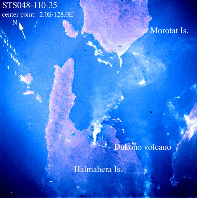 |
Figure 1. Photograph of Dukono taken from the Space Shuttle, 2156 on 15 September 1991. The summit area appears to be covered with ash, and the plume extends ~30 km W from the summit. Courtesy of NASA-SSEOP; photo STS048-110-35. |
Information Contacts: V. Clavel and P. Vetsch, SVG, Switzerland; C. Evans, NASA-SSEOP.
White to light-gray ash cloud reaches 600-1,500 m
A very dense white to light-gray ash cloud from Dukono was reported on 23 June by a commercial aircraft pilot. The cloud was rising ~600-1,500 m above the summit . . . . VSI notes that Dukono is very active, with small eruptions from the main crater almost every day. The height of the eruption column averages 300-600 m above the crater rim. No significant changes in activity have occurred in June or July.
Information Contacts: ICAO; W. Tjetjep, VSI.
Small eruptions prompt aviation notices
NOTAMs issued from the Ujung Pandang aviation control center on 22 November and 1 December 1994 indicated that Dukono was active, but the height of the ash cloud and its direction of drift were unknown. Satellite imagery on 22 November showed cumulus clouds but no evidence of ash. A pilot report from Qantas Airlines on 7 January 1995 described an ash cloud extending to ~6 km altitude and drifting NW, consistent with upper-level wind data; satellite imagery showed no evidence of ash.
Eruptive activity during he first half of 1993 consisted of dark ash clouds, sometimes associated with incandescent fragments (VSI, 1993a). The height of the ash cloud generally varied from 300-600 m above Malupang Magiwe crater . . . .
Information Contacts: BOM Darwin, Australia.
Aviation report of an ash cloud on 30 January
A NOTAM issued from the Ujung Pandang aviation control center on 30 January noted the presence of a volcanic ash cloud from Dukono with both altitude and drift direction unknown. Satellite imagery gave no indication of the presence of volcanic ash, although there was evidence of a low-level smoke plume.
Information Contacts: BOM Darwin, Australia.
Pilot report of plume on 25 September
A pilot report from a Qantas flight on the morning of 25 September described a plume to 6 km altitude that was drifting ESE. Visible satellite imagery failed to detect volcanic ash, but weather clouds in the SE sector were identified with infrared imagery.
Information Contacts: BOM Darwin, Australia.
Infrared satellite data suggest a significant event during August-September 2002
The last reported activity at Dukono consisted of a plume that reached 6 km altitude on 25 September 1995 (BGVN 20:10). Post-May 2000 MODIS data suggested a significant event during 26 August-7 September 2002. During that period, anomalies rose well above alert detection threshold, triggering 10 thermal alerts. All of the alert pixels were located within a 1-km radius.
Information Contacts: Diego Coppola and David A. Rothery, Department of Earth Sciences, The Open University, Milton Keynes, MK7 6AA, UK. Thermal alerts courtesy of the HIGP MODIS Thermal Alerts Team (URL: http://modis.higp.hawaii.edu/).
Ash eruptions in February, June, and July 2003
According to the Volcanological Survey of Indonesia (VSI), Dukono erupted at 0105 on 22 February 2003. A gray-black ash cloud rose to 500 m and drifted E and then S. During 1200-1355 fiery flashes were observed for ~30 minutes, and on 28 February activity returned to normal.
The Darwin VAAC reported that an ash plume was visible on NOAA and GOES 9 imagery beginning on 8 June at 1625. The ash plume reached ~4.5 km altitude and drifted NE. On 9 June ashfall reached the Galela area, as far as 7 km from the summit. Explosive activity decreased, but a blasting sound was still frequent. The Alert Level was set at 2 (on a scale of 1-4). As of 10 June the plume was visible on satellite imagery extending ~75 km N.
During 3-8 July activity preceded by gas emissions from the crater was observed and a gas plume rose 25-75 m. Ash explosions during 9-14 July produced ash columns 800-900 m high, accompanied by a continuous strong blasting sound. Ash fell around the Mamuya and Galela areas. A white-gray ash plume emitted during the week of 15-23 July rose 375 m. On 22 July, an ash explosion from the crater in clear, calm conditions, formed an ash column that reached a maximum height of 1,000 m.
Information Contacts: Volcanological Survey of Indonesia (VSI), Jalan Diponegoro No. 57, Bandung 40122, Indonesia (URL: http://www.vsi.esdm.go.id/); Darwin Volcanic Ash Advisory Centre (VAAC), Bureau of Meteorology, Northern Territory Regional Office, PO Box 40050, Casuarina, NT 0811, Australia (URL: http://www.bom.gov.au/info/vaac/).
Ash explosions in late July through September generate plumes up to 250 m high
Volcanological Survey of Indonesia (VSI) reports for June and July 2003 noted volcanic activity and ash emissions from Dukono. VSI reported an ash explosion commencing on 7 June, with ashfall in the Galela area (~ 7 km from the summit) on 9 June (BGVN 28:06). Explosive events had decreased by 9 June, but as of 10 June the plume was still visible on satellite imagery. No additional activity was reported through the end of June.
Ash explosions were again reported by VSI during 9-23 July, with a maximum plume height of 1,000 m in clear weather on 22 July (BGVN 28:06). No Dukono activity was reported in the report for 21-27 July. Ash explosions were reported again during 28 July-3 August, with a white-gray column, under weak pressure, rising 15-75 m. Some explosions produced dark-gray ash columns reaching 95-450 m high. On 27 and 28 July some blasting sounds were heard in the Galela area and continuous blasting sounds were heard on 25, 26, and 29 July. Minor ash fell around the crater, and ash drifted E, SE, and NE.
Ash explosions continued during 18-31 August, producing a gray ash plume 75 m high and an ash column that rose 200-250 m accompanied by booming sounds. VSI reported that ash explosions during the 1-28 September period produced a gray ash plume 50-200 m high. When there was no explosive activity, white-gray ash emissions were observed rising 50 m from the crater. The hazard status has remained at Alert Level 2 (on a scale of 1-4) since early June.
Information Contacts: Dali Ahmad and Nia Haerani, Volcanological Survey of Indonesia (VSI), Jalan Diponegoro No. 57, Bandung 40122, Indonesia (URL: http://www.vsi.esdm.go.id/).
Nearly continuous explosions, long ash plumes, and local ashfall
Ash explosions during 29 September-19 October rose 50-100 m above the crater. Some of the explosions were accompanied by blasting sounds, and ash fell to the E around the Tobelo area. White-gray ash eruptions continued during 27 October-30 November accompanied by booming sounds, a 100-m-high gray ash column, and more ashfall in the Tobelo area. The hazard status remained at Alert Level 2 (on a scale of 1-4) throughout this period.
The monitoring effort by the Volcanological Survey of Indonesia has been affected by the civil unrest on Halmahera. By 19 November the Dukono observatory had been completely destroyed by the recent "riots," with no idea when it might be rebuilt. Officially there is no longer a VSI officer there, but sometimes two staff check on the volcano. On 18 November they called Bandung with news that activity had increased, with larger, more frequent eruptions (every 5-15 minutes) generating higher plumes. Over the few weeks prior to 18 November eruptive activity has been tending towards bigger explosions, sometimes producing pyroclastic falls and lava flows down to the beach.
Ash plumes from Dukono have been identified in satellite imagery by the Darwin Volcanic Ash Advisory Centre almost every week since early June 2003. Plumes were usually reported rising to altitudes of 3-4.5 km and extending downwind 45-75 km from the summit. Longer plumes to distances of 80-130 km were reported after 18 August. Distinct visual plumes reaching distances of over 200 km were seen in November (figure 2), with a maximum of ~300 km during 12-18 November. Aviation notices continued to be issued through December, warning of almost continuous activity and plumes extending ~90 km from the volcano.
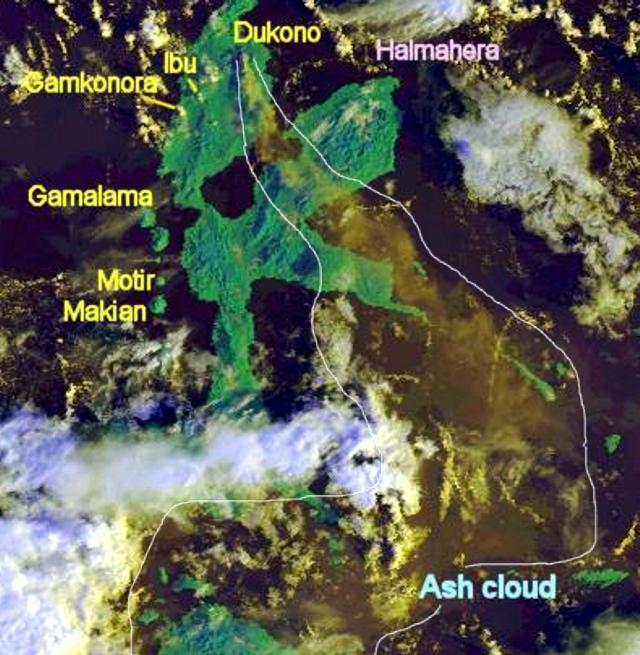 |
Figure 2. Satellite image showing an ash plume extending S and SE from Dukono on 17 November 2003. The volcano is located below the "D" in Dukono, and the approximate extent of the ash cloud has been outlined. Courtesy of Darwin VAAC. |
Paul Taylor provided the following account from Baptist missionary Charles W. Cole. He also noted that the Tobelo "o dukono" just means "(the) volcano," but that the word is now used as a proper name for the volcano on Halmahera. On 16 November 2003 Cole wrote: "The situation in Tobelo continues to be on edge as unknown parties continue to explode bombs. After the distribution of the food packets in Ternate, Kenneth and Oky accompanied the Tobelo pastors on a seven hour ride in a small van to Tobelo. When they arrived in Tobelo it looked like it had just snowed. The ground and all the buildings were covered with white ash. This past week it has rumbled and put out large clouds of white ash. Entire villages and neighborhoods have been destroyed (not by ash)."
Information Contacts: Dali Ahmad, Hetty Triastuty, Nia Haerani, and Suswati, Volcanological Survey of Indonesia (VSI), Jalan Diponegoro No. 57, Bandung 40122, Indonesia (URL: http://www.vsi.esdm.go.id/); Charles W. Cole, Jakarta, Indonesia; Paul W. Taylor, Australian Volcanological Investigations, PO Box 291, Pymble, NSW 2073, Australia; Andrew Tupper, Darwin Volcanic Ash Advisory Centre (VAAC), Commonwealth Bureau of Meteorology, Northern Territory Regional Office, PO Box 40050, Casuarina, NT 0811, Australia (URL: http://www.bom.gov.au/info/vaac/).
December 2003 and January 2004 ash plumes to 3 km altitude extend to 185 km
Satellite imagery for 8 December showed ash plumes at ~ 3 km altitude extending 90-190 km WSW from Dukono. During 10-17 and 24-30 December, thin ash plumes were sometimes visible on satellite imagery extending E to a maximum distance of ~ 90 km. During 31 December to 6 January, low-intensity eruptions at Dukono continued to produce plumes to low levels that extended to ~ 185 km SE.
Information Contacts: Darwin Volcanic Ash Advisory Centre (VAAC), Bureau of Meteorology, Northern Territory Regional Office, PO Box 40050, Casuarina, NT 0811, Australia (URL: http://www.bom.gov.au/info/vaac/).
Continuously erupting volcano with occassional MODIS satellite thermal alerts
Dukono, one of Indonesia's most active volcanoes, erupts nearly continually. Unfortunately, satellite-based thermal alerts from MODVOLC processing and NASA's Terra satellite have thus far only occasionally disclosed Dukono activity. MODVOLC data appear on a dedicated website maintained by the University of Hawaii HIGP MODIS Thermal Alerts team. Coppola and Rothery previously reported a significant thermal event on Dukono during 26 August-7 September 2002 (BGVN 28:03). This was the first sign of Dukono activity indicated by MODVOLC data since the remote-sensing system began data collection in May 2000. Reports from the Volcanological Survey of Indonesia and the Darwin VAAC (BGVN 28:06, 28:09, 28:11, and 28:12) documented ash eruptions during February and June 2003, with activity continuing to at least January 2004.
An updated analysis of MODVOLC data for the observational period August 2000-April 2004 included thermal alerts from NASA's Aqua satellite. Alerts were triggerd for 26 August and 6 and 7 September 2002. They confirmed the August-September 2002 event, but found very little sign of subsequent activity through the end of April 2004. After September 2002 the only thermal alerts were single pixel events only slightly above the MODVOLC detection threshold. They took place on 1 March and 10 November 2003. Inspection of raw MODIS data revealed an additional anomaly on 17 November 2003, but the alert ratio was slightly below the MODVOLC detection threshold.
For an explanation of MODVOLC anomalies see BGVN 28:01 or the MODVOLC website. The scarcity of thermal alerts at Dukono, despite the recurrent ash eruptions, indicates the general invisibility (or small size) of any hot feature(s) there. Small to moderate sized ash columns would be unlikely to trigger an alert since they occur in a narrow time window.
Information Contacts: MODIS Thermal Alerts team, Hawaii Institute of Geophysics and Planetology (HIGP), School of Ocean and Earth Science and Technology, University of Hawaii at Manoa (URL: http://modis.hgip.hawaii.edu/); David A . Rothery and Charlotte Saunders, Department of Earth Sciences, The Open University, Milton Keynes, MK7 6AA, United Kingdom.
Despite ongoing volcanism, a paucity of MODVOLC thermal alerts after 2002
Based on MODVOLC thermal alert data, Coppola and Rothery had previously reported a significant thermal event during 26 August-7 September 2002 (BGVN 28:03). This was the first sign of activity at Dukono since the inception of MODVOLC data in May 2000. Subsequent reports from the Volcanological Survey of Indonesia and the Darwin VAAC (BGVN 28:06, 28:09, and 28:11) documented ash eruptions in February and June-December 2003.
An updated analysis of MODVOLC data covering the period August 2000-April 2004 confirmed the August-September 2002 event by the addition of thermal alerts from NASA's Aqua satellite (26 August, 6 and 7 September 2002), but found very little sign of activity subsequently throughl the end of April 2004. During the whole period since September 2002 the only thermal alerts were single-pixel events, only slightly above the MODVOLC detection threshold, on 1 March and 10 November 2003. Inspection of raw MODIS data revealed an additional anomaly on 17 November 2003 with an alert ratio slightly below the MODVOLC detection threshold. The scarcity of thermal alerts at Dukono despite recurrent ash eruptions indicated the general invisibility (or small size) of any hot feature at the source, such as an incandescent vent or lava dome.
Data acquisition and analysis. Reports from Diego Coppola and David A. Rothery provided analyses of MODIS thermal alerts during 2001 and 2002 (using the MODVOLC alert-detection algorithm) extracted from the MODIS Thermal Alerts website (http://modis.hgip.hawaii.edu/) maintained by the University of Hawaii HIGP MODIS Thermal Alerts team (BGVN 28:01). Rothery and Charlotte Saunders provided updates to 31 May 2004. MODVOLC data are now routinely available from the Aqua satellite (equator crossing times 0230 and 1430 local time) in addition to the original Terra satellite (equator crossing times 1030 and 2230 local time).
Information Contacts: David A. Rothery and Charlotte Saunders, Department of Earth Sciences, The Open University, Milton Keynes, MK7 6AA, United Kingdom.
Ongoing emissions continue during 2004-2005 in decades-long eruption
During 2004 and 2005, Dukono continued to emit ash plumes as it has for many decades. This report first summarizes available reports from Indonesia's Center of Volcanology and Geological Hazard Mitigation (CVGHM).
David Rothery and Charlotte Saunders previously discussed MODIS thermal alerts up to April 2004 in our last report (BGVN 29:06). Since that time, and as recently as 1 August 2006, the only MODIS thermal alerts were detected on 4 October 2004.
CVGHM observations, 2004-2005. During this interval, the volcano's hazard status stood at Level 2 (Yellow).
During 31 May to 31 August 2004 small explosions were accompanied by rumbling sounds and the release of white to gray-black ash. The emissions occurred at a relatively constant frequency and intensity. The ash-bearing clouds reached up to ~ 500 m above the summit. Ash discharges and rumbling were constant.
Eruptive behavior continued throughout 2005. From 24 to 30 January explosions often ejected ash, and dark gray ash plumes reached 200-600 m above the summit. On 9 May an ash eruption was accompanied by an explosive sound repeated 27 times. Ejections the week of 26 September-2 October contained ash and, occasionally, larger pyroclastic material. Explosions occurred about 15 times a day, sending plumes 100-400 m high. Thousands of explosions were documented during the next two weeks (table 1). Ash columns rose 100-950 m above the summit.
Table 1. Summary of types and numbers of seismic/volcanic events occurring at Dukono during late September through mid-October 2005. Courtesy of CVGHM.
| Dates | A-type | B-type | Explosions | Tectonic |
| 26 Sep-02 Oct 2005 | 27 | 18 | 146 | 22 |
| 03 Oct-09 Oct 2005 | 42 | 32 | 1,471 | 5 |
| 10 Oct-16 Oct 2005 | 10 | 1 | 2,068 | 3 |
Aviation reports, 2004-2006. A large table contains aviation observations from 31 December 2003 through 12 January 2006 from the Darwin VAAC (table 2), although not all the VAAC's original reports were inspected. Some of the reported eruptions during that time generated plumes visible on satellite imagery to distances as far as 200 km. Plumes often rose to ~ 3 km altitude.
Table 2. Events reported for Dukono for the interval 31 December 2003-12 January 2006 (as taken from summaries of collaborative Darwin VAAC and CVGHM reports presented in USGS-Smithsonian Weekly Reports). Courtesy of Darwin VAAC and CVGHM.
| Dates | Event(s) | Plume characteristics (heights above sea level) |
| 31 Dec 2003-06 Jan 2004 | low-intensity eruptions | low levels, extended to ~185 km SE |
| 07 Jan 2004-13 Jan 2004 | low-intensity eruptions | low levels, extended to ~120 km SSW |
| 20 Feb 2004-22 Feb 2004 | -- | thin ash plumes visible on satellite, extended predominately E to max. of 90 km |
| 25 Feb 2004-27 Feb 2004 | -- | thin ash plumes visible on satellite, extended max. of 160 km E at height of ~3 km |
| 14 Mar 2004 | -- | ash plume visible on satellite imagery at height of ~4.6 km, extended SE |
| 17 Mar 2004-01 Jun 2004 | -- | ash plumes sometimes visible on satellite imagery reaching max. height of ~3 km; on 24 Mar one plume extended ~185 km E |
| 07 Jun 2004 | -- | thin ash plume visible in satellite imagery extended ~75 km ESE at ~3 km |
| 08 Jun 2004 | -- | thin ash plume seen in satellite imagery extended ~65 km ESE at altitude of ~2 km |
| 09 Jun 2004-15 Jun 2004 | -- | low-level plumes occasionally emitted, visible on satellite imagery |
| 01 Sep 2004 | -- | thin ash plume visible on satellite imagery at height of ~3 km, drifting NW |
| 26 Sep 2004 | eruption | satellite imagery showed plume extended WNW at a height of ~3 km |
| 24 Jan 2005-30 Jan 2005 | ash explosions | ash plumes rose 200-600 m above summit |
| 21 May 2005 | -- | satellite data showed thin ash plumes; height not reported |
| 29 May 2005-31 May 2005 | -- | small low-level ash plumes visible on satellite imagery |
| 01 and 04 Jun 2005 | -- | ash plumes visible on satellite imagery |
| 20 Jun 2005-21 Jun 2005 | -- | ash visible on satellite imagery, drifting NW; height not reported |
| 02 Sep 2005 | -- | plume observed on satellite imagery, height of ~3 km, extended NW |
| 26 Sep 2005-09 Oct 2005 | explosive activity | ash rose 100-950 m above the summit and mostly drifted ENE |
| 10 Oct 2005-16 Oct 2005 | explosions, pyroclastic ejections | ash columns rose 100-950 m above summit and mainly drifted SE |
| 19 Oct 2005 | -- | thin low-level plume visible on satellite imagery extended to the ENE |
| 27 Oct 2005 | -- | ash plume visible on satellite imagery extended to NNW |
| 12 Jan 2006 | -- | ash visible on satellite imagery at height of ~3 km, extended SW |
Information Contacts: Center of Volcanology and Geological Hazard Mitigation (CVGHM), Jalan Diponegoro 57, Bandung 40122, Indonesia (URL: http://www.vsi.esdm.go.id/); Darwin Volcanic Ash Advisory Center (VAAC) (URL: http://www.bom.gov.au); HIGP Thermal Alerts Team, Hawai'i Institute of Geophysics and Planetology (HIGP) / School of Ocean and Earth Science and Technology (SOEST), University of Hawai'i, 2525 Correa Road, Honolulu, HI 96822, USA (URL: http://modis.higp.hawaii.edu/).
Inferred ash plume on 5 December 2006
Situated on Halmahera Island in northern Indonesia, Dukono released an ash plume 5 December 2006. The Moderate Resolution Imaging Spectroradiometer (MODIS) flying onboard NASA's Terra satellite captured the 5 December plume (figure 3) drifting E away from meteorological clouds. NASA affiliate Jesse Allen has interpreted the plume as ash bearing.
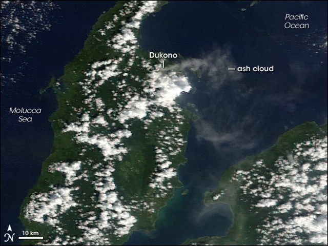 |
Figure 3. Inferred ash plume of Dukono volcano streaming E and then S on 5 December 2006. NASA image created by Jesse Allen, Earth Observatory, using data provided courtesy of the MODIS Rapid Response team. |
As of early 2007, the Darwin Volcanic Ash Advisory Center (VAAC) reported that plumes from Dukono were visible on satellite imagery several times during 2006, and once in January 2007 (see table 3). Satellite images suggested modest successive plumes with ash concentrations varying from diffuse to dense.
Table 3. Summary of plumes reported from Dukono, January 2006-January 2007. Courtesy of the Darwin VAAC.
| Date | Plume top (altitude) | Plume drift direction | Comment |
| 12 Jan 2006 | 3 km | SW | ash |
| 23 Aug 2006 | -- | NNE | diffuse ash |
| 05 Dec 2006 | 3 km | ENE | ash |
| 22 Dec 2006 | -- | SE | diffuse ash |
| 16 Jan 2007 | -- | SSE | diffuse |
Thermal anomalies were detected by MODIS (table 4) on 13 December 2006 and then on four days in February 2007. These were the first anomalies detected by the MODVOLC system since October 2004 (BGVN 31:06).
Table 4. Thermal anomalies at Dukono based on MODIS-MODVOLC retrievals and processing from October 2004 through February 2007. Courtesy of Hawai'i Institute of Geophysics and Planetology Thermal Alerts System.
| Date (UTC) | Time (UTC) | Pixels | Satellite |
| 04 Oct 2004 | 1350 | 2 | Terra |
| 13 Dec 2006 | 1350 | 1 | Terra |
| 13 Feb 2007 | 1405 | 1 | Terra |
| 13 Feb 2007 | 1700 | 1 | Aqua |
| 15 Feb 2007 | 1350 | 1 | Terra |
| 18 Feb 2007 | 1715 | 1 | Aqua |
| 24 Feb 2007 | 1345 | 1 | Terra |
Information Contacts: Center of Volcanology and Geological Hazard Mitigation (CVGHM), Jalan Diponegoro 57, Bandung 40122, Indonesia (URL: http://www.vsi.esdm.go.id/); Darwin Volcanic Ash Advisory Center (VAAC), Bureau of Meteorology, Darwin, Australia (URL: http://www.bom.gov.au/); Hawai'i Institute of Geophysics and Planetology (HIGP) Thermal Alerts System, School of Ocean and Earth Science and Technology (SOEST), Univ. of Hawai'i, 2525 Correa Road, Honolulu, HI 96822, USA (URL: http://modis.higp.hawaii.edu/).
Early 2007 ash plume and occasional thermal anomalies
Our last Dukono report discussed an ash plume on 5 December 2006 (BGVN 32:01). During the time period of this report, 1 January through mid-April 2007, the Darwin Volcanic Ash Advisory Centre (VAAC) detected a small plume on satellite imagery on 16 January 2007 that lacked clear ash content.
The 16 January plume was imaged using data from two satellites (DMSP and MTSAT-1R). The Darwin VAAC's ash advisory noted a low-level plume blowing to the SSE on an image taken at 2233 on 15 January (time and date in terms of UTC; 0733 on 16 January local time).
Table 5 contains a list of thermal anomalies detected from MODIS satellites by the Hawai'i Institute of Geophysics and Planetology (HIGP) Thermal Alerts System during the first four months of 2007. There were two alerts on 13 February followed by one alert on the respective days 15, 18, and 24 February and 8 March.
Table 5. Thermal anomalies at Dukono based on MODIS-MODVOLC retrievals and processing for the interval 1 January through April 2007. Courtesy of Hawai'i Institute of Geophysics and Planetology (HIGP) Thermal Alerts System.
| Date (UTC) | Time (UTC) | Pixels | Satellite |
| 13 Feb 2007 | 1405 | 1 | Terra |
| 13 Feb 2007 | 1700 | 1 | Aqua |
| 15 Feb 2007 | 1350 | 1 | Terra |
| 18 Feb 2007 | 1715 | 1 | Aqua |
| 24 Feb 2007 | 1345 | 1 | Terra |
| 08 Mar 2007 | 1410 | 1 | Terra |
Information Contacts: Center of Volcanology and Geological Hazard Mitigation (CVGHM), Jalan Diponegoro 57, Bandung 40122, Indonesia (URL: http://vsi.esdm.go.id/); Darwin Volcanic Ash Advisory Centre (VAAC), Bureau of Meteorology, Northern Territory Regional Office, PO Box 40050, Casuarina, NT 0811, Australia (URL: http://www.bom.gov.au/info/vaac/); Hawai'i Institute of Geophysics and Planetology (HIGP) Thermal Alerts System, School of Ocean and Earth Science and Technology (SOEST), University of Hawai'i, 2525 Correa Road, Honolulu, HI 96822, USA (URL: http://modis.higp.hawaii.edu/).
Thermal anomalies indicate possible activity at Dukono in October 2007
Based on visual observations, the Center of Volcanology and Geological Hazard Mitigation (CVGHM) reported that during the week of 18-25 June 2007 white-gray ash rose to 50-250 m above the summit. The hazard status of the volcano remained on level 2 (on a scale of 1-4).
No significant change of seismicity was noted with respect to previous weeks, and no thermal anomalies were measured during that week by the MODIS/MODVOLC satellite team (table 6). Subsequently, a sequence of thermal anomalies were measured by satellite between 10 August and 27 October 2007.
Table 6. Thermal anomalies at Dukono based on MODIS-MODVOLC imaging between 9 March 2007 and 27 November 2007 (continued from the list in BGVN 32:03). Courtesy of Hawai'i Institute of Geophysics and Planetology (HIGP) Thermal Alerts System.
| Date (UTC) | Time (UTC) | Pixels | Satellite |
| 09 Mar-09 Aug 2007 | -- | 0 | -- |
| 10 Aug 2007 | 1645 | 1 | Aqua |
| 27 Sep 2007 | 1350 | 1 | Terra |
| 02 Oct 2007 | 1705 | 1 | Aqua |
| 04 Oct 2007 | 1355 | 1 | Terra |
| 04 Oct 2007 | 1650 | 1 | Aqua |
| 11 Oct 2007 | 1405 | 1 | Terra |
| 13 Oct 2007 | 1350 | 1 | Terra |
| 13 Oct 2007 | 1645 | 2 | Aqua |
| 16 Oct 2007 | 1715 | 1 | Aqua |
| 18 Oct 2007 | 1410 | 2 | Terra |
| 18 Oct 2007 | 1705 | 1 | Aqua |
| 27 Oct 2007 | 1655 | 1 | Aqua |
| 28 Oct-27 Nov 2007 | -- | 0 | -- |
Information Contacts: Center of Volcanology and Geological Hazard Mitigation (CVGHM), Jalan Diponegoro 57, Bandung 40122, Indonesia (URL: http://vsi.esdm.go.id/); Hawai'i Institute of Geophysics and Planetology (HIGP) Thermal Alerts System, School of Ocean and Earth Science and Technology (SOEST), University of Hawai'i, 2525 Correa Road, Honolulu, HI 96822, USA (URL: http://modis.higp.hawaii.edu/).
Thermal hotspots and ash plumes continue
Thermal anomalies at Dukono were reported on nine days between 10 August and 27 October 2007 and an ash plume occurred in June 2007 (BGVN 32:10). This report discusses activity from late November 2007 through early October 2008.
MODIS-MODVOLC thermal alerts were recorded on 12 December 2007 and 31 January 2008. Between 31 March and 24 April 2008 the Center of Volcanology and Geological Hazard Mitigation (CVGHM) reported incandescence at the summit. On 25 April, incandescent material was ejected 25 m above the summit. Seismicity increased during 30 April-2 May.
On 25 May, an ash plume rose to an altitude of 1.4-2.1 km and was accompanied by thunderous and booming sounds. An ash plume on 29 May rose to an altitude of 2.3 km and again was accompanied by thunderous and booming sounds. The Alert Level was raised to 3 (on a scale of 1-4). Residents and visitors were not permitted within 3 km of the summit. Satellite imagery detected hotspots through 26 May 2008 (table 7).
Table 7. Thermal anomalies at Dukono based on MODIS-MODVOLC imaging between 27 November and 6 October 2008 (continued from the lists in BGVN 32:03 and 32:10). Courtesy of Hawai'i Institute of Geophysics and Planetology (HIGP) Thermal Alerts System.
| Date (UTC) | Time (UTC) | Pixels | Satellite |
| 12 Dec 2007 | 1710 | 1 | Aqua |
| 31 Jan 2008 | 1700 | 1 | Aqua |
| 06 Apr 2008 | 1645 | 1 | Aqua |
| 17 Apr 2008 | 1330 | 1 | Terra |
| 06 May 2008 | 1700 | 1 | Aqua |
| 26 May 2008 | 1340 | 1 | Terra |
| 26 May 2008 | 1635 | 2 | Aqua |
According to the CVGHM, during 30 May-12 June, seismicity decreased and white plumes were observed at altitudes of 1.4-1.8 km when clouds did not inhibit observations. Because of decreased seismic activity, on 13 June the Alert Level was decreased to 2. Residents and visitors were not permitted within 2 km of the summit.
No further reports were issued by CVGHM through 6 October 2008. However, the Darwin Volcanic Ash Advisory Centre reported that satellite imagery had detected ash plumes during 25 July-6 October (table 8).
Table 8. Ash plumes reported from Dukono during 25 July-6 October 2008 (UTC). Data from the Darwin Volcanic Ash Advisory Centre.
| Date (UTC) | Plume Altitude | Plume Direction |
| 25-27 Jul 2008 | 3 km | W |
| 19 Aug 2008 | 2.4 km | W |
| 24 Aug 2008 | 2.7 km | NW |
| 26 Aug 2008 | 1.5 km | W, WNW |
| 02 Sep 2008 | Low-level (not specified) | WNW |
| 10 Sep 2008 | -- | SW |
| 11 Sep 2008 | 1.5 km | NW |
| 12 Sep 2008 | 1.5 km | NW |
| 23 Sep 2008 | 1.8 km | NE |
| 24 Sep 2008 | 1.8 km | NE |
Information Contacts: Darwin Volcanic Ash Advisory Centre (VAAC), Bureau of Meteorology, Northern Territory Regional Office, PO Box 40050, Casuarina, NT 0811, Australia (URL: http://www.bom.gov.au/info/vaac/); Center of Volcanology and Geological Hazard Mitigation (CVGHM), Jalan Diponegoro 57, Bandung 40122, Indonesia (URL: http://vsi.esdm.go.id/); Hawai'i Institute of Geophysics and Planetology (HIGP) Thermal Alerts System, School of Ocean and Earth Science and Technology (SOEST), University of Hawai'i, 2525 Correa Road, Honolulu, HI 96822, USA (URL: http://modis.higp.hawaii.edu/).
Ongoing minor ash plumes through at least 9 January 2009
Thermal hotspots and minor ash plumes were reported through September and early October 2008 (BGVN 33:08). Dukono continued to emit minor ash plumes from early October 2008 through 9 January 2009, although MODVOLC thermal alerts have been absent since 26 May 2008. Five instances of ash plumes were noted from 11 October 2008 to 9 January 2009, as recorded by the Darwin Volcanic Ash Advisory Centre (table 9). None of the plumes rose above 3 km altitude.
Table 9. Ash plumes reported from Dukono between 11 October 2008 and 9 January 2009 (UTC). Data from the Darwin Volcanic Ash Advisory Centre.
| Date (UTC) | Plume Altitude | Plume Direction | Plume Distance |
| 11 Oct 2008 | 3 km | WNW | ~110 km |
| 06-07 Nov 2008 | 2.4 km | WNW | ~72 km |
| 20 Nov 2008 | 3 km | NW | ~110 km |
| 15 Dec 2008 | 3 km | SE | ~160 km |
| 06 Jan 2009 | 1.8 km | E | ~90 km |
Information Contacts: Darwin Volcanic Ash Advisory Centre (VAAC), Bureau of Meteorology, Northern Territory Regional Office, PO Box 40050, Casuarina, NT 0811, Australia (URL: http://www.bom.gov.au/info/vaac/); Center of Volcanology and Geological Hazard Mitigation (CVGHM), Jalan Diponegoro 57, Bandung 40122, Indonesia (URL: http://vsi.esdm.go.id/); Hawai'i Institute of Geophysics and Planetology (HIGP) Thermal Alerts System, School of Ocean and Earth Science and Technology (SOEST), University of Hawai'i, 2525 Correa Road, Honolulu, HI 96822, USA (URL: http://modis.higp.hawaii.edu/).
Intermittent ash plumes from January 2009 through May 2010
Minor ash plumes had continued to be intermittently reported from this long-active volcano during October 2008-January 2009 (BGVN 33:11). The Darwin VAAC has provided continuous monitoring of the activity through satellite surveillance (table 10).
Table 10. Ash plumes reported from Dukono between 7 January 2009 and 30 May 2010 (UTC). Data from the Darwin Volcanic Ash Advisory Centre.
| Date (UTC) | Plume Altitude | Plume Direction | Plume Distance |
| 07 Jan 2009 | 1.8 km | E and SE | -- |
| 18 Jan 2009 | 3 km | NE and N | -- |
| 09-11 Feb 2009 | 3 km | E and SE | -- |
| 12 Apr 2009 | 3 km | NW | 55 km |
| 28 Apr 2009 | 4.5 km | E | 150 km |
| 29 Apr-04 May 2009 | 3.7-4.5 km (pilot report) | E and NE | 45-165 km |
| 05-07 May 2009 | 3-3.7 km | SE | 20-110 km |
| 14 May 2009 | 3 km | N | 110 km |
| 26 May 2009 | 3 km | N | 90 km |
| 27-28 May 2009 | 3 km | NE | 55-110 km |
| 06-08 Jun 2009 | ? | NW and N | 20-75 km |
| 16 Jun 2009 | 1.5 km | NE | 40 km |
| 28 Jun 2009 | 2.4 km | N | 75 km |
| 05 Jul 2009 | 2.4 km | E | 65 km |
| 07-08 Jul 2009 | 2.4 km | NE | 85 km |
| 06-07, 10 Aug 2009 | 2.4-3 km | NE | 45-130 km |
| 15 Aug 2009 | 3 km | NW | 90 km |
| 26 Aug-01 Sep 2009 | 2.1 km | NE | 20-65 km |
| 07-08 Sep 2009 | 2.1 km | E and SE | 35-75 km |
| 12, 14 Sep 2009 | 2.4 km | W and SW | 25-75 km |
| 17-20 Sep 2009 | 2.4 km | NE and ESE | 25-75 km |
| 24 Sep 2009 | 2.4 km | NW | 65 km |
| 02 Oct 2009 | 2.7 km | NE | 75 km |
| 06 Oct 2009 | 3 km | NE | 55 km |
| 07 Oct 2009 | 3 km | NW | 74 km |
| 15 Oct 2009 | 2.4 km | NW | 45 km |
| 22-23, 26-27 Oct 2009 | 2.1-2.4 km | NE and E | 45-95 km |
| 31 Oct 2009 | 1.5 km | NE and N | 35-110 km |
| 08 Nov 2009 | 3 km | NW | 35 km |
| 30 Nov 2009 | 3 km | E | 75 km |
| 05-06 Dec 2009 | 3 km | E and SE | 55-85 km |
| 09-11 Dec 2009 | 3 km | E and SE | 90-130 km |
| 05-06, 10 Feb 2010 | 2.4 km | SW and W | 55-150 km |
| 13 Mar 2010 | 2.7 km | E | 75 km |
| 22 Mar 2010 | 2.4 km | SE | 45 km |
| 02 Apr 2010 | 2.4 km | S | 55 km |
| 09 Apr 2010 | 3.7 km | NE | 220 km |
| 10-12 Apr 2010 | 1.5-2.1 km | NE | 20-75 km |
| 27 Apr 2010 | 3 km | NW | 45 km |
| 03 May 2010 | 3 km | W | 90 km |
| 04 May 2010 | 3 km | NW, NE, SE | 25-100 km |
| 06 May 2010 | 4.6 km (pilot report) | NW | -- |
| 08-10 May 2010 | 3 km | NW, NE, SE | 25-100 km |
| 16 May 2010 | 3 km | W | 165 km |
| 18 May 2010 | 3 km | NW | 165 km |
Dukono's visible plume was almost continuous between January 2009 and February 2010 with only two short periods of quiescence for about eight weeks between mid-February and mid-April 2009 and eight weeks from 11 December 2009 to 5 February 2010. Three periods of relatively stronger activity occurred in late April through 28 May 2009 and created ash plumes that drifted the greatest distances, 110-150 km. A higher level of activity occurred again in early to mid-August and in early December 2009 just before the second period of reduced activity. Two recent MODVOLC thermal alerts occurred on 30 May 2010; they were detected on both the Terra and Aqua satellites.
Information Contacts: Darwin Volcanic Ash Advisory Centre (VAAC), Bureau of Meteorology, Northern Territory Regional Office, PO Box 40050, Casuarina, NT 0811, Australia (URL: http://www.bom.gov.au/info/vaac/); Center of Volcanology and Geological Hazard Mitigation (CVGHM), Jalan Diponegoro 57, Bandung 40122, Indonesia (URL: http://vsi.esdm.go.id/); Hawai'i Institute of Geophysics and Planetology (HIGP) Thermal Alerts System, School of Ocean and Earth Science and Technology (SOEST), University of Hawai'i, 2525 Correa Road, Honolulu, HI 96822, USA (URL: http://modis.higp.hawaii.edu/).
Intermittent weak ash plumes persist through 4 April 2011
Dukono has generated intermittent minor ash plumes since before July 2008 (BGVN 33:08, 33:11, 35:04). The Darwin Volcanic Ash Advisory Centre (VAAC) has provided satellite surveillance. Table 11 extends the table of ash plumes presented in BGVN 35:04 through 4 April 2011.
Table 11. Ash plumes reported from Dukono between 30 May 2010 and 4 April 2011, based on data from the Darwin Volcanic Ash Advisory Centre. Each date or date range represents at least one plume.
| Date (UTC) | Plume Altitude | Plume Direction | Plume Distance |
| 02 Jun 2010 | 2.4 km | NW | 110 km |
| 07 Jun 2010 | 3 km | W | 110 km |
| 09-10 Jun 2010 | -- | W | 130 km |
| 18-20 Jun 2010 | 2.4 km | W | 120 km |
| 23-24 Jun 2010 | 2.4 km | W | 120-225 km |
| 29 Jun 2010 | 2.4 km | W | 120-225 km |
| 30 Jun-02 Jul 2010 | 2.4 km | W, NW | 90-225 km |
| 06 Jul 2010 | 2.4 km | W, NW | 90-225 km |
| 07 Jul 2010 | 2.4 km | N, NW | 35-75 km |
| 09-10 Jul 2010 | 2.4 km | N, NW | 35-75 km |
| 24 Jul 2010 | 3 km | W | 110 km |
| 31 Jul 2010 | 3 km | W | 90 km |
| 03 Aug 2010 | 3 km | NNE | 130 km |
| 12-22 Aug 2010 | 3 km | W, NW, SW | 25-225 km |
| 25-29 Aug 2010 | 2.1-3 km | W, NE | 35-110 km |
| 01-02 Sep 2010 | 2.4 km | W, NW | 95 km |
| 06-11 Sep 2010 | 2.4 | W, NW, SW | 35-95 km |
| 14-18 Sep 2010 | 2.4 km | W, NW, SW | 35-260 km |
| 20-25 Sep 2010 | 2.4 km | W, NW | 35-260 km |
| 01-04 Oct 2010 | 2.4 km | W, NW | 55-205 km |
| 06-07 Oct 2010 | 2.4 km | W | 75-110 km |
| 01-02 Nov 2010 | 3 km | NW, SW | 45-75 km |
| 23-27 Nov 2010 | 2.4 km | W | 75-130 km |
| 03-05 Dec 2010 | 3 km | W | 55-110 km |
| 21 Dec 2010 | 2.7 km | NW | 55 km |
| 05-07 Jan 2011 | 2.4-3.7 km | W | 65-130 km |
| 11 Feb 2011 | 2.4 km | N | 75 km |
| 16-17 Feb 2011 | 3 km | W, SW | 150-185 km |
| 11-12 Mar 2011 | 2.1 km | SW | 110-165 km |
| 18-19 Mar 2011 | 2.1 km | N, NW, NE | 37-75 km |
| 04 Apr 2011 | 2.4 km | E | 185 km |
During the reporting period (1 June 2010- 4 April 2011), there were four thermal alerts derived from the Hawai'i Institute of Geophysics and Planetology Thermal Alerts System (MODVOLC). They were on 1 and 10 September and 6 and 20 November 2010.
Arnold Binas uploaded photos and video showing Dukono ongoing ash emissions during late January 2010 (Binas, 2010, 2011). The video takes the form of an excursion from an adjacent settlement, approach to the volcano, and finally some shots taken at the crater rim. In addition, he posted several still photos of Dukono on Flickr (Binas, 2010). The photo titled "Inside the Dukono crater" noted frequent pulses of ash rising from the crater and his 6 hours on the crater rim led to only one partial view into the crater interior.
References. Binas, A., 2011, Halmahera ? Dukono Volcano 2010, YouTube (URL: http://www.youtube.com/watch?v=NqMax2hqxMo).
Binas, A., 2010, Indonesian volcanoes 2010, hshdude photostream, Flickr (URL: http://www.flickr.com/photos/hshdude/sets/72157623718033396).
Information Contacts: Darwin Volcanic Ash Advisory Centre (VAAC), Bureau of Meteorology, Northern Territory Regional Office, PO Box 40050, Casuarina, NT 0811, Australia (URL: http://www.bom.gov.au/info/vaac/); Hawai'i Institute of Geophysics and Planetology (HIGP) MODVOLC Thermal Alerts System, School of Ocean and Earth Science and Technology (SOEST), Univ. of Hawai'i, 2525 Correa Road, Honolulu, HI 96822, USA (URL: http://modis.higp.hawaii.edu/); Arnold Binas (aka, hshdude), Australia.
Continued frequent minor ash plume at least as late as 13 September 2011
Frequent minor ash plumes have occurred at Dukono (see figure 4) since before July 2008 (BGVN 33:08, 33:11, 35:04, and 36:03). This report covers the time period subsequent to our previous report, which ended on 4 April 2011 (BGVN 36:03), through 13 September 2011. The Darwin Volcanic Ash Advisory Centre (VAAC) has provided continuous monitoring of the activity through satellite surveillance (table 12) during this time period.
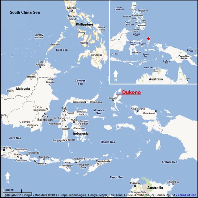 |
Figure 4. Map showing Dukono volcano, on the island of Halmahera, Indonesia. Courtesy of Google Maps (prepared by GVP editor Jeff Jessens). |
Table 12. Ash plumes from Dukono detected in satellite images between 21 April 2011 and 13 September 2011. Each date or date range represents at least one plume. No plumes were reported between the end of the table in our previous report (4 April 2011) and 21 April 2011. Data from the Darwin Volcanic Ash Advisory Centre.
| Date (UTC) | Plume Altitude | Plume Direction | Plume Distance |
| 21 Apr-22 Apr 2011 | 2.1 km | NE and E | Up to 85 km |
| 28 Apr-02 May 2011 | 4.3 km | NW, W, and SW | 55-150 km |
| 10 May-12 May 2011 | 4.3 km | NE and E | 75-110 km |
| 16 May 2011 | 3 km | E | Over 90 km |
| 19 May 2011 | 3 km | NE | 110 km |
| 01 Jun 2011 | 3 km | NE | 110 km |
| 01 Jul 2011 | 3 km | E | 110 km |
| 06 Jul-07 Jul 2011 | 3 km | NW | 55 km |
| 11 Aug 2011 | 3 km | Various | 14-93 km |
| 14 Aug 2011 | 3 km | NW | 93 km |
| 18 Aug-21 Aug 2011 | 3 km | N and NE | 110-150 km |
| 13 Sep 2011 | 3 km | NW | 75 km |
According to a news article (Metro TV News), seismic activity increased in August 2011. On 11 August, ash explosions were audible within a radius of about 7 km from the base of the volcano. Ash was ejected as high as 1 km above the crater, producing plumes that drifted E and S, and also approached Tobelo City (14 km ENE). The news article noted that seismographs at the Dukono observation post had recorded more than 100 eruption earthquakes during this time.
A news report posted on the web (YouTube, 2011) discussed an eruption at Dukono during first half of September 2011. The commentator spoke in Indonesian. The video shows a large column of ash rising what appears to be on the order of one or a few kilometers above the crater. This news report was discussed elsewhere as well on the web.
During this reporting period (21 April 2011 to 13 September 2011), there were no thermal alerts derived from the Hawai'i Institute of Geophysics and Planetology Thermal Alerts System (MODVOLC). The most recent MODVOLC thermal alert was on 20 November 2010.
Reference. YouTube (2011), Gunung Dukono letusan, Leputan 6.com, uploaded by szbrnr on 7 September 2011 (URL: http://www.youtube.com/watch?v=mb3We1MwXdg).
Information Contacts: Darwin Volcanic Ash Advisory Centre (VAAC), Bureau of Meteorology, Northern Territory Regional Office, PO Box 40050, Casuarina, NT 0811, Australia (URL: http://www.bom.gov.au/info/vaac/); Center of Volcanology and Geological Hazard Mitigation (CVGHM), Jalan Diponegoro 57, Bandung 40122, Indonesia (URL: http://vsi.esdm.go.id/); Hawai'i Institute of Geophysics and Planetology (HIGP) Thermal Alerts System, School of Ocean and Earth Science and Technology (SOEST), University of Hawai'i, 2525 Correa Road, Honolulu, HI 96822, USA (URL: http://modis.higp.hawaii.edu/); Metro TV News (URL: http://www.metrotvnews.com).
Frequent minor ash plumes persist at least through July 2014
Dukono, one of Indonesia's most active volcanoes, frequently ejects weak ash plumes, and our previous report summarized that activity through 13 September 2011 (BGVN 36:03). This report summarizes activity from that date through July 2014. Most of the data in this report come from the Darwin Volcanic Ash Advisory Centre (VAAC), which monitors activity through satellite remote sensing. The volcano has been in a state of near-continuous eruption since 1933. A map showing the location of Dukono can be found in BGVN 36:08.
Activity at Dukono through the reporting period was characterized by frequent weak explosions that ejected ash to altitudes usually in the range of 2.1-3 km (table 13, figure 5). Stronger explosions occurred occasionally, sending plumes to altitudes as high as 4.5 km. According to Darwin VAAC management reports, the VAAC issued 271 ash advisories for Dukono between July 2011-December 2012 and 116 advisories between January and November 2013.
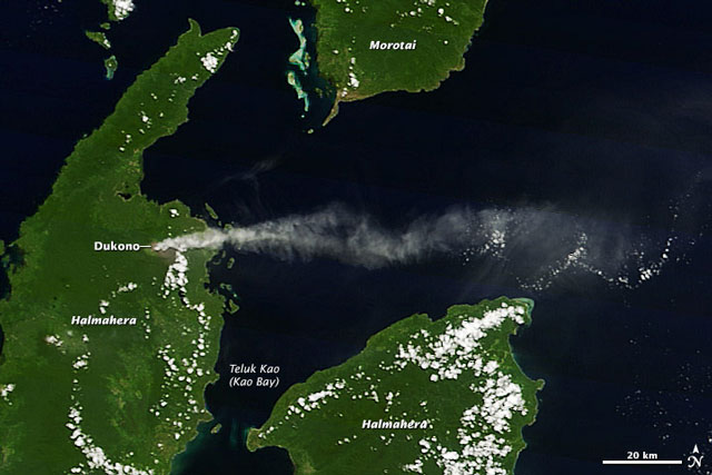 |
Figure 5. Natural color photo taken on 28 April 2014 of an ash plume from Dukono. According to Darwin VAAC, this plume was blown 65-280 km E. Image was captured by the Moderate Resolution Imaging Spectroradiometer (MODIS) on the Terra satellite. Courtesy of NASA's Earth Observatory (Jeff Schmaltz). |
MODVOLC thermal alerts for the reporting period are indicated in table 14. No alerts were issued between 14 September 2011 and 27 May 2012. The MODVOLC data indicate that the period 31 May-18 June 2012 was especially active. This is also partially reflected by the greater altitudes reached by the ash plumes during this period (table 13). The number of thermal alerts was also greater during 26 September-1 October 2012; however, the number of plumes or their heights during this period did not reflect greater volcanic activity.
Table 13. Ash plumes from Dukono based on analyses of satellite imagery and wind data between 14 September 2011 and 17 July 2014. Each date or date range represents at least one plume. The table excludes data on numerous plumes between 30 June 2012 and 28 August 2013. Source data came aviation reports (VAAs) reported by the Darwin Volcanic Ash Advisory Centre.
| Date (UTC) | Plume Altitude (km) | Plume Direction | Plume Distance |
| 2011 Sep 27 | 2.1 | NW | 75 km |
| 2011 Oct 5-6, 8-9 | 2.1-2.4 | NE, SE | 75-83 km |
| 2011 Oct 22 | 3 | W | 110-185 km |
| 2011 Oct 27-Nov 1 | 2.1-2.7 | W, NW, NE | 35-110 km |
| 2011 Nov 3 | 2.1 | NE | 75 km |
| 2011 Nov 27-28 | 2.1 | NW | 65-110 km |
| 2011 Nov 29 | 2.1 | NW | 65 km |
| 2011 Dec 13-15 | 2.1 | SW | 55-75 km |
| 2012 Jan 30-31 | 2.7 | SW | 220 km |
| 2012 Feb 1-4 | 2.7 | SW | 45-220 km |
| 2012 May 8-9 | 3 | SE | 75 km |
| 2012 May 18 | 3 | E | 55 km |
| 2012 May 25 | 4.5 | SE | 18 km |
| 2012 May 27-28 | 4.5 | E, NE | 93-130 km |
| 2012 May 28-29 | 3 | NE | 75 km |
| 2012 Jun 18 | 3 | W | 110 km |
| 2012 Jun 19 | 3 | W | 85 km |
| 2012 Jun 28-29 | 3 | NE, E | 75 km |
| 2012 Jun 30-2013 Aug 28 | Frequent | Various | -- |
| 2013 Aug 29, Aug 29-Sep 3 | 2.4-3 | W, NW | 80-240 km |
| 2013 Sep 17 | 3 | NE | 45 km |
| 2013 Sep 23 | 3 | NE | 75 km |
| 2013 Oct 18-23 | 2.1-2.7 | NE, E | 35-150 km |
| 2013 Dec 18 | 2.1 | E | more than 35 km |
| 2013 Dec 24 | 3 | N | 55 km |
| 2013 Dec 25-27 | 3 | NNW, N, SE | 35-75 km |
| 2014 Jan 4-5 | 2.1 | SE | 35-55 km |
| 2014 Jan 13-14 | 3 | NE | 110 km |
| 2014 Jan 20-23 | 3 | NE | 75-157 km |
| 2014 Jan 28 | 4.3 | E | 140 km |
| 2014 Jan 29 | 3.7 | SE | 75 km |
| 2014 Jan 31-Feb 4 | 2.1 | S, SE, E | 55-185 km |
| 2014 Feb 5-6 | 2.1 | S, SW | 55 km |
| 2014 Feb 9-11 | 2.1-4.3 | NW, NE | 40-90 km |
| 2014 Feb 17 | 3.7 | SSW | 55 km |
| 2014 Feb 20, 22-23 | 2.1 | E, SE, SSE | 55-150 km |
| 2014 Mar 1-2 | 3.7 | E, SE | 55-100 km |
| 2014 Mar 11 | 2.1 | SE | 75 km |
| 2014 Mar 14 | 2.1 | NW | 90-160 km |
| 2014 Mar 16-17 | 2.4 | SW | 130-150 km |
| 2014 Mar 20-25 | 2.4-2.7 | SE, E, NE | 45-100 km |
| 2014 Mar 27-28 | 3 | W, NW | 65-150 km |
| 2014 Apr 10-13, 15-19, 21-22 | 1.8-2.4 | SE, E | 65-280 km |
| 2014 Apr 23-May 6 | 2.4-3 | E, SE, SW, W, ESE | 35-185 km |
| 2014 May 8-9, 12 | 2.4 | W, SW, WNW | 75-110 km |
| 2014 May 24 | 3.4 | W | 65 km |
| 2014 May 28 | 2.1 | NW | 75 km |
| 2014 May 29 | 3 | W | 65 km |
| 2014 Jun 3-4 | 2.1 | N, NW | 55-150 km |
| 2014 Jun 5 | 3.7 | NW | 55 km |
| 2014 Jun 9 | 1.5-1.8 | NW | 25-30 km |
| 2014 Jun 11 | 2.4 | NE | more than 35 km |
| 2014 Jun 27-28 | 2.1 | NE, E | 45-75 km |
| 2014 Jul 12-15 | 2-3 | NE | -- |
| 2014 Jul 17 | 1.8 | NE | 55 km |
Table 14. List of MODVOLC thermal alerts at Dukono recorded between 14 September 2011 and 31 July 2014. The first pixel recorded during this period was on 28 May 2012. Courtesy of Hawai'i Institute of Geophysics and Planetology.
| Date | Alert Pixels |
| 28 May 2012 | 1 |
| 31 May 2012 | 2 |
| 02 Jun 2012 | 2 |
| 09 Jun 2012 | 2 |
| 10 Jun 2012 | 2 |
| 14 Jun 2012 | 2 |
| 18 Jun 2012 | 2 |
| 15 Sep 2012 | 1 |
| 26 Sep 2012 | 2 |
| 01 Oct 2012 | 2 |
| 26 Mar 2013 | 1 |
| 13 May 2013 | 1 |
| 22 May 2013 | 1 |
| 28 Apr 2014 | 1 |
| 01 Jun 2014 | 1 |
| 13 Jun 2014 | 1 |
Information Contacts: Darwin Volcanic Ash Advisory Centre (VAAC), Bureau of Meteorology, Northern Territory Regional Office, PO Box 40050, Casuarina, NT 0811, Australia (URL: http://www.bom.gov.au/info/vaac/); Hawai'i Institute of Geophysics and Planetology (HIGP), MODVOLC Thermal Alerts System, School of Ocean and Earth Science and Technology (SOEST), Univ. of Hawai'i, 2525 Correa Road, Honolulu, HI 96822, USA (URL: http://modis.higp.hawaii.edu/); NASA Earth Observatory, EOS Project Science Office, NASA Goddard Space Flight Center, Goddard, Maryland, USA (URL: http://earthobservatory.nasa.gov/).
Frequent explosive eruptions and ash plumes through March 2017
Eruptive activity at Dukono has continued since 1933. As previously reported, ash explosions were frequently observed, and thermal anomalies were intermittent, from September 2011 through July 2014 (BGVN 39:06). Similar activity has continued through March 2017. Monitoring is conducted by the Indonesian Center for Volcanology and Geological Hazard (PVMBG, also known as CVGHM) from an observation post 11 km away. The Alert Level has remained at 2 (on a scale of 1-4), with residents and tourists advised to not approach the crater within a radius of 2 km.
PVMBG reported that in March-April 2015 seismicity remained high and consisted of explosion signals, volcanic earthquakes, and tremor, accompanied by roaring heard at the observation post. A powerful explosion on 23 May 2015 was followed by minor ashfall in areas to the E. During 1-5 July 2015 white-and-gray plumes rose as high as 600 m; minor ashfall was reported in northern areas on 1 July. Ashfall was reported in areas from the Galela District to Tobelo town (NNW) in August 2015 and at the observation post in September. Seismicity fluctuated at high levels, with elevated periods during 15-22 August, 28 August-5 September, and 15-25 October 2015.
As summarized by PVMBG, the period from 1 January to 19 December 2016 exhibited white-and-gray plumes rising as high as 1.2 km above the rim of the Malupang Warirang crater, accompanied by roaring heard at the observation post. The eruption plume height generally fluctuated though, was higher during periods in May and from late November into December; ashfall increased during the periods of higher plume heights, and was noted in villages within 11 km N, NE, and SW. Seismicity remained high.
Nearly daily aviation advisories from the Darwin VAAC (Volcanic Ash Advisory Centre) since July 2014 confirmed the PVMBG reports. As identified in satellite imagery, white and gray ash plumes were seen rising to altitudes of 1.5-4 km from the Malupang Warirang crater, and drifting in various directions for tens to hundreds of kilometers. Data compiled from VAAC reports and summarized by month for April 2016-March 2017 (table 15) reveal plume altitudes between 1.5 and 3.7 km with visible drift distances up to 300 km away.
Table 15. Monthly summary of reported ash plumes from Dukono for April 2016-March 2017. The direction of drift for the ash plume was highly variable. Data from Darwin VAAC and PVMBG.
| Month | Plume Altitude (km) | Plume Drift (km) |
| Apr 2016 | 2.1-3 | 55-250 |
| May 2016 | 2.1-2.7 | 65-185 |
| Jun 2016 | 1.9-2.4 | 55-130 |
| Jul 2016 | 1.8-2.4 | 110-225 |
| Aug 2016 | 1.5-3.3 | 130-280 |
| Sep 2016 | 1.8-3 | 160-250 |
| Oct 2016 | 2.1-2.4 | 215-225 |
| Nov 2016 | 2.1-3.7 | -- |
| Dec 2016 | 1.7-3 | 55-305 |
| Jan 2017 | 1.8-2.7 | 120-300 |
| Feb 2017 | 1.8-2.4 | 120 |
| Mar 2017 | 1.5-2.7 | 150 |
Intermittent thermal anomalies, typically single pixels, were recorded by MODVOLC (table 16) in the months of April and June 2014, January-March 2015, December 2015, and November 2016. MODIS thermal data recorded by the MIROVA system during the year of April 2016-March 2016 (figure 6) showed intermittent low-power anomalies in May and August 2016, and then in every month from October 2016 through March 2017. It should be noted that the MODIS satellite thermal sensors cannot penetrate cloud cover, which is frequent over Dukono much of the year.
Table 16. Thermal anomalies at Dukono based on MODIS data processed by MODVOLC, August 2014-March 2017. Courtesy of Hawai'i Institute of Geophysics and Planetology (HIGP) - MODVOLC Thermal Alerts System.
| Date (UTC) | Time (UTC) | Pixels | Satellite |
| 28 Apr 2014 | 1410 | 1 | Terra |
| 01 Jun 2014 | 1655 | 1 | Aqua |
| 13 Jun 2014 | 1715 | 1 | Aqua |
| 14 Jan 2015 | 1725 | 1 | Aqua |
| 18 Jan 2015 | 1700 | 1 | Aqua |
| 20 Jan 2015 | 1645 | 2 | Aqua |
| 21 Jan 2015 | 1730 | 2 | Aqua |
| 22 Jan 2015 | 1340 | 1 | Terra |
| 23 Jan 2015 | 0200 | 1 | Terra |
| 23 Jan 2015 | 2317 | 4 | Aqua |
| 25 Jan 2015 | 1705 | 1 | Aqua |
| 01 Feb 2015 | 1415 | 1 | Terra |
| 01 Feb 2015 | 1710 | 1 | Aqua |
| 30 Mar 2015 | 1705 | 1 | Aqua |
| 31 Dec 2015 | 1345 | 1 | Terra |
| 04 Nov 2016 | 1700 | 1 | Aqua |
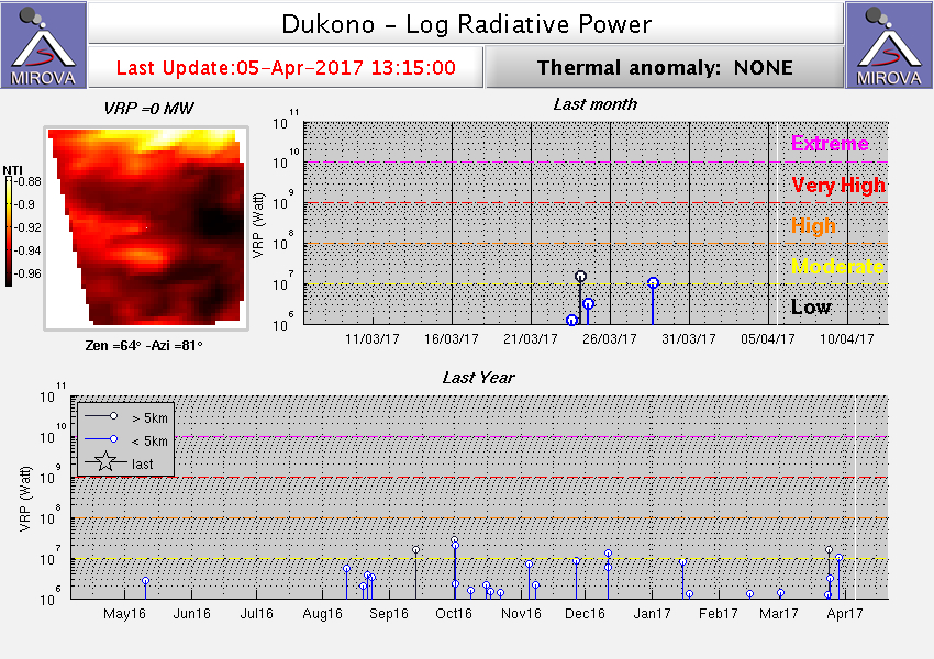 |
Figure 6. Thermal anomalies (Log Radiative Power) detected by MODIS and recorded by the MIROVA system for year ending 5 April 2017. Courtesy of MIROVA. |
Vistors to the crater in March 2016 photographed ash rising form an incandescent vent (figure 7). Patrick Marcel reported that "the vents at the bottom of the crater emitted a sustained, extremely noisy jet of gas, steam and ash, and ejected incandescent bombs to up to 500 m height. Some of them landed outside the crater rim." The "You&MeTraveling2" blog posted a trip journal that described a late-August 2016 visit to Dukono, including photos and a video looking down into the crater that showed activity similar to that seen by Marcel in March 2016.
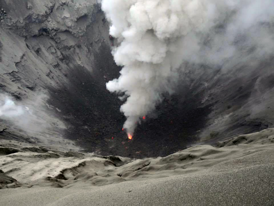 |
Figure 7. View into Dukono's crater on 12 March 2016. Photo by Patrick Marcel (color adjusted from original); courtesy of Volcano Discovery. |
Information Contacts: Pusat Vulkanologi dan Mitigasi Bencana Geologi (PVMBG, also known as Indonesian Center for Volcanology and Geological Hazard Mitigation, CVGHM), Jalan Diponegoro 57, Bandung 40122, Indonesia (URL: http://www.vsi.esdm.go.id/); Darwin Volcanic Ash Advisory Centre (VAAC), Bureau of Meteorology, Northern Territory Regional Office, PO Box 40050, Casuarina, NT 0811, Australia (URL: http://www.bom.gov.au/info/vaac/); Hawai'i Institute of Geophysics and Planetology (HIGP) - MODVOLC Thermal Alerts System, School of Ocean and Earth Science and Technology (SOEST), Univ. of Hawai'i, 2525 Correa Road, Honolulu, HI 96822, USA (URL: http://modis.higp.hawaii.edu/); MIROVA (Middle InfraRed Observation of Volcanic Activity), a collaborative project between the Universities of Turin and Florence (Italy) supported by the Centre for Volcanic Risk of the Italian Civil Protection Department (URL: http://www.mirovaweb.it/); Volcano Discovery (URL: http://www.volcanodiscovery.com/); You&MeTraveling2 (URL: http://youandmetraveling2.com/).
Ongoing ash explosions, thermal anomalies, and sulfur dioxide emissions through March 2018
The current eruption at Dukono has been ongoing since 1933, with frequent explosions and ash plumes between August 2014 and March 2017 (BGVN 42:06). Similar activity has continued during April 2017-March 2018. Monitoring of the volcano is the responsibility of the Pusat Vulkanologi dan Mitigasi Bencana Geologi (PVMBG), also known as the Center for Volcanology and Geological Hazard Mitigation (CVGHM).
Thermal measurements made by MODIS satellite instruments and processed by MIROVA show regular low-to-moderate thermal anomalies from April to October 2017 (figure 8), but none after December 2017 or in early 2018. MODVOLC analyses of thermal satellite data identified anomalies on 11 April, 29 April, 9 July, 1 August, and 21 August 2017.
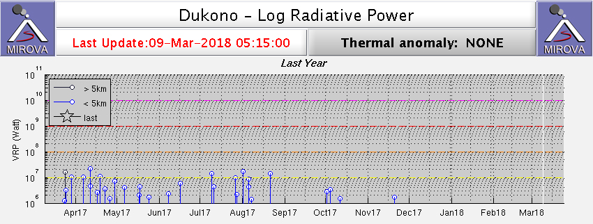 |
Figure 8. Thermal anomalies recorded by the MIROVA system for the year ending 9 March 2018. Courtesy of MIROVA. |
Explosions were frequently reported by both PVMBG and the Darwin Volcanic Ash Advisory Centre (VAAC), with ash plumes rising only a few hundred meters above the Malupang Warirang crater and drifting in various directions (table 17). Some plumes during this reporting period drifted for more than 100 km, with the longest reaching 230 km W on 27 May 2017.
Table 17. Monthly summary of reported ash plumes from Dukono for March 2017-March 2018. The direction of drift for the ash plume through each month is highly variable; only notable significant plumes are listed. Data courtesy of Darwin VAAC and PVMBG.
| Month | Plume Altitude (km) | Notable Plume Drift |
| Apr 2017 | 1.8-2.4 | -- |
| May 2017 | 1.8-2.4 | 230 km W (27 May) |
| Jun 2017 | 1.5-3.0 | 140 km E (07 Jun) |
| Jul 2017 | 1.5-2.7 | -- |
| Aug 2017 | 1.8-2.1 | 150 km (17 Aug) |
| Sep 2017 | 1.5-2.4 | -- |
| Oct 2017 | 1.5-2.1 | 140-170 km (08 Oct) |
| Nov 2017 | 1.8-2.3 | 170 km (04-05 Nov) |
| Dec 2017 | 1.8-2.1 | -- |
| Jan 2018 | 2.1 | -- |
| Feb 2018 | 1.5-2.1 | -- |
| Mar 2018 | 1.5-3.0 | -- |
According to NASA Goddard Space Flight Center, SO2 emissions are commonly detected from Dukono, but usually only at low levels, using the Ozone Monitoring Instrument (OMI) aboard NASA's Earth Observing System (EOS) Aura satellite and the Ozone Mapping and Profiler Suite (OMPS) aboard the NASA/NOAA Suomi National Polar-orbiting Partnership (SNPP) satellite. The strongest emissions captured in satellite data during this report period was on 6 March 2018 (figure 9).
 |
Figure 9. Sulfur dioxide emissions from Dukono can be identified using the Ozone Monitoring Instrument (OMI) on NASA's Aura satellite, as seen in this example from 6 March 2018. The highest amount of SO2 (red) is centered over the volcano. Courtesy of NASA Goddard Space Flight Center. |
Information Contacts: Pusat Vulkanologi dan Mitigasi Bencana Geologi (PVMBG, also known as Indonesian Center for Volcanology and Geological Hazard Mitigation, CVGHM), Jalan Diponegoro 57, Bandung 40122, Indonesia (URL: http://www.vsi.esdm.go.id/); Darwin Volcanic Ash Advisory Centre (VAAC), Bureau of Meteorology, Northern Territory Regional Office, PO Box 40050, Casuarina, NT 0811, Australia (URL: http://www.bom.gov.au/info/vaac/); Hawai'i Institute of Geophysics and Planetology (HIGP) - MODVOLC Thermal Alerts System, School of Ocean and Earth Science and Technology (SOEST), Univ. of Hawai'i, 2525 Correa Road, Honolulu, HI 96822, USA (URL: http://modis.higp.hawaii.edu/); MIROVA (Middle InfraRed Observation of Volcanic Activity), a collaborative project between the Universities of Turin and Florence (Italy) supported by the Centre for Volcanic Risk of the Italian Civil Protection Department (URL: http://www.mirovaweb.it/); NASA Goddard Space Flight Center (NASA/GSFC), Global Sulfur Dioxide Monitoring Page, Atmospheric Chemistry and Dynamics Laboratory, 8800 Greenbelt Road, Goddard, Maryland, USA (URL: https://so2.gsfc.nasa.gov/).
Regular ash explosions continuing as of September 2018
The long-term eruption at Dukono has been characterized by frequent ash explosions through at least March 2018 (BGVN 43:04). The current report shows that this pattern continued through at least September 2018. The data below were provided by the Pusat Vulkanologi dan Mitigasi Bencana Geologi (PVMBG), also known as the Center for Volcanology and Geological Hazard Mitigation (CVGHM), and the Darwin Volcanic Ash Advisory Centre (VAAC).
Between April and September 2018 there were about five reports per month about ash plumes. Altitudes generally ranged from 1.4-2.1 km, although 3 km was reported during 2-8 May and 3.4 km was reported during 25-31 July (table 18).
Table 18. Monthly summary of reported ash plumes from Dukono for April-September 2018. The direction of drift for the ash plume through each month was highly variable. Data courtesy of the Darwin VAAC and PVMBG.
| Month | Plume Altitude (km) | Notable Plume Drift |
| Apr 2018 | 1.5-2.1 | -- |
| May 2018 | 1.5-3 | Ash plumes drifted as far as 225 km NW on 28 May |
| Jun 2018 | 1.4-2.1 | -- |
| Jul 2018 | 1.8-3.4 | -- |
| Aug 2018 | 1.8-2.4 | -- |
| Sep 2018 | 1.8-2.1 | -- |
No thermal anomalies at Dukono, based on MODIS satellite instruments analyzed using the MODVOLC algorithm, were detected during the reporting period. The MIROVA (Middle InfraRed Observation of Volcanic Activity) volcano hotspot detection system, also based on analysis of MODIS data, detected a low-power hotspot in early April (about 2.5 km from the volcano) and a possible low-power hotspot in late August 2018 (about 5 km from the volcano).
Information Contacts: Pusat Vulkanologi dan Mitigasi Bencana Geologi (PVMBG, also known as Indonesian Center for Volcanology and Geological Hazard Mitigation, CVGHM), Jalan Diponegoro 57, Bandung 40122, Indonesia (URL: http://www.vsi.esdm.go.id/); Darwin Volcanic Ash Advisory Centre (VAAC), Bureau of Meteorology, Northern Territory Regional Office, PO Box 40050, Casuarina, NT 0811, Australia (URL: http://www.bom.gov.au/info/vaac/); Hawai'i Institute of Geophysics and Planetology (HIGP) - MODVOLC Thermal Alerts System, School of Ocean and Earth Science and Technology (SOEST), Univ. of Hawai'i, 2525 Correa Road, Honolulu, HI 96822, USA (URL: http://modis.higp.hawaii.edu/); MIROVA (Middle InfraRed Observation of Volcanic Activity), a collaborative project between the Universities of Turin and Florence (Italy) supported by the Centre for Volcanic Risk of the Italian Civil Protection Department (URL: http://www.mirovaweb.it/).
Numerous ash explosions from October 2018 through March 2019
The eruption at Dukono that began in 1933 has showered the area with ash from frequent explosions (BGVN 43:04, 43:12). The Pusat Vulkanologi dan Mitigasi Bencana Geologi (PVMBG), also known as the Center for Volcanology and Geological Hazard Mitigation (CVGHM), is responsible for monitoring this volcano.
This long-term pattern of intermittent ash explosions continued during October 2018-March 2019, with ash plumes rising to between 1.5 and 2.7 km altitude, or about 300-1,500 m above the summit (table 19). Although meteorological clouds often obscured views, satellite imagery captured typical ash plumes on 28 September 2018 (figure 10) and 5 February 2019 (figure 11). Instruments aboard NASA satellites (TROPOMI and OMPS) detected high levels of sulfur dioxide near or directly above the volcano on multiple days during January-March 2019. The Alert Level remained at 2 (on a scale of 1-4), and visitors were warned to remain outside of the 2-km exclusion zone.
Table 19. Monthly summary of reported ash plumes from Dukono for October 2018-March 2019. The direction of drift for the ash plume through each month was highly variable. Data courtesy of the Darwin VAAC and PVMBG.
| Month | Plume Altitude (km) | Notable Plume Drift |
| Oct 2018 | 1.5-2.1 | -- |
| Nov 2018 | 1.5-2.1 | -- |
| Dec 2018 | 1.5-2.4 | -- |
| Jan 2019 | 1.8-2.1 | -- |
| Feb 2019 | 1.8-2.7 | -- |
| Mar 2019 | 1.5-2.4 | -- |
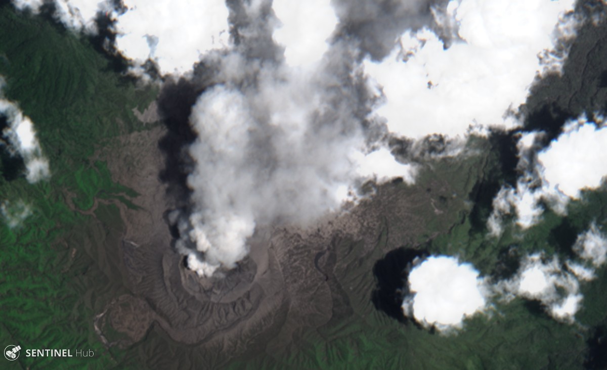 |
Figure 10. Satellite image from Sentinel-2 (LC1 natural color) of an ash plume at Dukono on 28 September 2018 with the plume blowing towards the NE. Courtesy of Sentinel Hub Playground. |
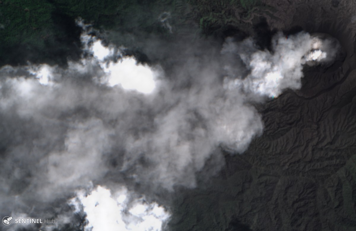 |
Figure 11. Satellite image from Sentinel-2 (LC1 natural color) of an ash plume at Dukono on 5 February 2019, with the plume blowing SW. Courtesy of Sentinel Hub Playground. |
Information Contacts: Pusat Vulkanologi dan Mitigasi Bencana Geologi (PVMBG, also known as Indonesian Center for Volcanology and Geological Hazard Mitigation, CVGHM), Jalan Diponegoro 57, Bandung 40122, Indonesia (URL: http://www.vsi.esdm.go.id/); Darwin Volcanic Ash Advisory Centre (VAAC), Bureau of Meteorology, Northern Territory Regional Office, PO Box 40050, Casuarina, NT 0811, Australia (URL: http://www.bom.gov.au/info/vaac/); Global Sulfur Dioxide Monitoring Page, Atmospheric Chemistry and Dynamics Laboratory, NASA Goddard Space Flight Center (NASA/GSFC), 8800 Greenbelt Road, Goddard, Maryland, USA (URL: https://so2.gsfc.nasa.gov/); Sentinel Hub Playground (URL: https://www.sentinel-hub.com/explore/sentinel-playground).
Eruption with frequent ash plumes continues through September 2019
The eruption at Dukono, ongoing since 1933, is typified by frequent ash explosions and ash plumes (BGVN 43:04). This activity continued through at least September 2019. The data below were primarily provided by the Pusat Vulkanologi dan Mitigasi Bencana Geologi (PVMBG), also known as the Center for Volcanology and Geological Hazard Mitigation (CVGHM), and the Darwin Volcanic Ash Advisory Centre (VAAC).
According to PVMBG, during April-September 2019 the volcano continued to generate ash plumes almost every day that rose to altitudes of 1.5-3 km (table 20, figure 12). Ashfall was reported on 8 August at the Galela Airport, Maluku Utara, 17 km NW. The Alert Level remained at 2 (on a scale of 1-4), and the 2-km exclusion zone remained in effect.
Table 20. Monthly summary of reported ash plumes from Dukono for April-September 2019. The direction of drift for the ash plume through each month was highly variable, but did not extend for any notable distances during this reporting period. Data courtesy of the Darwin VAAC and PVMBG.
| Month | Plume Altitude (km) | Notable Plume Drift |
| Apr 2019 | 1.5-2.4 | -- |
| May 2019 | 1.5-3 | -- |
| Jun 2019 | 1.8-2.4 | -- |
| Jul 2019 | 1.5-2.1 | -- |
| Aug 2019 | 1.8-2.1 | -- |
| Sep 2019 | 1.5-2.1 | -- |
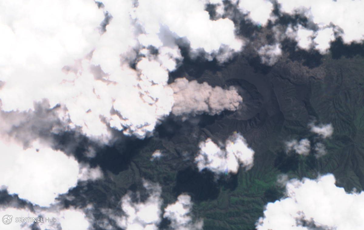 |
Figure 12. Satellite image from Sentinel-2 (natural color) of an ash plume at Dukono on 4 August 2019, with the plume blowing almost straight up. Courtesy of Sentinel Hub Playground. |
Instruments aboard NASA satellites detected high levels of sulfur dioxide near or directly above the volcano on 11, 20-22 April; 17, 22, and 27 May; 15-18 August; and 23-24 and 29 September. However, the cause of the high levels may, at least in part, have been due to other active volcanoes in the area.
Information Contacts: Pusat Vulkanologi dan Mitigasi Bencana Geologi (PVMBG, also known as Indonesian Center for Volcanology and Geological Hazard Mitigation, CVGHM), Jalan Diponegoro 57, Bandung 40122, Indonesia (URL: http://www.vsi.esdm.go.id/); Darwin Volcanic Ash Advisory Centre (VAAC), Bureau of Meteorology, Northern Territory Regional Office, PO Box 40050, Casuarina, NT 0811, Australia (URL: http://www.bom.gov.au/info/vaac/); Global Sulfur Dioxide Monitoring Page, Atmospheric Chemistry and Dynamics Laboratory, NASA Goddard Space Flight Center (NASA/GSFC), 8800 Greenbelt Road, Goddard, Maryland, USA (URL: https://so2.gsfc.nasa.gov/); Sentinel Hub Playground (URL: https://www.sentinel-hub.com/explore/sentinel-playground).
Numerous ash explosions continue through March 2020
The ongoing eruption at Dukono is characterized by frequent explosions that send ash plumes to about 1.5-3 km altitude (0.3-1.8 km above the summit), although a few have risen higher. This type of typical activity (figure 13) continued through at least March 2020. The ash plume data below (table 21) were primarily provided by the Pusat Vulkanologi dan Mitigasi Bencana Geologi (PVMBG) and the Darwin Volcanic Ash Advisory Centre (VAAC). During the reporting period of October 2019-March 2020, the Alert Level remained at 2 (on a scale of 1-4) and the public was warned to remain outside of the 2-km exclusion zone.
Table 21. Monthly summary of reported ash plumes from Dukono for October 2019-March 2020. The direction of drift for the ash plume through each month was highly variable; notable plume drift each month was only indicated in the table if at least two weekly reports were consistent. Data courtesy of the Darwin VAAC and PVMBG.
| Month | Plume Altitude (km) | Notable Plume Drift |
| Oct 2019 | 1.8-3 | Multiple |
| Nov 2019 | 1.8-2.3 | E, SE, NE |
| Dec 2019 | 1.8-2.1 | E, SE |
| Jan 2020 | 1.8-2.1 | E, SE, SW, S |
| Feb 2020 | 2.1-2.4 | S, SW |
| Mar 2020 | 1.5-2.3 | Multiple |
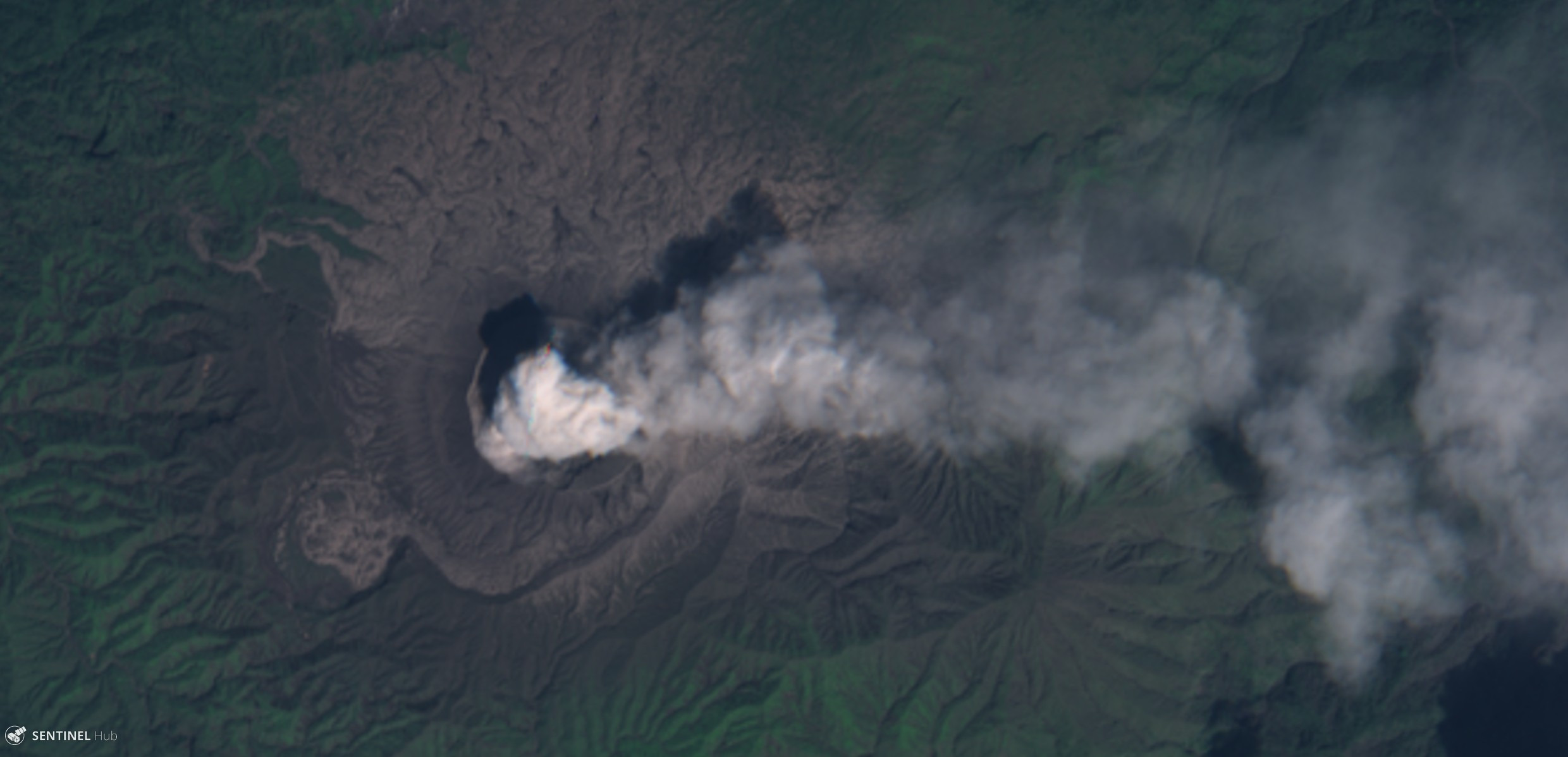 |
Figure 13.Satellite image of Dukono from Sentinel-2 on 12 November 2019, showing an ash plume drifting E. Image uses natural color rendering (bands 4, 3, 2). Courtesy of Sentinel Hub Playground. |
During the reporting period, high levels of sulfur dioxide were only recorded above or near the volcano during 30-31 October and 4 November 2019. High levels were recorded by the Ozone Mapping and Profiler Suite (OMPS) instrument aboard the Suomi National Polar-orbiting Partnership (NPP) satellite on 30 October 2019, in a plume drifting E. The next day high levels were also recorded by the TROPOspheric Monitoring Instrument (TROPOMI) aboard the Copernicus Sentinel-5 Precursor satellite on 31 October (figure 14) and 4 November 2019, in plumes drifting SE and NE, respectively.
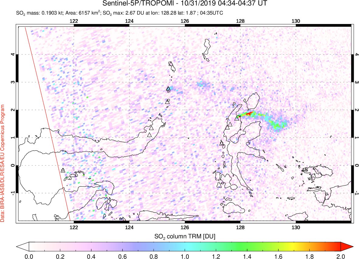 |
Figure 14. Sulfur dioxide emission on 31 October 2019 drifting E, probably from Dukono, as recorded by the TROPOMI instrument aboard the Sentinel-5P satellite. Courtesy of NASA Global Sulfur Dioxide Monitoring Page. |
Information Contacts: Pusat Vulkanologi dan Mitigasi Bencana Geologi (PVMBG, also known as Indonesian Center for Volcanology and Geological Hazard Mitigation, CVGHM), Jalan Diponegoro 57, Bandung 40122, Indonesia (URL: http://www.vsi.esdm.go.id/); Darwin Volcanic Ash Advisory Centre (VAAC), Bureau of Meteorology, Northern Territory Regional Office, PO Box 40050, Casuarina, NT 0811, Australia (URL: http://www.bom.gov.au/info/vaac/); Global Sulfur Dioxide Monitoring Page, Atmospheric Chemistry and Dynamics Laboratory, NASA Goddard Space Flight Center (NASA/GSFC), 8800 Greenbelt Road, Goddard, Maryland, USA (URL: https://so2.gsfc.nasa.gov/); Sentinel Hub Playground (URL: https://www.sentinel-hub.com/explore/sentinel-playground).
Frequent gas-and-steam emissions, SO2 plumes, and ash plumes during April-September 2020
Dukono is one of Indonesia’s most active volcanoes and has been erupting continuously since 1933. Volcanism is primarily characterized by ash explosions and frequent ash plumes (BGVN 45:05). This report updates volcanic activity dominantly consisting of white and gray gas-and-steam emissions and ash plumes from April to September 2020, using primary information from the Pusat Vulkanologi dan Mitigasi Bencana Geologi (PVMBG, also known as Indonesian Center for Volcanology and Geological Hazard Mitigation, CVGHM), the Darwin Volcanic Ash Advisory Centre (VAAC), and satellite data.
Volcanism at Dukono during this period dominantly consisted of white and gray gas-and-steam emissions, accompanied by intermittent ash plumes that drifted in multiple directions. The ash plumes rose to 1.5-4.3 km altitude, or about 300-3,100 m above the summit, according to PVMBG and the Darwin VAAC advisories (table 22).
Table 22. Monthly summary of reported ash plumes from Dukono during April-September 2020. The direction of drift for the ash plumes was highly variable; notable plume drifts each month were only indicated in the table if at least two weekly reports were consistent. Data courtesy of PVMBG and the Darwin VAAC.
| Month | Plume altitude (km) | Notable Plume Drift |
| Apr 2020 | 1.8-2.4 | Multiple |
| May 2020 | 1.5-2.1 | E, NE |
| Jun 2020 | 1.8-2.4 | NW, SW, S, NNE, W |
| Jul 2020 | 1.8-2.4 | NW, W |
| Aug 2020 | 1.8-4.3 | Multiple |
| Sep 2020 | 1.8-2.7 | Multiple |
Activity during April was primarily characterized by white and gray gas-and-steam emissions, accompanied by intermittent ash plumes that rose 1.8-2.4 km altitude drifting in multiple directions (figure 15). Similar frequent gas-and-steam emissions continued into May, with ash plumes rising from 1.5 to 2.1 km altitude and drifting generally E, and NE, according to PVMBG VONA notices and the Darwin VAAC advisories. On 30 May six eruptions were observed, producing white and gray emissions 100-300 m above the crater.
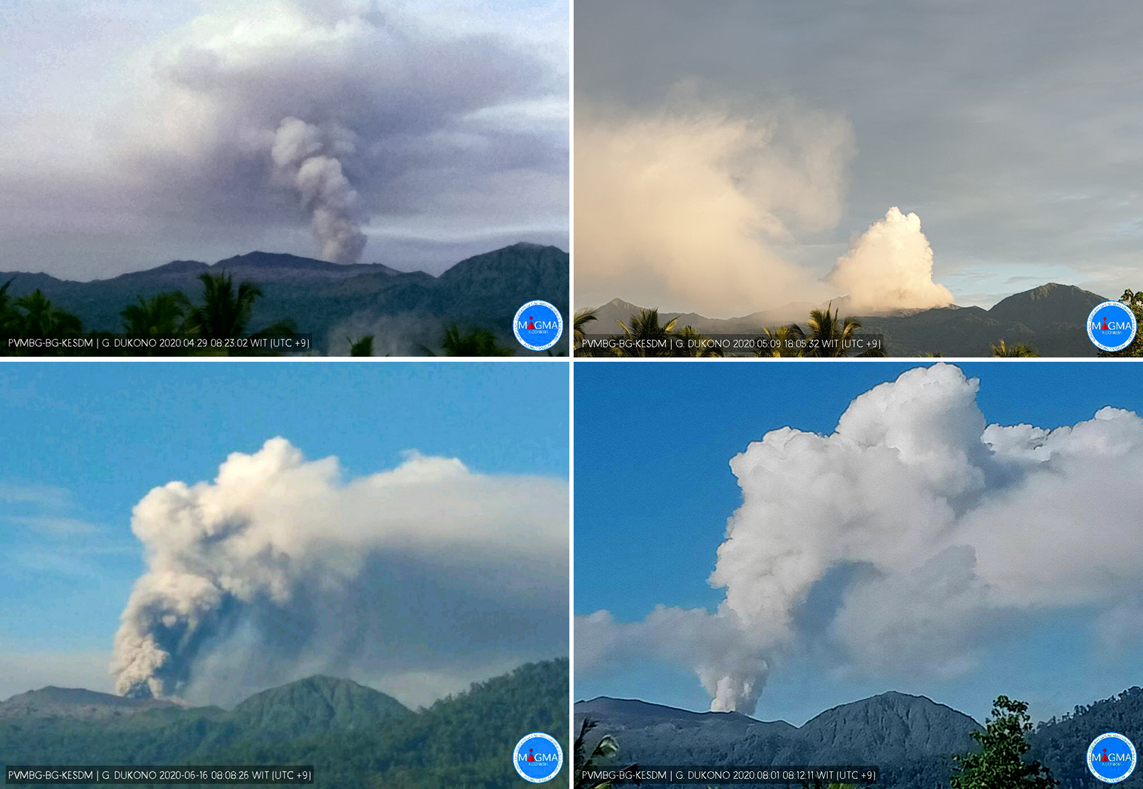 |
Figure 15. Webcam images of the frequent white and gray gas-and-steam plumes rising from Dukono on 29 April (top left), 9 May (top right), 16 June (bottom left), and 1 August (bottom right) 2020. Courtesy of MAGMA Indonesia. |
During June, the white and gray gas-and-steam emissions continued with the accompanying ash plumes rising to 1.8-2.4 km altitude and typically drifting NW, SW, S, NNE, and W. On 24 June a strong ash plume was observed in Sentinel-2 satellite imagery rising 2.1 km altitude and drifting NW and W, according to a Darwin VAAC notice (figure 16). Activity remained consistent in July, with ash plumes reaching 2.4 km altitude and drifting generally NW and W. On 11 July PVMBG reported that an eruption occurred at 0801; a second eruption was detected at 0806 on 12 July, which produced an ash plume roughly 700 m above the crater by 0949. On 31 July an eruption column was observed rising 500 m above the crater.
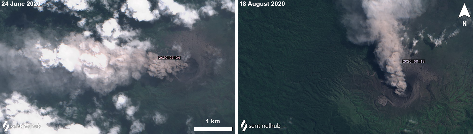 |
Figure 16. Sentinel-2 satellite images of a dense ash plume rising from Dukono and drifting W on 24 June (left) and N on 18 August (right) 2020. Images with “Natural color” rendering (bands 4, 3, 2); courtesy of Sentinel Hub Playground. |
In August, similar activity from the previous months persisted, with ash plumes rising now to 4.3 km altitude and drifting in multiple directions, according to the Darwin VAAC advisories. On 3 August an eruption column rose 500 m above the crater, and on 5 August an eruption was observed up to 400 m above the crater. PVMBG released a VONA report stating that an eruption on 7 August at 0817 produced an ash plume that rose 400 m above the crater drifting E. The Darwin VAAC issued an advisory on 17-18 August stating that a discrete ash plume rose to a maximum altitude of 4.3 km, drifting W and was associated with a summit thermal anomaly (figure 16). On 27 August an eruption plume was seen rising 600 m above the crater.
Activity in September was similar: white and gray gas-and-steam emissions remained consistent above the crater with intermittent ash plumes rising 1.8-2.7 km altitude and drifting in multiple directions. On 14 and 18-19 September an eruption produced ash plumes that rose 500 m above the crater.
The NASA Global Sulfur Dioxide page, using data from the TROPOMI instrument on the Sentinel-5P satellite, showed strong SO2 plumes rising from Dukono and drifting in various directions, though most often to the W (figure 17). These SO2 plumes were frequently detected during the reporting period, alongside occasional weak thermal anomalies in the summit crater, as observed in Sentinel-2 thermal satellite imagery (figure 18).
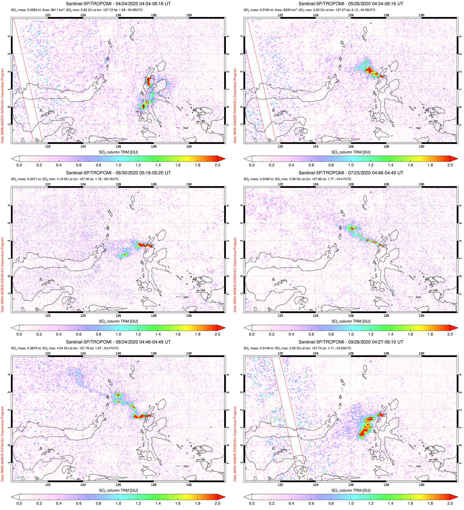 |
Figure 17. Strong sulfur dioxide emissions that rose from Dukono and drifted in multiple directions were detected using the TROPOMI instrument on the Sentinel-5P satellite on 24 April (top left), 26 May (top right), 30 June (middle left), 23 July (middle right), 24 August (bottom left), and 26 September (bottom right) 2020. Courtesy of the NASA Global Sulfur Dioxide Monitoring Page. |
 |
Figure 18. Sentinel-2 thermal satellite imagery of Dukono showing a weak thermal anomaly in the summit crater during April, May, July, and September 2020. Images with “Atmospheric penetration” (bands 12, 11, 8A) rendering; courtesy of Sentinel Hub Playground. |
Information Contacts: Pusat Vulkanologi dan Mitigasi Bencana Geologi (PVMBG, also known as Indonesian Center for Volcanology and Geological Hazard Mitigation, CVGHM), Jalan Diponegoro 57, Bandung 40122, Indonesia (URL: http://www.vsi.esdm.go.id/); MAGMA Indonesia, Kementerian Energi dan Sumber Daya Mineral (URL: https://magma.vsi.esdm.go.id/); Darwin Volcanic Ash Advisory Centre (VAAC), Bureau of Meteorology, Northern Territory Regional Office, PO Box 40050, Casuarina, NT 0811, Australia (URL: http://www.bom.gov.au/info/vaac/); Global Sulfur Dioxide Monitoring Page, Atmospheric Chemistry and Dynamics Laboratory, NASA Goddard Space Flight Center (NASA/GSFC), 8800 Greenbelt Road, Goddard, Maryland, USA (URL: https://so2.gsfc.nasa.gov/); Sentinel Hub Playground (URL: https://www.sentinel-hub.com/explore/sentinel-playground).
Ash and sulfur dioxide plumes during October 2020-March 2021
Dukono, located in northernmost Halmahera, Indonesia, has been erupting continuously since 1933. Volcanism has recently been characterized by frequent ash explosions, ash plumes, and sulfur dioxide plumes (BGVN 45:10). This report updates activity consisting of white-and-gray plumes and sulfur dioxide plumes during October 2020-March 2021 using information primarily from the Pusat Vulkanologi dan Mitigasi Bencana Geologi (PVMBG, also known as Indonesian Center for Volcanology and Geological Hazard Mitigation, CVGHM), the Darwin Volcanic Ash Advisory Centre (VAAC), and satellite data.
Volcanism at Dukono has been characterized by dominantly white-and-gray plumes, accompanied by intermittent ash plumes that drifted in multiple directions. On clear weather days, the ash plumes rose to 1.5-2.4 km altitude, or about 270-1,200 m above the crater, according to PVMBG and the Darwin VAAC advisories (table 23).
Table 23. Monthly summary of reported ash plumes from Dukono during October 2020-March 2021. The direction of drift for the ash plumes was highly variable; notable plume drifts each month were only indicated in the table if at least two weekly reports were consistent. Data courtesy of PVMBG and the Darwin VAAC.
| Month | Plume altitude (km) | Notable plume drift |
| Oct 2020 | 1.8-2.4 | W, N, NE, E, SW |
| Nov 2020 | 1.5-2.1 | Multiple directions |
| Dec 2020 | 1.5-2.4 | SE, E |
| Jan 2021 | 1.5-2.1 | SW, E |
| Feb 2021 | 1.5-2.1 | Multiple directions |
| Mar 2021 | 1.5-2.4 | Multiple directions |
Activity during October 2020 primarily consisted of near daily white-and-gray plumes that rose 100-700 m above the crater and drifted in multiple directions (figure 19). Ash plumes during this month rose between 1.8 and 2.4 km altitude and drifted W, N, NE, E, SW, according to PVMBG VONA notices and the Darwin VAAC advisories. Frequent white gas-and-steam emissions were also observed in webcam images. Similar activity continued in November, with almost daily white-and-gray plumes rising 100-800 m above the crater and drifting in multiple directions. On clear weather days ash plumes were observed up to 2.1 km altitude; on 12 November the ash plume rose up to 2.1 km altitude and drifted SW (figure 19).
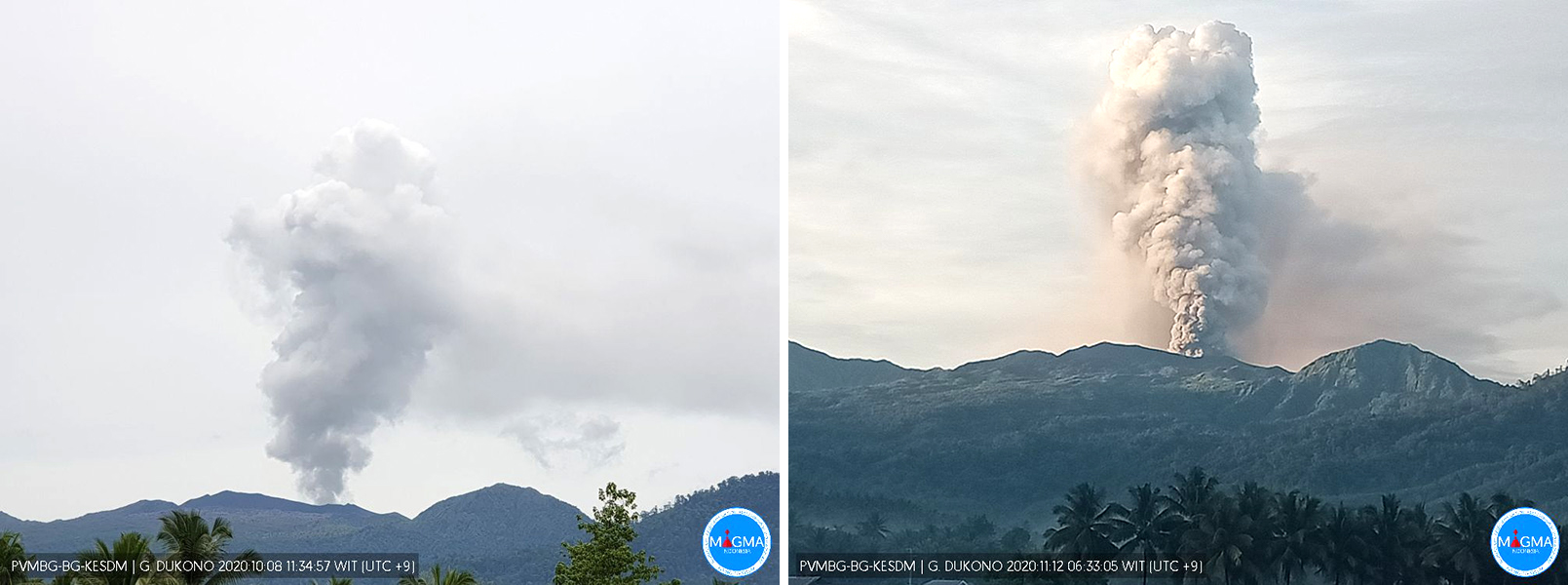 |
Figure 19. Webcam images of white-and-gray plumes rising from Dukono on 8 October (left) and an ash plume on 12 November (right) 2020. Courtesy of MAGMA Indonesia. |
In December and January 2021, white-and-gray plumes were 100-700 m above the crater and drifted in multiple directions, dominantly E and W in December and SW in January. According to Darwin VAAC advisories during these two months, ash plumes were seen rising to 2.4 km altitude and drifted notably SE, E, and SW.
Activity in February persisted with white-and gray plumes rising 100-600 m above the crater and drifting dominantly SW and E (figure 20). Intermittent ash plumes rose to 2.1 km altitude during February and 2.4 km altitude during March, drifting in multiple directions. Gas-and-steam plumes were also frequent. During March, almost daily white-and-gray plumes rose 100-800 m above the crater and drifted in multiple directions (figure 20).
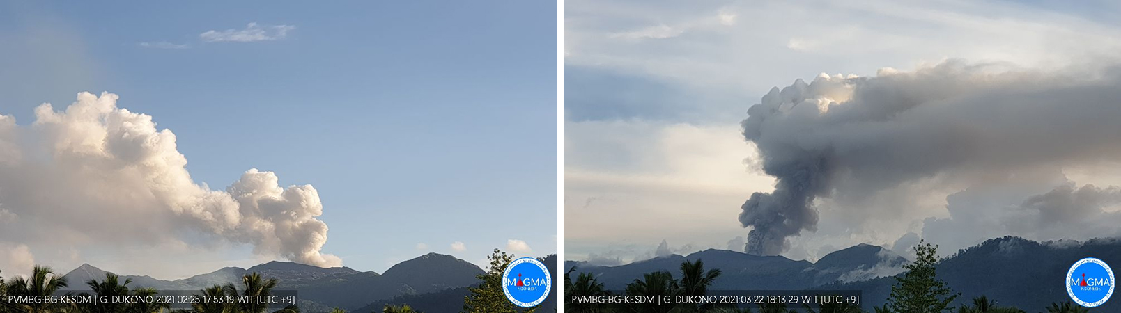 |
Figure 20. Webcam images of white-and-gray plumes rising from Dukono on 25 February (left) and 22 March (right) 2021. Courtesy of MAGMA Indonesia. |
The NASA Global Sulfur Dioxide page, using data from the TROPOMI instrument on the Sentinel-5P satellite, showed strong SO2 plumes rising from Dukono and drifting in various directions (figure 21). In addition to SO2 plumes, Sentinel-2 thermal satellite imagery showed thermal anomalies of variable intensities on clear weather days (figure 22). Intermittent thermal anomalies recorded by the MIROVA (Middle InfraRed Observation of Volcanic Activity) system during early December 2020 through mid-March 2021 were low in power (figure 23). A brief break in thermal activity occurred during mid- to late-February.
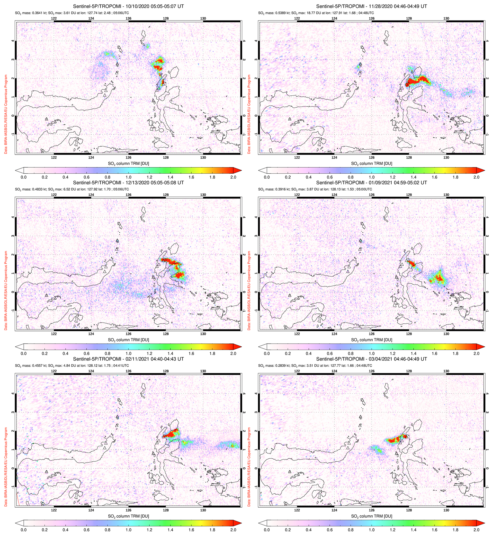 |
Figure 21. Strong sulfur dioxide emissions rose from Dukono and drifted in multiple directions were detected using the TROPOMI instrument on the Sentinel-5P satellite. SO2 plumes drifted N on 10 October (top left), generally E on 28 November (top right), 13 December (middle left) 2020, and 11 February 2021 (bottom left), SE on 9 January (middle right) 2021, and W on 4 March (bottom right) 2021. Courtesy of the NASA Global Sulfur Dioxide Monitoring Page. |
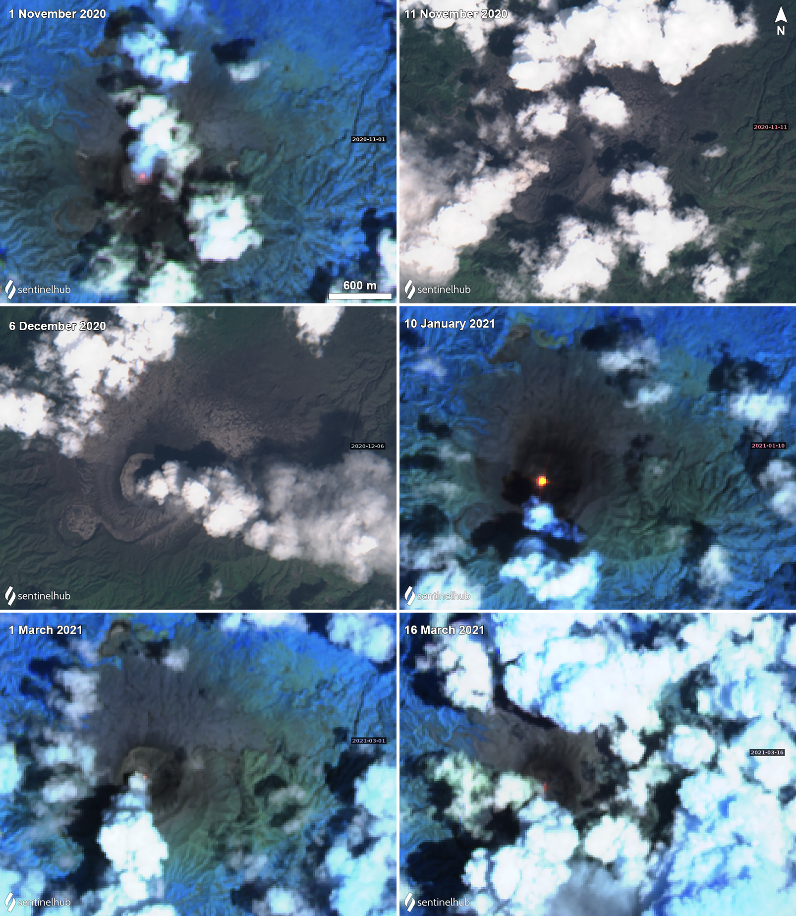 |
Figure 22. Sentinel-2 thermal satellite imagery showing a thermal anomaly in the summit crater on 1 November (top left) 2020, 10 January (middle right), 1 March (bottom left), and 16 March (bottom right) 2021, frequently accompanied by gas-and-steam and ash plumes. On 11 November (top right) and 6 December (middle left) 2020 a Natural Color image showed a grayish white ash plume drifting SW and SE, respectively. Sentinel-2 satellite images with “Natural Color” rendering (bands 4, 3, 2) on 11 November and 6 December 2020, all other images use “Atmospheric penetration” (bands 12, 11, 8A) rendering. Courtesy of Sentinel Hub Playground. |
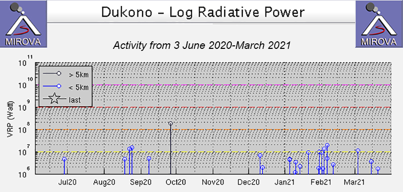 |
Figure 23. MIROVA (Log Radiative Power) thermal data for Dukono from 3 June 2020 through March 2021 showed intermittent low power thermal activity during early December 2020 through mid-March 2020. A brief break in activity occurred during mid- to late-February. Courtesy of MIROVA. |
Information Contacts: Pusat Vulkanologi dan Mitigasi Bencana Geologi (PVMBG, also known as Indonesian Center for Volcanology and Geological Hazard Mitigation, CVGHM), Jalan Diponegoro 57, Bandung 40122, Indonesia (URL: http://www.vsi.esdm.go.id/); MAGMA Indonesia, Kementerian Energi dan Sumber Daya Mineral (URL: https://magma.esdm.go.id/v1); Darwin Volcanic Ash Advisory Centre (VAAC), Bureau of Meteorology, Northern Territory Regional Office, PO Box 40050, Casuarina, NT 0811, Australia (URL: http://www.bom.gov.au/info/vaac/); NASA Global Sulfur Dioxide Monitoring Page, Atmospheric Chemistry and Dynamics Laboratory, NASA Goddard Space Flight Center (NASA/GSFC), 8800 Greenbelt Road, Goddard, Maryland, USA (URL: https://so2.gsfc.nasa.gov/); Sentinel Hub Playground (URL: https://www.sentinel-hub.com/explore/sentinel-playground).
Ash and sulfur dioxide plumes continue during April-September 2021
The ongoing volcanic activity at Dukono has consisted of frequent ash explosions and sulfur dioxide emissions (BGVN 46:04). This activity continued during March-September 2021. The data below were primarily provided by the Pusat Vulkanologi dan Mitigasi Bencana Geologi (PVMBG), also known as the Center for Volcanology and Geological Hazard Mitigation (CVGHM), the Darwin Volcanic Ash Advisory Centre (VAAC), and satellite sensors. Since 15 June 2008 the Alert Level has remained at 2 (on a scale of 1-4) and the public has been warned to remain outside of the 2-km exclusion zone.
Numerous weak ash explosions continued during April-September 2021, generating plumes that rose to altitudes of 1.3-2.4 km and drifted in multiple directions (figure 24). Plume elevations reported by PVMBG ranged from 100 to 800 m above the summit (1.3-2.0 km altitude), somewhat lower than those reported by the Darwin VAAC (1.8-2.4 km altitude). One news report (Halmahera Post.com) in mid-April stated that heavy ash fell on the town of Tobelo (13 km ENE); an official with PVMBG was quoted in that report as suggesting that some of the ashfall was due to explosions caused by frequent rainfall at the summit. Although meteorological clouds usually obscured views, Sentinel-2 satellite images on 5 April and 19 July clearly showed the ash plumes (figure 25).
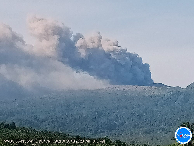 |
Figure 24. Ash plumes from rising Dukono are visible in this webcam photo on 20 April 2021. Courtesy of MAGMA Indonesia. |
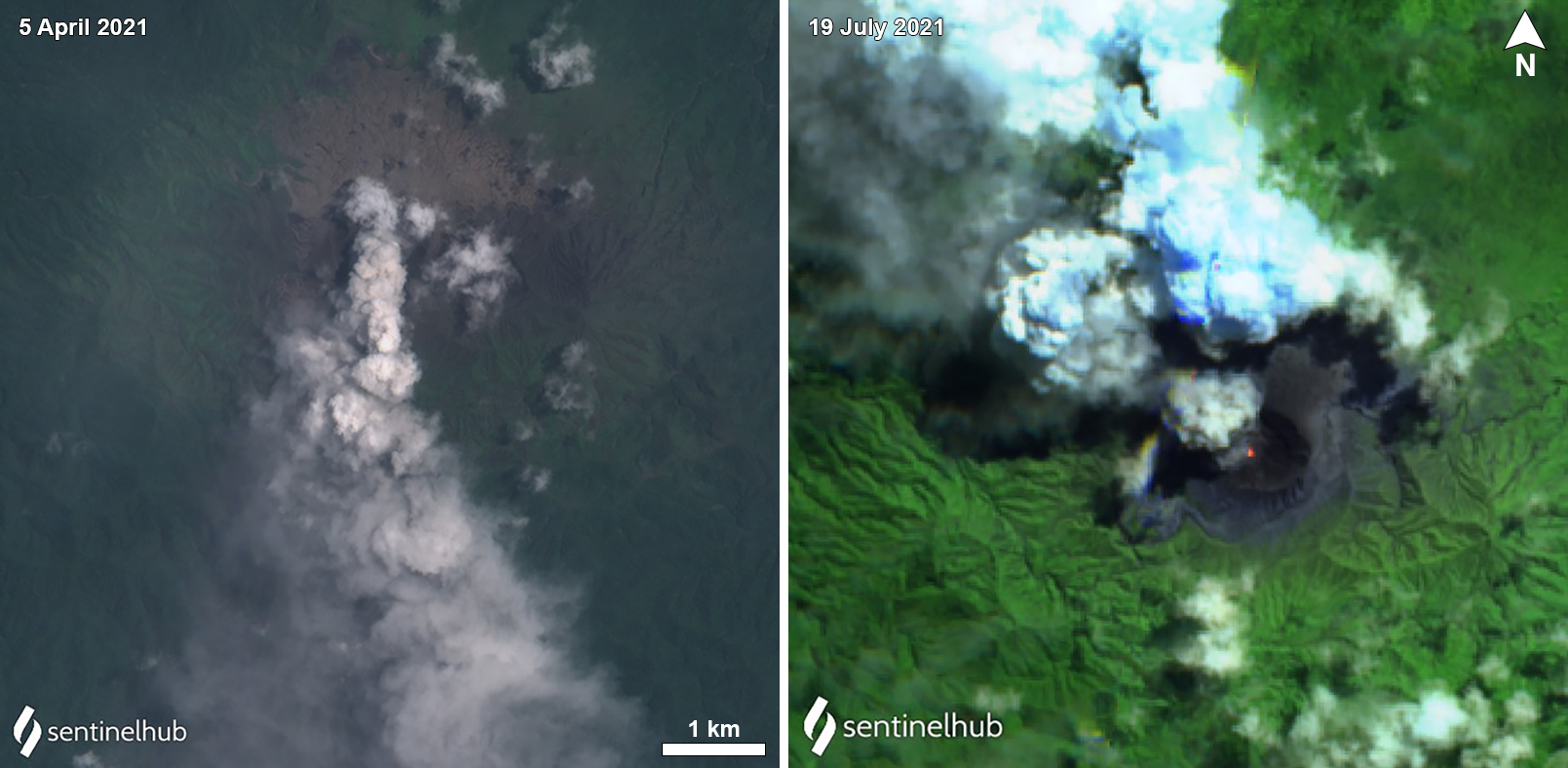 |
Figure 25. Sentinel-2 images showing ash plumes from Dukono on 5 April (left) and 19 July 2021 (right). The 5 April natural-color image (bands 4, 3, 2) shows the plume drifting S; the 19 July false-color image (bands 12, 11, 4) shows the plume drifting NW with a weak thermal anomaly in the active crater. Weak thermal anomalies were also observed during late 2020 and early 2021 (BGVN 46:04). Courtesy of Sentinel Hub Playground. |
Strong SO2 plumes were evident during at least half the days during the reporting period. The plumes were especially intense and extensive during May and June (figure 26). MIROVA thermal alerts were intermittent and primarily of low power during April-September 2021, with a slight spike in numbers in early April (figure 27). In its 30 September 2021 Disaster report, PVMBG stated that seismograph recordings had shown continuous tremor, with amplitudes 0.5-2 mm, with 1 mm predominating
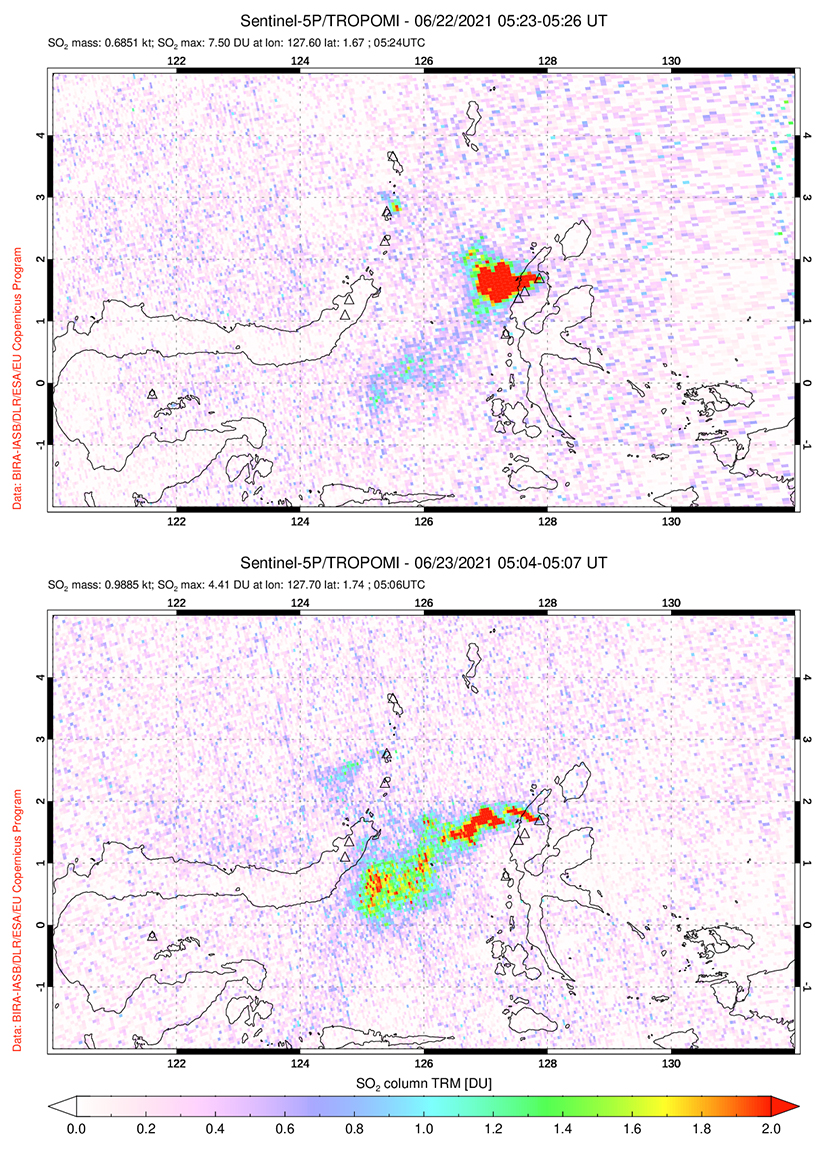 |
Figure 26. Sulfur dioxide emissions from Dukono were detected using the TROPOMI instrument on the Sentinel-5P satellite, seen here drifting W on 22 and 23 June, to a distance of 370 km. Courtesy of the NASA Global Sulfur Dioxide Monitoring Page. |
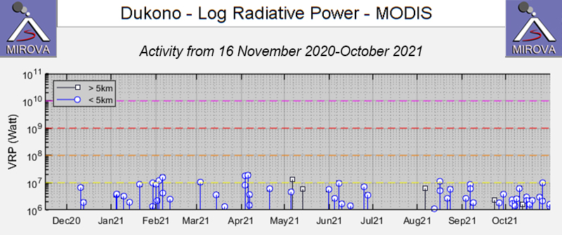 |
Figure 27. The MIROVA (Log Radiative Power) thermal data for Dukono during the year ending on 16 November 2021 showed intermittent low-power thermal activity during April-September 2021. Courtesy of MIROVA. |
Information Contacts: Pusat Vulkanologi dan Mitigasi Bencana Geologi (PVMBG, also known as Indonesian Center for Volcanology and Geological Hazard Mitigation, CVGHM), Jalan Diponegoro 57, Bandung 40122, Indonesia (URL: http://www.vsi.esdm.go.id/); MAGMA Indonesia, Kementerian Energi dan Sumber Daya Mineral (URL: https://magma.esdm.go.id/v1); Darwin Volcanic Ash Advisory Centre (VAAC), Bureau of Meteorology, Northern Territory Regional Office, PO Box 40050, Casuarina, NT 0811, Australia (URL: http://www.bom.gov.au/info/vaac/); NASA Global Sulfur Dioxide Monitoring Page, Atmospheric Chemistry and Dynamics Laboratory, NASA Goddard Space Flight Center (NASA/GSFC), 8800 Greenbelt Road, Goddard, Maryland, USA (URL: https://so2.gsfc.nasa.gov/); Sentinel Hub Playground (URL: https://www.sentinel-hub.com/explore/sentinel-playground); MIROVA (Middle InfraRed Observation of Volcanic Activity), a collaborative project between the Universities of Turin and Florence (Italy) supported by the Centre for Volcanic Risk of the Italian Civil Protection Department (URL: http://www.mirovaweb.it/); Halmahera Post (URL: https://halmaherapost.com/).
Continuing ash emissions, SO2 plumes, and thermal signals through March 2022
The remote Dukono volcano on the island of Halmahera has been erupting continuously since 1933, with ash explosions, frequent ash plumes, and sulfur dioxide (SO2) plumes. This reports updates activity during October 2021-March 2022, and is based on the Pusat Vulkanologi dan Mitigasi Bencana Geologi (PVMBG; also known as Indonesian Center for Volcanology and Geological Hazard Mitigation, CVGHM), the Darwin Volcanic Ash Advisory Centre (VAAC), and satellite data. During this period, volcanism appears to have diminished relative to that indicated in previous reports.
According to PVMBG, during 19 and 22-26 October white-and-gray ash plumes rose as high as 300 m above the summit (1.5 km altitude) and drifted E and W. Based on satellite and wind model data, the Darwin VAAC reported that on 17 November ash plumes rose to an altitude of 2.1 km and drifted NE and ENE. During 18-23 November dense white plumes rose as high as 500 m (1.7 km altitude) and drifted NW, W, and SW, as reported by PVMBG. According to the Darwin VAAC, on 13 February 2022 ash plumes rose to an altitude of 2.1 km and drifted SW; during 26-31 March, ash plumes rose to an altitude of 2.1-2.4 km and drifted SE, E, and ENE.
Satellite views of the volcano often showed thermal anomalies, but good views were obscured by weather clouds throughout most of the reporting period. However, clouds cleared sufficiently on several days to allow clear observations of thermal anomalies at the summit crater and ash plumes, such as on 12 October 2021, 25 January 2022, and 31 March 2022 (figure 28). Thermal measurements made by MODIS satellite instruments and processed by MIROVA showed intermittent low-to-moderate power activity, with a greater concentration of signals during October 2021. The only thermal alerts recorded by MODIS-MODVOLC were on 12 October 2021 and 7 and 30 January 2022. The NASA Global Sulfur Dioxide page, using data from the TROPOMI instrument aboard the Sentinel-5P satellite, showed numerous days with strong SO2 plumes near the volcano (figure 29). The number of days with high SO2 concentrations was greatest in October 2021 (15), decreasing in November (11), December (4), January 2022 (10), February (5), and March (8).
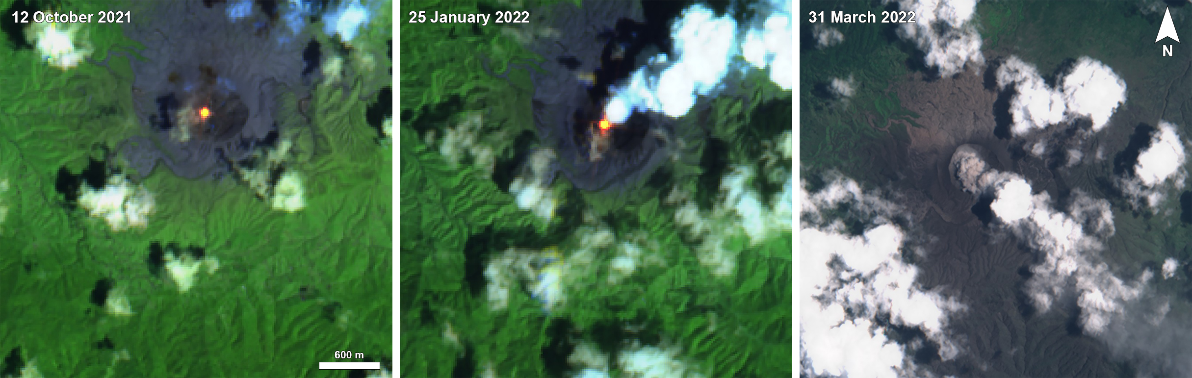 |
Figure 28. Intermittent clear satellite views Dukono during October 2021-March 2022 showed ongoing volcanism. A clear thermal anomaly was detected in the summit crater on 12 October 2021 (left), possibly with a small ash plume drifting SW. On 25 January 2022 (center) a stronger thermal signal could be seen along with a steam plume and possible small ash emission. A distinct ash plume on 31 March 2022 (right) was consistent with Darwin VAAC reports. Thermal anomalies were also present on less favorable viewing days. Sentinel-2 images with false color rendering (bands 12, 11, 4) (left and center), and natural rendering (bands 4, 3, 2) (right). Courtesy of Sentinel Hub Playground. |
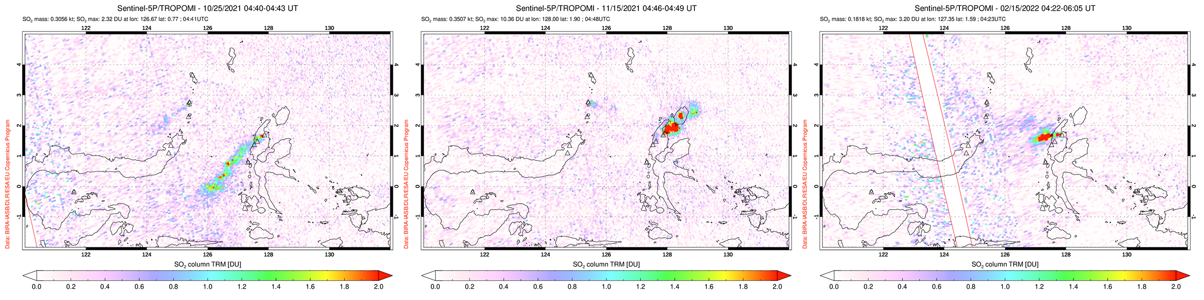 |
Figure 29. Representative maps from the October 2021-March 2022 period showing strong SO2 plumes from Dukono detected using the TROPOMI instrument on the Sentinel-5P satellite. Plumes drifted SW on 25 October 2021 during an explosive period (left), NE on 15 November 2021 (center), and W on 15 February after an explosion two days earlier (right). Courtesy of the NASA Global Sulfur Dioxide Monitoring Page. |
Information Contacts: Pusat Vulkanologi dan Mitigasi Bencana Geologi (PVMBG, also known as Indonesian Center for Volcanology and Geological Hazard Mitigation, CVGHM), Jalan Diponegoro 57, Bandung 40122, Indonesia (URL: http://www.vsi.esdm.go.id/); Darwin Volcanic Ash Advisory Centre (VAAC), Bureau of Meteorology, Northern Territory Regional Office, PO Box 40050, Casuarina, NT 0811, Australia (URL: http://www.bom.gov.au/info/vaac/); NASA Global Sulfur Dioxide Monitoring Page, Atmospheric Chemistry and Dynamics Laboratory, NASA Goddard Space Flight Center (NASA/GSFC), 8800 Greenbelt Road, Goddard, Maryland, USA (URL: https://so2.gsfc.nasa.gov/); Sentinel Hub Playground (URL: https://www.sentinel-hub.com/explore/sentinel-playground); MIROVA (Middle InfraRed Observation of Volcanic Activity), a collaborative project between the Universities of Turin and Florence (Italy) supported by the Centre for Volcanic Risk of the Italian Civil Protection Department (URL: http://www.mirovaweb.it/); Halmahera Post (URL: https://halmaherapost.com/); Hawai'i Institute of Geophysics and Planetology (HIGP) - MODVOLC Thermal Alerts System, School of Ocean and Earth Science and Technology (SOEST), Univ. of Hawai'i, 2525 Correa Road, Honolulu, HI 96822, USA (URL: http://modis.higp.hawaii.edu/).
Frequent weak ash explosions and plumes through September 2022
Dukono has been erupting continuously since 1933, with frequent ash explosions, ash plumes, and sulfur dioxide plumes (BGVN 46:11). After a period of diminished volcanism during October 2021-March 2022 (BGVN 47:04), activity resumed its more usual heightened pattern through September 2022. The data below were primarily provided by the Pusat Vulkanologi dan Mitigasi Bencana Geologi (PVMBG), also known as the Center for Volcanology and Geological Hazard Mitigation (CVGHM), the Darwin Volcanic Ash Advisory Centre (VAAC), and satellite sensors. Since 15 June 2008, the Alert Level has remained at 2 (on a scale of 1-4) and the public has been warned to remain outside of the 2-km exclusion zone (BGVN 46:11).
According to almost daily images from MAGMA Indonesia (a platform developed by PVMBG), white, gray, or dark plumes were observed almost every day during the reporting period (figure 30). According to the Darwin VAAC, plumes reached an altitude of 2.1-2.7 km (900-1,500 m above the summit) during the last week of May. PVMBG reported that during July-September 2022 plumes often rose 200-1,000 m above the summit.
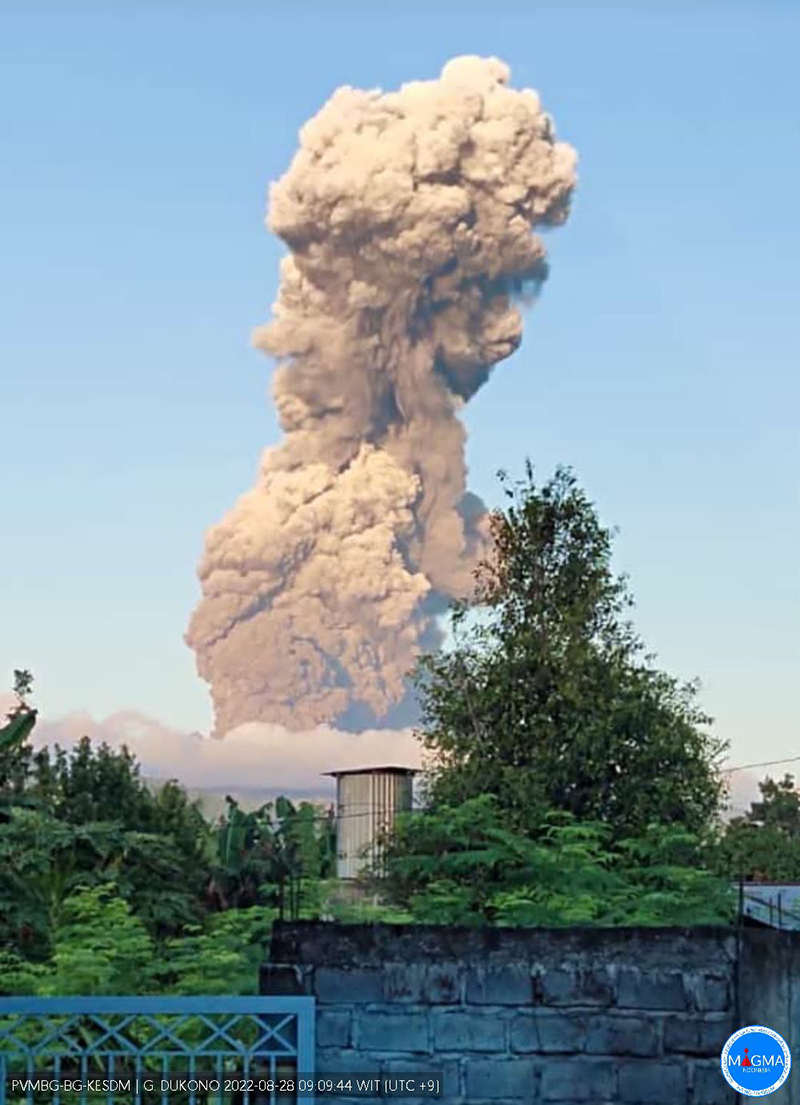 |
Figure 30. Photo of an ash plume rising from Dukono on 28 August 2022. Courtesy of MAGMA Indonesia. |
During the few days when the volcano was not obscured by weather clouds, Sentinel-2 satellite images recorded ash plumes and an occasional thermal anomaly in the summit crater (figure 31). The MIROVA system also recorded a few scattered, low-strength hotspots. Strong sulfur dioxide plumes above the volcano were detected on numerous days every month of the reporting period (figure 32), but their intensity appeared to diminish during August and September 2022.
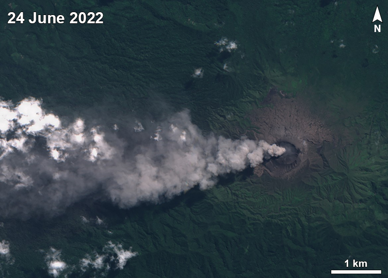 |
Figure 31. Sentinel-2 satellite image of ash plume blowing W from Dukono on 24 June 2022. Sentinel-2 images with natural rendering (bands 4, 3, 2). Courtesy of Sentinel Hub Playground. |
 |
Figure 32. Example of a sulfur dioxide plume from Dukono on 5 May 2022, as detected by the TROPOMI instrument aboard the Sentinel-5P satellite. Courtesy of the NASA Global Sulfur Dioxide Monitoring Page. |
Information Contacts: Pusat Vulkanologi dan Mitigasi Bencana Geologi (PVMBG, also known as Indonesian Center for Volcanology and Geological Hazard Mitigation, CVGHM), Jalan Diponegoro 57, Bandung 40122, Indonesia (URL: http://www.vsi.esdm.go.id/); MAGMA Indonesia (Multiplatform Application for Geohazard Mitigation and Assessment in Indonesia), Kementerian Energi dan Sumber Daya Mineral (URL: https://magma.esdm.go.id/v1); Darwin Volcanic Ash Advisory Centre (VAAC), Bureau of Meteorology, Northern Territory Regional Office, PO Box 40050, Casuarina, NT 0811, Australia (URL: http://www.bom.gov.au/info/vaac/); NASA Global Sulfur Dioxide Monitoring Page, Atmospheric Chemistry and Dynamics Laboratory, NASA Goddard Space Flight Center (NASA/GSFC), 8800 Greenbelt Road, Goddard, Maryland, USA (URL: https://so2.gsfc.nasa.gov/); Sentinel Hub Playground (URL: https://www.sentinel-hub.com/explore/sentinel-playground); MIROVA (Middle InfraRed Observation of Volcanic Activity), a collaborative project between the Universities of Turin and Florence (Italy) supported by the Centre for Volcanic Risk of the Italian Civil Protection Department (URL: http://www.mirovaweb.it/).
Continuing ash emissions, SO2 plumes, and thermal signals during October 2022-May 2023
Dukono, a remote volcano on Indonesia’s Halmahera Island, has been erupting continuously since 1933, with frequent ash explosions and sulfur dioxide plumes (BGVN 46:11, 47:10). This activity continued during October 2022 through May 2023, based on reports from the Pusat Vulkanologi dan Mitigasi Bencana Geologi (PVMBG; also known as Indonesian Center for Volcanology and Geological Hazard Mitigation, CVGHM), the Darwin Volcanic Ash Advisory Centre (VAAC), and satellite data. During this period, the Alert Level remained at 2 (on a scale of 1-4) and the public was warned to remain outside of the 2-km exclusion zone. The highest reported plume of the period reached 9.4 km above the summit on 14 November 2022.
According to MAGMA Indonesia (a platform developed by PVMBG), white, gray, or dark plumes of variable densities were observed almost every day during the reporting period, except when fog obscured the volcano (figure 33). Plumes generally rose 25-450 m above the summit, but rose as high as 700-800 m on several days, somewhat lower than the maximum heights reached earlier in 2022 when plumes reached as high as 1 km. However, the Darwin VAAC reported that on 14 November 2022, a discrete ash plume rose 9.4 km above the summit (10.7 km altitude), accompanied by a strong hotspot and a sulfur dioxide signal observed in satellite imagery; a continuous ash plume that day and through the 15th rose to 2.1-2.4 km altitude and drifted NE.
 |
Figure 33. Webcam photo of a gas-and-steam plume rising from Dukono on the morning of 28 January 2023. Courtesy of MAGMA Indonesia. |
Sentinel-2 images were obscured by weather clouds almost every viewing day during the reporting period. However, the few reasonably clear images showed a hotspot and white or gray emissions and plumes. Strong SO2 plumes from Dukono were present on many days during October 2022-May 2023, as detected using the TROPOMI instrument on the Sentinel-5P satellite (figure 34).
 |
Figure 34. A strong SO2 signal from Dukono on 23 April 2023 was the most extensive plume detected during the reporting period. Courtesy of the NASA Global Sulfur Dioxide Monitoring Page. |
Information Contacts: Pusat Vulkanologi dan Mitigasi Bencana Geologi (PVMBG, also known as Indonesian Center for Volcanology and Geological Hazard Mitigation, CVGHM), Jalan Diponegoro 57, Bandung 40122, Indonesia (URL: http://www.vsi.esdm.go.id/); MAGMA Indonesia (Multiplatform Application for Geohazard Mitigation and Assessment in Indonesia), Kementerian Energi dan Sumber Daya Mineral (URL: https://magma.esdm.go.id/v1); Darwin Volcanic Ash Advisory Centre (VAAC), Bureau of Meteorology, Northern Territory Regional Office, PO Box 40050, Casuarina, NT 0811, Australia (URL: http://www.bom.gov.au/info/vaac/); NASA Global Sulfur Dioxide Monitoring Page, Atmospheric Chemistry and Dynamics Laboratory, NASA Goddard Space Flight Center (NASA/GSFC), 8800 Greenbelt Road, Goddard, Maryland, USA (URL: https://so2.gsfc.nasa.gov/); Sentinel Hub Playground (URL: https://www.sentinel-hub.com/explore/sentinel-playground).
Continuing SO2 plumes and thermal anomalies; strong ash emissions in October-November 2023
Dukono, a remote volcano on Indonesia’s Halmahera Island, has been erupting continuously since 1933, with frequent ash explosions and sulfur dioxide plumes (BGVN 48:06). This activity continued during June-November 2023, based on reports from the Pusat Vulkanologi dan Mitigasi Bencana Geologi (PVMBG; also known as Indonesian Center for Volcanology and Geological Hazard Mitigation, CVGHM), the Darwin Volcanic Ash Advisory Centre (VAAC), and satellite data.
Webcam photos posted to MAGMA Indonesia (a platform developed by PVMBG) showed that, white, gray, or dark plumes of variable densities were observed almost every day during the reporting period (figure 35), except when fog obscured the volcano. Plume heights ranged up to 2,500 m above the summit. Images during 7 October-27 November 2023. During the first week of November ashfall up to 0.5 mm thick fell in several areas downwind, including Mede, Popilo, Gorua (4.5 km ENE), Waro ino-Weri, Buwaele, Gura, Cina, Gamsungi, and Tobelo (15 km ENE). Banging noises were also heard several times in the same villages.
|
Figure 35. Webcam photos of Dukono showing ash plumes during October-November 2023. Courtesy of MAGMA Indonesia. |
Thermal anomalies recorded by the MIROVA system were infrequent during this period except for approximately mid-October through mid-November 2023, corresponding to observations of ashfall. MODVOLC thermal alerts were recorded on 25 October, 10 November, and 15 November 2023. Weather clouds or steam plumes often prevented clear satellite views, but a distinct thermal anomaly at the center of the summit crater was observed in Sentinel-2 images on 24 June, 29 July, 7 October, 12 October, 27 October, 1 November, and 26 November. Sulfur dioxide plumes were detected by the TROPOMI instrument aboard the Sentinel-5P satellite (figure 36) on roughly half the days each month during the reporting period, with fewer in July and more in November.
|
Figure 36. Strong SO2 plumes from Dukono are depicted from 13 September and 16 October 2023 using data from the TROPOMI instrument on the Sentinel-5P satellite. Courtesy of the NASA Global Sulfur Dioxide Monitoring Page. |
Information Contacts: Pusat Vulkanologi dan Mitigasi Bencana Geologi (PVMBG, also known as Indonesian Center for Volcanology and Geological Hazard Mitigation, CVGHM), Jalan Diponegoro 57, Bandung 40122, Indonesia (URL: http://www.vsi.esdm.go.id/); MAGMA Indonesia (Multiplatform Application for Geohazard Mitigation and Assessment in Indonesia), Kementerian Energi dan Sumber Daya Mineral (URL: https://magma.esdm.go.id/v1); Darwin Volcanic Ash Advisory Centre (VAAC), Bureau of Meteorology, Northern Territory Regional Office, PO Box 40050, Casuarina, NT 0811, Australia (URL: http://www.bom.gov.au/info/vaac/); NASA Global Sulfur Dioxide Monitoring Page, Atmospheric Chemistry and Dynamics Laboratory, NASA Goddard Space Flight Center (NASA/GSFC), 8800 Greenbelt Road, Goddard, Maryland, USA (URL: https://so2.gsfc.nasa.gov/); Copernicus Browser, Copernicus Data Space Ecosystem, European Space Agency (URL: https://dataspace.copernicus.eu/browser/); MIROVA (Middle InfraRed Observation of Volcanic Activity), a collaborative project between the Universities of Turin and Florence (Italy) supported by the Centre for Volcanic Risk of the Italian Civil Protection Department (URL: http://www.mirovaweb.it/).
|
|
||||||||||||||||||||||||||
There is data available for 5 confirmed eruptive periods.
1933 Aug 13 - 2025 Sep 19 (continuing) Confirmed Eruption (Explosive / Effusive) VEI: 3
| Episode 1 | Eruption (Explosive / Effusive) | Malupang Magiwe and Malupang Warirang | ||||||||||||||||||||||||||||||||||||||||||||||||||||||||||
|---|---|---|---|---|---|---|---|---|---|---|---|---|---|---|---|---|---|---|---|---|---|---|---|---|---|---|---|---|---|---|---|---|---|---|---|---|---|---|---|---|---|---|---|---|---|---|---|---|---|---|---|---|---|---|---|---|---|---|---|
| 1933 Aug 13 - 2025 Sep 19 (continuing) | Evidence from Observations: Reported | ||||||||||||||||||||||||||||||||||||||||||||||||||||||||||
|
List of 10 Events for Episode 1 at Malupang Magiwe and Malupang Warirang
|
|||||||||||||||||||||||||||||||||||||||||||||||||||||||||||
1901 Confirmed Eruption (Explosive / Effusive) VEI: 2
| Episode 1 | Eruption (Explosive / Effusive) | ||||||||||||||||||||||||||||||||||
|---|---|---|---|---|---|---|---|---|---|---|---|---|---|---|---|---|---|---|---|---|---|---|---|---|---|---|---|---|---|---|---|---|---|---|
| 1901 - Unknown | Evidence from Observations: Reported | |||||||||||||||||||||||||||||||||
|
List of 5 Events for Episode 1
|
||||||||||||||||||||||||||||||||||
1868 (?) Confirmed Eruption (Explosive / Effusive) VEI: 2
| Episode 1 | Eruption (Explosive / Effusive) | ||||||||||||||||||||||||
|---|---|---|---|---|---|---|---|---|---|---|---|---|---|---|---|---|---|---|---|---|---|---|---|---|
| 1868 (?) - Unknown | Evidence from Observations: Reported | |||||||||||||||||||||||
|
List of 3 Events for Episode 1
|
||||||||||||||||||||||||
1719 ± 150 years Confirmed Eruption (Explosive / Effusive)
| Episode 1 | Eruption (Explosive / Effusive) | East flank of Tolo | ||||||||||||||||||
|---|---|---|---|---|---|---|---|---|---|---|---|---|---|---|---|---|---|---|---|
| 1719 ± 150 years - Unknown | Evidence from Observations: Reported | ||||||||||||||||||
|
List of 2 Events for Episode 1 at East flank of Tolo
|
|||||||||||||||||||
1550 Nov 20 ± 20 days Confirmed Eruption (Explosive / Effusive) VEI: 3
| Episode 1 | Eruption (Explosive / Effusive) | |||||||||||||||||||||||||||||||||||||||||||||||||
|---|---|---|---|---|---|---|---|---|---|---|---|---|---|---|---|---|---|---|---|---|---|---|---|---|---|---|---|---|---|---|---|---|---|---|---|---|---|---|---|---|---|---|---|---|---|---|---|---|---|
| 1550 Nov 20 ± 20 days - Unknown | Evidence from Observations: Reported | ||||||||||||||||||||||||||||||||||||||||||||||||
|
List of 8 Events for Episode 1
|
|||||||||||||||||||||||||||||||||||||||||||||||||
This compilation of synonyms and subsidiary features may not be comprehensive. Features are organized into four major categories: Cones, Craters, Domes, and Thermal Features. Synonyms of features appear indented below the primary name. In some cases additional feature type, elevation, or location details are provided.
Synonyms |
||||
| Doekono | Dodoekko | Duko Ma Tala | Tolo | Tala | ||||
Cones |
||||
| Feature Name | Feature Type | Elevation | Latitude | Longitude |
| Gogodom, Gunung | Cone | 1111 m | 1° 43' 11.00" N | 127° 51' 51.00" E |
| Kariang | Stratovolcano | |||
Craters |
||||
| Feature Name | Feature Type | Elevation | Latitude | Longitude |
| Dilekene | Crater | 1000 m | ||
| Heneowara | Crater | 1009 m | ||
| Malupang Magiwe
Maloepang Magiwe |
Crater | 968 m | ||
| Malupang Wariang
Maloepang Wariang |
Crater | 1030 m | 1° 41' 41.00" N | 127° 52' 14.00" E |
| Saho Brani | Crater | 1115 m | 1° 40' 0.00" N | 127° 51' 0.00" E |
| Tanah Lapang | Crater | 1087 m | ||
| Telori | Crater | 1065 m | ||
 This compound photo from Malupang Warirang, whose crater rim appears at the extreme right, shows features of the massive Dukono volcanic complex in northern Halmahera. The prominent flank stratovolcano Gunung Mamuya appears along the coast in the right distance. Dukono, one of Indonesia's most active volcanoes, has been in more or less continual eruptive activity since 1933.
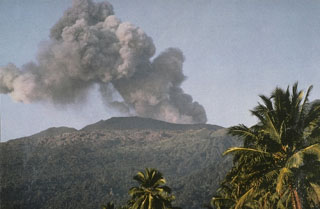 An ash plume rises from the summit of Dukono volcano in June 1991. The isolated volcano of Dukono at the northern end of Halmahera Island is one of Indonesia's most active, displaying more or less continuous explosive activity since 1933, when a new cinder cone was formed in Malupang Magiwe crater.
 The isolated volcano of Dukono at the northern end of Halmahera Island, is one of Indonesia's most active. Seen here in June 1991, Dukono has a broad profile and is capped by many compound craters. Dukono has displayed more or less continuous explosive activity since 1933, occasionally accompanied by lava flows.
 Nearly constant explosive eruptions keep the ash-blanketed crater floor of Dukono volcano unvegetated. This view from Gunung Heneowara peak on the southern crater rim shows Gunung Telori peak at the upper left and the small Gunung Dilekene pyroclastic cone at the right-center. The slopes of Gunung Mamuya stratovolcano rise at the extreme right above the coast. Dukono has been in continuous eruption since 1933.
 There are no samples for Dukono in the Smithsonian's NMNH Department of Mineral Sciences Rock and Ore collection.
| Copernicus Browser | The Copernicus Browser replaced the Sentinel Hub Playground browser in 2023, to provide access to Earth observation archives from the Copernicus Data Space Ecosystem, the main distribution platform for data from the EU Copernicus missions. |
| MIROVA | Middle InfraRed Observation of Volcanic Activity (MIROVA) is a near real time volcanic hot-spot detection system based on the analysis of MODIS (Moderate Resolution Imaging Spectroradiometer) data. In particular, MIROVA uses the Middle InfraRed Radiation (MIR), measured over target volcanoes, in order to detect, locate and measure the heat radiation sourced from volcanic activity. |
| MODVOLC Thermal Alerts | Using infrared satellite Moderate Resolution Imaging Spectroradiometer (MODIS) data, scientists at the Hawai'i Institute of Geophysics and Planetology, University of Hawai'i, developed an automated system called MODVOLC to map thermal hot-spots in near real time. For each MODIS image, the algorithm automatically scans each 1 km pixel within it to check for high-temperature hot-spots. When one is found the date, time, location, and intensity are recorded. MODIS looks at every square km of the Earth every 48 hours, once during the day and once during the night, and the presence of two MODIS sensors in space allows at least four hot-spot observations every two days. Each day updated global maps are compiled to display the locations of all hot spots detected in the previous 24 hours. There is a drop-down list with volcano names which allow users to 'zoom-in' and examine the distribution of hot-spots at a variety of spatial scales. |
|
WOVOdat
Single Volcano View Temporal Evolution of Unrest Side by Side Volcanoes |
WOVOdat is a database of volcanic unrest; instrumentally and visually recorded changes in seismicity, ground deformation, gas emission, and other parameters from their normal baselines. It is sponsored by the World Organization of Volcano Observatories (WOVO) and presently hosted at the Earth Observatory of Singapore.
GVMID Data on Volcano Monitoring Infrastructure The Global Volcano Monitoring Infrastructure Database GVMID, is aimed at documenting and improving capabilities of volcano monitoring from the ground and space. GVMID should provide a snapshot and baseline view of the techniques and instrumentation that are in place at various volcanoes, which can be use by volcano observatories as reference to setup new monitoring system or improving networks at a specific volcano. These data will allow identification of what monitoring gaps exist, which can be then targeted by remote sensing infrastructure and future instrument deployments. |
| Volcanic Hazard Maps | The IAVCEI Commission on Volcanic Hazards and Risk has a Volcanic Hazard Maps database designed to serve as a resource for hazard mappers (or other interested parties) to explore how common issues in hazard map development have been addressed at different volcanoes, in different countries, for different hazards, and for different intended audiences. In addition to the comprehensive, searchable Volcanic Hazard Maps Database, this website contains information about diversity of volcanic hazard maps, illustrated using examples from the database. This site is for educational purposes related to volcanic hazard maps. Hazard maps found on this website should not be used for emergency purposes. For the most recent, official hazard map for a particular volcano, please seek out the proper institutional authorities on the matter. |
| IRIS seismic stations/networks | Incorporated Research Institutions for Seismology (IRIS) Data Services map showing the location of seismic stations from all available networks (permanent or temporary) within a radius of 0.18° (about 20 km at mid-latitudes) from the given location of Dukono. Users can customize a variety of filters and options in the left panel. Note that if there are no stations are known the map will default to show the entire world with a "No data matched request" error notice. |
| UNAVCO GPS/GNSS stations | Geodetic Data Services map from UNAVCO showing the location of GPS/GNSS stations from all available networks (permanent or temporary) within a radius of 20 km from the given location of Dukono. Users can customize the data search based on station or network names, location, and time window. Requires Adobe Flash Player. |
| DECADE Data | The DECADE portal, still in the developmental stage, serves as an example of the proposed interoperability between The Smithsonian Institution's Global Volcanism Program, the Mapping Gas Emissions (MaGa) Database, and the EarthChem Geochemical Portal. The Deep Earth Carbon Degassing (DECADE) initiative seeks to use new and established technologies to determine accurate global fluxes of volcanic CO2 to the atmosphere, but installing CO2 monitoring networks on 20 of the world's 150 most actively degassing volcanoes. The group uses related laboratory-based studies (direct gas sampling and analysis, melt inclusions) to provide new data for direct degassing of deep earth carbon to the atmosphere. |
| Large Eruptions of Dukono | Information about large Quaternary eruptions (VEI >= 4) is cataloged in the Large Magnitude Explosive Volcanic Eruptions (LaMEVE) database of the Volcano Global Risk Identification and Analysis Project (VOGRIPA). |
| EarthChem | EarthChem develops and maintains databases, software, and services that support the preservation, discovery, access and analysis of geochemical data, and facilitate their integration with the broad array of other available earth science parameters. EarthChem is operated by a joint team of disciplinary scientists, data scientists, data managers and information technology developers who are part of the NSF-funded data facility Integrated Earth Data Applications (IEDA). IEDA is a collaborative effort of EarthChem and the Marine Geoscience Data System (MGDS). |

