Keyword Collections | Keyword "collapse scarp"
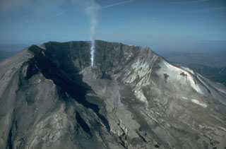 The large, horseshoe-shaped crater left by the collapse of Mount St. Helens on 18 May 1980, is typical of scarps created by massive volcanic landslides. The collapse removed nearly 1 km of the summit, leaving a 2 x 3.5 km crater open to the north. This June 1982 view shows a lava dome that began growing within the new crater.
Photo by Steve Brantley, 1982 (U.S. Geological Survey).
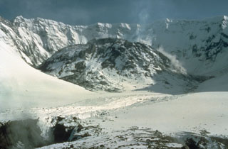 Four years after the powerful 18 May 1980 eruption of Mount St. Helens, a lava dome partially fills the crater. The dome, seen here from the north on 16 May 1984, grew during episodic periods of rapid growth that lasted from 1980 until 1986. By the end of the eruption the dome filled much of the crater floor, reaching a width of 1,100 m and a height of 250 m.
Photo by Lyn Topinka, 1984 (U.S. Geological Survey).
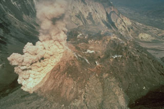 An ash plume rises above a rockfall on the south side of the Mount St. Helens dome during a period of lava dome growth in June 1985. Lava dome growth occurred intermittently from 1980 to 1986.
Photo by Gene Iwatsubo, 1985 (U.S. Geological Survey).
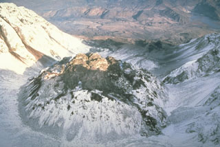 This view from above the south rim of the crater of Mount St. Helens shows the lava dome partially filling the crater on 28 October 1986, at the very end of the 1980-86 eruption. After six years of episodic growth the lava dome reached a height of 250 m and a diameter of 1,100 m.
Photo by Lyn Topinka, 1986 (U.S. Geological Survey).
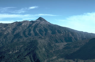 The lower area in the foreground of this view of Nevado de Colima is the moat of a large horseshoe-shaped caldera. The steep rim forms the forested arcuate ridge in the center. The caldera formed during collapse of the ancestral Colima, south of the current cone. The flanks of modern-day Colima, which have filled much of the caldera and overtopped in on three sides, appear to the lower right.
Photo by Jim Luhr, 1981 (Smithsonian Institution).
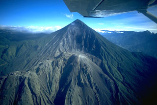 Santa María volcano is seen here in November 1994. The upper SW flank has a 1-km-wide crater formed during a catastrophic eruption in 1902. Two decades later the Santiaguito lava dome began growing at the base of the crater, forming the elongate ridge below the summit and to the left. Since 1922 the Santiaguito dome complex has exhibited frequent explosive activity accompanying episodic periods of dome growth and lava extrusion.
Copyrighted photo by Stephen O'Meara, 1994.
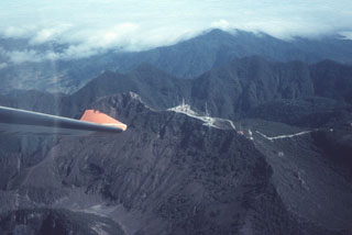 The summit of Barú volcano is just above the wing tip in this view from the SE. Communication towers line the ridge to the right of the summit. Behind it is the northern wall of a large horseshoe-shaped collapse scarp. The Pleistocene Volcán Colorado is under clouds to the upper right.
Photo by Tom Casadevall, 1994 (U.S. Geological Survey).
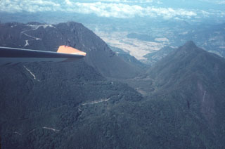 The outer eastern flanks of the large Volcán Barú collapse scar are in the foreground, with the northern scarp forming the ridge to the right. The road to the left crosses over the scarp into its moat and then up to the top of a post-collapse lava dome complex that forms the summit.
Photo by Tom Casadevall, 1994 (U.S. Geological Survey).
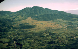 The large flank collapse scar of Volcán Barú is seen here from the west, with its northern wall extending downward left of the summit. The summit itself is a large lava dome complex constructed within the scarp near its eastern headwall. The vegetated horizontal N-S-trending ridge below and to the right of the summit dome complex are segments of the former edifice that slid down intact. The towns of Nuevo California and Hato del Volcán are at the base of the volcano to the right.
Photo by Kathleen Johnson, 1998 (University of New Orleans).
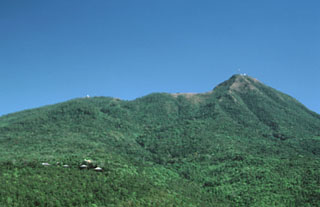 Mount Popa in central Myanmar is seen here from the town of Popa on the W flank. The summit of the volcano forms the back headwall of a large horseshoe-shaped collapse scar produced by collapse of the edifice. This 1.6-km-wide, 850-m-deep crater opens to the NW, in the direction of the ridge on the left horizon. The 3 km3 debris avalanche deposit to the N covers an area of 27 km2.
Photo by Sorena Sorensen, 2000 (Smithsonian Institution).
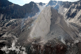 Moderate explosive eruptions beginning in October 2004 at Mount St. Helens were followed by the extrusion of a lava dome. This 21 June 2005 view from the NW shows the new dome with the 1980 crater wall in the background. The smooth-surfaced part of the dome, known informally as the Whaleback, formed by slow extrusion of viscous lava. The rougher surface to the right formed when portions of the dome collapsed, forming a talus slope. The crevassed, ash-covered surface of an uplifted glacier is visible to the left.
Photo courtesy of Cascades Volcano Observatory, U.S. Geological Survey.
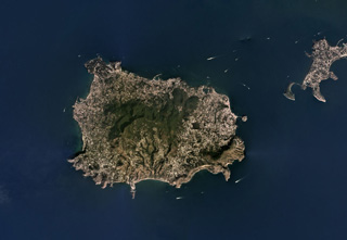 The Ischia volcanic complex forms a 6 x 9 km island in the Bay of Naples and is part of the Phlegraean Volcanic District. It is shown in this September 2019 Planet Labs satellite image monthly mosaic (N is at the top). The vegetated area is a resurgent block and the high point of the island. An arcuate collapse scarp in near the center on the island, opening towards the south.
Satellite image courtesy of Planet Labs Inc., 2019 (https://www.planet.com/).


