Theme Collections | Ailsa Naismith Photos
Theme collections are galleries not specifically related to volcanic hazards, processes, research, types, or features. This includes subjects such as different satellite platforms, astronaut photos from the Space Shuttle, specific photographers, or other special collections.
Image Gallery for Ailsa Naismith Photos
Ailsa Naismith is a research volcanologist at the University of Bristol, England. Her work focusses on unravelling the physical triggers of volcanic hazards and learning how these hazards unfold against social and political landscapes that convert the hazards into disaster. She applies creative methods to answer these questions in volcanic regions of Central America. Website: https://reasoningwithvolcanoes.com/. There are 30 images available.
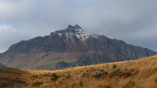
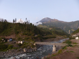 The NE flank of Tungurahua is seen here on 4 December 2015 from the town of Palictahua, near the Iglesia Católica de Cristo del Consuelo. Lahars at Tungurahua frequently travel large distances and occasionally cause road closures around the volcano. The foreground shows a large concrete block in front of the existing bridge that may be remains of an older damaged structure.
Photo by Ailsa Naismith, 2015.
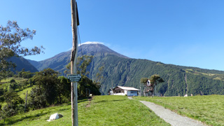 This 3 December 2015 photo shows the Volcán Tungurahua SSW flank from the Casa de Arbol, where IG-EPN operate a seismic station (Runtun). The station is managed by a member of the vigía network, which is a community based monitoring system of volunteers who observe nearby volcanoes and communicate activity to Tungurahua Volcano Observatory volcanologists and local officials. A weak degassing plume is dispersing to the right from the summit, which is also under a small meteorological cloud.
Photo by Ailsa Naismith, 2015.
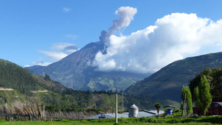 This 21 October 2015 photo shows an ash plume rising from Tungurahua, seen from the Observatorio del Volcán Tungurahua (OVT) to the NNW, near the village of Patate, operated by the Instituto Geofisico de la Escuela Politecnico Nacional (IG-EPN). Activity in 2015 was characterized by frequent ash and gas emissions and a variety of seismicity, including volcano-tectonic and long-period events.
Photo by Ailsa Naismith, 2015.
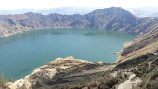
 The Quilotoa caldera walls rise around 400 m above the lake, exposing the rocks that formed the previous edifice and intrusions that pushed through them. The high point to the right is the SE lava dome. Bathymetry suggests that several events formed the caldera, with an older and deeper western caldera.
Photo by Ailsa Naismith, 2015.
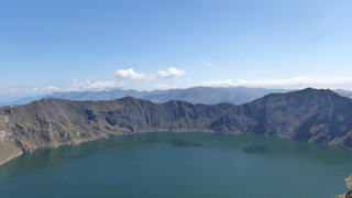
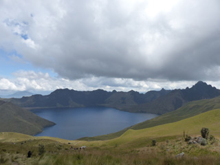
 The 3-km-wide Quilotoa caldera resulted from several collapse events and contains a turquoise lake approximately 250 m deep. Intrusions and lava domes are exposed within the crater walls, with the largest being 1.3 km diameter and 400 m high in the ESE wall visible on the far side of this 2015 photo. Behind the caldera rim is the Interandean Valley.
Photo by Ailsa Naismith, 2015.
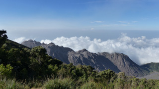
 This October 2015 view is from the summit of Rucu Pichincha (“Old Man Pichincha” in the indigenous Quechua language) facing west towards the Guagua Pichincha (“Baby Pichincha”) vent. Eruptions have produced ashfall that has impacted Quito, 14 km W. The recently active vent is situated within a landslide scarp that opens towards the SW, and an older landslide scarp is on the western flank.
Photo by Ailsa Naismith, 2015.
 The Mojanda summit caldera formed during a Plinian eruption ~200,000 years ago and now has three lakes. In the indigenous Quechua language they are Karikucha (Male Lake), Yanakucha (Black Lake), and Warmikucha (Female Lake). This October 2015 photograph is looking E towards Karikucha lake from the upper slopes of Mojanda.
Photo by Ailsa Naismith, 2015.
 A small lake is seen here between the two peaks of Illiniza, with the flank of Illiniza Norte to the right and Illiniza Sur to the left.
Photo by Ailsa Naismith, 2015.
 These two edifices form the Illiniza volcanic complex. Seen here from about 4 km NE, Illiniza Norte is to the right and Illiniza is to the left.
Photo by Ailsa Naismith, 2015.
 Illiniza Sur is the older of the two peaks that form the Illiniza complex. This November 2015 view from the NE shows some of the stratigraphy exposed by extensive erosion.
Photo by Ailsa Naismith, 2015.
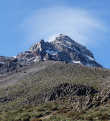
 Illiniza Norte is the shorter and older of the two peaks that form the Illiniza complex in Ecuador, with Illiniza Sur out of view to the left. The substantially eroded peak is seen here from the NE in November 2015, approaching from the Interandean Valley.
Photo by Ailsa Naismith, 2015.
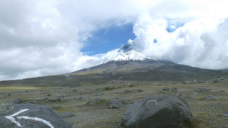 An eruption at Volcán Cotopaxi began on 14 August 2015 with a series of phreatic explosions in the crater, seen here from the N in December 2015 with ash deposits across the summit area. Explosive activity continued throughout August with continuous ash-and-gas emissions that declined towards the end of September 2015. Degassing at the summit produces the plume rises towards the towards the NW.
Photo by Ailsa Naismith, 2015.
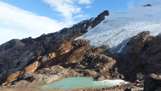 This December 2015 photograph shows the western flank of Volcán Cayambe with a small glacial lake (about 2 km down the SW flank), just above the Refugio Ruales Oleas Bergé. The presence of an ice cap at its summit represents a significant hazard, because melting of the ice by even small eruptions could generate large-volume lahars or debris flows.
Photo by Ailsa Naismith, 2015.
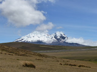 Volcán Antisana is seen here looking NE from highway E20 in December 2015. Northeast Peak is to the right and the East Ridge is to the left, with a collapse scarp between them.
Photo by Ailsa Naismith, 2015.
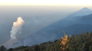
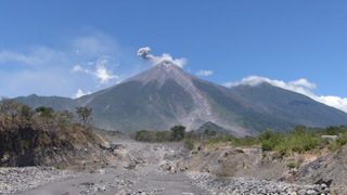 An ash plume from a small explosion at Fuego is being dispersed towards the E by the wind in this 8 March 2020 photo taken from the new Las Lajas bridge. A new bridge was constructed after the previous one was destroyed by the 3 June 2018 eruption that devastated nearby areas. The ravine in the foreground is Barranca Las Lajas, which channeled the majority of pyroclastic flow material produced in the 3 June eruption. Deposits from these pyroclastic flows are visible in the foreground, with dead trees and scorched vegetation on the left margin of the ravine showing some of the impacts of the hot flow.
Photo by Ailsa Naismith, 2020.
 This 28 February 2020 photo shows typical degassing at El Caliente dome producing a vertical gas plume. The dome is one of four that form the Santiaguito dome complex at Santa Maria, with the 1902 crater wall behind it.
Photo by Ailsa Naismith, 2020.
 A rockfall descends the S flank of the Caliente dome of the Santiaguito dome complex at Santa Maria volcano on 28 February 2020, causing a small ash plume to rise above it. The Santa Maria edifice is behind and just right of the dome, with the large 1902 crater wall extending down its SW flank.
Photo by Ailsa Naismith, 2020.
 This view of El Caliente dome from the lookout point on the W flank of Santa Maria shows moderate degassing forming a vertical gas plume. The dome is part of the Santiaguito dome complex with the other domes to the right.
Photo by Ailsa Naismith, 2020.
 This view from the lookout point on the W flank of Santa Maria shows the Santiaguito dome complex on 27 February 2020. From left to right (approximately NE-SW) the domes are El Caliente, La Mitad, El Monje, and El Brujo.
Photo by Ailsa Naismith, 2020.
 Incandescent bombs ejected from Fuego’s summit vent impact the upper flanks on 20 February 2020. The ballistic trajectories are visible at night with initial velocities reaching several hundred meters per second. This photo is taken from Observatorio del Volcán de Fuego (OVFGO), Panimaché Uno, Chimaltenango, below the SW flank.
Photo by Ailsa Naismith, 2020.
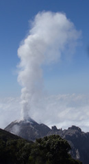
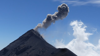 This 18 February 2020 photo shows an example of a typical Vulcanian explosion at Fuego The view is from the lookout area on Volcán Acatenango, about 2 km N, with the ash plume dispersing to the W.
Photo by Ailsa Naismith, 2020.
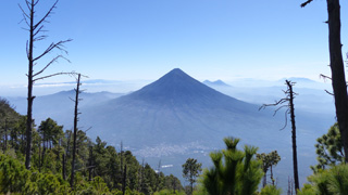 Volcán de Agua is seen here from the E flank of Volcán Acatenango. The peaks of Cerro Grande and Volcán Pacaya are visible behind Agua (right) and the town of Alotenango is below it.
Photo by Ailsa Naismith, 2020.
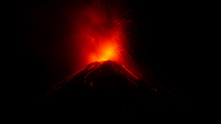
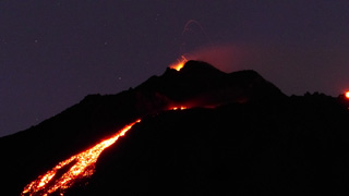 Lava flows down the upper eastern flank of Pacaya are visible in this photo from the night of 17 February 2020. Incandescent lava fountaining from the active Mackenney cone above is the source of the flow.
Photo by Ailsa Naismith, 2020.
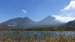 This 2018 view of Volcán Tolimán (left) and Volcán Atitlán (right) is from the shores of Lake Atitlan opposite the town of Santiago Atitlan (just out of view to the left). The cones formed along the southern rim of the Atitlán III caldera with the lake in the foreground filling the northern area.
Photo by Ailsa Naismith, 2018.
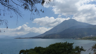 This 2018 view of Volcán San Pedro of Guatemala is from the W near San Juan La Laguna, with Volcán Tolimán volcano behind it. These cones along with the active Atitlán cone behind them have formed along the rim of the Atitlán III caldera, with the lake in the foreground filling the northern area.
 Photo by Ailsa Naismith, 2018.
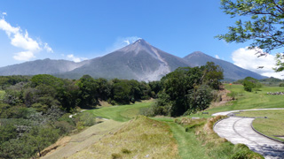
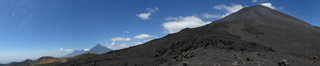 This February 2018 panorama shows the relative positions of several eastern Guatemalan volcanoes. From left to right are Fuego, Acatenango, Agua, and Pacaya.
Photo by Ailsa Naismith, 2018.
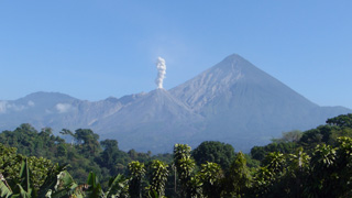
 Fuego (left) and Acatenango (right, behind) are seen here from La Reunion Golf Resort and Residences below the SE flank in March 2017. Barranca Las Lajas is the ravine from the summit down the flank, containing eruption deposits from the frequent activity. Weak degassing from the summit is producing a faint plume dispersing towards the SW.
Photo by Ailsa Naismith, 2017.
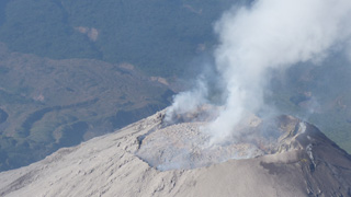 This 28 February 2017 photograph of El Caliente dome summit shows that the dome had nearly filled the crater. Pyroclastic flows from El Caliente are often caused by the partial collapse of an overflowing dome. Weak degassing is visible from the center and perimeter of the dome. Blocky lava flows produced from El Caliente vent are visible in the background.
Photo by Ailsa Naismith, 2017.
 This February 2017 view of El Caliente of the Santiaguito lava dome complex is from the Santa Maria summit (producing the shadow to the right). The other Santiaguito domes visible from left to right (approximately NE-SW) are El Caliente, La Mitad, El Monje, and El Brujo. El Caliente is degassing through its characteristic ring-shaped fracture network.
Photo by Ailsa Naismith, 2017.
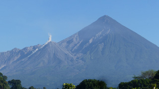
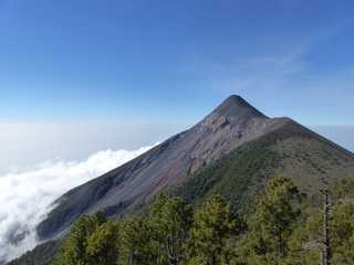 Fuego is seen here from Volcán Acatenango in February 2017. The ridge to the right of Fuego’s summit is a remnant of the older La Meseta edifice that underwent collapse approximately 9,000 years ago. The Barrancas Hondas and Las Lajas ravines that channel pyroclastic flows and lahars are visible on Fuego’s eastern flanks (left side); Honda is closer and deeper, with areas of red oxidation.
Photo by Ailsa Naismith, 2017.